
气候变化情景下广东省降雨诱发型滑坡灾害潜在分布及预测
|
麦鉴锋(1999—),男,广东广州人,本科生,研究方向为地理信息科学与国土空间规划。E-mail: 20182621017@m.scnu.edu.cn |
收稿日期: 2021-04-06
要求修回日期: 2021-07-22
网络出版日期: 2022-01-25
基金资助
国家自然科学基金项目(41901349)
华南师范大学青年拔尖人才启动基金项目(8S0472)
广东省普通高校青年创新人才类项目(2018KQNCX054)
广东省省级科技计划项目(2021B1111610001)
广东省省级科技计划项目(2018B020207002)
版权
Predicting Potential Rainfall-Triggered Landslides Sites in Guangdong Province (China) using MaxEnt Model under Climate Changes Scenarios
Received date: 2021-04-06
Request revised date: 2021-07-22
Online published: 2022-01-25
Supported by
National Natural Science Foundation of China, No(41901349)
The Startup Foundation for Talented Scholars in South China Normal University, No(8S0472)
Foundation for Young Innovation Talents in Higher Education of Guangdong, China (Natural Science), No(2018KQNCX054)
The Science and Technology Program of Guangdong Province, China, No(2021B1111610001)
The Science and Technology Program of Guangdong Province, China, No(2018B020207002)
Copyright
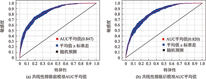
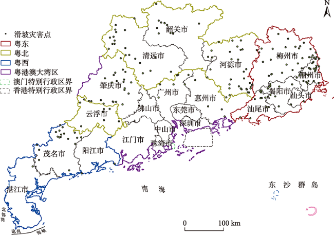
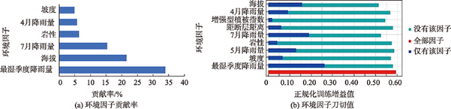
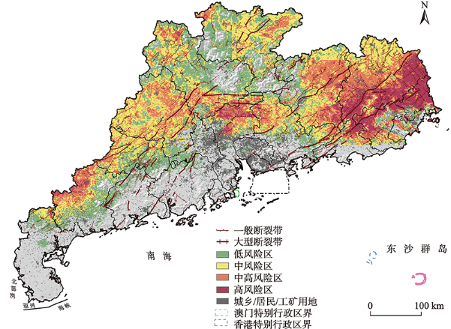
降雨诱发型滑坡灾害导致了人居环境的破坏并带来巨大的经济损失,尤其是在经济高度发达的粤港澳大湾区城市群。因此,急需有关降雨诱发型滑坡灾害分布的影响因素以及未来气候变化情景下潜在分布的研究。本文从气候变化角度出发,基于最大熵(MaxEnt)模型,结合气候、地形、地表覆盖等数据,揭示不同影响因素对当前气候环境下广东省滑坡空间分布的作用,进而阐述了未来气候情景下滑坡的潜在分布。结果表明:① 影响滑坡灾害空间分布的主要因子为最湿季度降雨量、7月降雨量、海拔和4月降雨量;② 当最湿季度降雨量处于593~742 mm、7月降雨量处于139~223 mm、海拔处于81~397 m和4月降雨量处于154~186 mm之间时,滑坡灾害较易发生;③ 受到气候变化的影响,当前密集分布于粤东地区的滑坡灾害高风险区的潜在分布范围和危害性总体呈现扩大趋势。本研究的结果可以为国土空间规划及城市群灾害预防提供科学依据。
麦鉴锋 , 冼宇阳 , 刘桂林 . 气候变化情景下广东省降雨诱发型滑坡灾害潜在分布及预测[J]. 地球信息科学学报, 2021 , 23(11) : 2042 -2054 . DOI: 10.12082/dqxxkx.2021.210182
As a natural disaster, rainfall-triggered landslide causes tremendous losses to mankind and then seriously affects living environments of mankind, especially in highly economically developed urban agglomeration areas. Many scholars have carried out data collection and related researches from the perspectives of real-time monitoring, process mechanism analysis, risk assessment, and prediction. However, the abovementioned studies lack the prediction of the potential distribution of landslides from the perspective of climate change. Therefore, we employed the Maximum Entropy (MaxEnt) model to simulate the current distribution of potential rainfall-triggered landslides combined with a series of indicators related to precipitation, including geology, topography, vegetation cover, the precipitation of April, precipitation of May, precipitation of July, precipitation of wettest quarter, Enhanced Vegetation Index (EVI), elevation, slope, lithology, and distance to fault. Then we revealed different effects of those influencing factors on the spatial distribution of landslides in Guangdong Province. Finally, we predicted the future potential distribution of rainfall-triggered landslides under the Shared Socio-economic Pathways (SSPs) scenarios from 2021 to 2060. The results show that the average AUC (Area under the receiving operator curve) value of the model simulation was 0.820, exceeding the standard of "very accurate" simulation effect, and the Kappa coefficient was also 0.823 after 10 repeated simulations. We found that precipitation of wettest quarter, precipitation of July, precipitation of April, and elevation significantly affected the distribution of landslides, in which the wettest season rainfall was the most contributing factor. Specifically, the precipitation of wettest quarter between 593~742 mm, precipitation of July between 139~223 mm, precipitation of April between 154~186 mm, and elevation between 81~397 m were highly correlated to the occurrence of rainfall-triggered landslides. Currently, the area of high risk of rainfall-triggered landslides in Guangdong Province was 1.28×10⁴ km2, accounting for 7.59% of Guangdong Province. Spatially, it is mainly distributed in the eastern part of Guangdong Province. However, under three future SSPs scenarios (SSP1-2.6, SSP3-7.0, and SSP5-8.5) of two periods (i.e., 2021—2040, 2041—2060), the potential distribution range and harm of the areas above the risk in Guangdong Province have shown an expansion trend. The area increased the most under the SSP1-2.6 scenario during the period of 2041—2060. The simulated future high-risk distribution of landslide had potential harm to Guangdong-Hong Kong-Macao Greater Bay Area and Eastern Guangdong urban agglomeration. The findings can provide scientific evidence for the future smart sustainable territory development plan from the perspective of prediction of landslide distribution.
表1 4种共享社会经济路径[30]Tab. 1 Four kinds of shared socio-economic pathways |
| 情景 | 描述 |
|---|---|
| SSP1-2.6 | 是可持续发展路径情景,对RCP2.6情景进行更新,设定辐射强迫在2100年达到2.6 W/m2 |
| SSP2-4.5 | 是中度发展路径情景,对RCP4.5情景进行更新,设定辐射强迫在2100年达到4.5 W/m2 |
| SSP3-7.0 | 是局部发展路径情景,新设置的排放情景,设定辐射强迫在2100年达到7.0 W/m2 |
| SSP5-8.5 | 是常规发展路径情景,对RCP8.5情景进行更新,设定辐射强迫在2100年达到8.5 W/m2 |
表2 影响滑坡灾害的环境因子Tab. 2 Environment variables affecting landslides |
| 一级指标 | 二级指标 | 来源 | 空间分辨率 |
|---|---|---|---|
| 气候因子 | 年平均降雨量 | WorldClim | 30″, 2.5′ |
| 最湿月降雨量 | WorldClim | 30″, 2.5′ | |
| 降雨量季节变异系数 | WorldClim | 30″, 2.5′ | |
| 最湿季度降雨量 | WorldClim | 30″, 2.5′ | |
| 最热季度降雨量 | WorldClim | 30″, 2.5′ | |
| 3月降雨量 | WorldClim | 30″, 2.5′ | |
| 4月降雨量 | WorldClim | 30″, 2.5′ | |
| 5月降雨量 | WorldClim | 30″, 2.5′ | |
| 6月降雨量 | WorldClim | 30″, 2.5′ | |
| 7月降雨量 | WorldClim | 30″, 2.5′ | |
| 8月降雨量 | WorldClim | 30″, 2.5′ | |
| 9月降雨量 | WorldClim | 30″, 2.5′ | |
| 地形因子 | 海拔 | WorldClim | 30″ |
| 坡度 | WorldClim | 30″ | |
| 坡向 | WorldClim | 30″ | |
| 地质因子 | 岩性 | GLiM | 30′ |
| 距断层距离 | Geodb | 30″, 2.5′ | |
| 地表覆盖 | 2018年土地利用数据 | RESDC | 1 km |
| 增强型植被指数 | NASA | 0.5 km |
表3 广东省各情景下滑坡灾害高风险及中高风险区面积、比例及增加率Tab. 3 Area, proportion and increasing rate of high-risk and medium-high risk areas of landslide disaster under various scenarios in Guangdong |
| 时间段 | 总面积/×104 km2 | 面积比/% | 增加率/% |
|---|---|---|---|
| 2021—2040,SSP1-2.6 | 6.41 | 38.00 | 12.80 |
| 2021—2040,SSP3-7.0 | 4.40 | 26.08 | 0.89 |
| 2021—2040,SSP5-8.5 | 6.16 | 36.51 | 11.32 |
| 2041—2060,SSP1-2.6 | 8.36 | 49.56 | 24.36 |
| 2041—2060,SSP3-7.0 | 5.28 | 31.30 | 6.11 |
| 2041—2060,SSP5-8.5 | 5.68 | 33.67 | 8.48 |
表4 梅州市与韶关市各情景下最湿季度降雨量范围及高风险面积比Tab. 4 Precipitation range of Wettest Quarter and percent of risk areas in Meizhou and Shaoguan under various scenarios |
| 地区 | 时间段 | 最低值/mm | 最高值/mm | 中位数/mm | 高风险面积比/% |
|---|---|---|---|---|---|
| 梅州市 | 当前 | 597 | 849 | 675 | 32.97 |
| 韶关市 | 当前 | 649 | 889 | 758 | 0.72 |
| 2021—2040(SSP1-2.6) | 640 | 804 | 720 | 0.31 | |
| 2021—2040(SSP3-7.0) | 662 | 866 | 774 | 0.15 | |
| 2021—2040(SSP5-8.5) | 636 | 866 | 739 | 0.12 | |
| 2041—2060(SSP1-2.6) | 584 | 780 | 668 | 5.88 | |
| 2041—2060(SSP3-7.0) | 596 | 835 | 700 | 17.16 | |
| 2041—2060(SSP5-8.5) | 609 | 811 | 695 | 6.76 |
| [1] |
|
| [2] |
刘广润, 晏鄂川, 练操. 论滑坡分类[J]. 工程地质学报, 2002, 10(4):339-342.
[
|
| [3] |
|
| [4] |
于宪煜. 基于多源数据和多尺度分析的滑坡易发性评价方法研究[D]. 武汉:中国地质大学, 2016.
[
|
| [5] |
|
| [6] |
许强, 董秀军, 李为乐. 基于天-空-地一体化的重大地质灾害隐患早期识别与监测预警[J]. 武汉大学学报·信息科学版, 2019, 44(7):957-966.
[
|
| [7] |
徐靓, 程刚, 朱鸿鹄. 基于空天地内一体化的滑坡监测技术研究[J]. 激光与光电子学进展, 2021, 58(9):98-111.
[
|
| [8] |
|
| [9] |
唐亚明. 陕北黄土滑坡风险评价及监测预警技术方法研究[D]. 北京:中国地质大学(北京), 2012.
[
|
| [10] |
黄发明. 基于3S和人工智能的滑坡位移预测与易发性评价[D]. 武汉:中国地质大学, 2017.
[
|
| [11] |
曹颖. 单体滑坡灾害风险评价与预警预报——以万州区塘角1号滑坡为例[D]. 武汉:中国地质大学, 2016.
[
|
| [12] |
殷坤龙, 陈丽霞, 张桂荣. 区域滑坡灾害预测预警与风险评价[J]. 地学前缘, 2007, 14(6):85-97.
[
|
| [13] |
王念秦, 王永锋, 罗东海, 等. 中国滑坡预测预报研究综述[J]. 地质论评, 2008, 54(3):355-361.
[
|
| [14] |
|
| [15] |
|
| [16] |
|
| [17] |
|
| [18] |
|
| [19] |
|
| [20] |
|
| [21] |
|
| [22] |
宫清华, 黄光庆, 张俊香. 广东省小流域地区降雨诱发的滑坡灾害预警体系探讨[J]. 气象科技进展, 2015, 5(4):53-56.
[
|
| [23] |
陈悦丽. 降雨型滑坡动力数值预报模式GRAPES-LFM的研究[D]. 南京:南京信息工程大学, 2015.
[
|
| [24] |
|
| [25] |
|
| [26] |
田春山, 刘希林, 汪佳. 基于CF和Logistic回归模型的广东省地质灾害易发性评价[J]. 水文地质工程地质, 2016, 43(6):154-161,170.
[
|
| [27] |
林本海, 杨树庄, 朱伯善, 等. 广东省地质构造与岩土工程基本特征[J]. 岩石力学与工程学报, 2006, 25(S2):3337-3346.
[
|
| [28] |
|
| [29] |
|
| [30] |
|
| [31] |
|
| [32] |
|
| [33] |
|
| [34] |
|
| [35] |
|
| [36] |
|
| [37] |
|
| [38] |
广东省地质局. 广东省2019年度地质灾害防治数据[EB/OL].http://dzj.gd.gov.cn/ywlc/content/post_2725543.html.
[ Guangdong Geological Bureau. Geological hazard control data of Guangdong Province in 2019[EB/OL].http://dzj.gd.gov.cn/ywlc/content/post_2725543.html.
|
| [39] |
|
| [40] |
林泽雨, 刘爱华. 广东地区滑坡灾害分布特征与预警措施分析[J]. 人民长江, 2019, 50(S1):90-92.
[
|
| [41] |
Worldclim[EB/OL]. https://www.worldclim.org/data/index.html.
|
| [42] |
胡家梁. 基于AHP-信息量法的密云区地质灾害易发性评价[J]. 路基工程, 2020(5):11-17.
[
|
| [43] |
杨根云, 周伟, 方教勇. 基于信息量模型和数据标准化的滑坡易发性评价[J]. 地球信息科学学报, 2018, 20(5):674-683.
[
|
| [44] |
|
| [45] |
地质科学数据出版中心[EB/OL] 质科学数据出版中心[EB/OL]. http://geodb.ngac.org.cn/cn/page/index.
[ Geoscientific Data & Discovery Publishing Center[EB/OL]eoscientific Data & Discovery Publishing Center[EB/OL]. http://geodb.ngac.org.cn/cn/page/index.
|
| [46] |
资源环境科学与数据中心[EB/OL]. https://www.resdc.cn/data.aspx?DATAID=264.
[ Resource and Environment Science and Data Center[EB/OL]. https://www.resdc.cn/data.aspx?DATAID=264.
|
| [47] |
National Aeronautics and Space Administration[EB/OL]. https://modis.gsfc.nasa.gov/data/dataprod/mod13.php.
|
| [48] |
|
| [49] |
|
| [50] |
|
| [51] |
黄建龙, 刘亦农, 曾伟国. 粤港澳大湾区地质特点与地质环境保护策略分析[J]. 人民珠江, 2019, 40(9):103-109.
[
|
| [52] |
闫文晓. 地质环境条件在国土空间规划中的应用研究[J]. 上海国土资源, 2019, 40(2):56-60.
[
|
| [53] |
|
| [54] |
|
| [55] |
|
| [56] |
|
| [57] |
朱耿平, 乔慧捷. Maxent模型复杂度对物种潜在分布区预测的影响[J]. 生物多样性, 2016, 24(10):1189-1196.
[
|
| [58] |
|
| [59] |
|
| [60] |
|
| [61] |
|
| [62] |
|
| [63] |
|
| [64] |
|
| [65] |
|
| [66] |
涂长红, 商建林, 谢叶彩, 等. 改进的灰色关联分析在滑坡危险性评价中的应用——以广东省滑坡危险性评价为例[J]. 灾害学, 2007, 22(1):86-89.
[
|
| [67] |
魏平新, 汤连生, 张建国, 等. 基于GIS的广东省滑坡灾害区划研究[J]. 水文地质工程地质, 2005, 32(4):6-9.
[
|
| [68] |
|
| [69] |
|
| [70] |
|
| [71] |
易顺民. 广东省滑坡活动的时间分布规律研究[J]. 热带地理, 2007, 27(6):499-504.
[
|
| [72] |
郑书彦, 李占斌. 滑坡侵蚀研究[M]. 郑州: 黄河水利出版社, 2005.
[
|
| [73] |
王连新, 马建宏, 边智华. 水库滑坡与防治技术[M]. 武汉: 长江出版社, 2005.
[
|
| [74] |
|
| [75] |
|
| [76] |
|
| [77] |
|
| [78] |
|
/
| 〈 |
|
〉 |

