
国土空间开发适宜性评价的理论、方法与技术应用
|
刘小波(1990—),男,四川资阳人,博士生,主要从土地资源开发与评价研究。E-mail: xbliu@imde.ac.cn |
收稿日期: 2021-01-21
要求修回日期: 2021-03-16
网络出版日期: 2022-02-25
基金资助
中国科学院战略性先导科技专项(A类)子课题(XDA23090501)
中国科学院西部之光B类人才项目(Y9R2140)
版权
Theory, Method and Technological Application of Territorial Spatial Development Suitability Evaluation
Received date: 2021-01-21
Request revised date: 2021-03-16
Online published: 2022-02-25
Supported by
The Strategic Priority Research Program of the Chinese Academy of Sciences(XDA23090501)
The “Light of West China” program of the Chinese Academy of Sciences(Y9R2140)
Copyright
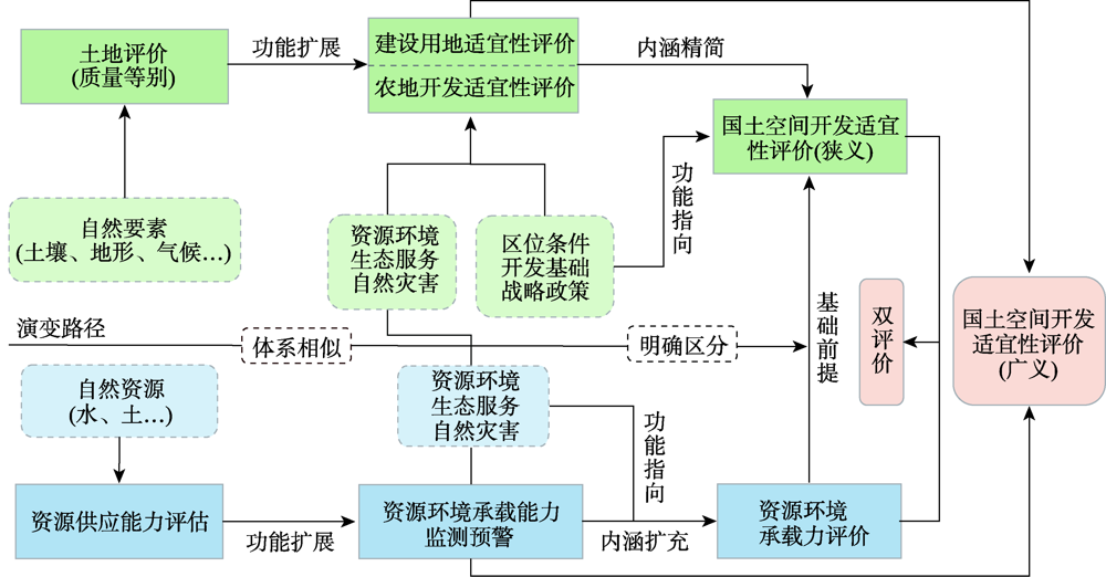
国土空间开发适宜性评价既是长期人地关系优化调控研究领域的重要研究内容,也是当前各层级国土空间规划编制的重要基础工作。该文运用文献调研、总结、对比分析等方法,围绕国土空间开发适宜性评价的概念内涵、演进历程、评价方法以及技术手段等方面进行综述,指出现有研究存在的不足与仍需深入研究的领域和方向。主要结论如下:① 当前国土空间开发适宜性评价已具有较为丰富的研究案例,但对国土空间开发的多目标协同评价关注不够,评价指标体系的精细化程度不足,多尺度综合研究存在短板;基础信息数据尚难满足全域、全要素、全时相的评价要求;地球信息技术支撑“智慧评价”的能力不足;② 未来应进一步加强国土空间开发适宜性评价基础理论研究,深化对评价内涵的理论认知,构建指标独立、系统高效的评价体系;丰富多尺度适宜性评价案例,重视区域发展定位,关注区域发展的特殊需求和产业优势,提升评价指标体系的精细化水平;紧跟“智慧社会”建设步伐,加强地球信息技术与物联网、大数据、云计算等新兴技术的融合应用,促进国土空间多源大数据的制定与适宜性评价体系的有效衔接,为实现“智慧评价”提供有力的技术支撑。
刘小波 , 王玉宽 , 李明 . 国土空间开发适宜性评价的理论、方法与技术应用[J]. 地球信息科学学报, 2021 , 23(12) : 2097 -2110 . DOI: 10.12082/dqxxkx.2021.210037
Suitability evaluation of territorial space is the premise and basis for scientific territory space planning, transition of territory space governance mode and creation of high-quality territory spaces. It is of important significance to optimize the development and protection pattern of territory space and perfect subjective functional orientation of regions. Based on literature review, summary, inductive and comparative analysis, this study reviewed conceptual connotation, development course, evaluation units, evaluation index system, evaluation method, modern technologies and application framework of suitability evaluation of territory space development. It pointed out shortages of existing studies and it suggested to deepening research fields and directions. At present, the theory and practice of suitability evaluation of territorial space have made great breakthrough, and the evaluation index system has formed a more comprehensive system, and the evaluation methods show a trend of diversification. Although many studies have discussed suitability evaluation of territory space development, there are inadequate attentions to multi-objective collaborative evaluation of territory space development. Specifically, it fails to achieve satisfying results in refining of evaluation index system, multi-scale comprehensive study and intelligence level of evaluation methods. The firstly, the construction of the index system is lack of uniformity and standardization. Different studies are based on different goals and perspectives, and the index systems constructed are obviously different. Different scholars have great differences in the evaluation of the same area, which affects the objectivity of the evaluation results. The basic information data can not meet the evaluation requirements of the whole area, the whole element and the whole temporal phase. The ability of Geo-information science and technology to support "smart evaluation" is insufficient. Secondly, in the existing studies, the micro scale evaluation is the majority, the macro scale evaluation is less, and the multi-scale comprehensive evaluation research is very rare. Finally, there is a lack of integration and application of existing evaluation methods for the suitability of territorial space development with intelligent frontier technologies such as spatiotemporal big data, cloud computing, unmanned aerial vehicles, Internet of Things, and 5G network, and there is a huge space for future mining. In future, we need to do well in the following aspects. The firstly, it is suggested to carry out more multi-scale suitability evaluations, promote the integration, transformation and transmission of multi-scale evaluation. Secondly, improve standardization and refining of evaluation index system. Attach importance to the positioning of regional development, pay attention to the special needs and industrial advantages of regional development. In addition, follow the pace of "smart society" construction closely, strengthen the integration and application of earth information technology and Internet, database, cloud computing and other emerging technologies, promote the formulation of land and space multi-source big data and the effective integration of suitability evaluation system; couple GIS, remote sensing and big data to carry out information mining, and provide strong technical support for "smart evaluation".
表1 基于国土空间三生功能的适宜性评价指标差异性特征Tab. 1 Evaluation index of suitability for territorial space development |
| 一级类型 | 二级类型 | 代表性评价指标 | 评价重点 |
|---|---|---|---|
| 空间功能 | 生产功能 | 坡度、地形起伏度、地质条件(塌陷)、地块连片度、灾害危险性、基本农田保护 | 宜农条件、政策约束 |
| 生活功能 | 公共管理与服务水平、距各级道路距离、距中心城镇距离、 | 经济效益、区位条件 | |
| 生态功能 | 生态用地比例、植被覆盖率、湿地面积比重、水源涵养功能、水土流失敏感性 | 生态重要性、生态敏感性 |
| [1] |
林坚, 刘松雪, 刘诗毅. 区域—要素统筹:构建国土空间开发保护制度的关键[J]. 中国土地科学, 2018, 32(6):1-7.
[
|
| [2] |
蔡玉梅, 顾林生, 李景玉, 等. 日本六次国土综合开发规划的演变及启示[J]. 中国土地科学, 2008(6):76-80.
[
|
| [3] |
|
| [4] |
董祚继. 新时代国土空间规划的十大关系[J]. 资源科学, 2019, 41(9):1589-1599.
[
|
| [5] |
|
| [6] |
吴次芳. 国土空间规划[M]. 北京: 地质出版社, 2019:126-133.
[
|
| [7] |
中华人民共和国中央人民政府. 省级空间规划试点方案[EB/OL]. http://www.gov.cn/zhengce/2017-01/09/content_5158211.htm,2017-1-9.
[ Central People's Government of the People's Republic of China. Pilot program of provincial spatial planning[EB/OL]. http://www.gov.cn/zhengce/2017-01/09/content_5158211.htm,2017-1-9.
|
| [8] |
中华人民共和国自然资源部. 资源环境承载能力和国土空间开发适宜性评价指南(试行)[EB/OL]. http://gi.mnr.gov.cn/202001/t20200121_2498502.html,2020-1-19.
[Ministry of Natural Resources of the People's Republic of China. Guidelines for evaluating the carrying capacity of resources and environment and the suitability of territorial space development(trial implementation)[EB/OL]. http://gi.mnr.gov.cn/202001/t20200121_2498502.html,2020-1-19.
|
| [9] |
王亚飞, 樊杰, 周侃. 基于“双评价”集成的国土空间地域功能优化分区[J]. 地理研究, 2019, 38(10):2415-2429.
[
|
| [10] |
于婧, 陈艳红, 唐业喜, 等. 基于国土空间适宜性的长江经济带“三生空间”格局优化研究[J]. 华中师范大学学报(自然科学版), 2020, 54(4):632-639.
[
|
| [11] |
石龙宇, 冯运双, 高莉洁. 长三角县域国土空间开发适宜性评价方法研究——以长兴县为例[J]. 生态学报, 2020, 40(18):6495-6504.
[
|
| [12] |
樊杰, 周侃, 陈东. 生态文明建设中优化国土空间开发格局的经济地理学研究创新与应用实践[J]. 经济地理, 2013, 33(1):1-8.
[
|
| [13] |
董祚继. 从土地利用规划到国土空间规划——科学理性规划的视角[J]. 中国土地科学, 2020, 34(5):1-7.
[
|
| [14] |
钟珊, 赵小敏, 郭熙, 等. 基于空间适宜性评价和人口承载力的贵溪市中心城区城市开发边界的划定[J]. 自然资源学报, 2018, 33(5):801-812.
[
|
| [15] |
樊杰, 周侃, 王亚飞. 全国资源环境承载能力预警(2016版)的基点和技术方法进展[J]. 地理科学进展, 2017, 36(3):266-276.
[
|
| [16] |
徐勇, 张雪飞, 周侃, 等. 资源环境承载能力预警的超载成因分析方法及应用[J]. 地理科学进展, 2017, 36(3):277-285.
[
|
| [17] |
樊杰. 国家汶川地震灾后重建规划: 资源环境承载能力评价[M]. 北京: 科学出版社, 2009.
[
|
| [18] |
严金明, 陈昊, 夏方舟. “多规合一”与空间规划:认知、导向与路径[J]. 中国土地科学, 2017, 31(1):21-27.
[
|
| [19] |
杨帆, 宗立, 沈珏琳, 等. 科学理性与决策机制:“双评价”与国土空间规划的思考[J]. 自然资源学报, 2020, 35(10):2311-2324.
[
|
| [20] |
岳文泽, 王田雨. 资源环境承载力评价与国土空间规划的逻辑问题[J]. 中国土地科学, 2019, 33(3):1-8.
[
|
| [21] |
郝庆, 邓玲, 封志明. 面向国土空间规划的“双评价”:抗解问题与有限理性[J]. 自然资源学报, 2021, 36(3):541-551.
[
|
| [22] |
麦克哈格. 芮经纬译. 设计结合自然[M]. 天津: 天津大学出版社, 1967.
[
|
| [23] |
纪学朋, 黄贤金, 陈逸, 等. 基于陆海统筹视角的国土空间开发建设适宜性评价——以辽宁省为例[J]. 自然资源学报, 2019, 34(3):451-463.
[
|
| [24] |
刘耀林等. 土地评价理论、方法与系统开发[M]. 北京: 科学出版社, 2008.
[
|
| [25] |
|
| [26] |
|
| [27] |
|
| [28] |
|
| [29] |
|
| [30] |
|
| [31] |
彭建, 王仰麟, 宋治清, 等. 国内外土地持续利用评价研究进展[J]. 资源科学, 2003, 25(2):85-93.
[
|
| [32] |
|
| [33] |
|
| [34] |
陈传康, 高豫功, 俞孔坚, 等. 丹霞风景名胜区的旅游开发研究[J]. 地理学报, 1990, 45(3):284-294.
[
|
| [35] |
董黎明, 冯长春. 城市土地综合经济评价的理论方法初探[J]. 地理学报, 1989, 44(3):323-333.
[
|
| [36] |
倪绍祥, 陈传康. 我国土地评价研究的近今进展[J]. 地理学报, 1993, 48(1):75-83.
[
|
| [37] |
|
| [38] |
|
| [39] |
俞艳, 郭庆胜, 何建华, 等. 基于Web服务的土地适宜性评价PSE设计与实现[J]. 武汉大学学报·信息科学版, 2006, 31(6):544-547.
[
|
| [40] |
赵耀龙, 巢子豪. 历史GIS的研究现状和发展趋势[J]. 地球信息科学学报, 2020, 22(5):929-944.
[
|
| [41] |
张丽君. 欧盟空间规划与凝聚政策的启示[J]. 国土资源情报, 2011(11):36-43.
[
|
| [42] |
杨庆媛, 罗奎, 劳昕. 基于地理学视角的国际空间规划嬗变与启示[J]. 地理学报, 2020, 75(6):1223-1236.
[
|
| [43] |
董祚继. 新中国70年土地制度的演进及其经验[J]. 中国土地, 2019(10):4-15.
[
|
| [44] |
岳文泽, 吴桐, 王田雨, 等. 面向国土空间规划的“双评价”:挑战与应对[J]. 自然资源学报, 2020, 35(10):2299-2310.
[
|
| [45] |
赵轩, 彭建东, 樊智宇, 等. “双评价”视角下基于FLUS模型的武汉大都市区土地利用模拟和城镇开发边界划定研究[J]. 地球信息科学学报, 2020, 22(11):2212-2226.
[
|
| [46] |
张增祥, 汪潇, 温庆可, 等. 土地资源遥感应用研究进展[J]. 遥感学报, 2016, 20(5):1243-1258.
[
|
| [47] |
宋关福, 卢浩, 王晨亮, 等. 人工智能GIS软件技术体系初探[J]. 地球信息科学学报, 2020, 22(1):76-87.
[
|
| [48] |
樊杰. 中国主体功能区划方案[J]. 地理学报, 2015, 70(2):186-201.
[
|
| [49] |
车冰清, 孟德友, 陆玉麒, 等. 江苏省空间开发适宜性与土地利用效率的协调性分析[J]. 中国土地科学, 2017, 31(5):20-30.
[
|
| [50] |
迪力沙提·亚库甫, 严金明, 李强. 基于生态导向与自然条件约束的青海省国土空间开发适宜性评价研究[J]. 地理与地理信息科学, 2019, 35(3):94-98.
[
|
| [51] |
杨浩, 方超平, 林蕙灵, 等. 基于县域单元的福建省国土空间开发利用效率评价[J]. 中国人口·资源与环境, 2017, 27(S1):109-113.
[
|
| [52] |
徐磊, 董捷, 李璐, 等. 基于功能分区视角的长江中游城市群国土空间特征及优化[J]. 经济地理, 2017, 37(6):76-83.
[
|
| [53] |
谭欣, 杨晓青, 黄大全, 等. 沈阳经济区建设用地开发适宜性评价[J]. 北京师范大学学报(自然科学版), 2017, 53(5):559-566.
[
|
| [54] |
|
| [55] |
朱媛媛, 余斌, 曾菊新, 等. 国家限制开发区“生产—生活—生态”空间的优化——以湖北省五峰县为例[J]. 经济地理, 2015, 35(4):26-32.
[
|
| [56] |
徐保根, 赵建强, 薛继斌, 等. 村级土地规划中的农村居民点用地方式适宜性评价[J]. 中国土地科学, 2012, 26(1):27-31.
[
|
| [57] |
王建英, 邹利林, 李梅凎. 基于“三生”适宜性的旅游度假区潜在土地利用冲突识别与治理[J]. 农业工程学报, 2019, 35(24):279-288.
[
|
| [58] |
丁建中, 陈逸, 陈雯. 基于生态-经济分析的泰州空间开发适宜性分区研究[J]. 地理科学, 2008, 28(6):842-848.
[
|
| [59] |
崔耀平, 吕可文, 何春玲, 等. 生态敏感性限制下的城市建设用地适宜性评价[J]. 测绘科学, 2016, 41(9):47-53.
[
|
| [60] |
|
| [61] |
路京选, 宋文龙, 曲伟, 等. 跨时空观下的遥感应用新视野[J]. 遥感学报, 2015, 19(6):873-881.
[
|
| [62] |
王志华, 杨晓梅, 周成虎. 面向遥感大数据的地学知识图谱构想[J]. 地球信息科学学报, 2021, 23(1):16-28.
[
|
| [63] |
黄慧萍, 李强子. 大数据时代土地利用优化的机遇、数据源及潜在应用[J]. 中国土地科学, 2017, 31(7):74-82.
[
|
| [64] |
宋晓红, 张立朝, 禄丰年, 等. 地理国情普查中多源异构数据整合研究[J]. 测绘通报, 2014(9):104-107.
[
|
| [65] |
李满春, 陈振杰, 周琛, 等. 面向“一张图”的国土空间规划数据库研究[J]. 中国土地科学, 2020, 34(5):69-75.
[
|
| [66] |
|
| [67] |
喻忠磊, 张文新, 梁进社, 等. 国土空间开发建设适宜性评价研究进展[J]. 地理科学进展, 2015, 34(9):1107-1122.
[
|
| [68] |
|
| [69] |
张淑敏, 张宝雷. 国家战略背景下黄河三角洲地区国土开发适宜性格局[J]. 资源科学, 2016, 38(5):837-846.
[
|
| [70] |
於家. 基于人工智能的土地利用适宜性评价模型研究与实现[D]. 上海:华东师范大学, 2010.
[
|
| [71] |
|
| [72] |
李龙, 吴大放, 刘艳艳, 等. 生态文明视角下喀斯特地区“双评价”研究——以生态敏感区宁远县为例[J]. 自然资源学报, 2020, 35(10):2385-2400.
[
|
| [73] |
冯雨豪, 王瑾, 毕如田, 等. 基于GIS格网模型的亳清河经济区产业开发空间适宜性评价[J]. 地域研究与开发, 2018, 37(6):39-45.
[
|
| [74] |
张韶月, 刘小平, 闫士忠, 等. 基于“双评价”与FLUS-UGB的城镇开发边界划定——以长春市为例[J]. 热带地理, 2019, 39(3):377-386.
[
|
| [75] |
魏海, 秦博, 彭建, 等. 基于GRNN模型与邻域计算的低丘缓坡综合开发适宜性评价——以乌蒙山集中连片特殊困难片区为例[J]. 地理研究, 2014, 33(5):831-841.
[
|
| [76] |
付野, 艾东, 王数, 等. 基于反规划和最小累积阻力模型的土地生态适宜性评价——以昆明市为例[J]. 中国农业大学学报, 2019, 24(12):136-144.
[
|
| [77] |
李立, 邢婷婷, 王佳. 基于改进蚁群算法的CA的应用——以土地利用模拟为例[J]. 计算机工程与应用, 2018, 54(20):253-258.
[
|
| [78] |
|
| [79] |
陈守煜, 柴春岭, 苏艳娜. 可变模糊集方法及其在土地适宜性评价中的应用[J]. 农业工程学报, 2007, 23(3):95-97.
[
|
| [80] |
范峻恺, 徐建刚, 胡宏. 基于BP神经网络模型的海绵城市建设适宜性评价——以福建省长汀县为例[J]. 生态经济, 2019, 35(11):222-229.
[
|
| [81] |
|
| [82] |
黄昕, 张良培, 李平湘. 基于多尺度特征融合和支持向量机的高分辨率遥感影像分类[J]. 遥感学报, 2007, 11(1):48-54.
[
|
| [83] |
刘纪远, 张增祥, 张树文, 等. 中国土地利用变化遥感研究的回顾与展望——基于陈述彭学术思想的引领[J]. 地球信息科学学报, 2020, 22(4):680-687.
[
|
| [84] |
单卫东, 胡月明, 贺灿飞, 等. 土地规划的自然过程基础与大数据时代的方法探索[J]. 地理科学, 2016, 36(12):1912-1919.
[
|
| [85] |
谢盼, 林文棋, 孙小明, 等. 基于大数据的空间治理智慧决策系统建设理论与实践[J]. 规划师, 2020, 36(22):46-51.
[
|
| [86] |
庞前聪, 江文亚, 罗勇, 等. 城市总体规划实施评估的大数据技术集成创新探索——以珠海为例[J]. 测绘通报, 2019(6):155-159.
[
|
| [87] |
刘俊楠, 刘海砚, 陈晓慧, 等. 面向多源地理空间数据的知识图谱构建[J]. 地球信息科学学报, 2020, 22(7):1476-1486.
[
|
| [88] |
秦萧, 甄峰, 李亚奇, 等. 国土空间规划大数据应用方法框架探讨[J]. 自然资源学报, 2019, 34(10):2134-2149.
[
|
| [89] |
甄峰, 张姗琪, 秦萧, 等. 从信息化赋能到综合赋能:智慧国土空间规划思路探索[J]. 自然资源学报, 2019, 34(10):2060-2072.
[
|
| [90] |
|
/
| 〈 |
|
〉 |