
基于位置大数据的城市居住用地效率指标构建及评价研究
|
袁 源(1986— ),男,江苏常州人,博士,讲师,主要从事土地利用与规划研究。E-mail: hhuyuany@163.com |
收稿日期: 2021-04-30
要求修回日期: 2021-06-21
网络出版日期: 2022-04-25
基金资助
国家自然科学基金青年项目(42001196)
国家自然科学基金项目(41871173)
中央高校基本科研业务费项目(B200201073)
江苏省国土资源科技计划项目(2018063)
版权
Constructing Index for the Assessment of Urban Residential Land Efficiency Using Location-Based Big Data
Received date: 2021-04-30
Request revised date: 2021-06-21
Online published: 2022-04-25
Supported by
Youth Program of National Natu-ral Science Foundation of China(42001196)
National Natural Science Foundation of China(41871173)
The Fundamental Research Funds for the Central Universities of China(B200201073)
Jiangsu Provincial Land Re-sources Science and Technology Program(2018063)
Copyright
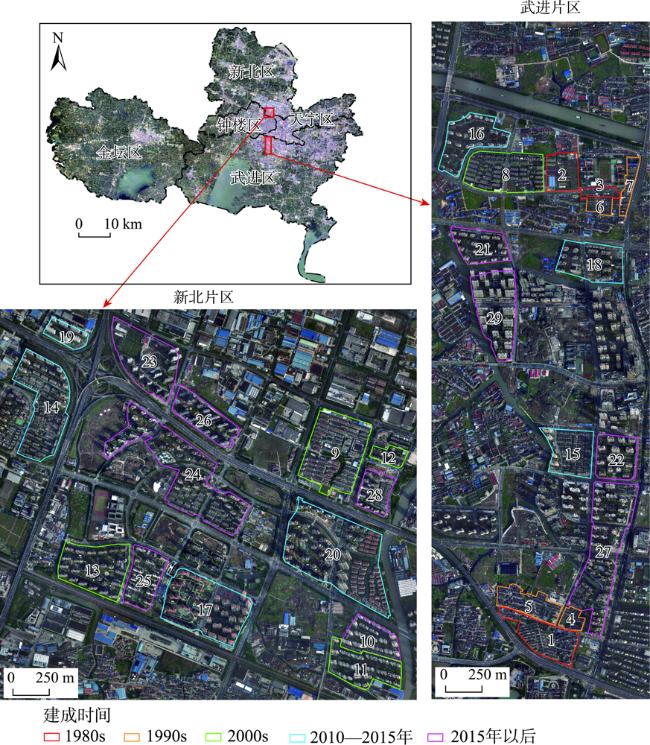
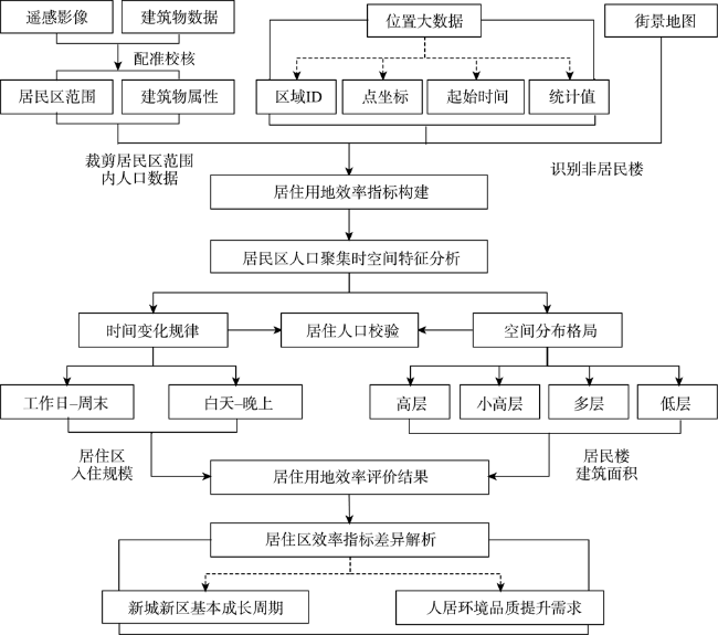
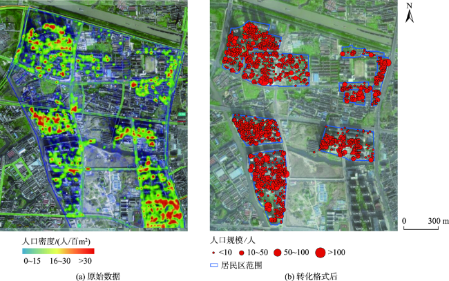
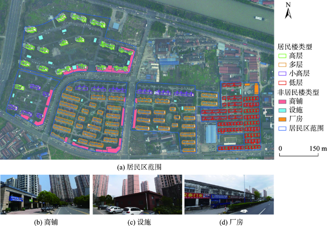
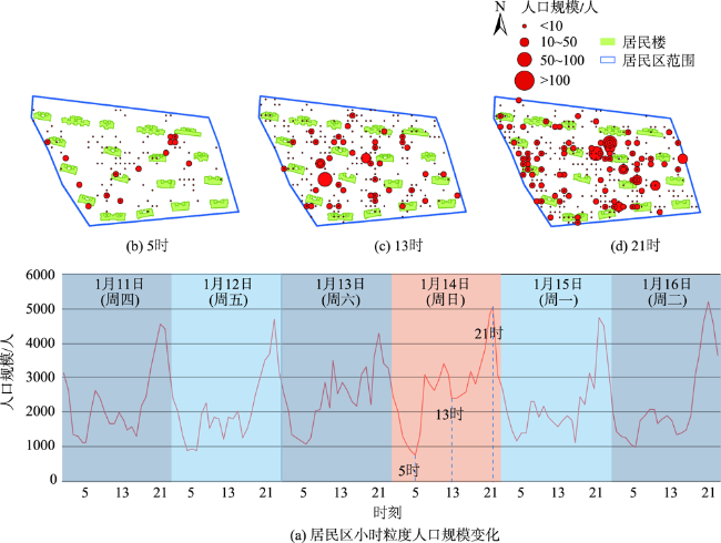
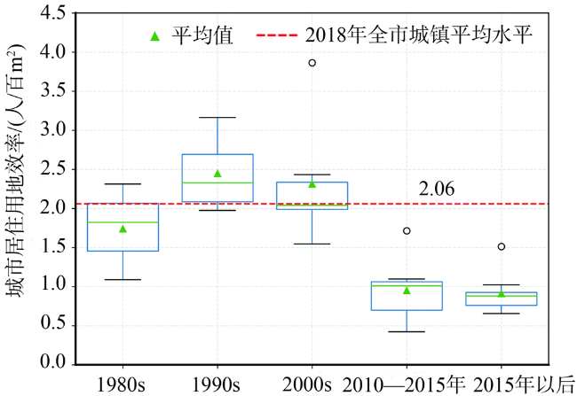
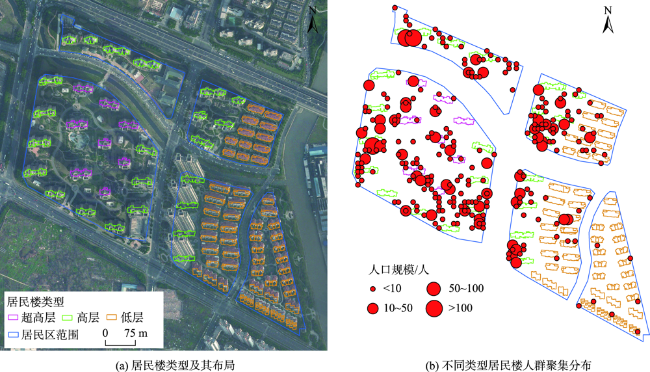
信息化赋能已经成为新时期国土空间规划的热点,但通过大数据整合进行国土空间利用评价研究仍有待探索。本文旨在借助腾讯位置大数据开展城市居住用地效率评价实证研究,综合运用多源地理空间数据,以居民区为评价单元构建居住用地效率指标,揭示常州市新城区不同居民区用地效率差异。结果表明:① 居民区范围内小时粒度的人口规模呈周期波动,峰值一般出现在21:00,符合城市居民昼出夜归的作息规律,且不同容积率水平的居民楼人口集聚度和规模值也存在预期性的差异;② 29个居民区按建成年份划分为1980s、1990s、2000s、2010—2015年、2015年以后共5组,各组效率指标平均值分别为1.74、2.45、2.31、0.95和0.91人/百m2,2010年之前建成的居民区明显高于2010年之后新建的,2010年以后建成的居民区低于全市2.06人/百m2的平均水平(2018年标准);③ 效率指标值低并非完全等同于集约用地水平低,常州市新城新区开发建设的成长周期、居民对提升人居环境品质的需求,都是导致不同居民区用地效率差异的原因。研究表明,位置大数据作为高精度的人口数据源,能够客观反映居民区人口聚集的时空间特征,基于位置大数据构建的城市居住用地效率指数能够为高质量国土空间利用分析提供新途径。在我国以人为本的城市化进程中,以位置大数据为代表的新型人口数据源将在国土空间规划中发挥愈加重要的作用。

袁源 , 毛磊 , 李洪庆 , 赵小风 . 基于位置大数据的城市居住用地效率指标构建及评价研究[J]. 地球信息科学学报, 2022 , 24(2) : 235 -248 . DOI: 10.12082/dqxxkx.2022.210239
Information empowerment to the territorial spatial planning has become a hot research field in the new era. However, research on territorial utilization evaluation using big data integration remains to be explored. The purpose of this paper is to carry out an empirical study on the efficiency assessment of residential land use in new urban area employing Tencent location-based big data. Assessment index of residential land use efficiency in each residential area have been proposed, supported by integration of multi-source geospatial data, to reveal the differences in land use efficiency among different residential areas in Changzhou city. The results show that, firstly, population size of hourly particle statistics within the residential area fluctuates periodically, reaching peak value at 21:00 generally, which is in line with the routine of daily going out and returning home for urban residents. There are also expected differences in population agglomeration degree and population size among residential buildings with different capacity rates. Secondly, the 29 residential areas are divided into five groups by year of construction, 1980s, 1990s, 2000s, 2010—2015, and post-2015. The average population size of efficiency index of group 1980s, 1990s, 2000s, 2010—2015, and post-2015 are 1.74, 2.45, 2.31, 0.95, and 0.91 per 100 m2, respectively. Index values of residential areas built before 2010 are significantly higher than those built after 2010. Furthermore, residential areas built after 2010 are lower than the average level (population size of 2.06 per 100 m2in year 2018) of the entire urban residential areas. Thirdly, it is suggested that lower results of efficiency index is not fully equal to poor level of intensive land use. The main reasons of diverse land use efficiency of residential areas constructed in different periods include the growth periodicity of new urban area development in Changzhou city, and urban residents' desire for better living environment to enhance their quality of habitation. Research shows that location-based big data, as a source of population data with high solution, could reflect the temporal and spatial characteristics of resident aggregations objectively. Index constructed to assess urban residential land efficiency using location-based big data is both innovative and scientific, which could provide a new way for the analysis of high-quality land space utilization. In conclusion, regularity recognition of behavior characteristics from urban residents can provide support for spatial policy formulation during the urbanization process based on "putting people first" policy in China. What's more, new data sources, represented by location-based big data in this paper, will play an important role in decision-making mechanism of territorial spatial planning.
表1 研究采用的数据源Tab. 1 Data sources employed in the study |
| 数据名称 | 年份 | 格式 | 来源 | 空间分辨率 | 属性与作用 |
|---|---|---|---|---|---|
| 遥感影像 | 2019 | TIF | 天地图影像 | 1 m | 居民区位置校核、空间配准 |
| 建筑物数据 | 2018 | SHAPEFILE | 业务主管部门(数据脱敏后提供) | 1:500 | 包括基底面积、层高等字段,用于计算居民楼建筑面积、居民区建筑密度和容积率等 |
| 百度街景地图数据 | 2019 | JPG | 百度地图 | - | 判读沿街建筑物用途并分类 |
| 腾讯位置大数据 | 2018 | JSON | 腾讯位置大数据平台 | 5 m | 包括区域ID、区域人数(pop)、起止时间(以小时为时间粒度)、所有点数据坐标(经纬度)及其权重值(weight)等字段,用于分析不同时刻居民区的人口规模及其空间分布 |
表2 案例地居民区用地效率评价结果Tab. 2 Assessment results of residential land utilization efficiency |
| 居民区编号 | 建成年份 | 用地效率/(人/百m2) | 建筑密度 | 建筑容积率 | 居民楼类型 |
|---|---|---|---|---|---|
| 1 | 1980s | 2.53 | 0.53 | 0.96 | L |
| 2 | 1986 | 1.09 | 0.33 | 0.64 | L |
| 3 | 1988 | 2.31 | 0.42 | 1.57 | L、D |
| 4 | 1990s | 2.12 | 0.44 | 0.86 | L |
| 5 | 1990s | 1.82 | 0.38 | 0.67 | L |
| 6 | 1990 | 1.97 | 0.61 | 1.44 | L |
| 7 | 1997 | 3.16 | 0.23 | 1.12 | D |
| 8 | 2001 | 2.43 | 0.21 | 1.13 | D、X |
| 9 | 2003 | 3.86 | 0.18 | 1.00 | D |
| 10 | 2008 | 1.54 | 0.15 | 2.37 | X、G |
| 11 | 2009 | 2.04 | 0.14 | 1.98 | D、X |
| 12 | 2009 | 2.03 | 0.17 | 2.57 | X、G |
| 13 | 2010 | 1.97 | 0.11 | 2.07 | X、G |
| 14 | 2012 | 1.71 | 0.19 | 2.00 | L、D、X、G |
| 15 | 2013 | 0.60 | 0.32 | 1.46 | L、G |
| 16 | 2014 | 1.03 | 0.09 | 2.72 | X、G |
| 17 | 2014 | 1.01 | 0.11 | 2.40 | G |
| 18 | 2015 | 0.80 | 0.14 | 4.28 | G |
| 19 | 2015 | 1.10 | 0.16 | 5.03 | G |
| 20 | 2015 | 0.42 | 0.18 | 2.77 | L、G、C |
| 21 | 2016 | 1.51 | 0.11 | 3.03 | G |
| 22 | 2016 | 1.02 | 0.14 | 3.27 | X、G |
| 23 | 2016 | 0.93 | 0.09 | 2.08 | G |
| 24 | 2016 | 0.91 | 0.16 | 2.68 | L、D、G |
| 25 | 2016 | 0.88 | 0.12 | 2.99 | X、G |
| 26 | 2016 | 0.75 | 0.07 | 1.96 | G |
| 27 | 2017 | 0.79 | 0.12 | 2.82 | L、G |
| 28 | 2017 | 0.65 | 0.12 | 2.05 | L、G |
| 29 | 2018 | 0.76 | 0.12 | 3.20 | G |
注:建筑密度为各类居民楼基底面积之和与居民区面积的比值;建筑容积率为各类居民楼建筑面积之和与居民区面积的比值;居民楼类型分别为L(低层)、D(多层)、X(小高层)、G(高层)、C(超高层)。 |
感谢傅文艳、何梦娇、李嘉明、闵柏霖4位同学为本文所做的部分数据处理工作。
| [1] |
邹晖, 罗小龙, 唐蜜, 等. 从住房建设透视巨型城市多中心发展——以北京为例[J]. 经济地理, 2019, 39(9):65-70.
[
|
| [2] |
林坚, 叶子君, 杨红. 存量规划时代城镇低效用地再开发的思考[J]. 中国土地科学, 2019, 33(9):1-8.
[
|
| [3] |
陈明星, 周园, 汤青, 等. 新型城镇化、居民福祉与国土空间规划应对[J]. 自然资源学报, 2020, 35(6):1273-1287.
[
|
| [4] |
杨建思, 柳帅, 王艳东, 等. 融合多源大数据的武汉城市空置区域评估与分析[J]. 地球信息科学学报, 2020, 22(5):997-1007.
[
|
| [5] |
王德, 李丹, 傅英姿. 基于手机信令数据的上海市不同住宅区居民就业空间研究[J]. 地理学报, 2020, 75(8):1585-1602.
[
|
| [6] |
|
| [7] |
杨振山, 苏锦华, 杨航, 等. 基于多源数据的城市功能区精细化研究——以北京为例[J]. 地理研究, 2021, 40(2):477-494.
[
|
| [8] |
柴彦威, 塔娜. 中国时空间行为研究进展[J]. 地理科学进展, 2013, 32(9):1362-1373.
[
|
| [9] |
|
| [10] |
|
| [11] |
钟炜菁, 王德. 基于居民行为周期特征的城市空间研究[J]. 地理科学进展, 2018, 37(8):1106-1118.
[
|
| [12] |
|
| [13] |
杜德林, 黄洁, 王姣娥. 基于多源数据的中国智慧城市发展状态评价[J]. 地球信息科学学报, 2020, 22(6):1294-1306.
[
|
| [14] |
申悦, 柴彦威. 基于GPS数据的北京市郊区巨型社区居民日常活动空间[J]. 地理学报, 2013, 68(4):506-516.
[
|
| [15] |
王波, 甄峰, 张浩. 基于签到数据的城市活动时空间动态变化及区划研究[J]. 地理科学, 2015, 35(2):151-160.
[
|
| [16] |
邹思聪, 张姗琪, 甄峰. 基于居民时空行为的社区日常活动空间测度及活力影响因素研究——以南京市沙洲、南苑街道为例[J]. 地理科学进展, 2021, 40(4):580-596.
[
|
| [17] |
王楠, 杜云艳, 易嘉伟, 等. 基于手机信令数据的北京市空间品质时空动态分析[J]. 地球信息科学学报, 2019, 21(1):86-96.
[
|
| [18] |
王德, 谢栋灿, 王灿, 等. 个体时空行为的规律性与可预测性研究——以上海市居民工作日活动为例[J]. 地理科学进展, 2021, 40(3):433-440.
[
|
| [19] |
|
| [20] |
|
| [21] |
|
| [22] |
罗桑扎西, 甄峰. 基于手机数据的城市公共空间活力评价方法研究——以南京市公园为例[J]. 地理研究, 2019, 38(7):1594-1608.
[
|
| [23] |
甄峰, 张姗琪, 秦萧, 等. 从信息化赋能到综合赋能:智慧国土空间规划思路探索[J]. 自然资源学报, 2019, 34(10):2060-2072.
[
|
| [24] |
钟炜菁, 王德, 谢栋灿, 等. 上海市人口分布与空间活动的动态特征研究——基于手机信令数据的探索[J]. 地理研究, 2017, 36(5):972-984.
[
|
| [25] |
席广亮, 甄峰. 基于大数据的城市规划评估思路与方法探讨[J]. 城市规划学刊, 2017(1):56-62.
[
|
| [26] |
柴彦威, 刘伯初, 刘瑜, 等. 基于多源大数据的城市体征诊断指数构建与计算——以上海市为例[J]. 地理科学, 2018, 38(1):1-10.
[
|
| [27] |
孔宇, 甄峰, 张姗琪, 等. 基于多源数据的国土空间高质量利用评价思路[J]. 中国土地科学, 2020, 34(5):115-124.
[
|
| [28] |
秦萧, 甄峰, 李亚奇, 等. 国土空间规划大数据应用方法框架探讨[J]. 自然资源学报, 2019, 34(10):2134-2149.
[
|
| [29] |
刘瑜, 姚欣, 龚咏喜, 等. 大数据时代的空间交互分析方法和应用再论[J]. 地理学报, 2020, 75(7):1523-1538.
[
|
| [30] |
冯健, 钟奕纯. 基于居住环境的常州城市居民生活质量空间结构[J]. 地理学报, 2020, 75(6):1237-1255.
[
|
| [31] |
|
| [32] |
吴中元, 许捍卫, 胡钟敏. 基于腾讯位置大数据的精细尺度人口空间化——以南京市江宁区秣陵街道为例[J]. 地理与地理信息科学, 2019, 35(6):61-65.
[
|
| [33] |
袁源, 张小林, 李红波, 等. 基于位置大数据的村域尺度多功能性评价——以苏州市为例[J]. 自然资源学报, 2021, 36(3):674-687.
[
|
| [34] |
许珺, 徐阳, 胡蕾, 等. 基于位置大数据的青藏高原人类活动时空模式[J]. 地理学报, 2020, 75(7):1406-1417.
[
|
| [35] |
|
| [36] |
|
| [37] |
江苏省统计局. 江苏统计年鉴2019[EB/OL]. http://tj.jiangsu.gov.cn/col/col76362/index.html,2021-06-13.
[ Jiangsu Provincial Statistical Bureau. Jiangsu Statistical Yearbook 2019. http://tj.jiangsu.gov.cn/col/col76362/index.html,2021-06-13.
|
| [38] |
沈娉, 张尚武, 潘鑫. 我国城市新区空间绿色发展的规律和经验研究[J]. 城市规划学刊, 2020(4):28-36.
[
|
| [39] |
常州市统计局. 常州统计年鉴2019[EB/OL]. http://tjj.changzhou.gov.cn/html/tjj/2019/OEJCMFCP_1106/16055
[ Changzhou Prefectural Statistical Bureau. Changzhou Statistical Yearbook 2019[EB/OL]. http://tjj.changzhou.gov.cn/html/tjj/2019/OEJCMFCP_1106/16055.html, 2021-06-13.
|
| [40] |
赵小风, 楼佳俊, 黄贤金, 等. 城市土地利用效率研究进展[J]. 现代城市研究, 2017(6):2-8.
[
|
| [41] |
李德仁. 论时空大数据的智能处理与服务[J]. 地球信息科学学报, 2019, 21(12):1825-1831.
[
|
| [42] |
|
| [43] |
马超, 孙群, 徐青, 等. 自发地理信息可信度及其评价[J]. 地球信息科学学报, 2016, 18(10):1305-1311.
[
|
| [44] |
崔晓临, 张佳蓓, 吴锋, 等. 基于多源数据融合的北京市人口时空动态分析[J]. 地球信息科学学报, 2020, 22(11):2199-2211.
[
|
| [45] |
朱守杰, 杜世宏, 李军, 等. 融合多源空间数据的城镇人口分布估算[J]. 地球信息科学学报, 2020, 22(8):1607-1616.
[
|
| [46] |
|
| [47] |
王佳文, 叶裕民, 董珂. 从效率优先到以人为本——基于“城市人理论”的国土空间规划价值取向思考[J]. 城市规划学刊, 2020(6):19-26.
[
|
/
| 〈 |
|
〉 |