
国土空间规划视角下的城镇开发边界划定和空间管控体系构建
|
陈 霆(1997— ),男,福建莆田人,硕士生,主要从事国土空间规划、地理模拟研究。E-mail: chenting49365@163.com |
收稿日期: 2021-09-15
要求修回日期: 2021-11-21
网络出版日期: 2022-04-25
基金资助
中国科学院战略性先导科技专项(A类XDA23100502)
福建省科技厅引导性项目(2017Y0055)
版权
Delimitation of Urban Development Boundary and Construction of Space Control System from the Perspective of Territorial Spatial Planning
Received date: 2021-09-15
Request revised date: 2021-11-21
Online published: 2022-04-25
Supported by
The Strategic Priority Research Program of the Chinese Academy of Sciences(A类XDA23100502)
Science and Technology Agency of Fujian Province(2017Y0055)
Copyright
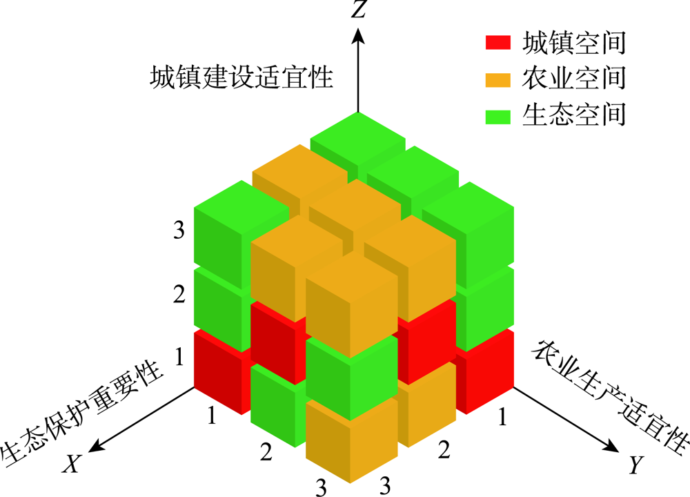
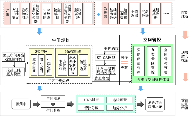
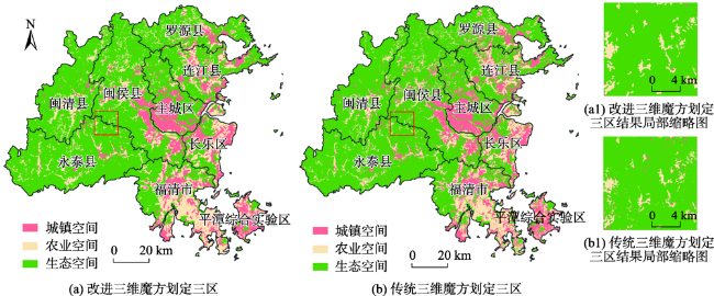
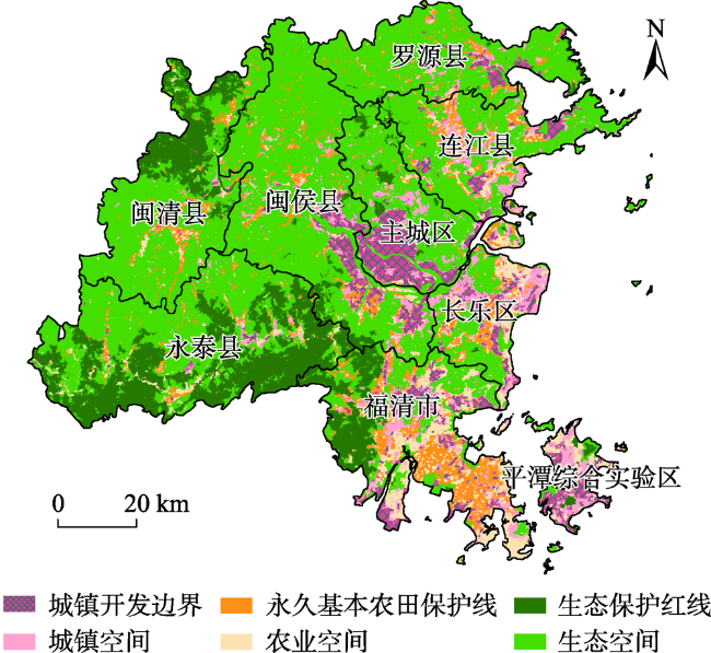
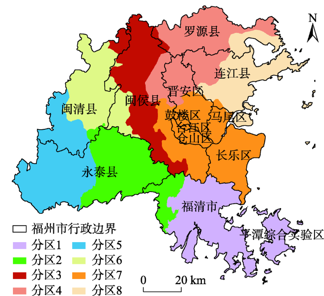
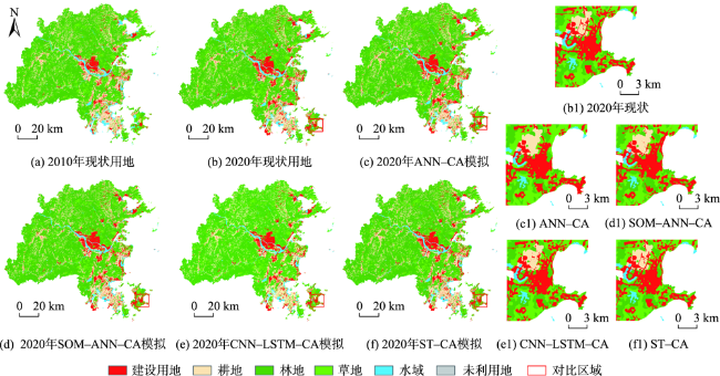
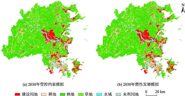
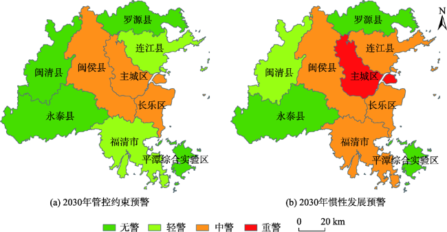
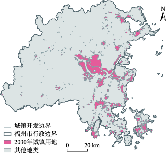
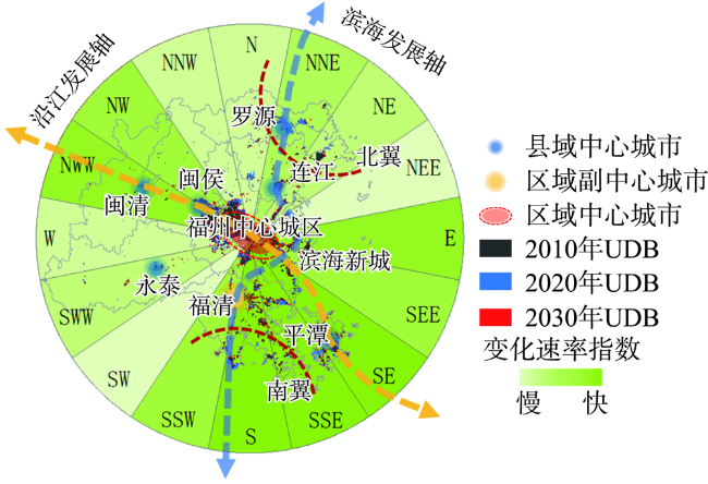
新时期国土空间规划背景下,科学合理地划定城镇开发边界,建立健全的国土空间用途管制制度是有序引导国土空间各类开发保护行为的重要举措。本文以福州市为例,构建了一种全域多维度国土空间管控体系,将其管控约束条件嵌入未来土地利用格局模拟中。同时,顾及区域空间异质性和时空依赖性,设计了一种服务于城镇开发边界划定的集成地理分区策略、深度学习技术、FLUS模型功能模块的时空元胞自动机ST-CA(Spatio-Temporal Cellular Automata)模型。基于已有成果集成三区三线,开展“划管结合”思维下的空间管控应用研究。结果表明:① 顾及区域空间异质性和时空依赖性的ST-CA模型可以有效提高土地利用变化模拟精度(OA指标从95.95%提升至98.34%),实现更为真实、准确的地理模拟过程;② 地理模拟过程中嵌入管控约束条件,可引导城镇、农业和生态3类空间合理布局且规模可控,基于模拟结果划定的城镇开发边界能有效避开规划保护用地;③ 未来模拟预测结果结合管控预警值可看出,福州市主城区及周边区县的城镇扩张形势比较严峻,未来亟需对福州市国土空间格局进行合理调控;④ 边界变化趋势特征表明划定结果与福州市的远景发展规划布局一致,符合区域发展诉求,国土空间格局呈现多轴化发展趋势。研究结果可为福州市国土空间开发保护行为提供科学谋划,为国土空间管控及优化提供实践参考依据。
陈霆 , 徐伟铭 , 吴升 , 刘洁 . 国土空间规划视角下的城镇开发边界划定和空间管控体系构建[J]. 地球信息科学学报, 2022 , 24(2) : 263 -279 . DOI: 10.12082/dqxxkx.2022.210552
Under the background of territorial spatial planning in the new period, delimiting the urban development boundary scientifically and reasonably and establishing a sound territorial space use control system are important measures to guide all kinds of territorial space development and protection. Taking Fuzhou City as an example, this paper constructs a global multi-dimensional territorial space control system. Management and control constraints are embedded in the future land use pattern simulation. At the same time, considering the regional spatial heterogeneity and spatial-temporal dependence, this paper designs the Spatial-temporal Cellular Automata (ST-CA) model which integrates geographical partition strategy, deep learning technology, and the functional module of FLUS model to delimit the urban development boundary. Based on the existing achievements, this study integrates three zones and three lines to carry out the application research of spatial management and control under the thinking of "combination of planning and control". The results show that: (1) The ST-CA model considering regional spatial heterogeneity and spatial-temporal dependence can effectively improve the accuracy of land use change simulation and achieve a more realistic and accurate geographical simulation process. The overall accuracy of the model increased from 95.95% to 98.34%; (2) Control constraints are embedded in the process of geographical simulation, which can guide the rational layout and controllable scale of urban, agricultural, and ecological spaces. Delimitation of urban development boundary based on simulation results can effectively avoid occupation on protected land; (3) The future simulation results combined with the control early warning value show that the urban expansion situation in the main urban area and surrounding districts and counties of Fuzhou City is relatively severe. In the future, it is urgent to reasonably regulate the territorial space pattern of Fuzhou City; (4) The characteristics of boundary change trend show that the delimitation results are consistent with the long-term development planning of Fuzhou City, which is in line with regional development demands. The territorial space pattern presents a multi-axis development trend. The research results can provide scientific planning for the development and protection of territorial space and practical reference for territorial space control and optimization in Fuzhou City.
表1 研究区现状空间功能用地Tab. 1 Current spatial functional land in study area |
| 空间类型 | 分类依据 | 一级类 | 二级类 |
|---|---|---|---|
| 城镇空间 | 从事城镇建设和发展经济的区域 | 城乡、工矿、居民用地 | 城镇用地 |
| 其他建设用地等 | |||
| 农业空间 | 提供农产品和农村生活为主导功能的区域 | 农业生产用地 | 农村居民点 |
| 旱地 | |||
| 水田 | |||
| 生态空间 | 具有自然属性,提供生态产品服务功能的区域 | 林地 | 有林地、灌木林、疏林地等 |
| 草地 | 天然草地、其他草地等 | ||
| 水域 | 河流、湖泊、滩涂、滩地等 | ||
| 未利用地 | 沙地、裸土地、沼泽地等 |
表2 土地利用变化驱动因子相关信息Tab. 2 Information of driving factors for land use change |
| 类型 | 编号 | 驱动因子 | 因子说明 |
|---|---|---|---|
| 自然环境 | X1 | 高程 | 代表该空间单元的高程 |
| X2 | 坡度 | 代表该空间单元的陡缓程度 | |
| X3 | 植被覆盖度 | 代表空间单元森林资源和绿化水平 | |
| 区位条件 | X4 | 距区县中心距离 | 代表该空间单元到其最近区县中心的距离 |
| X5 | 距机场距离 | 代表该空间单元到其最近机场的距离 | |
| X6 | 距港口距离 | 代表该空间单元到其最近港口的距离 | |
| X7 | 距火车站距离 | 代表该空间单元到其最近火车站的距离 | |
| X8 | 距公交站距离 | 代表该空间单元到其最近公交站的距离 | |
| X9 | 距铁路距离 | 代表该空间单元到其最近铁路的距离 | |
| X10 | 距公路距离 | 代表该空间单元到其最近公路的距离 | |
| X11 | 距河流距离 | 代表该空间单元到其最近河流的距离 | |
| 社会经济 | X12 | GDP | 代表该空间单元的GDP水平 |
| X13 | 人口密度 | 代表该空间单元的人口分布状况 | |
| X14 | 夜间灯光指数 | 代表该空间单元的城市发展情况 | |
| 政策规划 | X15 | 规划空间布局 | 代表规划布局对该空间单元的引导 |
| X16 | 规划轨道交通 | 代表该空间单元到其最近轨道交通的距离 | |
| X17 | 规划产业结构 | 代表产业结构布局对该空间单元的引导 |
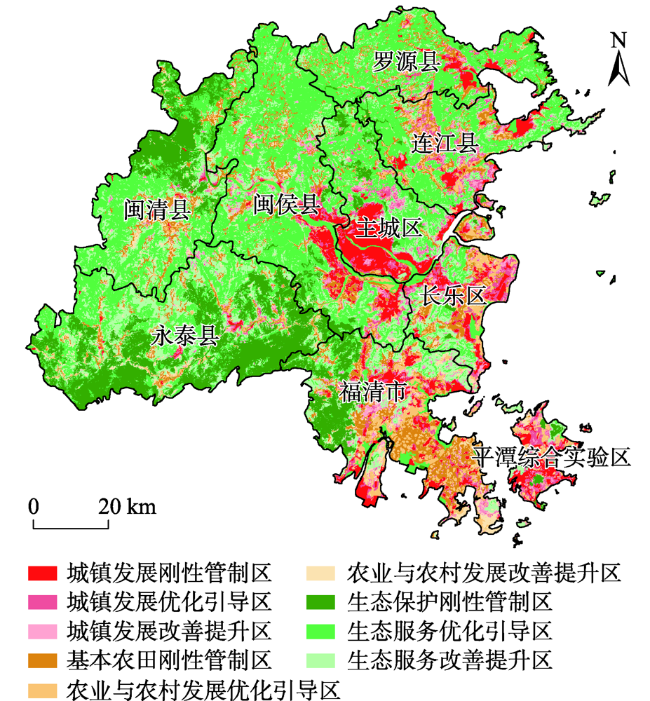
表3 “3+3+3”国土空间管控分区[26]Tab. 3 Territorial space use control zoning of “3+3+3” |
| 空间功能 | 管控分区 |
|---|---|
| 城镇指向 | 城镇开发边界刚性管制区 |
| 城镇发展优化引导区 | |
| 城镇发展改善提升区 | |
| 农业指向 | 基本农田刚性管制区 |
| 农业与农村发展优化引导区 | |
| 农业与农村发展改善提升区 | |
| 生态指向 | 生态保护红线刚性管制区 |
| 生态服务优化引导区 | |
| 生态服务改善提升区 |
表4 福州市空间管控预警指标Tab. 4 Early warning index for space control in Fuzhou city |
| 目标层 | 准则层 | 权重 | 指标层 | 权重 |
|---|---|---|---|---|
| 空间管控预警 | 违法规模 | 0.2808 | 建设用地占用生态保护区面积 | 0.1245 |
| 建设用地占用基本农田面积 | 0.1088 | |||
| 建设用地占用耕地面积 | 0.0475 | |||
| 管控强度 | 0.3397 | 城镇空间开发保护强度 | 0.0666 | |
| 农业空间开发保护强度 | 0.1204 | |||
| 生态空间开发保护强度 | 0.1269 | |||
| 建设用地扩展强度指数 | 0.0258 | |||
| 形态布局 | 0.1404 | 聚集指数 | 0.0436 | |
| 建设用地紧凑度 | 0.0693 | |||
| 蔓延度指数 | 0.0275 | |||
| 自然环境 | 0.2390 | 景观形状指数 | 0.0231 | |
| 建设用地平均生态敏感性指数 | 0.0978 | |||
| 建设用地平均高程指数 | 0.0489 | |||
| 建设用地平均坡度指数 | 0.0692 |
表5 数据清单说明Tab. 5 Description of data list |
| 类型 | 数据名称 | 时间/年 | 数据来源 |
|---|---|---|---|
| 基础地理数据 | 区县中心、交通站点、铁路 | 2015 | 1:25万基础地理数据库(www.webmap.cn) |
| 高速公路、一般公路、河流 | |||
| 自然环境数据 | 土壤数据 | 1995 | 资源环境数据云平台(http://www.resdc.cn/) |
| DEM | 2015 | 地理空间数据云网站(http://www.gscloud.cn/) | |
| 植被指数 | 2010—2020 | 资源环境数据云平台(http://www.resdc.cn/) | |
| 遥感影像数据 | 遥感影像 | 2010—2020 | 地理空间数据云网站(http://www.gscloud.cn/) |
| 土地利用数据 | 土地利用数据 | 2010—2020 | 遥感影像解译 |
| 社会经济数据 | GDP、人口密度 | 2010—2015 | 资源环境数据云平台(http://www.resdc.cn/) |
| 夜间灯光数据 | 2013 | 资源环境数据云平台(http://www.resdc.cn/) | |
| 政策规划数据 | 规划空间布局、轨道交通、 | 福州市自然资源和规划局 | |
| 产业结构、控制线成果 | |||
| 气象数据集 | 年均降水、年均风速 | 1981—2010 | 中国气象数据网(http://www.cma.gov.cn/) |
| 月均湿度、月均气温 |
表6 空间冲突排列组合Tab. 6 Permutation and combination of space conflict |
| 冲突类型 | 冲突模式 |
|---|---|
| 生态优势区 | 高-中/低-中/低;中-低-低 |
| 农业优势区 | 中/低-高-中/低;低-中-低 |
| 城镇优势区 | 中/低-中/低-高;低-低-中 |
| 强冲突区 | 高-高-高;高-中/低-高; 中/低-高-高 |
| 中冲突区 | 高-高-中/低;中-中-中; 中-低-中;低-中-中 |
| 弱冲突区 | 低-低-低;中-中-低 |
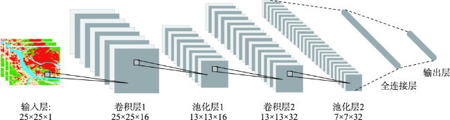
表7 不同模型组合模拟结果精度对比Tab. 7 Comparison of simulation accuracy of different model combinations |
| 模型 | OA/% | Kappa | FoM |
|---|---|---|---|
| ANN-CA | 95.95 | 0.9321 | 0.3999 |
| SOM-ANN-CA | 96.71 | 0.9448 | 0.4648 |
| CNN-LSTM-CA | 97.88 | 0.9645 | 0.5552 |
| ST-CA | 98.34 | 0.9722 | 0.6914 |
| [1] |
张晓玲, 吕晓. 国土空间用途管制的改革逻辑及其规划响应路径[J]. 自然资源学报, 2020, 35(6):1261-1272.
[
|
| [2] |
王成新, 窦旺胜, 程钰, 等. 快速城市化阶段济南城市空间扩展及驱动力研究[J]. 地理科学, 2020, 40(9):1513-1521.
[
|
| [3] |
|
| [4] |
谭荣辉, 刘耀林, 刘艳芳, 等. 城市增长边界研究进展——理论模型、划定方法与实效评价[J]. 地理科学进展, 2020, 39(2):327-338.
[
|
| [5] |
高晓路, 吴丹贤, 周侃, 等. 国土空间规划中城镇空间和城镇开发边界的划定[J]. 地理研究, 2019, 38(10):2458-2472.
[
|
| [6] |
张佶, 李亚洲, 刘冠男, 等. 寻求强控与发展的平衡——空间规划央地协同治理的国际经验与启示[J]. 国际城市规划, 2021, 36(4):82-90.
[
|
| [7] |
林坚, 乔治洋, 叶子君. 城市开发边界的“划”与“用”——我国14个大城市开发边界划定试点进展分析与思考[J]. 城市规划学刊, 2017(2):37-43.
[
|
| [8] |
钟珊, 赵小敏, 郭熙, 等. 基于空间适宜性评价和人口承载力的贵溪市中心城区城市开发边界的划定[J]. 自然资源学报, 2018, 33(5):801-812.
[
|
| [9] |
|
| [10] |
刘阳, 李志英, 龙晔, 等. 基于生态适宜性的昆明城市空间增长边界研究[J]. 长江流域资源与环境, 2020, 29(7):1555-1565.
[
|
| [11] |
易丹, 赵小敏, 郭熙, 等. 基于生态敏感性评价和CA-Markov模拟的平原型城市开发边界划定——以南昌市为例[J]. 应用生态学报, 2020, 31(1):208-218.
[
|
| [12] |
龙瀛, 韩昊英, 毛其智. 利用约束性CA制定城市增长边界[J]. 地理学报, 2009, 64(8):999-1008.
[
|
| [13] |
陈伟强, 潘元庆, 马月红, 等. 基于约束性CA模型的城市开发边界划定方法[J]. 农业工程学报, 2017, 33(4):278-284.
[
|
| [14] |
|
| [15] |
|
| [16] |
艾东, 王朔, 张荣群, 等. 基于多智能体模型的银川平原土地利用情景模拟[J]. 农业机械学报, 2017, 48(S1):262-270.
[
|
| [17] |
|
| [18] |
吴欣昕, 刘小平, 梁迅, 等. FLUS-UGB多情景模拟的珠江三角洲城市增长边界划定[J]. 地球信息科学学报, 2018, 20(4):532-542.
[
|
| [19] |
|
| [20] |
|
| [21] |
|
| [22] |
|
| [23] |
黄征学, 蒋仁开, 吴九兴. 国土空间用途管制的演进历程、趋势与政策创新[J]. 中国土地科学, 2019, 33(6):1-9.
[
|
| [24] |
樊杰. 中国主体功能区划方案[J]. 地理学报, 2015, 70(2):186-201.
[
|
| [25] |
程永辉, 刘科伟, 赵丹, 等. “多规合一”下城市开发边界划定的若干问题探讨[J]. 城市发展研究, 2015, 22(7):52-57.
[
|
| [26] |
岳文泽, 王田雨, 甄延临. “三区三线”为核心的统一国土空间用途管制分区[J]. 中国土地科学, 2020, 34(5):52-59,68.
[
|
| [27] |
中华人民共和国自然资源部. 资源环境承载能力和国土空间开发适宜性评价指南(试行)[EB/OL]. http://gi.mnr.gov.cn/202001/t20200121_2498502.html,2020-1-19.
[ Ministry of Natural Resources of the People's Republic of China. Guidelines for evaluating the carrying capacity of resources and environment and the suitability of territorial space development(trial implementation) [EB/OL]. http://gi.mnr.gov.cn/202001/t20200121_2498502.html,2020-1-19.
|
| [28] |
王千. 河北省建设用地集约利用多维度综合管控分区研究[J]. 中国人口·资源与环境, 2017, 27(S2):136-139.
[
|
| [29] |
《城乡建设用地竖向规划规范》(CJJ 83—2016). 中华人民共和国住房和城乡建设部, 2016.
[ Code for Vertical Planning on urban and rural development land (CJJ 83-2016), Ministry of Housing and Urban-Rural Development of the People's Republic of China, 2016. ]
|
| [30] |
姜博, 王媛, 魏超, 等. 城市土地利用扩展的驱动因素与空间扩展模式研究[J]. 干旱区资源与环境, 2014, 28(7):1-6.
[
|
| [31] |
张世伟, 魏璐瑶, 金星星, 等. 基于FLUS-UGB的县域土地利用模拟及城镇开发边界划定研究[J]. 地球信息科学学报, 2020, 22(9):1848-1859.
[
|
| [32] |
|
| [33] |
张顺, 龚怡宏, 王进军. 深度卷积神经网络的发展及其在计算机视觉领域的应用[J]. 计算机学报, 2019, 42(3):453-482.
[
|
| [34] |
|
| [35] |
|
| [36] |
宋戈, 连臣. 黑龙江省耕地资源安全预警分析及预警系统的构建[J]. 农业工程学报, 2012, 28(6):247-252.
[
|
| [37] |
李灿, 张凤荣, 王枫, 等. 快速城镇化过程中建设用地空间安全预警分析[J]. 中国土地科学, 2015(6):49-56,2,97.
[
|
/
| 〈 |
|
〉 |

