
基于DCT-PLS算法的MODIS LST缺值填补方法研究
|
刘恒孜(1997— ),男,河南许昌人,硕士生,主要从事遥感地学分析与计算研究。E-mail: liuhengzi18@mails.ucas.ac.cn |
收稿日期: 2021-05-10
要求修回日期: 2021-07-05
网络出版日期: 2022-04-25
基金资助
国家自然科学基金项目(41971312)
南方海洋科学与工程广东省实验室(广州)人才团队引进重大专项(GML2019ZD0301)
版权
Research on Gaps Filling of MODIS LST based on DCT-PLS
Received date: 2021-05-10
Request revised date: 2021-07-05
Online published: 2022-04-25
Supported by
National Natural Science Foundation of China(41971312)
Key Special Project for Introduced Talents Team of Southern Marine Science and Engineering Guangdong Laboratory (Guangzhou)(GML2019ZD0301)
Copyright
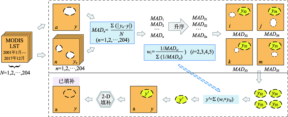
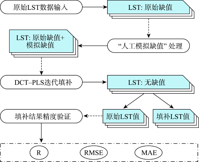
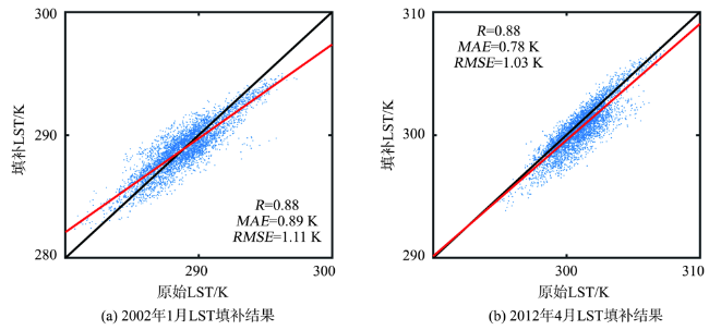
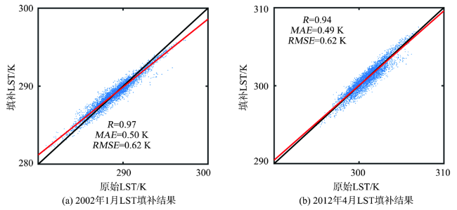
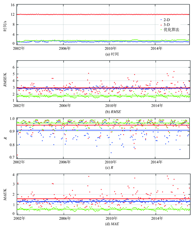
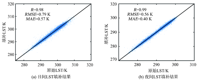
受云层、传感器误差等因素影响,中分辨率成像光谱仪(MODIS)获取的地表温度产品(LST)在时间和空间上存在大量缺失数据,严重影响了基于时间序列数据的分析与应用。本文引进一种基于离散余弦变换与惩罚最小二乘的多维数据快速平滑方法(DCT-PLS),利用数据集自身的时间和空间信息填补缺值。本文在粤港澳大湾区开展实证研究,将DCT-PLS算法用于填补该地区2001年1月—2017年12月的月值MODIS LST数据缺值,并引入人工模拟缺值对算法进行误差分析与精度验证。算法误差分析结果表明,填补误差主要来源于三维算法对数据集中有偏LST时间信息的使用,并因此产生显著高估或低估的填补结果。基于此,本文提出了利用MODIS LST数据集自身时间序列信息自动计算获取有效辅助LST信息的优化策略,从而实现填补算法计算效率和精度的提升:平均计算时间从12.0 s提高至1.7 s,平均R从0.94提高至0.97,平均RMSE从1.94 K提高至0.74 K(相较于三维算法)。在大湾区的填补结果表明(日间结果:R=0.98、RMSE=0.79 K;夜间结果:R=0.99、RMSE=0.56 K),优化后的DCT-PLS算法可以快速鲁棒地填补MODIS LST月值数据产品中的缺值,并且具有稳定性强、不依赖外部数据集的计算特性,能够适应长时间序列MODIS LST缺值填补。
刘恒孜 , 吕宁 , 姜侯 , 姚凌 . 基于DCT-PLS算法的MODIS LST缺值填补方法研究[J]. 地球信息科学学报, 2022 , 24(2) : 378 -390 . DOI: 10.12082/dqxxkx.2022.210257
Affected by cloud layer, sensor error, and other factors, there are large area of data gaps in time and space of Land Surface Temperature (LST) products acquired by Moderate-resolution Imaging Spectroradiometer (MODIS), which seriously affects the analysis and application of LST data set. In this paper, a fully automatic smoothing algorithm for filling MODIS LST data sets is introduced. Based on a Penalized Least Squares (PLS) method, the algorithm allows fast smoothing of data in one and more dimensions by means of the Discrete Cosine Transform (DCT). By optimizing smoothing parameters, the DCT-PLS algorithm is a fast multidimensional data smoothing method, which uses the spatial and temporal information of LST data set to fill data gaps. This study carries out an empirical study in Guangdong-Hong Kong-Macao Greater Bay Area (GBA). The DCT-PLS algorithm is used to fill data gaps of monthly MODIS LST data set from January 2001 to December 2017 in this area. To analyze its performance, the error analysis and accuracy verification of the algorithm are performed by introducing artificial simulation data gaps. The results of error analysis show that errors in gap filling are mainly due to the use of biased LST time information in data set, which causes significantly overestimation or underestimation in filling results. In response to this problem, an optimized DCT-PLS algorithm is proposed to automatically obtain effective auxiliary LST layers from the time series of MODIS LST and provide unbiased temporal information. Meanwhile, the three-dimensional algorithm is changed to two-dimensional space to reduce computing consumption by transforming auxiliary temporal information into spatial information. The results of accuracy verification on the optimized DCT-PLS algorithm show that the computational efficiency and accuracy are optimized simultaneously. The average computing time decreases from 12.0s to 1.7s, average R increases from 0.94 to 0.97, and average RMSE decreases from 1.94 K to 0.74 K (compared with the three-dimensional algorithm). The optimized DCT-PLS algorithm is applied in GBA. The accuracy of gap filling of monthly MODIS LST data set from January 2001 to December 2017 is R=0.98 and RMSE=0.79 K in daytime, and R=0.99 and RMSE=0.56 K in nighttime. The results of accuracy verification in GBA show that the accuracy of gap filling is not affected by heterogeneous surface. The optimized DCT-PLS algorithm transforms the MODIS LST data in the time domain and frequency domain to two-dimensional space, and retains high-frequency information to fill data gaps. It is a fast and robust method for gap filling, which is completely independent of external auxiliary data sets, enabling gap filling on long-time sequence MODIS LST data set.
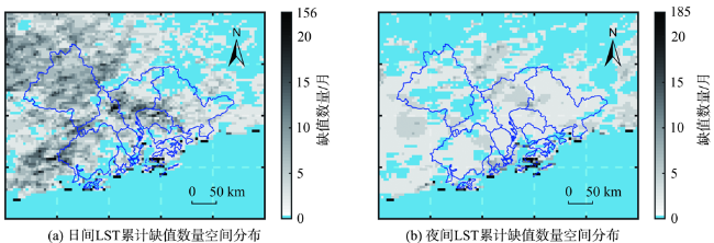
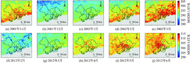
图2 粤港澳大湾区MODIS LST累计(2001年1月—2017年12月)缺值数量空间分布注:蓝色线为叠加的粤港澳行政区划界限。该图基于自然资源部标准地图服务网站下载的审图号为GS(2019)4342号的标准 地图制作,底图无修改。 Fig. 2 Spatial distribution of cumulative missing pixels of MODIS LST in GBA from 2001.1 to 2017.12 |
表1 粤港澳大湾区不同土地利用类型MODIS LST累计(2001年1月—2017年12月)缺值面积占比Tab. 1 Proportion of cumulative missing area of MODIS LST for different land covers in GBA from 2001.1 to 2017.12 (%) |
| 土地利用类型 | 缺失面积占比(日间) | 缺失面积占比(夜间) |
|---|---|---|
| 林地 | 83.12 | 76.18 |
| 灌木林 | 83.65 | 73.08 |
| 草地 | 85.71 | 82.14 |
| 耕地 | 87.14 | 87.14 |
| 城市区域 | 90.95 | 87.65 |
表2 粤港澳大湾区2001年1月—2017年12月日间和夜间LST缺值填补结果在不同土地利用类型中的精度Tab. 2 Accuracy evaluation of day-time and night-time LST filling results for different land covers in GBA from 2001.1 to 2017.12 |
| 土地覆盖类型 | RMSE/K | R | MAE/K | |||
|---|---|---|---|---|---|---|
| 日间 | 夜间 | 日间 | 夜间 | 日间 | 夜间 | |
| 林地 | 0.75 | 0.55 | 0.98 | 0.99 | 0.57 | 0.39 |
| 灌木林 | 0.78 | 0.58 | 0.97 | 0.99 | 0.58 | 0.41 |
| 草地 | 0.79 | 0.57 | 0.98 | 0.99 | 0.58 | 0.42 |
| 耕地 | 0.79 | 0.60 | 0.98 | 0.99 | 0.56 | 0.43 |
| 城市区域 | 0.85 | 0.67 | 0.98 | 0.99 | 0.59 | 0.45 |
| [1] |
闫李月, 李洪忠, 韩宇, 等. MODIS与Landsat 8地表温度融合拼接——以粤港澳大湾区为例[J]. 热带地理, 2019, 39(5):689-700.
[
|
| [2] |
战川, 唐伯惠, 李召良. 近地表大气逆温条件下的地表温度遥感反演与验证[J]. 遥感学报, 2018, 22(1):28-37.
[
|
| [3] |
李召良, 段四波, 唐伯惠, 等. 热红外地表温度遥感反演方法研究进展[J]. 遥感学报, 2016, 20(5):899-920.
[
|
| [4] |
管延龙, 王让会, 李成, 等. 基于MODIS数据的天山区域地表温度时空特征[J]. 应用生态学报, 2015, 26(3):681-688.
[
|
| [5] |
刘志武, 党安荣, 雷志栋, 等. 利用ASTER遥感数据反演陆面温度的算法及应用研究[J]. 地理科学进展, 2003, 22(5):507-514,544.
[
|
| [6] |
魏然, 单杰. 城市地表温度影像时空融合方法研究[J]. 武汉大学学报·信息科学版, 2018, 43(3):428-435.
[
|
| [7] |
|
| [8] |
于晓静, 刘焕军, 曲长祥, 等. 基于MODIS数据的黑龙江省黑土带地温空间格局分析[J]. 水土保持研究, 2012, 19(2):66-70,287.
[
|
| [9] |
|
| [10] |
|
| [11] |
周芳成, 宋小宁, 李召良. 地表温度的被动微波遥感反演研究进展[J]. 国土资源遥感, 2014, 26(1):1-7.
[
|
| [12] |
|
| [13] |
柯灵红, 王正兴, 宋春桥, 等. 青藏高原东北部MODIS LST时间序列重建及与台站地温比较[J]. 地理科学进展, 2011, 30(7):819-826.
[
|
| [14] |
|
| [15] |
柯灵红, 王正兴, 宋春桥, 等. 青藏高原东北部MODIS地表温度重建及其与气温对比分析[J]. 高原气象, 2011, 30(2):277-287.
[
|
| [16] |
|
| [17] |
韩晓勇, 韩玲, 戚鹏程. 秦巴山区MODISLST时序数据重建及特征分析[J]. 地理与地理信息科学, 2016, 32(1):71-77.
[
|
| [18] |
|
| [19] |
|
| [20] |
|
| [21] |
臧琳, 宋冬梅, 单新建, 等. 基于被动微波与时空联合算法的云下像元LST重建[J]. 遥感技术与应用, 2016, 31(4):764-772.
[
|
| [22] |
|
| [23] |
|
| [24] |
|
| [25] |
|
| [26] |
|
| [27] |
|
| [28] |
|
| [29] |
张桂欣, 郝振纯, 祝善友, 等. AMSR2缺失数据重建及其土壤湿度反演精度评价[J]. 农业工程学报, 2016, 32(20):137-143.
[
|
| [30] |
|
| [31] |
张慧娴. 中国农田植被时空变化特征及其气候影响因子分析[D]. 南京:南京信息工程大学, 2018.
[
|
| [32] |
|
| [33] |
肖江洪. 高频地波雷达海流数据处理方法研究[D]. 武汉:武汉大学, 2017.
[
|
| [34] |
彭晓琳. 全球卫星臭氧产品的时空重建研究[D]. 武汉:武汉大学, 2017.
[
|
/
| 〈 |
|
〉 |

