
雅鲁藏布江中部流域土地沙化遥感识别
|
詹琪琪(1998— ),女,四川广安人,硕士生,主要从事土地沙化遥感监测研究。E-mail: zhanqq@imde.ac.cn |
收稿日期: 2021-03-17
要求修回日期: 2021-04-22
网络出版日期: 2022-04-25
基金资助
第二次青藏高原综合科学考察研究(2019QZKK0404)
国家自然科学基金项目(42071349)
四川省科技计划资助(2020JDJQ0003)
中国科学院“西部之光”西部青年学者A类(2016333)
版权
Identification of Sandy Land in the Midstream of the Yarlung Zangbo River
Received date: 2021-03-17
Request revised date: 2021-04-22
Online published: 2022-04-25
Supported by
The Second Tibetan Plateau Scientific Expedition and Research Program (STEP)(2019QZKK0404)
The National Natural Science Foundation of China(42071349)
Sichuan Science and Technology Program(2020JDJQ0003)
The Chinese Academy of Sciences "Light of West China" Program(2016333)
Copyright
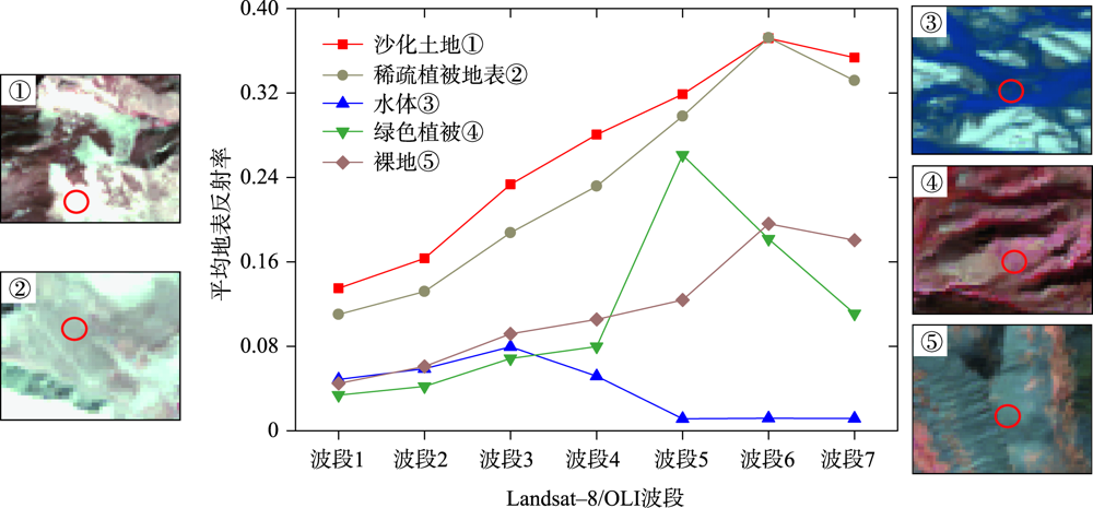
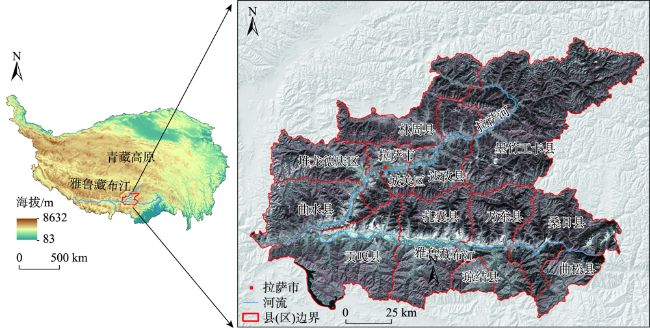
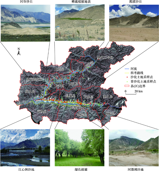
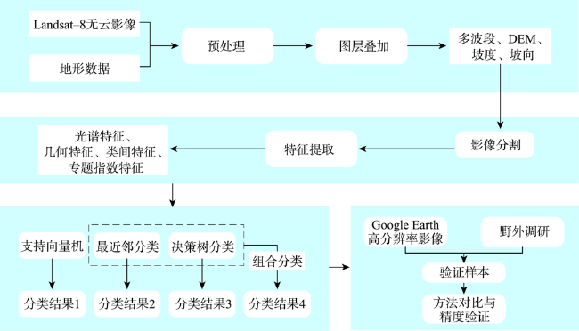
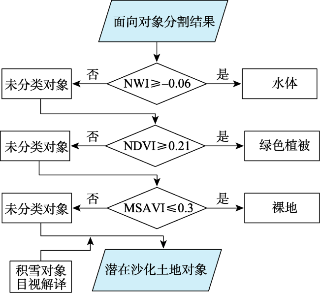
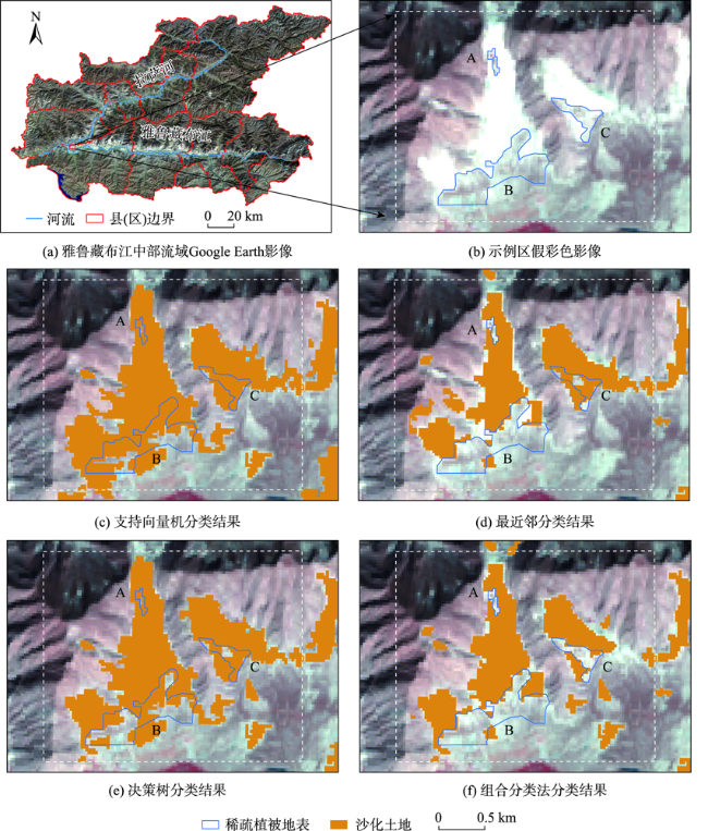
雅鲁藏布江中部流域长期遭受土地沙化侵蚀,采取有效手段进行沙化土地信息快速识别,跟踪土地沙化现状和动态发展,是土地沙化防治的基本前提。遥感数据因其快速、大范围、高精度监测等特点已被广泛应用于土地沙化监测。为降低该区域沙化土地破碎化分布特征以及广泛分布的稀疏植被地表对沙化土地遥感识别带来的不确定性,本文利用Google Earth Engine平台获取2019年秋季雅鲁藏布江中部流域Landsat无云遥感影像,基于面向对象的分类思想,充分提取沙化土地的光谱、几何和地形特征,根据不同的分类器构建4种分类方案,包括单一分类器(支持向量机、决策树、最近邻)分类以及组合分类法分类,提取雅江中游河谷地区沙化土地信息并验证不同方案的提取精度。结果表明:① 利用面向对象组合分类模型提取的沙化土地信息效果最佳,总体精度高达91.38 %,Kappa系数为0.82;② 相较于采用单一分类器(支持向量机、最近邻和决策树分类)的面向对象分类方法,组合分类模型能更有效地识别破碎化的小面积沙化土地,降低沙化土地与稀疏植被地表的混淆情况,提高分类可靠性;③ 基于面向对象组合分类模型反演得到雅鲁藏布江中部流域2019年沙化土地分布信息,土地沙化面积达299.61 km2,总体上呈现沿河谷的带状不连续分布,且集中分布于河流北岸以及靠近河道的阳坡、低海拔地区。本研究可为土地沙化遥感监测提供新思路,其应用可服务于雅鲁藏布江中部流域土地沙化预防和治理工作。
詹琪琪 , 赵伟 , 杨梦娇 , 付浩 , 李昕娟 , 熊东红 . 雅鲁藏布江中部流域土地沙化遥感识别[J]. 地球信息科学学报, 2022 , 24(2) : 391 -404 . DOI: 10.12082/dqxxkx.2022.210138
As the political, cultural, and economic core zone of Tibet, the middle part of the Yarlung Zangbo River basin has suffered from serious land desertification for a long time, posing obvious negative impacts for the local socio-economic development and natural environmental protection. It is the basic precondition for land desertification prevention and control to obtain spatial distribution, track the status quo, and analyze dynamic development of sandy land desertification. Remote sensing images have been widely used in the dynamical monitoring of sandy land information due to its characteristics of fast, large-scale, and high precision. In order to reduce the uncertainty caused by the fragmented distribution of sandy land and the large area of sparsely vegetation surfaces in this region, this study developed an object-oriented integrated classification method, combining decision tree classifier and nearest neighbor classifier. The method is based on the Landsat cloud-free images from Google Earth Engine platform. The spectral, geometrical, and topographic features of sandy land were extracted as the inputs of the method to differentiate sandy land from other land cover types, including the sparsely vegetated surfaces with similar spectral pattern as sandy land. The results indicated that, firstly, with the validation sample data collected from the Google Earth high-resolution images and field investigation, the integrated classification method has the highest overall accuracy of 92.38 % and the Kappa coefficient of 0.82. Secondly, compared with other single classifier classification methods, such as supported vector machine, nearest neighbor, and decision tree, the integrated classification method achieved the best classification results in identifying sandy land with small area. In addition, it also reduced the confusion between sandy land and sparsely vegetated surfaces, thus increased the reliability of the classification results. Thirdly, the sandy land in the middle part of the Yarlung Zangbo River basin in 2019 was mapped based on the proposed method with an area of 299.66 km2, displaying a zonal and fragmented pattern along river valleys and concentrating on the northern bank of rivers and the regions with southern aspect, low altitude, and close to riverways. This study provides a new direction for sandy land desertification monitoring with remote sensing data, and its application can also serve the prevention and management of sandy land desertification in the middle part of the Yarlung Zangbo River basin.
表1 特征数据集信息Tab. 1 Information of the selected features |
| 特征变量类别 | 变量名称 | 特征说明 |
|---|---|---|
| 光谱特征 | 波段均值(Band Mean) | Landsat-8/OLI波段1—7地表反射率 |
| 相邻对象的差异(Mean Difference to Neighbors) | Landsat-8/OLI波段1—7地表反射率差异 | |
| 几何特征 | 面积(Area) | 组成影像对象的像元数目 |
| 长宽比(Length/Width) | 包围影像对象的最小矩形的长宽比 | |
| 形状指数(Shape index) | 影像对象的周长与4倍面积平方根的比值 | |
| 地形特征 | 海拔(Elevation) | 组成影像对象的像元平均海拔 |
| 坡度(Slope) | 组成影像对象的像元平均坡度 | |
| 坡向(Aspect) | 组成影像对象的像元平均坡向 | |
| 专题指数 | 归一化植被指数(Normalized Difference Vegetation Index, NDVI) | |
| 新型水体指数(New Water Index, NWI) | ||
| 改进的土壤调节植被指数(Modified Soil Adjusted Vegetation Index, MSAVI) |
注:PNIR、PRED、PGREEN、PSWIR分别代表Landsat-8/OLI近红外波段、红光波段、绿光波段以及短波红外波段的地表反射率。 |
表2 4种分类方法的分类结果精度评价Tab. 2 Accuracy assessment of four classification results |
| 支持向量机 | 最近邻分类 | 决策树分类 | 组合分类法 | ||||||||||||
|---|---|---|---|---|---|---|---|---|---|---|---|---|---|---|---|
| 沙化 土地 | 非沙化 土地 | 总计 | 沙化 土地 | 非沙化 土地 | 总计 | 沙化 土地 | 非沙化 土地 | 总计 | 沙化 土地 | 非沙化 土地 | 总计 | ||||
| 沙化土地 | 107 | 26 | 133 | 102 | 31 | 133 | 108 | 25 | 133 | 116 | 17 | 133 | |||
| 非沙化土地 | 28 | 164 | 192 | 14 | 178 | 192 | 20 | 172 | 192 | 11 | 181 | 192 | |||
| 总计 | 135 | 190 | 116 | 209 | 128 | 197 | 127 | 198 | |||||||
| 生产者精度/% | 80.45 | 85.42 | 76.69 | 92.71 | 81.20 | 89.58 | 87.22 | 94.27 | |||||||
| 用户精度/% | 79.26 | 86.32 | 87.93 | 85.17 | 84.38 | 87.31 | 91.34 | 91.41 | |||||||
| 总体精度/% | 83.38 | 86.15 | 86.15 | 91.38 | |||||||||||
| Kappa系数 | 0.66 | 0.71 | 0.71 | 0.82 | |||||||||||
| [1] |
|
| [2] |
屠志方, 李梦先, 孙涛. 第五次全国荒漠化和沙化监测结果及分析[J]. 林业资源管理, 2016(1):1-5,13.
[
|
| [3] |
|
| [4] |
|
| [5] |
|
| [6] |
|
| [7] |
|
| [8] |
王志波, 高志海, 王琫瑜, 等. 基于面向对象方法的沙化土地遥感信息提取技术研究[J]. 遥感技术与应用, 2012, 27(5):770-777.
[
|
| [9] |
李长龙, 高志海, 吴俊君, 等. 基于分形网络进化分割和对象特征提取的GF-1卫星数据沙化土地分类识别研究[J]. 干旱区资源与环境, 2015, 29(11):152-157.
[
|
| [10] |
|
| [11] |
|
| [12] |
张亮亮, 张朝, 曹娟, 等. GEE环境下的玉米低温冷害损失快速评估[J]. 遥感学报, 2020, 24(10):1206-1220.
[
|
| [13] |
胡云锋, 商令杰, 张千力, 等. 基于GEE平台的1990年以来北京市土地变化格局及驱动机制分析[J]. 遥感技术与应用, 2018, 33(4):573-583.
[
|
| [14] |
张华, 安慧敏. 基于GEE的1987—2019年民勤绿洲NDVI变化特征及趋势分析[J]. 中国沙漠, 2021, 41(1):28-36.
[
|
| [15] |
|
| [16] |
|
| [17] |
崔海山, 张柏, 刘湘南. 松原市沙区土地利用变化及其对土地沙化的影响研究[J]. 水土保持学报, 2002, 16(4):66-69.
[
|
| [18] |
李志鹏, 曹晓明, 丁杰, 等. MODIS卫星影像显示的2001—2017年中国荒漠化年度状况[J]. 中国沙漠, 2019, 39(6):135-140.
[
|
| [19] |
|
| [20] |
|
| [21] |
宋伟东, 张亚男, 高琳, 等. 面向对象与决策树模型的辽西北地区沙化信息提取[J]. 辽宁工程技术大学学报(自然科学版), 2018, 37(3):595-601.
[
|
| [22] |
滑永春, 李增元, 高志海. 面向对象分割与混合像元分解相结合提取沙化土地信息[J]. 干旱区研究, 2020, 37(5):1346-1352.
[
|
| [23] |
胡钟山, 娄震, 杨静宇, 等. 基于多分类器组合的手写体数字识别[J]. 计算机学报, 1999, 22(4):369-374.
[
|
| [24] |
|
| [25] |
|
| [26] |
|
| [27] |
李长龙, 高志海, 吴俊君, 等. 基于分形网络进化分割和对象特征提取的GF-1卫星数据沙化土地分类识别研究[J]. 干旱区资源与环境, 2015, 29(11):152-157.
[
|
| [28] |
|
| [29] |
袁磊, 沈渭寿, 李海东, 等. 雅鲁藏布江中游河谷区域风沙化土地演变趋势及驱动因素[J]. 生态与农村环境学报, 2010, 26(4):301-305.
[
|
| [30] |
李永霞, 方江平. 西藏雅鲁藏布江中游地区土地沙化面积变化分析[J]. 贵州农业科学, 2011, 39(12):71-74,79.
[
|
| [31] |
沈渭寿, 李海东, 林乃峰, 等. 雅鲁藏布江高寒河谷流动沙地适生植物种筛选和恢复效果[J]. 生态学报, 2012, 32(17):5609-5618.
[
|
| [32] |
郑景云, 尹云鹤, 李炳元. 中国气候区划新方案[J]. 地理学报, 2010, 65(1):3-12.
[
|
| [33] |
席承藩, 张俊民. 中国土壤区划的依据与分区[J]. 土壤学报, 1982, 19(2):97-109,212.
[
|
| [34] |
|
| [35] |
|
| [36] |
|
| [37] |
|
| [38] |
|
| [39] |
朱良, 平博, 苏奋振, 等. 多时相TM影像决策树模型的水稻识别提取[J]. 地球信息科学学报, 2013, 15(3):446-451.
[
|
| [40] |
崔璐, 杜华强, 周国模, 等. 决策树结合混合像元分解的中国竹林遥感信息提取[J]. 遥感学报, 2019, 23(1):166-176.
[
|
| [41] |
|
| [42] |
|
| [43] |
|
| [44] |
|
| [45] |
|
| [46] |
|
| [47] |
|
| [48] |
|
| [49] |
|
| [50] |
|
| [51] |
陈秋晓, 骆剑承, 周成虎, 等. 基于多特征的遥感影像分类方法[J]. 遥感学报, 2004, 8(3):239-245.
[
|
| [52] |
王文静, 张霞, 赵银娣, 等. 综合多特征的Landsat 8时序遥感图像棉花分类方法[J]. 遥感学报, 2017, 21(1):115-124.
[
|
| [53] |
|
| [54] |
丁凤. 一种基于遥感数据快速提取水体信息的新方法[J]. 遥感技术与应用, 2009, 24(2):167-171.
[
|
| [55] |
|
| [56] |
|
| [57] |
|
| [58] |
刘慧, 李晓英, 夏翠珍, 等. 雅鲁藏布江河谷加查-米林段沙丘成因[J]. 中国沙漠, 2020, 40(3):16-26.
[
|
| [59] |
孙明, 沈渭寿, 李海东, 等. 雅鲁藏布江源区风沙化土地演变趋势[J]. 自然资源学报, 2010, 25(7):1163-1171.
[
|
/
| 〈 |
|
〉 |

