
基于SAR影像后向散射特性的中俄黑龙江流域洪水监测
|
张文璇(1997— ),女,河北承德人,硕士生,主要从事遥感科学与技术研究。E-mail: zhangwx@lreis.ac.cn |
收稿日期: 2021-01-13
修回日期: 2021-03-02
网络出版日期: 2022-06-25
基金资助
中国科学院战略性先导科技专项(XDA19040501)
中国科学院特别交流计划(Y9X90050Y2)
中国工程科技知识中心建设项目(CKCEST-2019-3-6)
版权
Flood Monitoring of Heilongjiang River Basin in China and Russia Transboundary Region based on SAR Backscattering Characteristics
Received date: 2021-01-13
Revised date: 2021-03-02
Online published: 2022-06-25
Supported by
the Strategic Priority Research Program of the Chinese Academy of Sciences(XDA19040501)
Special Exchange Program of Chinese Academy of Sciences grant number(Y9X90050Y2)
Construction Project of China Knowledge Center for Engineering Sciences and Technology(CKCEST-2019-3-6)
Copyright
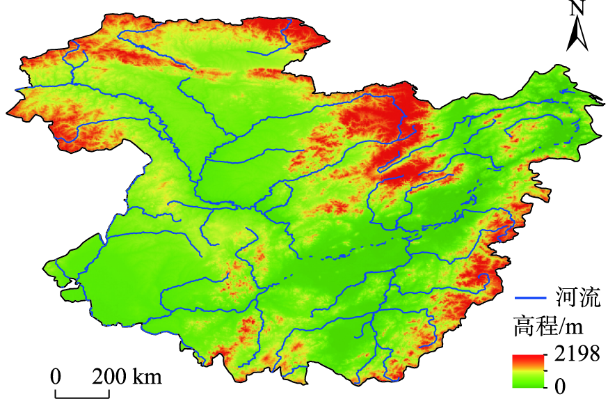
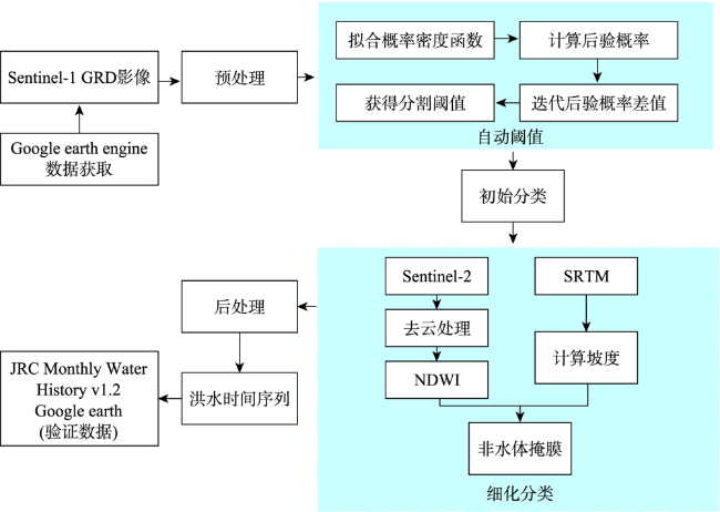
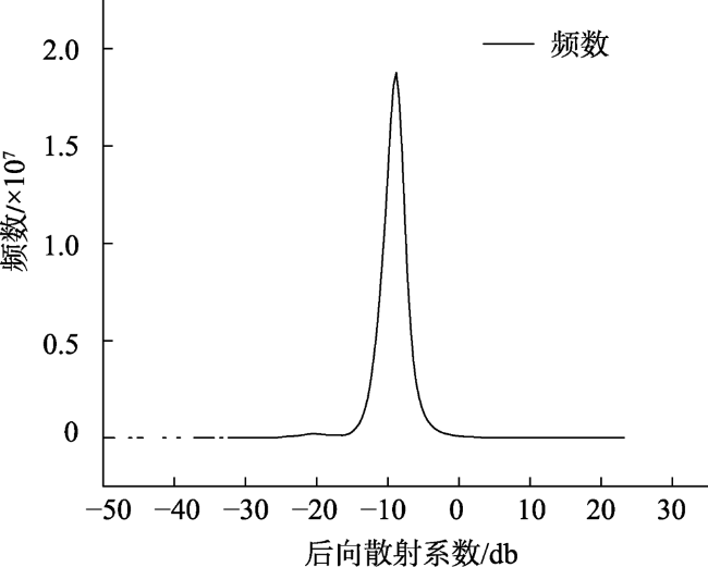
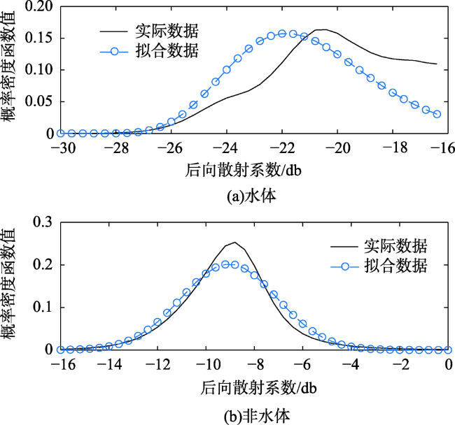
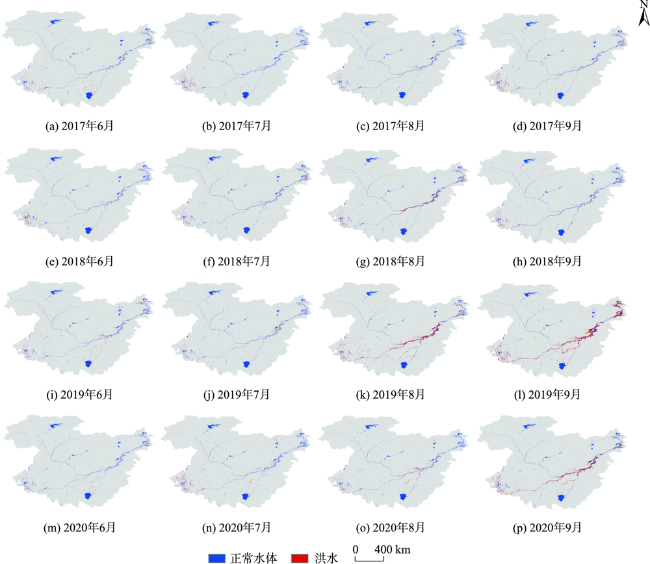
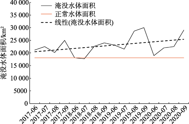
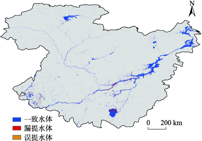
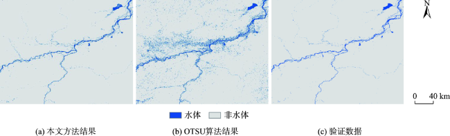
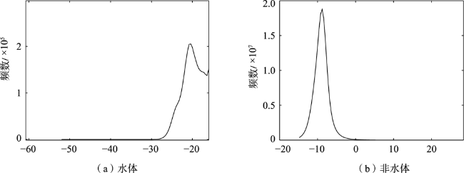
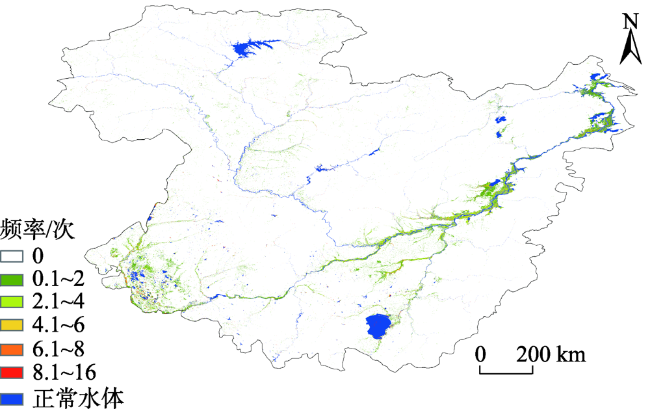
黑龙江(又称为阿穆尔河)是中国和俄罗斯之间的国际界河,近年来洪水事件频发,给流域内中俄两国带来巨大的人口伤亡和经济损失,加强该流域的洪水监测是两国面临的共同紧迫需求。传统的光学遥感影像受制于洪水期间多云多雨的天气状况,难以及时获得无云影像。本文充分利用全天候雷达数据的优势,提出了一种基于哨兵1号(Sentinel-1)合成孔径雷达数据监测大面积区域洪水的方法。通过Gamma分布和高斯分布拟合SAR影像后向散射系数的概率密度分布,迭代后验概率差值,自动获得全局阈值来分割初始的水体,基于辅助数据细化去除了初始水体中与水体相似的误分类型,并由形态学操作后处理提高了提取的洪水的均匀性。结果表明:① 与传统的分割算法相比,本文提出的方法基于SAR影像后向散射系数的分布规律进行概率密度函数分段拟合,将全局统计划分为局部关系,显著地改善了常规分割算法在水体和非水体像素量级相差过大而表现不佳的情况;② 研究获得了2017—2020年逐年的洪水分布,结果总体精度在87.78%~94.89%之间,Kappa系数在0.76~0.89之间;③ 特别是对于大面积半干旱地区,本文结合了后向散射特性、地形和其他辅助信息的关系,使得能够有效地保留水体并去除与水体后向散射系数相似的地物;④ 结果显示黑龙江(阿穆尔河)中下游沿岸城市哈巴罗夫斯克、阿穆尔斯克等地区为经常性泛洪区域,洪水面积整体呈增加趋势。研究表明,基于雷达数据对洪水空间范围进行时间序列监测,可以为中俄黑龙江流域洪水发展动态监测提供科学支撑。
张文璇 , 王卷乐 . 基于SAR影像后向散射特性的中俄黑龙江流域洪水监测[J]. 地球信息科学学报, 2022 , 24(4) : 802 -813 . DOI: 10.12082/dqxxkx.2022.210018
In recent years, Heilongjiang (Amur) River, a border river between China and Russia, is frequently flooded, which brings huge population casualties and economic losses to China and Russia in the basin. Strengthening flood monitoring in the basin is an urgent need for both countries. Influenced by terrible cloudy and rainy weather during the flooding season, the function of traditional optical remote sensing images are restricted. Thus, it is difficult to obtain cloud-free images during the flood. In this paper, through making full use of the advantages of all-weather radar data, a method of monitoring flood in large area based on Sentinel-1 synthetic aperture radar data is proposed. The probability density distribution of backscattering coefficient of SAR image is fitted by Gamma distribution and Gaussian distribution. The global threshold is obtained automatically to segment the initial water by iterating a posteriori probability difference. The misclassification type that looks like water in the initial water classification is refined and removed based on auxiliary data. Moreover, the uniformity of the extracted flood is improved by the post-processing of morphological operation. It can be concluded from the results that, firstly, compared with the traditional segmentation algorithm, the method proposed in this paper carries out the piecewise fitting of the probability density function based on the distribution law of the backscattering coefficient of the SAR image. It also divides the global statistics into local relations, which significantly improves the poor performance, caused by the large difference between water and non-water pixels, of the conventional segmentation algorithm. The flood distribution year by year from 2017 to 2020 is obtained. The overall accuracy of the results is between 87.78% and 94.89% while the Kappa coefficient is between 0.76 and 0.89. Secondly, especially for large semi-arid areas, this paper uses the relationships among backscattering characteristics, topography, and other auxiliary information, to ensure that water can be effectively preserved while the non-water objects similar to the backscattering coefficient of water can be removed. Thirdly, the results reflect that areas along the middle and lower reaches of Heilongjiang (Amur) River, such as Khabarovsk and Amursk, have frequent floods. Meanwhile, the flood area shows an increasing trend as a whole. The research shows that the time series monitoring of flood spatial extent based on radar data can provide scientific support for flood development dynamic monitoring in Heilongjiang River basin in China and Russia.
表1 中俄黑龙江流域洪水提取精度验证Tab. 1 Accuracy verification of flooding region extraction in Heilongjiang River basin of China and Russia |
| 年份 | 总体精度/% | 生产者精度/% | 用户精度/% | Kappa |
|---|---|---|---|---|
| 2017 | 94.89 | 89.58 | 90.90 | 0.89 |
| 2018 | 93.90 | 87.50 | 89.36 | 0.87 |
| 2019 | 87.78 | 77.55 | 78.85 | 0.76 |
| 2020 | 93.80 | 87.56 | 89.40 | 0.87 |
| [1] |
|
| [2] |
|
| [3] |
|
| [4] |
Emergency Events Database[DB]. https://public.emdat.be/.
|
| [5] |
曾玲方, 李霖, 万丽华. 基于Sentinel-1卫星SAR数据的洪水淹没范围快速提取[J]. 地理信息世界, 2015,22(5):100-103,107.
[
|
| [6] |
李加林, 曹罗丹, 浦瑞良. 洪涝灾害遥感监测评估研究综述[J]. 水利学报, 2014,45(3):253-260.
[
|
| [7] |
|
| [8] |
孙亚勇, 黄诗峰, 李纪人, 等. Sentinel-1A SAR数据在缅甸伊洛瓦底江下游区洪水监测中的应用[J]. 遥感技术与应用, 2017,32(2):282-288.
[
|
| [9] |
|
| [10] |
|
| [11] |
|
| [12] |
|
| [13] |
|
| [14] |
|
| [15] |
戴长雷, 李治军, 林岚. 黑龙江(阿穆尔河)流域水势研究[M]. 哈尔滨: 黑龙江教育出版社, 2014.
[
|
| [16] |
杨魁, 杨建兵, 江冰茹. Sentinel-1卫星综述[J]. 城市勘测, 2015(2):24-27.
[
|
| [17] |
杨金明, 刘志辉. Sentinel-1卫星数据产品应用探讨[J]. 地理信息空间, 2016,12(12):1672-4623.
[
|
| [18] |
徐颖, 周焰. SAR图像相干斑抑制研究进展[J]. 计算机工程与应用, 2013,49(20):210-216.
[
|
| [19] |
|
| [20] |
|
| [21] |
陈玲艳, 刘智, 张红. 基于水体散射特性的SAR图像水体检测[J]. 遥感技术与应用, 2014,29(6):963-969.
[
|
| [22] |
|
| [23] |
|
| [24] |
|
/
| 〈 |
|
〉 |
