
基于自然格网索引的多尺度面实体增量级联更新方法
|
焦洋洋(1989— ),男,河南修武人,博士生,从事自动制图综合与空间数据更新研究。E-mail: johnpanther@163.com |
收稿日期: 2021-07-14
要求修回日期: 2021-09-04
网络出版日期: 2022-07-25
基金资助
国家自然科学基金项目(42071450)
国家自然科学基金项目(41801396)
版权
Multi-scale Surface Entity Cascade Update Method based on Natural Grid Network Index
Received date: 2021-07-14
Request revised date: 2021-09-04
Online published: 2022-07-25
Supported by
National Natural Science Foundation of China(42071450)
National Natural Science Foundation of China(41801396)
Copyright
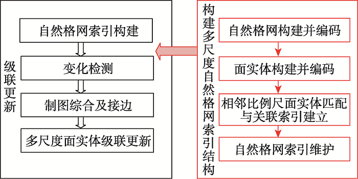
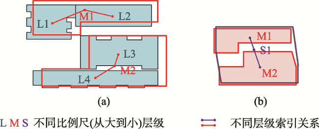
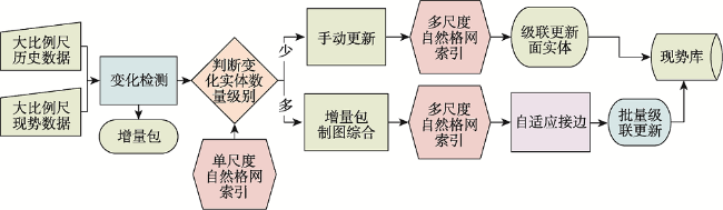
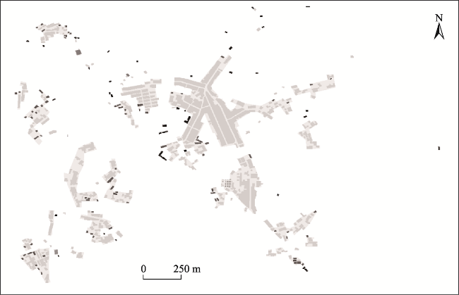
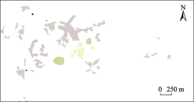
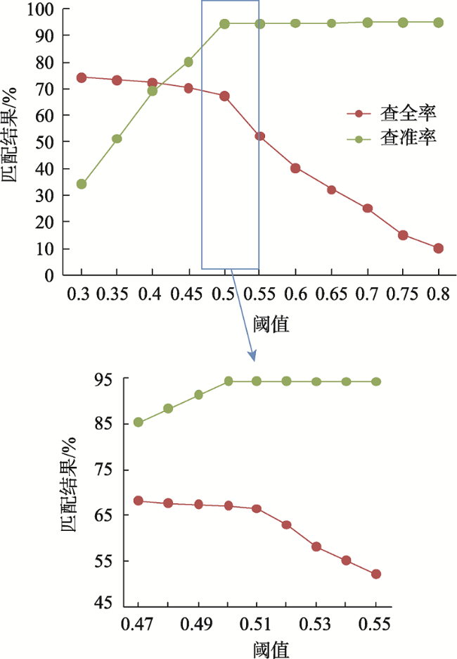
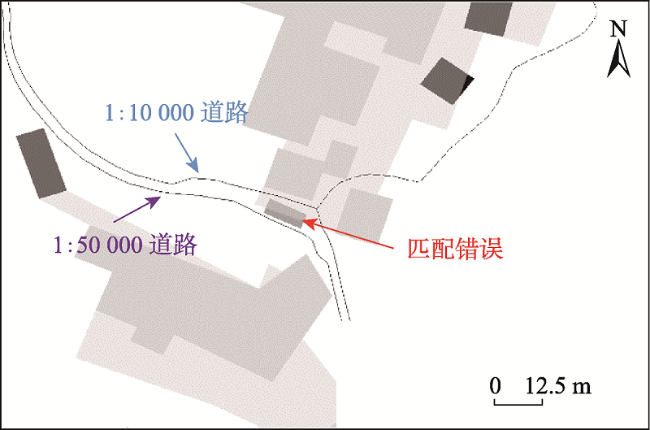
多尺度地理空间数据增量级联更新方法是增强地理空间数据的现势性的重要手段之一。级联更新包括多尺度数据匹配、关联关系建立、匹配与变化检测、增量信息制图综合、级联更新等步骤,其中,相邻比例尺数据匹配是多尺度数据关联关系建立的基本方法,也是实现级联更新的重要基础。针对现有方法中多尺度同名实体间的关联关系匹配的精度和效率问题,本文提出了基于自然格网索引的多尺度面实体增量级联更新方法。首先,检测出同源同尺度矢量空间数据发生变化的增量包;其次通过自然格网索引确定更新实体所在格网位置,并进行删除、自动或手动更新;最后实施制图综合、接边以及多尺度面实体增量级联更新信息传递操作。以赣州市虎山乡部分区域居民地要素为例,实验结果表明:① 在匹配阈值为0.51的情况下,相较于直接匹配的方法,采用本文提出的自然格网索引方法进行匹配所消耗的时间减少了88.4%,查全率和查准率分别提升了5%和4%,充分说明了自然格网索引方法在匹配相邻尺度间地理要素时的必要性; ② 相较于传统的Hausdorff距离、欧式距离和质心包含3种匹配方法,本文所提出的方法在耗时(1.34 s)、查全率(66.5%)和查准率(94.1%)方面处于领先地位,这充分说明了本文提出的级联更新方法的优越性; ③ 本文提出的方法可免除关联居民地差异的影响,从而大大减少人工编辑的作业时间,并可有效提高多尺度居民地实体增量级联更新的精度和效率。
焦洋洋 , 刘平芝 , 熊顺 , 徐道柱 . 基于自然格网索引的多尺度面实体增量级联更新方法[J]. 地球信息科学学报, 2022 , 24(5) : 851 -863 . DOI: 10.12082/dqxxkx.2022.210350
The incremental cascade updating of multi-scale geospatial data is one of the important means to enhance the real time of geospatial data. The incremental cascade updating includes multi-scale data matching, correlation relationship establishment, matching and change detection, incremental information generalization, and incremental cascade update. The adjacent scale data matching is the basic of multi-scale data correlation establishment and an important foundation for the implementation of incremental cascade update. Aiming at the low accuracy and efficiency of association matching between multi-scale entities with the same name in existing methods, an incremental cascade updating method of multi-scale surface entities based on natural grid index is proposed. By building the natural grid and coding, building the surface entity and assigning code, adjacent scale entity matching and associated relationship, the corresponding steps of the correlation relationship are established, and the natural grid index is introduced into the incremental cascade update. The specific steps include: firstly, incremental packets of the same source and same scale vector spatial data are detected; secondly, the grid location of the updating entity is determined by the natural grid index, and then deleted and updated automatically or manually; and finally, the cartographic generalization and edge joining are implemented. Taking the residential elements in Hushan villiage of Ganzhou City as an example, the experimental results show that: 1) when the matching threshold is set to 0.51, compared to the direct matching method, the time consumed by the natural grid index method proposed in this paper is reduced by 88.4%, and the recall and precision are increased by 5% and 4%, respectively, which demonstrates the effectiveness of the natural grid index method in matching geographical elements between adjacent scales; 2) compared with the traditional Hausdorff distance, Euclidean distance, and centroid methods, the method proposed in this paper performs best with low time cost (1.34s), and high recall (66.5%) and precision rates (94.1%), which demonstrates the effectiveness and efficiency of the cascade update method proposed in this paper; 3) the proposed method can avoid the influence of the difference of associated residential areas, thus greatly reducing the operation time of manual editing, and effectively improving the accuracy and efficiency of multi-scale incremental cascade updating of residential entities.
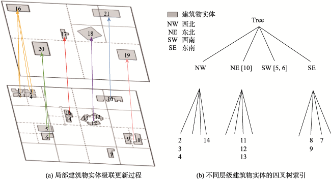
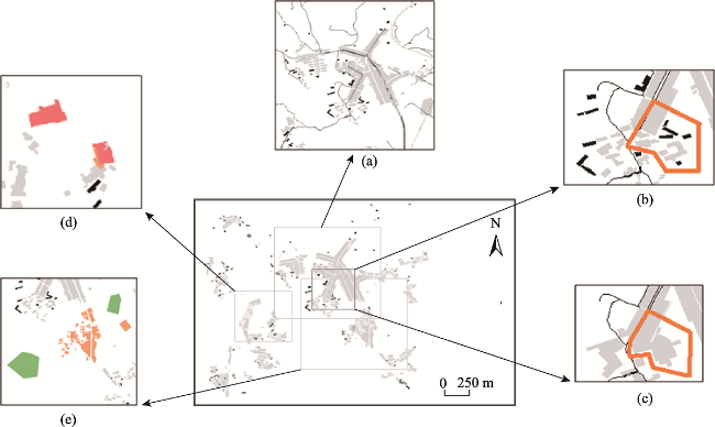
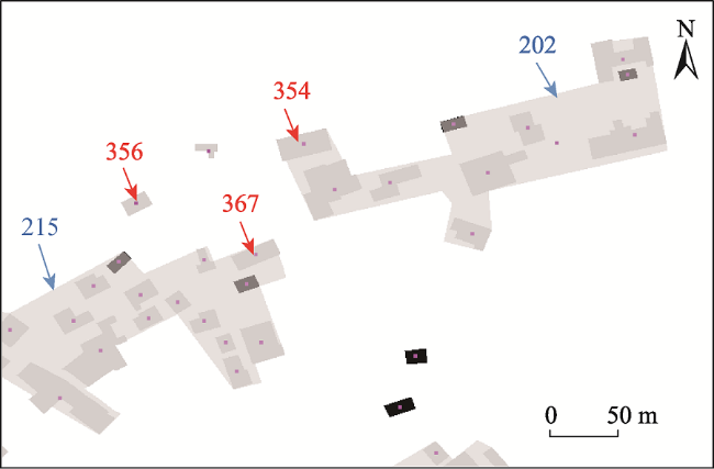
图7 居民地实体动态级联更新过程示例Fig. 7 Example of dynamic cascade updating process of residential entity |
表1 1:10 000居民地实体编码Tab. 1 Code of 1:10 000 vector residential entity |
| 序号 | 实体编码 |
|---|---|
| 1 | G001132013000232-130204-1550 |
| 2 | G001132013000232-130102-1551 |
| 3 | G001132013000232-130206-1572 |
| 4 | G001132013000232-130102-1598 |
| 5 | G001132013000232-130204-1652 |
| 6 | G001132013000232-130204-1653 |
| 7 | G001132013000232-130102-1704 |
| 8 | G001132013000232-130102-1705 |
| 9 | G001132013000232-130102-1707 |
| 10 | G001132013000232-130204-1874 |
表2 是否采用自然格网索引的匹配结果比较Tab. 2 Comparison of matching results whether to use natural grid index |
| 匹配方法 | 耗时/s | 匹配数/个 | 正确数/个 | 查全率/% | 查准率/% |
|---|---|---|---|---|---|
| 直接匹配 | 11.55 | 346 | 312 | 61.5 | 90.1 |
| 基于自然格网索引匹配 | 1.34 (构建格网索引耗时0.53) | 358 | 337 | 66.5 | 94.1 |
表3 3种传统匹配方法结果对比Tab. 3 Result statistics of three traditional matching methods |
| 匹配方法 | 耗时/s | 匹配数/个 | 正确数/个 | 查全率/% | 查准率/% |
|---|---|---|---|---|---|
| Hausdorff距离 | 7.59 | 305 | 277 | 52.7 | 87.5 |
| 欧式距离 | 8.18 | 318 | 242 | 47.7 | 76.1 |
| 质心包含 | 4.12 | 325 | 293 | 57.8 | 90.2 |
| [1] |
|
| [2] |
陈军, 王东华, 商瑶玲, 等. 国家1:50 000数据库更新工程总体设计研究与技术创新[J]. 测绘学报, 2010, 39(1):7-10.
[
|
| [3] |
蒋捷, 陈军. 基础地理信息数据库更新的若干思考[J]. 测绘通报, 2000(5):1-3.
[
|
| [4] |
许俊奎. 多尺度居民地要素增量级联更新方法研究[D]. 郑州:信息工程大学, 2013.
[
|
| [5] |
刘建军, 李雪梅, 张元杰, 等. 国家1:25万基础地理信息数据库联动更新技术设计与工程应用[J]. 测绘通报, 2016(4):1-4.
[
|
| [6] |
张鹏, 韦通, 李庆永, 等. 省市级基础地理信息框架数据联动更新探究[J]. 山东国土资源, 2016, 32(11):65-69.
[
|
| [7] |
张新长, 张志强, 孙颖, 等. 模式识别的空间数据联动更新技术研究[J]. 测绘科学, 2019, 44(1):66-72.
[
|
| [8] |
魏雪梅. 多级时空数据库联动增量更新方法[J]. 测绘通报, 2019(5):134-138.
[
|
| [9] |
|
| [10] |
罗鹏, 张俊, 王明亮, 等. 基础地理信息联动更新技术研究与应用[J]. 测绘与空间地理信息, 2017, 40(6):83-85.
[
|
| [11] |
付荣祥, 吴彬卓, 叶哲璐. 地理空间数据库联动更新技术[J]. 测绘通报, 2017(5):136-138.
[
|
| [12] |
方川, 白光平. 多尺度地图数据库更新机制研究及应用[J]. 测绘与空间地理信息, 2021, 44(2):86-89.
[
|
| [13] |
汪艳霞, 杜清运, 任福, 等. 目标相似性的矢量数据联动更新方法[J]. 测绘科学, 2015, 40(5):106-111.
[
|
| [14] |
王建丽. 面向电子地图服务的地理框架数据联动更新技术研究与实现[D]. 郑州:信息工程大学, 2015.
[
|
| [15] |
|
| [16] |
赵慧慧, 赵凡, 陈仁海, 等. 基于地理空间大数据的高效索引与检索算法[J]. 计算机研究与发展, 2020, 57(2):333-345.
[
|
| [17] |
秦育罗, 郭冰, 孙小荣. 改进Hausdorff距离及其在多尺度道路网匹配中的应用[J]. 测绘科学技术学报, 2020, 37(3):313-318.
[
|
| [18] |
王峰, 安晓亚, 朱璇. 地理空间数据增量更新版本化管理方法研究[J]. 地理空间信息, 2021, 19(2):26-29.
[
|
| [19] |
郭沛沛, 李成名, 殷勇. 建筑物合并的Delaunay三角网分类过滤法[J]. 测绘学报, 2016, 45(8):1001-1007.
[
|
| [20] |
张新长, 郭泰圣, 唐铁. 一种自适应的矢量数据增量更新方法研究[J]. 测绘学报, 2012, 41(4):613-619.
[
|
| [21] |
|
| [22] |
|
| [23] |
程昌秀. 矢量数据多尺度空间索引方法的研究[J]. 武汉大学学报信息科学版, 2009, 34(5):597-601.
[
|
| [24] |
许俊奎, 武芳, 钱海忠. 多比例尺地图中居民地要素之间的关联关系及其在空间数据更新中的应用[J]. 测绘学报, 2013, 42(6):898-905,912.
[
|
| [25] |
赵彬彬, 邓敏, 李光强, 等. 基于城市形态学原理的面状地物层次索引方法[J]. 测绘学报, 2010, 39(4):435-440.
[
|
| [26] |
杨敏, 艾廷华, 周启. 顾及道路目标stroke特征保持的路网自动综合方法[J]. 测绘学报, 2013, 42(4):581-587,594.
[
|
| [27] |
许俊奎, 武芳, 钱海忠, 等. 一种空间关系相似性约束的居民地匹配算法[J]. 武汉大学学报·信息科学版, 2013, 38(4):484-488.
[
|
| [28] |
石善球. 矢量空间数据变化检测及其应用研究[J]. 测绘与空间地理信息, 2020, 43(9):25-29.
[
|
/
| 〈 |
|
〉 |