
基于改进SVM分类法的SAR图像水体面积提取研究
|
邱凤婷(1994— ),女,江苏宿迁人,硕士生,主要研究方向为资源环境遥感。E-mail: qiuft@aircas.ac.cn |
收稿日期: 2021-02-24
要求修回日期: 2021-04-01
网络出版日期: 2022-07-25
基金资助
中国科学院中国—斯里兰卡水技术研究与示范联合中心项目
版权
Water Body Area Extraction from SAR Image based on Improved SVM Classification Method
Received date: 2021-02-24
Request revised date: 2021-04-01
Online published: 2022-07-25
Supported by
Program of China-Sri Lanka Joint Center for Water Technology Research and Demonstration by the Chinese Academy of Sciences (CAS), China-Sri Lanka Joint Center for Education and Research by the CAS
Copyright
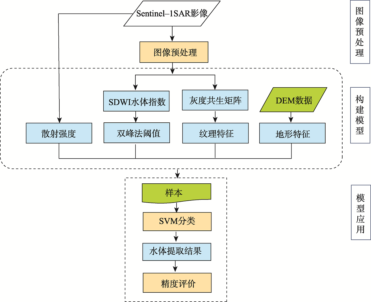
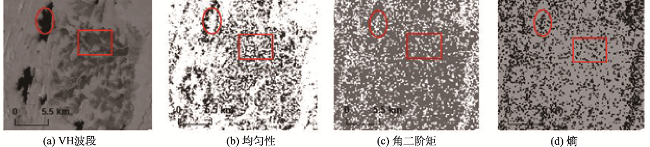
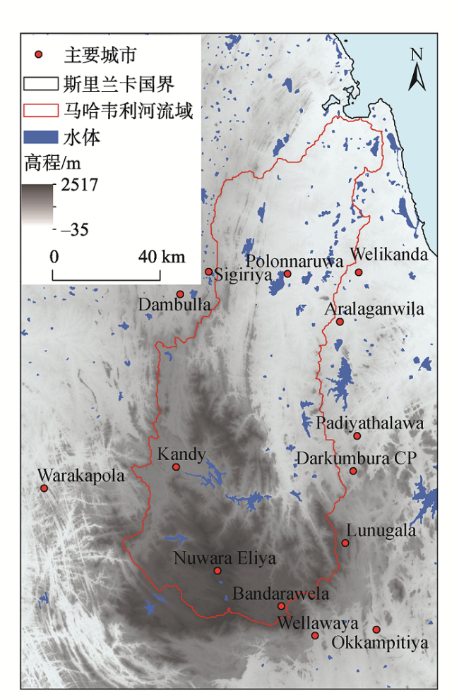
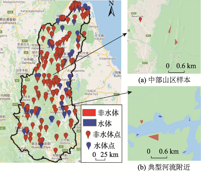
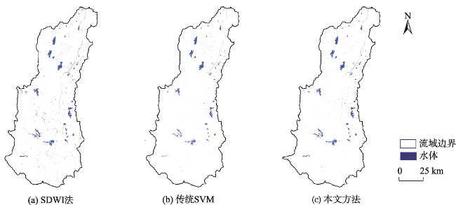
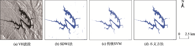
在复杂地表环境下的多云多雨地区,基于合成孔径雷达(SAR)图像提取水体时容易受到其它地物如水田、山体阴影等干扰,传统的灰度阈值法和SVM法未能考虑水体与其它地物在纹理和地形上的差异,因此水体提取结果精度较差。研究首先用Refined Lee滤波对SAR图像进行预处理;其后通过DEM建模和坡度计算提取地形特征,通过计算图像灰度共生矩阵以提取纹理特征(包括均匀性、角二阶矩和熵),并结合SAR图像极化信息以及SDWI指数形成针对水体提取的特征空间,通过融合地形特征和图像纹理特征发展了改进SVM 分类法的水体提取模型。在使用Sentinel-1 SAR数据对所发展模型与SDWI水体指数法、传统SVM法水体提取结果进行比对后发现,改进SVM分类法提取的水体结果较好地剔除了水田和山体阴影,且提取的水体水面比传统的SVM法更加完整;该方法在总体精度、Kappa系数、漏分率和错分率指标上均优于SDWI法和传统的SVM法,总体精度达到98.06%,比SDWI法和传统的SVM法分别提高了23.24%和5.49%,有效提高了复杂环境下地表水体的提取精度。研究最后将所发展模型应用于2018年马哈韦利河流域逐月水体提取与变化分析,有效解决了山体阴影和水田误分问题。本文提出的改进SVM法可以实现复杂地表环境下大范围水体信息准确、完整提取。
关键词: SVM; 复杂水环境; Sentinel-1 SAR数据; 水体提取; SDWI; 地形特征; 纹理特征; 斯里兰卡马哈韦利河流域
邱凤婷 , 过志峰 , 张宗科 , 魏显虎 , 景睦馨 . 基于改进SVM分类法的SAR图像水体面积提取研究[J]. 地球信息科学学报, 2022 , 24(5) : 940 -948 . DOI: 10.12082/dqxxkx.2022.210095
In cloudy and rainy regions with complex surface environments, water body extraction based on Synthesis Aperture Radar (SAR) image is easily interfered by other surface features such as paddy field and mountain shadow. The traditional gray threshold method and SVM method fail to take into account the differences in texture and terrain information between water and other surface features, resulting in the low accuracy of water body extraction. In this paper, we first use refined Lee filter to pre-process the SAR image, then extract terrain features by modeling DEM and calculating the slope information. We extract the texture features, including the homogeneity (hom), Angular Second Moment (ASM), and entropy (ENT), by calculating image Gray Level Co-occurrence Matrix (GLCM) based on the SAR image. Meanwhile, polarization band information of the SAR image and SDWI index are combined to form the SVM feature space for water body extraction. Finally, an improved SVM classification method for water body extraction is proposed by fusing terrain features with image texture features. Compared with SDWI water index method and traditional SVM method based on Sentinel-1 SAR data, it is found that the improved SVM method can remove the shadows of paddy field and mountain. The result of water surface extraction by the improved SVM method is more complete than that of traditional SVM method. The result also shows that the improved SVM method performs better than SDWI method and traditional SVM method in terms of overall accuracy, kappa coefficient, leakage rate, and error rate. The overall accuracy of the improved SVM method is 98.06%, which is 23.24% and 5.49% higher than that of SDWI method and traditional SVM method, respectively, demonstrating that the improved SVM method can effectively improve the extraction accuracy of surface water in complex environments. The developed method is applied to monthly water extraction and change analysis of Mahaweli River Basin in 2018, which proves that the method can effectively solve the problems of mountain shadow and paddy field misclassification. The improved SVM method can realize the accurate and complete large-scale water body information extraction in complex surface environments.
表1 2018年马哈韦利河流域Sentinel-1影像Tab. 1 Sentinel-1 image of Mahaweli River Basin in 2018 |
| 时间 | VH波段数 | VV波段数 |
|---|---|---|
| 2018年1月 | 6 | 6 |
| 2018年2月 | 4 | 4 |
| 2018年3月 | 4 | 4 |
| 2018年4月 | 6 | 6 |
| 2018年5月 | 9 | 9 |
| 2018年6月 | 4 | 4 |
| 2018年7月 | 4 | 4 |
| 2018年8月 | 4 | 4 |
| 2018年9月 | 6 | 6 |
| 2018年10月 | 4 | 4 |
| 2018年11月 | 6 | 6 |
| 2018年12月 | 4 | 4 |
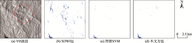
图6 不同方法在山区提取结果比较注:红圈中为局部山体阴影,蓝色为提取结果。 Fig. 6 Comparison of different extraction methods in mountainous area |
图7 不同方法在水田灌溉区提取结果比较注:红圈中为局部水田区域,蓝色为提取结果。 Fig. 7 Comparison of different extraction methods in paddy field |
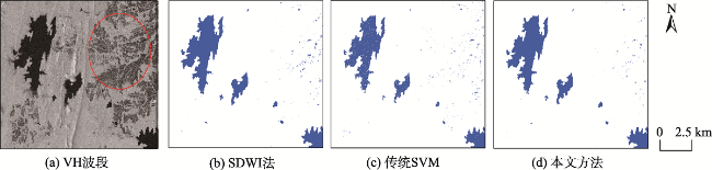
图8 不同方法对典型水库提取结果比较注:蓝色为提取结果。 Fig. 8 Comparison of different extraction methods for typical reservoirs |
表2 不同方法的分类精度Tab. 2 Classification accuracy of different methods |
| 方法 | 非水体 | 水体 | 总体精度/% | Kappa系数 | |||
|---|---|---|---|---|---|---|---|
| 漏分率/% | 错分率/% | 漏分率/% | 错分率/% | ||||
| SDWI法 | 37.23 | 0.19 | 0.24 | 43.58 | 74.82 | 0.52 | |
| 传统SVM法 | 6.27 | 4.83 | 9.84 | 12.58 | 92.57 | 0.83 | |
| 本文方法 | 2.76 | 0.12 | 0.24 | 5.43 | 98.06 | 0.96 | |
| [1] |
李丹, 吴保生, 陈博伟, 等. 基于卫星遥感的水体信息提取研究进展与展望[J]. 清华大学学报(自然科学版), 2020, 60(2):147-161.
[
|
| [2] |
周鹏, 谢元礼, 蒋广鑫, 等. 遥感影像水体信息提取研究进展[J]. 遥感信息, 2020, 35(5):9-18.
[
|
| [3] |
曾玲方, 李霖, 万丽华. 基于Sentinel-1卫星SAR数据的洪水淹没范围快速提取[J]. 地理信息世界, 2015, 22(5):100-103,107.
[
|
| [4] |
|
| [5] |
|
| [6] |
崔倩, 毛旭东, 陈德清, 等. 基于高分三号卫星数据的水体自动提取及应用[J]. 中国农业信息, 2019, 31(5):57-65.
[
|
| [7] |
李景刚, 黄诗峰, 李纪人. ENVISAT卫星先进合成孔径雷达数据水体提取研究——改进的最大类间方差阈值法[J]. 自然灾害学报, 2010, 19(3):139-145.
[
|
| [8] |
陈媛媛, 郑加柱, 魏浩翰, 等. 基于Sentinel-1A数据的南京市水体信息提取[J]. 地理空间信息, 2020, 18(9):62-65,7.
[
|
| [9] |
湛南渝, 李小涛, 路京选, 等. 基于SLIC的哨兵1号雷达数据水体信息提取[J]. 人民长江, 2020, 51(4):213-217,225.
[
|
| [10] |
贾诗超, 薛东剑, 李成绕, 等. 基于Sentinel-1数据的水体信息提取方法研究[J]. 人民长江, 2019, 50(2):213-217.
[
|
| [11] |
巩钰, 杨雨晴. 基于Sentinel-1 SAR影像的洪水淹没范围快速提取与变化分析[A]. 江苏省测绘地理信息学会.江苏省测绘地理信息学会2020年学术年会论文集[C]. 江苏省测绘地理信息学会:《现代测绘》编辑部, 2020: 4.
[
|
| [12] |
骆剑承, 周成虎, 梁怡, 等. 支撑向量机及其遥感影像空间特征提取和分类的应用研究[J]. 遥感学报, 2002, 6(1):50-55.
[
|
| [13] |
|
| [14] |
|
| [15] |
|
| [16] |
安智晖, 余洁, 刘利敏. 结合纹理信息的极化SAR影像分类研究[J]. 地理空间信息, 2016, 14(2):41-43,8.
[
|
| [17] |
|
| [18] |
程贇. 基于Sentinel-1的南极冰盖冻融探测方法研究[D]. 西安:西安科技大学, 2019.
[
|
| [19] |
|
/
| 〈 |
|
〉 |