
基于GEE和U-net模型的同震滑坡识别方法
|
刘 佳(1993—),男,河北沧州人,博士研究生,主要研究方向为滑坡识别与动力学模拟,E-mail: liuj.19b@igsnrr.ac.cn |
收稿日期: 2021-11-03
修回日期: 2022-01-17
网络出版日期: 2022-09-25
基金资助
中国科学院战略性先导科技专项(A类)子课题(XDA23090503)
国家重点研发计划项目(YS2018YFGH000001)
国家重点研发计划项目(2018YFC1505503)
Image Recognition of Co-seismic Landslide based on GEE and U-net Neural Network
Received date: 2021-11-03
Revised date: 2022-01-17
Online published: 2022-09-25
Supported by
The Strategic Priority Research Program of the Chinese Academy of Sciences(XDA23090503)
National Key Research and Development Plan of China(YS2018YFGH000001)
National Key Research and Development Plan of China(2018YFC1505503)
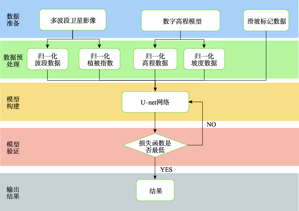
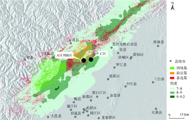
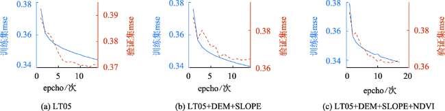
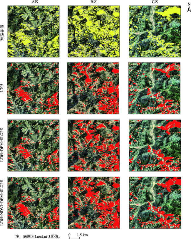
地震滑坡解译是震后重建的重要基础工作,主要通过室内人工遥感解译和室外野外调查确定。地震滑坡相比其他地物来说更为复杂,很难通过简单指数识别。室内遥感解译通过滑坡后壁、侧壁和堆积等纹理特征进行识别,大面积同震滑坡解译工作往往耗费大量人力和物力,且耗时长,难以满足灾害应急需求。本研究利用U-net神经网络模型,结合Google Earth Engine(GEE)云平台和人工智能学习平台Tensorflow,以地震局解译的汶川滑坡作为样本数据,以震后30 m分辨率的Landsat影像、高程、坡度以及NDVI数据作为模型输入参数,自动识别并获取了汶川地震后的同震滑坡数据,同时比较了不同参数组合情况下U-net神经网络模型的分割识别精度。研究表明:① U-net模型可以用于以Landsat影像为基础数据的同震滑坡快速自动识别;② 随着高程、坡度以及NDVI等输入参数增加,模型分割精度在逐渐提高,但假阳性结果也会出现增多,震后滑坡影像+高程+坡度+NDVI的输入参数组合精度最高;③ 在细节上,模型在多参数组合的情况下,大型滑坡能够很好被识别,一些较小型的滑坡受制于影像分辨率的影响,分割精度较差。为了更好识别小型滑坡,后续研究可能需提高影像的分辨率。此外,GEE云平台大大提高了训练样本获取的效率,为科研人员快速进行基于神经网络与遥感数据的地物识别研究提供了条件。
刘佳 , 伍宇明 , 高星 , 司文涛 . 基于GEE和U-net模型的同震滑坡识别方法[J]. 地球信息科学学报, 2022 , 24(7) : 1275 -1285 . DOI: 10.12082/dqxxkx.2022.210704
Landslide identification is a fundamental work in geological survey. Characterizing the distribution of earthquake-induced landslides can help define where areas are prone to landslides and where areas are safe, which is important for subsequent post-earthquake reconstruction. At present, the co-seismic landslide is usually identified by remote sensing interpretation and field survey based on color changes and textual characteristics such as crown cracks, accumulation, and flank. However, the identification and segmentation of large-area earthquake-induced landslides often takes a lot of time and resources, making it difficult to provide timely relevant data to rescuers in disasters. Recently, the combination of Google Earth Engine (GEE), Colab, and Cloud storage provides new technique support for post-earthquake landslide interpretation. Remote sensing images can be quickly extracted in GEE, learned in the Colab platform, and stored in Cloud storage. Based on these technologies, a U-net model built on Tensorflow was integrated in the GEE to identify co-seismic landslides of Wenchuan. We tested three combinations of different remote sensing data to identify landslides, namely Landsat 5 (LT05), LT05+slope+DEM, and LT05+slope+DEM+NDVI. The results showed that all these three combinations had an accuracy of 0.71~0.87, precision of 0.66~0.75, recall of 0.29~0.57, and mIoU of 0.50~0.64. Due to the complexity of landslides in remote sensing images, the U-net model still resulted in misclassification and cannot replace human interpretation completely. However, this model can help us in interpreting earthquake-induced landslides to some extent. From the detailed images, there is a high possibility for areas that have been marked as landslides, but there may also be a large number of landslides for areas that are not marked as landslides. The accuracy and precision increased about 1% in all three data combinations with the increasing number of parameters, but the number of false positives also increased with the increasing number of parameters. The NDVI, a derivative image from LT05, enhanced learning efficiency and accuracy, which indicated that the prior knowledge was very important in a neural network model. By comparison, the model can segment large-scale landslides well in the case of using the combination of LT05+NDVI+DEM+slope. However, due to the limited image resolution, the segmentation accuracy of small landslides was still not good. We need higher spatial resolution images to improve segmentation accuracy. This study demonstrates the computation efficiency of the GEE+Colab+Cloud storage platform, which provides a technique support for researchers to conduct object recognition quickly using remote sensing data based on neural networks.
Key words: co-seismic landslide; U-net model; GEE; image segmentation; Landsat; MSE; recall; mIoU
表1 主要数据说明Tab. 1 The data used in this study |
| 数据类型 | 数据说明 | 获取日期 | 数据来源 |
|---|---|---|---|
| 滑坡数据 | 汶川地震滑坡数据集(Xu) | 2008年5月13日至2014年 | USGS网站 |
| 震后影像 | Landsat-5 1-7波段数据 | 2008年5月13日至2010年12月31日 | GEE平台 |
| 高程数据 | SRTM 90 m分辨率数据 | 2000年 | GEE平台 |
| 坡度数据 | 基于高程数据计算得到 | 2000年 | GEE平台 |
| NDVI数据 | 根据震后影像数据计算得到 | 2008年5月13日至2010年12月31日 | GEE平台 |
表2 不同参数组合情况下不同地区的混淆矩阵Tab. 2 Confusion matrix in different parameters combinations in different areas |
| A区实际 | B区实际 | C区实际 | |||||||
|---|---|---|---|---|---|---|---|---|---|
| P | N | P | N | P | N | ||||
| 方案1预测 | P | 4731 | 1774 | 9836 | 4211 | 5232 | 2572 | ||
| (LT05) | N | 8929 | 50 102 | 14 603 | 36 886 | 7115 | 50 617 | ||
| 方案2预测 | P | 4022 | 1337 | 10 669 | 4830 | 6579 | 2960 | ||
| (LT05+DEM+SLOPE) | N | 9638 | 50 539 | 13 770 | 36 267 | 5768 | 50 229 | ||
| 方案3预测 | P | 4868 | 1796 | 12 141 | 6060 | 7066 | 3241 | ||
| (LT05+DEM+SLOPE+NDVI) | N | 8792 | 50 080 | 12 298 | 35 037 | 5281 | 49 948 | ||
表3 不同参数组合下不同地区滑坡分割精度Tab. 3 Precisions of different parameters combinations in different areas |
| A区 | B区 | C区 | |
|---|---|---|---|
| LT05 | 0.73 | 0.70 | 0.67 |
| LT05+DEM+SLOPE | 0.75 | 0.69 | 0.69 |
| LT05+NDVI+DEM+SLOPE | 0.73 | 0.67 | 0.69 |
表4 不同参数组合下不同地区滑坡分割准确率Tab. 4 accuracies of different parameters combinations in different areas |
| A区 | B区 | C区 | |
|---|---|---|---|
| LT05 | 0.84 | 0.71 | 0.85 |
| LT05+DEM+SLOPE | 0.83 | 0.72 | 0.87 |
| LT05+NDVI+DEM+SLOPE | 0.84 | 0.72 | 0.87 |
表5 不同参数组合下不同地区滑坡分割召回率Tab. 5 Recalls of different parameters combinations in different areas |
| A区 | B区 | C区 | |
|---|---|---|---|
| LT05 | 0.35 | 0.40 | 0.42 |
| LT05+DEM+SLOPE | 0.29 | 0.44 | 0.53 |
| LT05+NDVI+DEM+SLOPE | 0.36 | 0.50 | 0.57 |
表6 不同参数组合下不同地区滑坡平均交并比(mIoU)Tab. 6 mean Intersection over Union(mIoU) of different parameters combinations in different areas |
| A区 | B区 | C区 | |
|---|---|---|---|
| LT05 | 0.57 | 0.50 | 0.60 |
| LT05+DEM+SLOPE | 0.54 | 0.51 | 0.64 |
| LT05+NDVI+DEM+SLOPE | 0.57 | 0.53 | 0.65 |
| [1] |
|
| [2] |
黄润秋. 中国西部地区典型岩质滑坡机理研究[J]. 地球科学进展, 2004, 19(3):443-450.
[
|
| [3] |
吕杰堂, 王治华, 周成虎. 西藏易贡大滑坡成因探讨[J]. 地球科学, 2003, 28(1):107-110.
[
|
| [4] |
许强, 郑光, 李为乐, 等. 2018年10月和11月金沙江白格两次滑坡-堰塞堵江事件分析研究[J]. 工程地质学报, 2018, 26(6):1534-1551.
[
|
| [5] |
冯文凯, 张国强, 白慧林, 等. 金沙江“10·11”白格特大型滑坡形成机制及发展趋势初步分析[J]. 工程地质学报, 2019, 27(2):415-425.
[
|
| [6] |
|
| [7] |
|
| [8] |
王治华, 吕杰堂. 从卫星图像上认识西藏易贡滑坡[J]. 遥感学报, 2001, 5(4):312-316.
[
|
| [9] |
姚鑫, 邓建辉, 刘星洪, 等. 青藏高原泛三江并流区活动性滑坡InSAR初步识别与发育规律分析[J]. 工程科学与技术, 2020, 52(5):16-37.
[
|
| [10] |
|
| [11] |
|
| [12] |
Ni, Yang, Li, et al. Decreasing trend of geohazards induced by the 2008 Wenchuan earthquake inferred from time series NDVI data[J]. Remote Sensing, 2019, 11(19):2192. DOI: 10.3390/rs11192192
|
| [13] |
|
| [14] |
李勋, 杨环, 殷宗敏, 等. 基于DEM和遥感影像的区域黄土滑坡体识别方法研究[J]. 地理与地理信息科学, 2017, 33(4):86-92,129.
[
|
| [15] |
彭令, 徐素宁, 梅军军, 等. 地震滑坡高分辨率遥感影像识别[J]. 遥感学报, 2017, 21(4):509-518.
[
|
| [16] |
|
| [17] |
|
| [18] |
|
| [19] |
|
| [20] |
|
| [21] |
|
| [22] |
|
| [23] |
|
| [24] |
|
| [25] |
田乃满, 兰恒星, 伍宇明, 等. 人工神经网络和决策树模型在滑坡易发性分析中的性能对比[J]. 地球信息科学学报, 2020, 22(12):2304-2316.
[
|
| [26] |
|
/
| 〈 |
|
〉 |