
降雨数据空间分辨率在城市流域洪峰变化分析中的影响
|
刘业森(1980— ),男,山东临沂人,博士,高级工程师。从事防洪减灾研究。E-mail: liuys@iwhr.commailto: liuys@iwhr.com |
收稿日期: 2021-09-20
网络出版日期: 2022-09-25
基金资助
国家自然科学基金项目(52009147)
Influence of Spatial Resolution of Rainfall Data on Flood Peak in Urban Areas
Received date: 2021-09-20
Online published: 2022-09-25
Supported by
National Natural Science Foundation of China(52009147)
在气候变化和城市化背景下,城市暴雨的局部特征愈发明显,而降雨监测和预报数据空间分辨率难以满足空间分布描述要求,造成城市洪涝模拟和预测结果存在不确定性。本文选择深圳市城区的3个流域,基于118场实测降雨数据,通过逐步增大网格尺寸以达到降低降雨空间分辨率的效果,同时以流域边界作为限制,保证流域内面平均雨量不变,然后将不同空间分辨率的降雨数据分别作为城市洪涝模型的输入条件,对流域出口断面的洪水过程进行模拟计算,每场降雨得到6种不同空间分辨率下的洪峰流量。结合降雨中心、流域几何中心等空间特征参数,分析降雨空间分辨率对流域洪峰的影响。研究结果表明,针对118场实测降雨,随着降雨数据空间分辨率逐渐降低,3个流域的出口断面的洪峰变化幅度逐渐增大;如果忽略了流域内部降雨数据的空间分布差异,洪峰变化幅度和方向与降雨中心和流域几何中心的空间关系具有相关性,降雨中心在流域几何中心上游方向的距离越大,洪峰降低的幅度越大。本文基于3个城市流域得到了相似的研究结论,研究方法可为城市流域洪涝模拟提供借鉴,研究结果可为河道洪水风险评价提供参考。

刘业森 , 刘媛媛 , 李敏 , 李匡 . 降雨数据空间分辨率在城市流域洪峰变化分析中的影响[J]. 地球信息科学学报, 2022 , 24(7) : 1326 -1336 . DOI: 10.12082/dqxxkx.2022.210565
Due to climate change and urbanization, rainstorms are becoming more and more frequent and highly unevenly distributed in urban areas. However, it is difficult to have sufficient monitoring data for rainfall events because of insufficient installments of monitoring stations. Usually, the spatial resolution of meteorological forecast data is still coarse, which leads to the low accuracy of simulation and prediction results from urban flood models. Therefore, it is necessary to improve the spatial resolution of rainfall data to enhance the accuracy of urban flood simulation. In this paper, three catchment basins in Shenzhen River Basin are selected. Analytical data are extracted from 118 rainfall events lasting no less than 5 minutes from 31 meteorological stations within and around the study area during 2018—2020. The discrete observation data from meteorological stations are interpolated into continuous grids. According to the drainage zoning area, the grid size is initially set as 200 m×200 m.The gridded data is then aggregated into 400 m×400 m, 800 m×800 m, 1600 m×1600 m, 3200 m×3200 m, and 6400 m×6400 m to achieve coarser spatial resolution rainfall datasets. The basin boundary is used during the aggregation to ensure that the average rainfall in the basin remains constant. The gridded rainfall data at different spatial resolutions are used as the input of an urban flood model to simulate the flooding processes of outlet sections in three watersheds. The model results of three watersheds are compared finally. By comparing the changes of flood peak at the outlets of each basin, the influence of rainfall spatial resolution on river flood peak is further analyzed by combing the spatial parameters such as rainfall center and basin center. The results of three watersheds show that for 118 rainfall processes, with the decrease of spatial resolution, the amplitude of flood at the watershed outlets gradually increases. When rainfall is evenly distributed in the whole basin, the variation ranges of flood peaks in the three basins are 5.04%, 8.73%, and 7.11%, respectively, compared to the rainfall data with 200 m×200 m grid size. The influence of spatial resolution is strongly correlated with the relationship between rainfall center and watershed geometric center, which strongly relates to the direction from watershed geometric center to watershed outlet. The research provides a reference for improving the accuracy of urban flood models by involving the variable of rainfall, which enable researchers to better assess the risk of river floods.

Key words: rainfall data; spatial resolution; grid size; rainfall center; urban basin; flood peak; flood model; Shenzhen
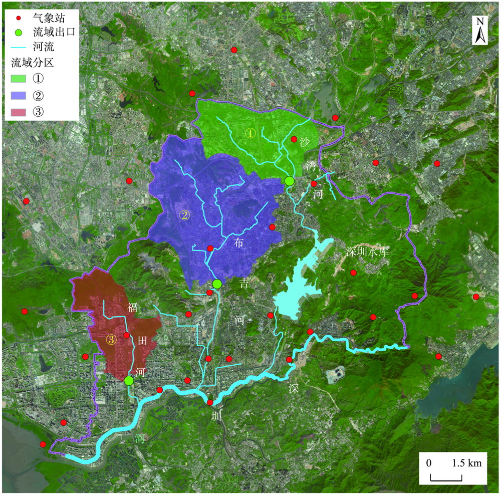
图1 深圳市深圳河流域的3个子流域范围注:背景影像来自百度在线地图( https://map.baidu.com)。 Fig. 1 The boundary of three sub watersheds of Shenzhen river watershed in Shenzhen |
表1 洪峰变化平均值统计Tab. 1 Average variation of flood peak for 3 basins (%) |
| 网格大小/m | |||||||
|---|---|---|---|---|---|---|---|
| 200 | 400 | 800 | 1600 | 3200 | 6400 | ||
| 洪峰变化均值 | 流域1 | 0.00 | -0.09 | -0.36 | -0.82 | -0.72 | -0.72 |
| 流域2 | 0.00 | -0.14 | -0.36 | -0.84 | -1.64 | -2.23 | |
| 流域3 | 0.00 | -0.03 | -0.24 | 0.16 | 0.27 | 0.99 | |
| 洪峰变化绝对值均值 | 流域1 | 0.00 | 0.27 | 0.81 | 1.76 | 2.89 | 5.04 |
| 流域2 | 0.00 | 0.20 | 0.56 | 1.46 | 2.82 | 8.73 | |
| 流域3 | 0.00 | 0.16 | 0.58 | 1.67 | 2.75 | 7.11 | |
| [1] |
欧阳晓, 朱翔. 中国城市群城市用地扩张时空动态特征[J]. 地理学报, 2020, 75(3):571-588.
[
|
| [2] |
杨传开, 宁越敏. 中国省际人口迁移格局演变及其对城镇化发展的影响[J]. 地理研究, 2015, 34(8):1492-1506.
[
|
| [3] |
庄琦, 刘曙光, 周正正. 上海城区降雨时空分布变化与暴雨频率分析[J]. 水文, 2021, 41(4):74-80.
[
|
| [4] |
刘家宏, 王浩, 高学睿, 等. 城市水文学研究综述[J]. 科学通报, 2014, 59(36):3581-3590.
[
|
| [5] |
谢映霞. 基于海绵城市建设理念的系统治水思路[J]. 北京师范大学学报(自然科学版), 2019, 55(5):552-555.
[
|
| [6] |
徐宗学, 陈浩, 任梅芳, 等. 中国城市洪涝致灾机理与风险评估研究进展[J]. 水科学进展, 2020, 31(5):713-724.
[
|
| [7] |
张建云, 王银堂, 贺瑞敏, 等. 中国城市洪涝问题及成因分析[J]. 水科学进展, 2016, 27(4):485-491.
[
|
| [8] |
朱焱, 杨金彪, 朱莲芳, 等. 苏州城市化进程与城市气候变化关系研究[J]. 气象科学, 2012, 32(3):317-324.
[
|
| [9] |
张建云, 宋晓猛, 王国庆, 等. 变化环境下城市水文学的发展与挑战-Ⅰ.城市水文效应[J]. 水科学进展, 2014, 25(4):594-605.
[
|
| [10] |
徐宗学, 叶陈雷. 城市暴雨洪涝模拟:原理、模型与展望[J]. 水利学报, 2021, 52(4):381-392.
[
|
| [11] |
|
| [12] |
|
| [13] |
刘成林, 周玉文, 隋军, 等. 城市排水防涝系统降雨空间分布特性研究[J]. 给水排水, 2016, 42(1):46-49.
[
|
| [14] |
陈光照, 侯精明, 张阳维, 等. 西咸新区降雨空间非一致性对内涝过程影响模拟研究[J]. 南水北调与水利科技, 2019, 17(04):37-45.
[
|
| [15] |
唐颖. 基于雷达估测降雨的城市内涝设计条件与实时模拟研究[D]. 北京: 北京工业大学, 2019.
[
|
| [16] |
城镇内涝防治技术规范(GB 51222-2017)[S]. 北京: 中国计划出版社, 2017.
[Technical code for urban flooding prevention and control(GB 51222-2017)[S]. Beijing: China Planning Press, 2017. ]
|
| [17] |
康钊菁, 王晓蕾, 刘波, 等. 小范围自然降雨空间均匀性的实测改进[J]. 解放军理工大学学报(自然科学版), 2017, 18(2):138-143.
[
|
| [18] |
|
| [19] |
李磊, 张立杰, 力梅. 深圳降水资料信息挖掘及在气候服务中的应用[J]. 广东气象, 2015, 37(2):48-51.
[
|
| [20] |
苗世光, 蒋维楣, 梁萍, 等. 城市气象研究进展[J]. 气象学报, 2020(3):477-499.
[
|
| [21] |
许沛华, 陈正洪, 李磊, 等. 深圳分钟降水数据预处理系统设计与应用[J]. 暴雨灾害, 2012, 31(1):83-86.
[
|
| [22] |
|
| [23] |
陈晓宏, 钟睿达, 王兆礼, 等. 新一代GPM IMERG卫星遥感降水数据在中国南方地区的精度及水文效用评估[J]. 水利学报, 2017, 48(10):1147-1156.
[
|
| [24] |
GB/T 28592-2012,降水量等级[S]. 北京: 中国标准出版社, 2012.
[GB/T 51222-2017,Grade of precipitation[S]. Beijing: Standards Press of China, 2012. ]
|
| [25] |
臧文斌. 城市洪涝精细化模拟体系研究[D]. 北京: 中国水利水电科学研究院, 2019.
[
|
| [26] |
林木生, 陈兴伟, 陈莹. 晋江西溪流域洪水与暴雨时空分布特征的相关分析[J]. 资源科学, 2011, 33(12):2226-2231.
[
|
| [27] |
温娅惠, 李致家, 孙明坤, 等. 降雨输入对实时洪水预报精度与预见期的影响[J]. 湖泊科学, 2019, 31(1):41-53.
[
|
/
| 〈 |
|
〉 |