
基于影响因子动态更新的都市圈国土-人口协同模拟
|
高 位(1997— ),江苏宿迁人,硕士生,研究方向为城市群空间模拟。E-mail: gaowei2020@email.szu.edu.cn |
收稿日期: 2022-01-05
修回日期: 2022-02-13
网络出版日期: 2022-10-25
基金资助
国家重点研发计划项目(2019YFB2103104)
国家自然科学基金项目(71961137003)
Synergistic Simulation of Land and Population in Metropolitan Area With Dynamic Influence Factors
Received date: 2022-01-05
Revised date: 2022-02-13
Online published: 2022-10-25
Supported by
National Key Research and Development Program(2019YFB2103104)
National Natural Science Foundation of China(71961137003)
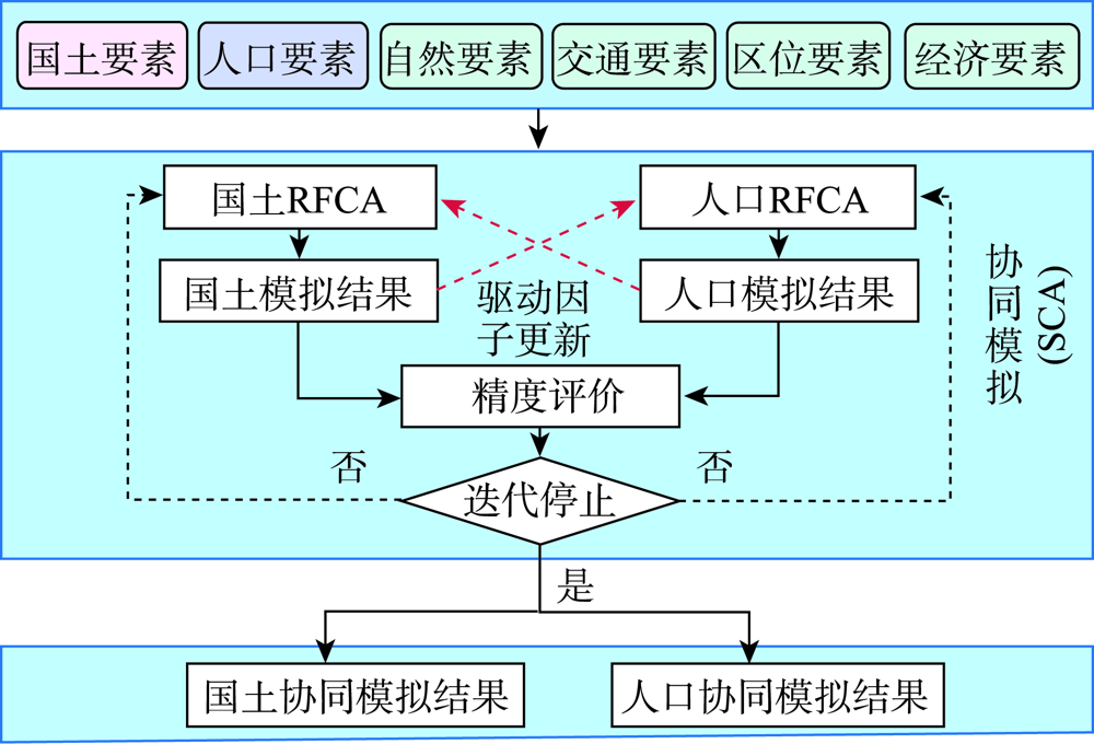
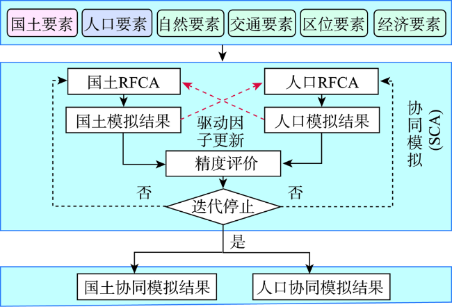
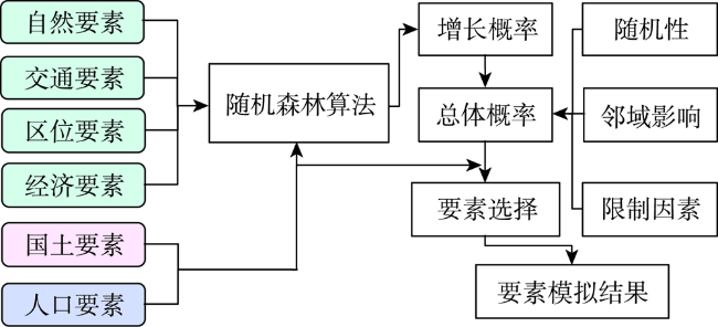
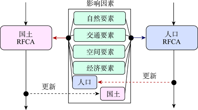
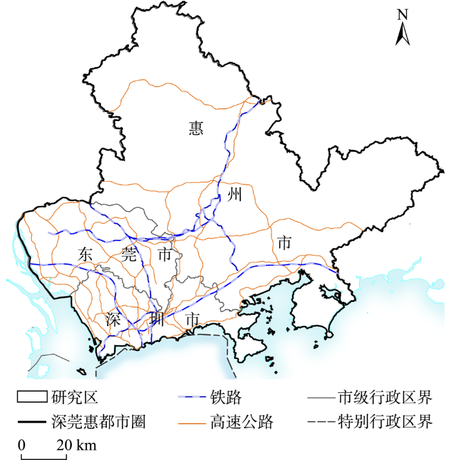
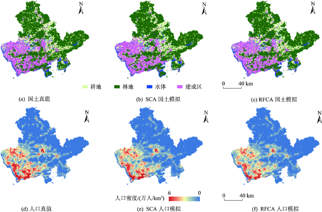
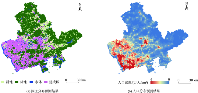
都市圈作为典型的复杂巨系统,其国土、人口、交通等要素呈现出共同演化、协同发展的特征。现有基于元胞自动机的空间模拟方法通常分别进行国土或人口模拟,忽略了国土、人口之间的协同演化,从而限制了模拟性能。本文提出一种影响因子动态更新策略用以表征国土、人口两种要素间的相互作用,拓展经典元胞自动机模型构建协同模拟算法,实现了都市圈国土与人口空间分布态势的精准模拟。本文以深莞惠都市圈为例,对提出算法进行了实验验证。实验结果表明,本文提出协同模拟算法在深莞惠都市圈的国土模拟品质因素为0.274、人口模拟平均绝对百分比误差23.55%,分别优于传统基于随机森林的元胞自动机算法0.24和29.33%;相较于传统模型,在国土模拟中本模型在对于建设用地的模拟准确度提升了约3%,在人口模拟中本模型在对人口高密度的区域模拟误差降低了约6%。本文进一步预测了深莞惠都市圈2030年国土和人口发展空间态势。研究结果可为都市圈重大基础设施选址和发展情景推演提供技术支撑。
高位 , 涂伟 , 李明晓 , 方碧宸 , 陈栋胜 , 黄正东 , 贺彪 . 基于影响因子动态更新的都市圈国土-人口协同模拟[J]. 地球信息科学学报, 2022 , 24(8) : 1502 -1511 . DOI: 10.12082/dqxxkx.2022.220008
Metropolitan area is a typical complex system with co-evolution and coordinated development of land, population, and transportation. It has become an urgent issue to guide the development path of metropolitan area scientifically by coordinating the territorial space and human resources in metropolitan area. Cellular automata is a discrete grid dynamic model. By constructing simple transformation rules, combined with strong spatial modeling ability and computing ability, it has become an effective means to study complex urban systems. However, existing cellular automata-driven spatial simulation methods usually simulate land or population separately. Their performance are limited as they ignore the co-evolution between land and population. This paper proposes the dynamic influence factors to characterize the interaction between land and population. The core idea is to take the simulation results of land and population as the influence factors of new cellular automata, and express the complex driving processes of land change and population change by updating the cell transformation probability. The spatial simulation model is repeatedly trained to describe the synergistic evolution between land and population in the process of development. The classical cellular automata model is then extended to construct a synergistic simulation framework which realizes the accurate spatial simulation of land and population in the metropolitan area. Taking the Shenzhen-Dongguan-Hui metropolitan area as an example, the experiment was conducted to verify the proposed method. The results show that the synergistic simulation algorithm can accurately simulate the land and population development processes. The simulation results of the proposed algorithm show a Figure of Merit of 0.274 for land and Mean Absolute Percentage Error of 23.55% for population, which outperfoms the traditional cellular automata algorithm coupled with random forest (Figure of Merit = 0.24, and Mean Absolute Percentage Error = 29.33%). Compared with traditional models, the simulation accuracy of this model for construction land is improved by about 3% in land simulation, and the simulation error of this model for high-density population area is reduced by about 6% in population simulation. We further predict the spatial scenario of the land and population development of the Shenzhen-Dongguan-Hui Metropolitan Area in 2030. The results show that the expansion of construction land mainly occurs in the undeveloped areas with good infrastructure (such as Huizhou area), the population further gathers in the high-density areas, and the growth is mainly concentrated in the core urban areas of the metropolitan area. These results provide technical support for locating important infrastructure facilities and development scenarios simulation in the metropolitan area.
表1 本文研究所用数据说明Tab.1 Data description |
| 类别 | 数据名称 | 时间 | 空间分辨率 | 数据来源 |
|---|---|---|---|---|
| 要素 | 土地利用 | 2000—2020年 | 30 m | GlobalLand30 |
| 人口 | 2000—2020年 | 1 km | GPW | |
| 自然要素 | DEM | 2008年 | 1 km | NASA |
| 坡度 | 2020年 | 1 km | 由DEM计算得到 | |
| 交通要素 | 到火车站距离 | 2020年 | 1 km | 高德地图API |
| 到公路距离 | 2020年 | 1 km | 高德地图API | |
| 区位要素 | 到市中心距离 | 2020年 | 1 km | 高德地图API |
| 到区县中心距离 | 2020年 | 1 km | 高德地图API | |
| 到水系距离 | 2020年 | 1 km | 高德地图API | |
| 经济要素 | 国民经济总值 | 2015年 | 1 km | 中国科学院地理科学与资源研究所 |
表2 SCA方法与RFCA方法模拟结果对比Tab. 2 Comparison of simulation results of the SCA algorithm and the RFCA algorithm |
| 要素 | 算法 | FoM | MAPE | Kappa | RMSE |
|---|---|---|---|---|---|
| 国土 | SCA | 0.274 | - | 0.832 | - |
| RFCA | 0.242 | - | 0.821 | - | |
| 人口 | SCA | - | 23.55% | - | 5.816 |
| RFCA | - | 29.33% | - | 8.710 |
注:加粗字体表示该方法比传统方法精度更高。 |
表3 不同城市人口模拟结果比较Tab. 3 The population simulation results in different cities(%) |
| 深圳 | 东莞 | 惠州 | |
|---|---|---|---|
| SCA | 33.29 | 11.08 | 21.88 |
| RFCA | 41.55 | 18.99 | 24.90 |
| [1] |
方创琳. 中国城市群研究取得的重要进展与未来发展方向[J]. 地理学报, 2014, 69(8):1130-1144.
[
|
| [2] |
解学梅. 协同创新效应运行机理研究:一个都市圈视角[J]. 科学学研究, 2013, 31(12):1907-1920.
[
|
| [3] |
|
| [4] |
中共中央, 国务院. 国家新型城镇化规划(2014-2020)[R]. 新华社, 2014-03-16.
[The CPC Central Committee, The State Council. National New Urbanization Plan (2014-2020)[R]. Xinhua News Agency, 2014-03-16. ]
|
| [5] |
黄正东,
[
|
| [6] |
|
| [7] |
|
| [8] |
周成虎, 孙战利, 谢一春. 地理元胞自动机[M]. 北京: 科学出版社, 1999.
[
|
| [9] |
黎夏, 叶嘉安. 基于神经网络的元胞自动机及模拟复杂土地利用系统[J]. 地理研究, 2005, 24(1):19-27.
[
|
| [10] |
陈逸敏, 黎夏. 机器学习在城市空间演化模拟中的应用与新趋势[J]. 武汉大学学报·信息科学版, 2020, 45(12):1884-1889.
[
|
| [11] |
|
| [12] |
赵林峰, 刘小平, 刘鹏华, 等. 基于地理分区与FLUS模型的城市扩张模拟与预警[J]. 地球信息科学学报, 2020, 22(3):517-530.
[
|
| [13] |
|
| [14] |
王家丰, 王蓉, 冯永玖, 等. 顾及轨道交通影响的浙中城市群土地利用多情景模拟与分析[J]. 地球信息科学学报, 2020, 22(3):605-615.
[
|
| [15] |
|
| [16] |
黎夏, 叶嘉安. 基于元胞自动机的城市发展密度模拟[J]. 地理科学, 2006, 26(2):165-172.
[
|
| [17] |
|
| [18] |
黎夏, 叶嘉安, 刘小平, 等. 地理模拟系统:元胞自动机与空间智能[M]. 北京: 科学出版社, 2020.
[
|
| [19] |
周艳, 黄贤金, 徐国良, 等. 长三角城市土地扩张与人口增长耦合态势及其驱动机制[J]. 地理研究, 2016, 35(2):313-324.
[
|
| [20] |
吴一凡, 刘彦随, 李裕瑞. 中国人口与土地城镇化时空耦合特征及驱动机制[J]. 地理学报, 2018, 73(10):1865-1879.
[
|
| [21] |
张大川, 刘小平, 姚尧, 等. 基于随机森林CA的东莞市多类土地利用变化模拟[J]. 地理与地理信息科学, 2016, 32 (5):29-36.
[
|
| [22] |
|
| [23] |
|
| [24] |
|
| [25] |
|
| [26] |
中华人民共和国自然资源部. 30米全球地表覆盖数据[DB/OL]. http://www.globallandcover.com,2020-09-26.
[Ministry of Natural Resources of the People's Repubilc of China. Global Land Cover in 30m[DB/OL]. http://www.globallandcover.com,2020-09-26.
|
| [27] |
中华人民共和国住房和城乡建设部. 城市用地分类与规划建设用地标准[S]. 2011.
[Ministry of Housing and Urban-Rural Development of the People's Republic of China. Code for classification of urban and rural land use and planning standards of development land[S]. 2011. ]
|
| [28] |
Center for International Earth Science Information Network-CIESIN-Columbia University. 2018. Gridded population of the world, version 4.11 (GPWv4)[DB/OL]. https://sedac.ciesin.columbia.edu/data/set/, 2020-01-01.
|
| [29] |
|
| [30] |
Tran,
|
| [31] |
涂伟, 曹劲舟, 高琦丽, 等. 融合多源时空大数据感知城市动态[J]. 武汉大学学报·信息科学版, 2020, 45(12):1875-1883.
[
|
| [32] |
刘小平, 黎夏, 叶嘉安, 等. 利用蚁群智能挖掘地理元胞自动机的转换规则[J]. 中国科学(D 辑:地球科学), 2007, 37(6):824-834.
[
|
| [33] |
|
/
| 〈 |
|
〉 |