
基于Sentinel-1/2动态耦合移栽期特征的水稻种植模式识别
|
甘聪聪(1996— ),男,江西丰城人,硕士研究生,主要从事农业遥感研究。E-mail: 1964349104@qq.com |
收稿日期: 2022-07-21
修回日期: 2022-10-20
网络出版日期: 2023-03-25
基金资助
国家自然科学基金项目(42171325)
国家自然科学基金项目(41771468)
福建省科技厅产学研项目(2020N5002)
福建省自然资源科学创新项目(KY-010000-04-2022-002)
Mapping Paddy Rice Planting Patterns based on Sentinel-1/2
Received date: 2022-07-21
Revised date: 2022-10-20
Online published: 2023-03-25
Supported by
National Natural Science Foundation of China(42171325)
National Natural Science Foundation of China(41771468)
Science Bureau of Fujian Province(2020N5002)
Fujian Natural Resources Science Innovation Project(KY-010000-04-2022-002)
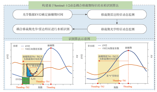
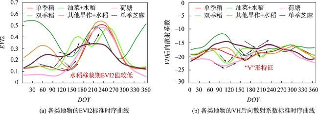
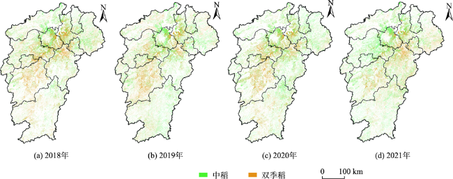
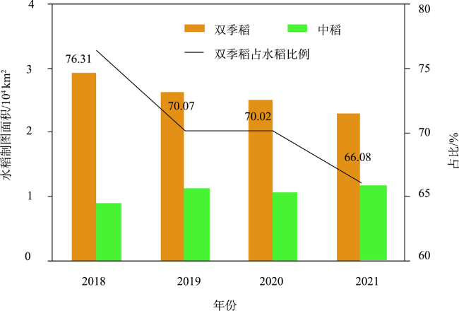
及时准确地获取水稻种植模式变化对于有效防控“非粮化”和完成“双碳”目标具有重要意义。现有研究多基于固定时间窗口挖掘水稻生长期特征,且多使用的是单一卫星影像数据,难以应用于大范围水稻制图。本文通过Sentinel-1/2数据构建动态窗口提取移栽期光学/雷达特征,利用其耦合关系实现水稻种植模式制图。将该算法应用于湖南和江西两省水稻制图。基于1402个地面参考点位对水稻提取结果进行验证,总体精度达92.80%;在县域尺度上,湖南和江西两省水稻制图面积与农业统计数据也具有高度一致性,R2达0.85以上。相比于用固定窗口进行水稻特征提取,该方法具有较强的鲁棒性和迁移能力,为实现更大范围作物制图提取提供新的思路和参考依据。2018—2021年江西省水稻制图结果表明,水稻总种植面积减少9.47%,约3460 km2,水稻种植强度从1.62下降至1.49;在种植模式上,“双改中”趋势明显,双季稻种植面积锐减21.61%,其中约84%改种中稻。
关键词: 水稻; 遥感; Google Earth Engine; Sentinel-1/2; 移栽期; 物候; “V”形特征; 动态窗口
甘聪聪 , 邱炳文 , 张建阳 , 姚铖鑫 , 叶智燕 , 黄姮 , 黄莹泽 , 彭玉凤 , 林艺真 , 林多多 , 苏中豪 . 基于Sentinel-1/2动态耦合移栽期特征的水稻种植模式识别[J]. 地球信息科学学报, 2023 , 25(1) : 153 -162 . DOI: 10.12082/dqxxkx.2023.220532
Accurate and timely spatiotemporal change information of rice planting patterns is significant for effectively preventing "no-grain" and achieving carbon peak and carbon neutrality goals. However, it is challenging to establish a rice mapping method at large spatial domain. This study developed a novel paddy rice planting mapping method based on dynamic coupling optical/radar features of transplanting period. The proposed algorithm was applied to paddy rice mapping in Jiangxi and Hunan province. The derived paddy rice planting map was evaluated using 1402 ground reference sites, and it had an overall accuracy of 92.80%. The paddy rice planting area was also highly consistent with the agricultural census data (R2 > 0.85) at the county level. Compared with rice feature extraction using a fixed window, the proposed method has strong robustness and migration ability, and provides a new idea and reference for crop mapping at large spatial domain. The result showed that the paddy rice planting area in Jiangxi province decreased by 3460 km2 (9.47%) from 2018 to 2021. The rice cropping intensity in Jiangxi province had decreased by 0.13 due to the change of double-cropping rice to medium rice. The double-cropping rice planting area decreased by 21.61%, with 84% shifted to single cropping rice.
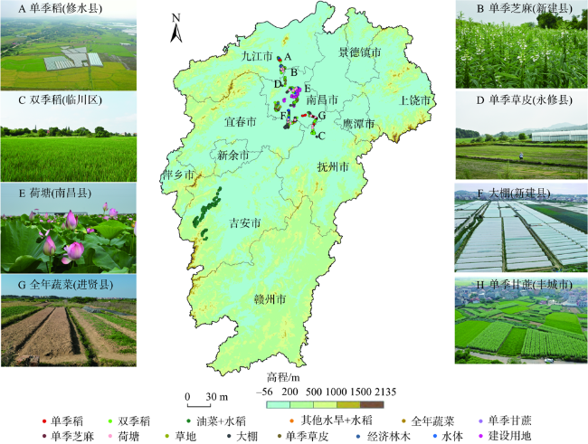
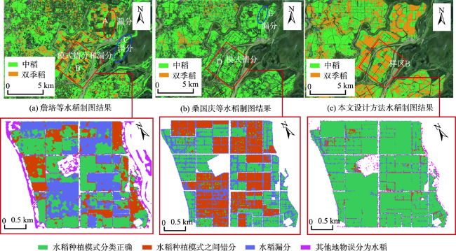
图3 研究区实地调研点及地物类型空间分布Fig. 3 Field research points and spatial distribution of ground object types in the study area |
表1 耕地参考点数量Tab. 1 Reference point number (个) |
| 作物类别 | 点位数 | 作物类别 | 点位数 | 作物类别 | 点位数 | 作物类别 | 点位数 |
|---|---|---|---|---|---|---|---|
| 单季稻 | 631 | 全年蔬菜 | 54 | 其他旱作+水稻 | 86 | 单季草皮 | 67 |
| 双季稻 | 587 | 荷塘 | 69 | 单季芝麻 | 33 | 大棚 | 91 |
| 油菜+水稻 | 356 | 经济林木 | 36 | 单季甘蔗 | 13 | 总数 | 2023 |
表2 水稻识别结果精度验证Tab. 2 Rice identification result accuracy verification |
| 双季稻 | 中稻 | 其他 | 生产者精度/% | F1/% | |
|---|---|---|---|---|---|
| 双季稻 | 169/76/99 | 3/33/58 | 4/67/19 | 96.02/43.18/56.25 | 88.25/46.91/55.31 |
| 中稻 | 8/42/58 | 301/255/236 | 13/25/28 | 93.48/79.19/73.29 | 89.99/74.45/72.84 |
| 其他 | 35/30/25 | 38/75/32 | 831/779/847 | 91.92/88.12/93.69 | 94.86/88.77/94.22 |
| 用户精度/% | 81.64/51.35/54.40 | 86.74/70.25/72.39 | 97.80/89.44/94.74 | ||
| 总体精度/% | 92.80/80.32/84.31 | ||||
| Kappa系数 | 0.8698/0.6661/0.7212 |
注:对于每个单元格num1/num2/num3分别表示使用本文方法、詹培等方法和桑国庆等方法精度指标。 |
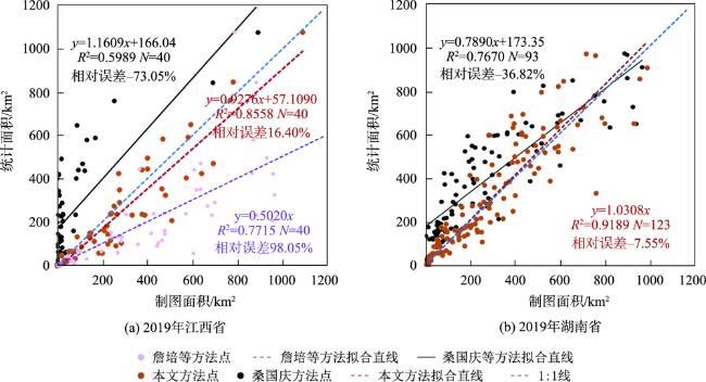
图6 2019年稻制图面积与统计数据面积对比Fig. 6 Comparison of double-cropping rice mapping area and statistical data area in 2019 |
表3 2019年江西省和湖南省散点图验证参数Tab. 3 Validation parameters for scatter plots in Jiangxi Provinces and Hunan Provinces in 2019 |
| 散点图验证区域 | 验证方法 | 线性拟合曲线 | 决定系数R2 | 相对误差/% | 样本个数/个 |
|---|---|---|---|---|---|
| 2019年江西省 | 詹培等方法 | y=0.5020x | 0.7715 | 98.05 | 40 |
| 桑国庆等方法 | y=1.1609x+166.04 | 0.5989 | -73.05 | 40 | |
| 本文方法 | y=0.9276x+57.1090 | 0.8558 | 16.40 | 40 | |
| 2019年湖南省 | 桑国庆等方法 | y=0.7890x+173.35 | 0.7890 | -36.82 | 93 |
| 本文方法 | y=1.0308x | 0.9189 | -7.55 | 123 |
| [1] |
|
| [2] |
|
| [3] |
|
| [4] |
|
| [5] |
|
| [6] |
|
| [7] |
|
| [8] |
|
| [9] |
|
| [10] |
|
| [11] |
|
| [12] |
|
| [13] |
|
| [14] |
|
| [15] |
|
| [16] |
|
| [17] |
|
| [18] |
|
| [19] |
|
| [20] |
桑国庆, 唐志光, 毛克彪, 等. 基于GEE云平台与Sentinel数据的高分辨率水稻种植范围提取——以湖南省为例[J]. 作物学报, 2022, 48(9):2409-2420.
[
|
| [21] |
|
| [22] |
|
| [23] |
张伟, 李玮, 陶冠宏, 等. 利用STARFM模型提高复杂地表下复种指数遥感提取精度[J]. 农业工程学报, 2020, 36(21):175-185.
[
|
| [24] |
邱炳文, 闫超, 黄稳清. 基于时序遥感数据的农作物种植制度研究进展与展望[J]. 地球信息科学学报, 2022, 24(1):176-188.
[
|
| [25] |
|
| [26] |
|
/
| 〈 |
|
〉 |