
基于开源数据和条件生成对抗网络的地形重建方法
|
陈 凯(1999— ),男,甘肃天水人,硕士生,研究方向为实景三维建模与数字地形分析。E-mail: 20211210002@nuist.edu.cn |
收稿日期: 2022-09-19
修回日期: 2022-10-31
网络出版日期: 2023-04-19
基金资助
江苏省高等学校自然科学研究项目(22KJB170016)
国家自然科学基金项目(42101384)
江苏省自然科学基金青年基金项目(BK20210043)
安徽高校省级自然科学研究重大项目(KJ2021ZD0130)
江西省水利厅重大科技项目(202124ZDKT29)
“实景地理环境安徽省重点实验室”开放课题资助(2022PGE013)
Terrain Rebuilding Method based on Open Source Data and Conditional Generative Adversarial Networks
Received date: 2022-09-19
Revised date: 2022-10-31
Online published: 2023-04-19
Supported by
The Natural Science Foundation of the Jiangsu Higher Education Institutions of China(22KJB170016)
The National Natural Science Foundation of China, No.42101384(42101384)
The Natural Science Foundation of Jiangsu Province(BK20210043)
The Major Project of Natural Science Research of Anhui Provincial Department of Education(KJ2021ZD0130)
The Water Conservancy Science and Technology Project of Jiangxi Province(202124ZDKT29)
The Foundation of Anhui Province Key Laboratory of Physical Geographic Environment(2022PGE013)
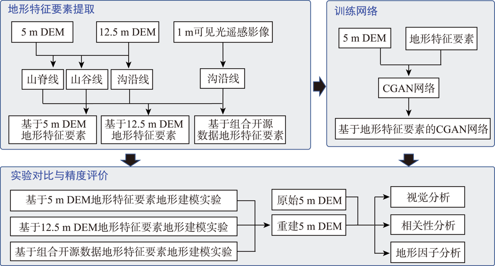
如何使用少量的地形特征复原地形地貌一直为地学领域的难题。本文使用开源数据集提取地形特征要素,使用地形特征要素作为约束条件构建了用于生成DEM的条件生成对抗网络(Conditional Generative Adversarial Networks, CGAN),设计了基于开源DEM、开源DEM与遥感影像组合、以及5m高精度DEM提取地形特征要素生成DEM的对比实验,并对结果进行视觉效果、相关性分析以及地形因子的对比与评价。结果表明:① 在视觉效果上,3种不同方式生成的DEM在视觉效果上均十分逼近原始5 m DEM,都远好于传统插值方法生成DEM,基于开源12.5m DEM提取要素和1m遥感影像的重建效果最接近于原始5 m DEM;② 在相关性上,三种不同方式生成的DEM与原始5m DEM相关性均能达到0.75以上,组合开源数据提取要素重建DEM与原始5 m DEM相关性可达到0.85以上;③ 在地形因子方面,基于开源12.5 m DEM和1 m遥感影像提取要素重建DEM的坡度和坡向的分布趋势与原始5 m DEM最为一致。本文为高精度DEM建模提供了新的思路,在高精度DEM难以获取的区域,可以利用开源数据集和条件生成对抗网络进行高精度地形建模,从而进行地学分析和地理模拟等。

陈凯 , 雷少华 , 代文 , 王春 , 刘爱利 , 李敏 . 基于开源数据和条件生成对抗网络的地形重建方法[J]. 地球信息科学学报, 2023 , 25(2) : 252 -264 . DOI: 10.12082/dqxxkx.2023.220701
How to use a small number of topographic features to restore the topography has been a difficult problem in the field of geology. In this paper, we extract topographic features from open source datasets, and construct Conditional Generative Adversarial Networks (CGAN) for DEM generation using topographic features as constraints, a comparative experiment was designed based on the combination of open-source DEM, open-source DEM and remote sensing image, as well as the generation of DEM by extracting topographic features from the high-precision DEM with a resolution of 5 m, the results were compared and evaluated by visual effect, correlation analysis and topographic factors. The results show that: (1) in the visual effect, the DEM generated by three different methods are very close to the original DEM with a resolution of 5m, which is much better than the traditional interpolation method, (2) the correlation between DEM generated by three different methods and the original DEM with a resolution of 5m is more than 0.75, and the result of reconstruction based on dem with a resolution of 5 m extracted from open source and remote sensing image with a resolution of 1m is closest to that of the original DEM with a resolution of 5m, the correlation between DEM and original 5m DEM can reach more than 0.85. (3) in the aspect of terrain factor, based on dem with a resolution of 5 m and remote sensing image with a resolution of 1m, the distribution trend of slope and aspect of reconstructed DEM is most consistent with the original DEM with a resolution of 5 m. This paper provides a new idea for high-precision DEM modeling. In the areas where high-precision DEM is difficult to obtain, high-precision terrain modeling can be carried out by using open source data sets and Conditional Generative Adversarial Networks, so as to conduct geoscience analysis and geographical simulation.

表1 基于不同数据源地形特征要素的CGAN地形重建实验Tab.1 The experiment of CGAN terrain reconstruction based on different terrain features from different data sources |
| 序号 | 实验名称 | 实验目的 |
|---|---|---|
| 1 | 基于5 m DEM地形特征要素的地形重建生成实验 | 作为对照组,评估网络模型精度 |
| 2 | 基于12.5 m DEM地形特征要素的地形重建实验 | 探究单一低分辨率开源DEM数据地形特征要素生成高分辨率地形的效果 |
| 3 | 基于1 m遥感影像+12.5 m DEM组合开源数据 地形重建实验 | 1 m遥感影像可以提高沟沿线精度,因此将其组合;探究组合开源数据地形特征要素生成高分辨率地形的效果 |
表2 3种重建方法重建效果总结Tab.2 The submersions of three rebuilding methods |
| ① 基于5 m地形特征要素的重建 | ② 基于12.5 m地形特征要素的重建 | ③ 基于组合开源地形特征要素的重建 | ||
|---|---|---|---|---|
| 视觉效果 | ③ > ① > ② | |||
| 高程相关性 | 0.87~0.96 | 0.77~0.92 | 0.83~0.96 | |
| 地形因子 | 坡度分布 | ③ > ① > ② | ||
| 坡向分布 | ③ > ①> ② | |||
| [1] |
徐亚莉, 罗明良, 梁倍瑜, 等. DEM空间插值方法对土壤侵蚀模拟的影响研究——以USPED分析干热河谷典型冲沟为例[J]. 地理科学进展, 2016, 35(7):870-877.
[
|
| [2] |
陈传法, 岳天祥. 基于条件随机模拟的DEM误差分析——以董志塬水土流失等级划分为例[J]. 地球信息科学学报, 2009, 11(5):5572-5576.
[
|
| [3] |
兰进京, 于海洋, 陈琳, 等. 机载LiDAR DEM在流域水文分析与模拟中的尺度效应[J]. 测绘通报, 2020(4):40-46.
[
|
| [4] |
|
| [5] |
王金鑫, 秦子龙, 赵光成, 等. 基于球体网格与DEM的流域地形特征尺度效应分析——以长江流域为例[J]. 应用基础与工程科学学报, 2022, 30(5):1109-1120.
|
| [6] |
|
| [7] |
毛玉辉, 宋众艳, 岳忠奇, 等. 灰度图在地形建模中的应用[J]. 火力与指挥控制, 2019, 44(11):160-164.
[
|
| [8] |
徐建华, 顾浩, 曾艳阳, 等. 自适应屏幕分辨率的海底地形建模研究[J]. 计算机仿真, 2022, 39(4):142-145.
[
|
| [9] |
代文, 那嘉明, 杨昕, 等. 基于DEM光照晕渲模拟的梯田自动提取方法[J]. 地球信息科学学报, 2017, 19(6):754-762.
[
|
| [10] |
毕瑞, 甘淑, 李绕波, 等. 面向东川复杂山地泥石流沟谷三维地形建模及特征分析的无人机遥感探测应用研究[J]. 中国地质灾害与防治学报, 2021, 32(3):91-100.
[
|
| [11] |
|
| [12] |
李清, 侯永军, 沈春林. 数字地形数据的二维三次卷积插值[J]. 南京航空航天大学学报, 1997, 29(4):378-384.
[
|
| [13] |
刘世彬, 刘兴彦. 最小二乘内插数学模型生成虚拟地形的可视化研究[J]. 计算机工程与科学, 2008, 30(9):29-31.
[
|
| [14] |
刘世彬, 刘兴彦. 多面函数内插数学模型生成虚拟地形的可视化研究[J]. 火力与指挥控制, 2009, 34(9):28-30.
[
|
| [15] |
王耀革, 王鑫, 朱长青. 基于双线性内插规则格网DEM地形误差模型[J]. 测绘科学技术学报, 2007, 24(6):419-421.
[
|
| [16] |
|
| [17] |
|
| [18] |
|
| [19] |
|
| [20] |
|
| [21] |
江西林, 王少荣, 李文玉, 等. 以特征线和高程范围为约束的DEM-cGAN框架[J]. 计算机辅助设计与图形学学报, 2021, 33(8):1191-1201.
[
|
| [22] |
|
| [23] |
|
| [24] |
唐贤伦, 杜一铭, 刘雨微, 等. 基于条件深度卷积生成对抗网络的图像识别方法[J]. 自动化学报, 2018, 44(5):855-864.
[
|
| [25] |
张勇. 黄土高原地面坡谱研究[D]. 西安: 西北大学, 2003.
[
|
| [26] |
代文, 汤国安, 胡光辉, 等. 基于无人机摄影测量的地形变化检测方法与小流域输沙模型研究[J]. 地理科学进展, 2021, 40(9):1570-1580.
[
|
| [27] |
王静, 张军, 代文, 等. 黄土高原县域贫困空间格局及地形影响因素研究[J]. 地域研究与开发, 2020, 39(3):30-35,52.
[
|
| [28] |
晏实江, 汤国安, 李发源, 等. 利用DEM边缘检测进行黄土地貌沟沿线自动提取[J]. 武汉大学学报·信息科学版, 2011, 36(3):363-367.
[
|
| [29] |
李可. 基于深度学习的虚拟地形生成方法研究[D]. 南京: 南京师范大学, 2019.
[
|
| [30] |
朱红春, 汤国安, 张友顺, 等. 基于DEM提取黄土丘陵区沟沿线[J]. 水土保持通报, 2003, 23(5):43-45,61.
[
|
| [31] |
|
| [32] |
|
| [33] |
张磊, 汤国安, 李发源, 等. 黄土地貌沟沿线研究综述[J]. 地理与地理信息科学, 2012, 28(6):44-48.
[
|
/
| 〈 |
|
〉 |