
基于POI大数据的开封市城市功能扩张与演替特征分析
|
张慧馨(1998— ),女,河南安阳人,硕士生,主要从事大数据与城市规划研究。E-mail: zhanghx@henu.edu.cn |
收稿日期: 2022-06-23
修回日期: 2022-10-08
网络出版日期: 2023-04-19
基金资助
国家自然科学基金项目(42071294)
国家自然科学基金项目(42171295)
河南省优秀青年科学基金项目(222300420030)
河南省哲学社会科学规划项目(2020BJJ019)
河南省高等学校人文社会科学研究项目(2021-ZDJH-057)
Spatial Expansion and Succession Characteristics of Urban Function in Kaifeng City based on POI Big Data
Received date: 2022-06-23
Revised date: 2022-10-08
Online published: 2023-04-19
Supported by
National Natural Science Foundation of China(42071294)
National Natural Science Foundation of China(42171295)
Provincial Natural Science Foundation for Outstanding Scholars of Henan(222300420030)
Philosophy and Social Science Planning Project of Henan Province(2020BJJ019)
Humanities and Social Science Research Project of the Higher Education of Henan Province(2021-ZDJH-057)
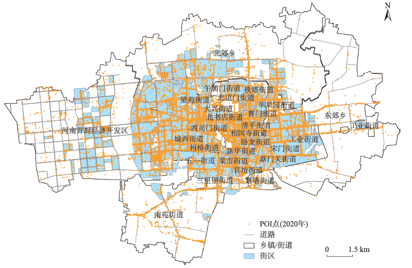
以POI为代表的社会感知数据为精细尺度城市空间结构研究提供了新思路,然而,POI数据与传统光学遥感数据的关系、长时序POI数据表征的城市功能空间扩张与演替特征还有待进一步挖掘。因而,本文以开封市主城区为例,采用2005—2020年POI数据,通过构建城市街区尺度功能集聚-扩散分析框架,利用空间统计指标和区位熵指数分析城市功能的演替特征与复合功能变化。结果发现:① 2005—2020年开封市城市社会经济活动呈逐渐增长的扩张态势,活动空间的面积扩张了11.26 km2,年均扩张速度由2005—2015年的3.5%提升至2015—2020年的5.1%;② 城市各种活动的集聚、扩散过程造成不同功能的演替变化,其中开封市商服功能集聚程度较高,虽然受到新城区商业中心扩散的影响,单中心的城市发展模式依然没有发生变化;③ 具有复合功能的城市街区不断增多,对单中心的城市结构形成有益支撑。复合功能较强的街区主要分布在活力高、居民生活较为便捷的区域。本研究不仅能为城市空间规划的研究提供理论和技术支撑,也为城市更新、可持续发展以及国土空间规划提供新的思路。
张慧馨 , 张丽君 , 秦耀辰 , 王静帆 , 段杰冉 , 田梦男 . 基于POI大数据的开封市城市功能扩张与演替特征分析[J]. 地球信息科学学报, 2023 , 25(3) : 560 -672 . DOI: 10.12082/dqxxkx.2023.220434
The social sensing data such as POI provides new insights into fine-scale urban spatial structure study. However, the relationship between POI data and traditional remote sensing data needs to be further explored. Moreover, due to limited long-term POI data, the study on spatial expansion and succession characteristics of urban functions is still relatively rare. Therefore, this article took the main urban area of Kaifeng City as an example and used POI data between 2005 and 2020 to analyze the succession characteristics of urban functions and composite function changes. An analytical framework on spatial agglomeration and diffusion of urban functions was constructed to investigate the spatial process of human activity at block scale. Spatial statistical indicators and location entropy indices were used to analyze the characteristics of urban function succession and compound function change. The results show that: (1) Urban socioeconomic activities in Kaifeng showed a gradual expansion trend, and the area of activity space expanded by 11.26 km2 from 2005 to 2020. The average annual expansion rate increased from 3.5% during 2005 to 2015 to 5.1% during 2015 to 2020. POI data are more sensitive than remote sensing data on succession characteristics of activity spaces. (2) The process of agglomeration and diffusion of various urban activities results in the succession and change of different functions. Especially, Kaifeng has a relatively high degree of agglomeration for commercial service functions. Among them, the degree of agglomeration of commercial service functions in Kaifeng is relatively high. Although affected by the diffusion of commercial centers in new urban areas, the single-center urban development mode still does not change. The public administration and public service functions also show a central peripheral structure clustered in the old town, and the functional supply of the new urban areas needs to be improved. The residential function gradually changes from a relatively balanced functional configuration to agglomeration distribution, and the separation of employment and housing become more and more obvious. The overall industrial function gradually shifts from dispersion to agglomeration, spreading and moving from the central urban areas to the peripheral areas as a result of the policy on eliminating secondary and advancing tertiary industries, and then rapidly agglomerating together; (3) The number of urban blocks with commercial services and business offices is increasing, but the specialization advantages of business office functions are more prominent. And the number of urban blocks with complex functions is also increasing, which provides useful support for the single-center urban structure. The above results demonstrate that urban blocks with strong complex functions are mainly distributed in areas with high vitality and more convenient living residents. This research can not only provide theoretical and technical support for the study of urban spatial planning, but also provide new ideas for urban renewal, sustainable development and territorial space planning.
表1 POI类型划分体系Tab. 1 POI classification system |
| 功能类型 | 编号 | 用地类型 | 主题词 |
|---|---|---|---|
| 公共管理与公共服务 | 1 | 行政办公 | 机关单位、政府、公检法、党派团体…… |
| 2 | 文化设施 | 图书馆、展览馆、博物馆、文化宫、美术馆…… | |
| 3 | 教育科研 | 幼儿园、成人教育、高等教育、小学、中学、科研机构…… | |
| 4 | 体育设施 | 体育馆、游泳馆…… | |
| 5 | 医疗卫生 | 综合医院、专科医院、防疫站、卫生院、急救中心…… | |
| 6 | 其他公共服务 | 福利机构、文物古迹、宗教寺庙、养老院、孤儿院…… | |
| 商业服务业 | 7 | 商业设施 | 小吃快餐店、蛋糕甜品店、咖啡厅、西餐厅、中餐厅、酒吧、宾馆、酒店、快捷酒店、旅馆、民宿、商场、购物中心、超市、便利店、风景区、游乐园、营业厅、美容美发…… |
| 8 | 商务办公 | 银行、证券公司、保险公司、信用社、投资理财、新闻出版、广播电视、旅行社、事务所…… | |
| 9 | 娱乐康体设施 | 电影院、剧院、网吧、KTV、剧院、洗浴按摩…… | |
| 10 | 公共设施营业网点 | 加油站、加气站、电信、移动、联通、邮政营业网点…… | |
| 11 | 其他服务设施 | 培训机构、汽车维修、私人诊所、汽车美容…… | |
| 工业 | 12 | 工业 | 机械制造、冶金化工、纺织工业、食品加工、家居建材…… |
| 居住 | 13 | 居住 | 小区、别墅、家属院…… |
| 物流仓储 | 14 | 物流仓储 | 物流速递、快递点、仓储、仓库…… |
| 道路与交通 | 15 | 道路与交通设施 | 公交站、公共停车场、火车站、汽车站、高铁站…… |
| 公用设施 | 16 | 公用设施 | 水电站、环境设施、邮政支局…… |
| 绿地与广场 | 17 | 绿地与广场 | 公园、广场、绿地…… |
表2 随机抽取样本数据Tab 2 Random sample data |
| ID | FID | 编号 | POI点名称 |
|---|---|---|---|
| 52 | 26525 | a | 未来美好家园 |
| 26812 | j | 沐乐幼儿园 | |
| 138 | 17117 | k | 盼盼木门 |
| 210 | 21138 | c | 开封新区卫生局卫生监督所 |
| 26259 | b | 彭记宫廷糕点 | |
| 365 | 47148 | e | 开封市顺河区姚永军诊所 |
| 47711 | d | 开封空分集团有限公司(公园路) | |
| 457 | 3541 | f | 集英花园 |
| 4111 | h | 开封市晋安小学 | |
| 581 | 18758 | g | 岁岁羊(黄河路店) |
| 22945 | i | 城市花园(西环城路北段) |
| [1] |
|
| [2] |
|
| [3] |
|
| [4] |
薛东前, 万斯斯, 马蓓蓓, 等. 基于城市功能格局的西安市文化产业空间集聚研究[J]. 地理科学, 2019, 39(5):750-760.
[
|
| [5] |
叶强, 莫正玺, 许乙青. 1979—2014年长沙市城市功能用地扩展与驱动力研究[J]. 地理研究, 2019, 38(5):1063-1079.
[
|
| [6] |
|
| [7] |
|
| [8] |
|
| [9] |
|
| [10] |
|
| [11] |
|
| [12] |
|
| [13] |
|
| [14] |
|
| [15] |
|
| [16] |
|
| [17] |
|
| [18] |
|
| [19] |
陈世莉, 陶海燕, 李旭亮, 等. 基于潜在语义信息的城市功能区识别——广州市浮动车GPS时空数据挖掘[J]. 地理学报, 2016, 71(3):471-483.
[
|
| [20] |
|
| [21] |
|
| [22] |
|
| [23] |
曹元晖, 刘纪平, 王勇, 等. 基于POI数据的城市建筑功能分类方法研究[J]. 地球信息科学学报, 2020, 22(6):1339-1348.
[
|
| [24] |
|
| [25] |
|
| [26] |
薛冰, 赵冰玉, 肖骁, 等. 基于POI大数据的资源型城市功能区识别方法与实证——以辽宁省本溪市为例[J]. 人文地理, 2020, 35(4):81-90.
[
|
| [27] |
|
| [28] |
Ordnance Survey. oints of interest. http://www.ordnancesurvey.co.uk/businessand-government/products/points-of-interest.html, February 2014
|
| [29] |
关于, 阳建强. 城市中心区功能要素的构成、关联与分布——基于资本循环的演替分析[J]. 城市规划, 2019, 43(4):15-23.
[
|
| [30] |
吴佳楠, 储君, 孙裔煜, 等. SOFM网络下的深圳市城市用地功能识别分析[J]. 北京大学学报(自然科学版), 2022, 58(4):664-672.
[
|
| [31] |
中华人民共和国住房和城乡建设部. 城市用地分类与规划建设用地标准: GB 50137—2011[S]. 北京: 中国计划出版社, 2012.
[Ministry of Housing and Urban-Rural Development of the People's Republic of China. Code for classification of urban land use and planning standards of development land: GB 50137—2011[S]. Beijing: China Planning Press, 2012.]
|
| [32] |
|
| [33] |
|
| [34] |
张景奇, 史文宝, 修春亮. POI数据在中国城市研究中的应用[J]. 地理科学, 2021, 41(1):140-148.
[
|
| [35] |
|
| [36] |
瞿诗进, 胡守庚, 李全峰. 中国城市建设用地转型阶段及其空间格局[J]. 地理学报, 2020, 75(7):1539-1553.
[
|
| [37] |
王富喜. 山东半岛城市群人口-土地城镇化质量测度与协调发展研究[J]. 地理科学, 2020, 40(8):1345-1354.
[
|
| [38] |
吴一凡, 刘彦随, 李裕瑞. 中国人口与土地城镇化时空耦合特征及驱动机制[J]. 地理学报, 2018, 73(10):1865-1879.
[
|
| [39] |
施卫良, 邹兵, 金忠民, 等. 面对存量和减量的总体规划[J]. 城市规划, 2014, 38(11):16-21.
[
|
| [40] |
浩飞龙, 王士君, 冯章献, 等. 基于POI数据的长春市商业空间格局及行业分布[J]. 地理研究, 2018, 37(2):366-378.
[
|
| [41] |
顾梦瑶, 李娟, 赵晓峰. 基于POI数据的贵阳市服务业空间格局及其影响因素[J]. 西南师范大学学报(自然科学版), 2019, 44(12):59-69.
[
|
| [42] |
湛东升, 张文忠, 张娟锋, 等. 北京市公共服务设施集聚中心识别分析[J]. 地理研究, 2020, 39(3):554-569.
[
|
| [43] |
张文忠. 宜居城市建设的核心框架[J]. 地理研究, 2016, 35(2):205-213.
[
|
| [44] |
段亚明, 刘勇, 刘秀华, 等. 基于POI大数据的重庆主城区多中心识别[J]. 自然资源学报, 2018, 33(5):788-800.
[
|
| [45] |
何伟纯, 李二玲, 崔之珍, 等. 开封市主城区零售商业空间布局及其影响因素[J]. 经济地理, 2018, 38(9):158-167.
[
|
/
| 〈 |
|
〉 |


