
基于时序遥感影像的西南山区地块尺度作物类型识别
|
秦肖伟(1997— ),女,山东聊城人,硕士生,主要从事遥感数据处理与应用研究。E-mail: 2356742929@qq.com |
收稿日期: 2022-07-18
修回日期: 2022-09-09
网络出版日期: 2023-04-19
基金资助
国家重点研发计划项目(2021YFB3900501)
重庆市农业产业数字化地图项目(21C00346)
国家自然科学基金项目(72073125)
国家自然科学基金项目(42161069)
兰州交通大学优秀平台项目(201806)
Identification of Parcel-Scale Crop Types in Southwestern Mountainous Area based on Time Series Remote Sensing Images
Received date: 2022-07-18
Revised date: 2022-09-09
Online published: 2023-04-19
Supported by
National Key Research and Development Program of China(2021YFB3900501)
Chongqing Agricultural Industry Digital Map Project(21C00346)
National Natural Science Foundation of China(72073125)
National Natural Science Foundation of China(42161069)
Excellent Platform Project of Lanzhou Jiaotong University(201806)
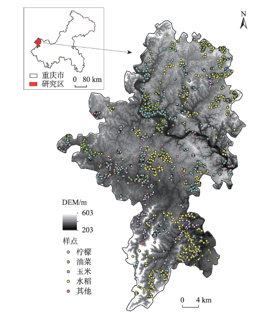
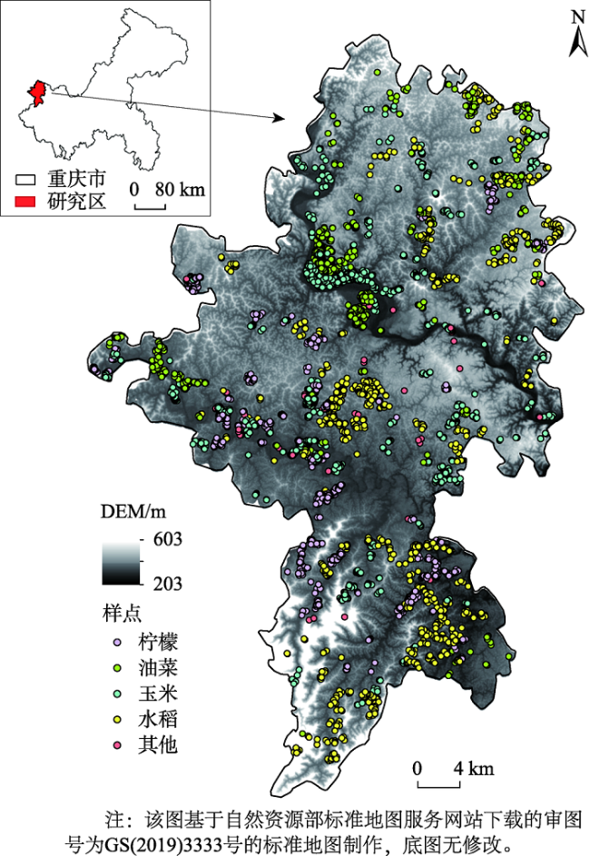
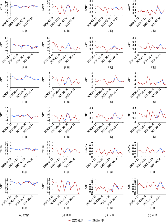
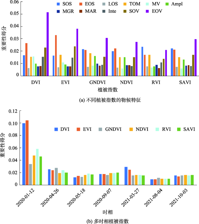
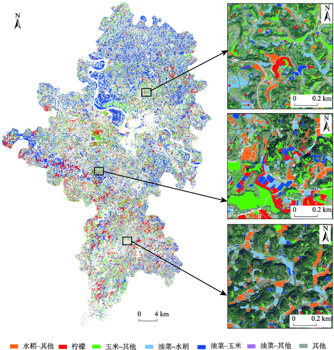
西南山区地块破碎且复杂,种植类型多样,且该地区多云多雨,可利用遥感数据有限,利用单一的光谱特征或植被指数难以实现作物的有效识别。物候特征能够反映作物的生长周期规律,可用于复杂地区作物的精细监测。本研究以重庆市潼南区为例,基于多时相中分辨率的Sentinel-2和Landsat8遥感影像,对地块尺度的NDVI、EVI等 6个植被指数进行时间序列构建并提取其物候特征,通过特征优选构建多维数据,利用随机森林分类模型对柠檬、油菜、水稻、玉米等作物进行识别。结合植被指数与物候特征进行作物分类,总体精度达94.52%,Kappa系数为0.90,柠檬、油菜、玉米、水稻的精度分别为89.88%、87.30%、84.98%和95.57%。研究表明,利用时序遥感数据的植被指数与物候特征能够有效进行地块尺度的作物识别,为复杂种植结构地区获取大范围作物分布制图提供参考。
秦肖伟 , 程博 , 杨志平 , 李林 , 董文 , 张新 , 杨树文 , 靳宗义 , 薛庆 . 基于时序遥感影像的西南山区地块尺度作物类型识别[J]. 地球信息科学学报, 2023 , 25(3) : 654 -668 . DOI: 10.12082/dqxxkx.2023.220522
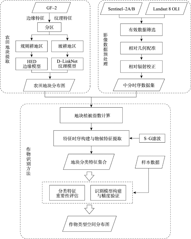
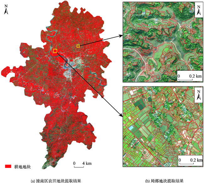
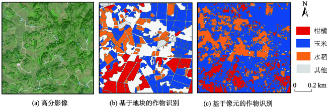
The distribution of crop planting structure can directly reflect the form and location of farmland, which is of great significance for the development of precision agriculture and inventory of agricultural resources. In the southwestern mountainous area in China, the farmland parcel is small and fragmented, with complex planting types, and thus the image visual characteristics are fuzzy and diverse. Due to the complexity of climate and terrain surface, it is difficult to identify crop types in this area. The arrival of the era of high-resolution remote sensing has promoted the rapid development of object-oriented crop extraction methods. Classification based on object segmentation combing spectral, contextual, and other features can effectively overcome the shortcomings of pixel-based classification methods and better serve the field farming management and land ownership management. Therefore, this study uses high-resolution remote sensing images to extract farmland parcels. Taking parcels as the spatial constraints, six time-series vegetation indices including NDVI, EVI, RVI, DVI, GNDVI, and SAVI, are constructed at the scale of parcels based on multi-temporal medium-resolution Sentinel-2 and Landsat8 OLI remote sensing images. Their phenological characteristics are also extracted using these remote sensing images. The multi-dimensional data are constructed through the importance evaluation of classification features, and the random forest classification model is used to identify crop types (i.e., lemon, rape, rice, corn, and other crops) combined with field sampling data. By comparing the classification accuracy using vegetation indices or phenological characteristics alone and that combining vegetation indices and phenological characteristics together, we found that the classification accuracy combining vegetation indices and phenological characteristics is the highest. The overall accuracy is 94.52%, and the Kappa coefficient is 0.90. The accuracy of lemon, rape, corn, rice, and others is 89.88%, 87.30%, 84.98%, 95.57%, and 98.05%, respectively. There are 90 348 lemon parcels, 30 173 rape parcels, 271 606 corn parcels, 146 113 rice parcels, and 16 406 other parcels, accounting for 10.96%, 36.40%, 32.94%, 17.72%, and 1.99% of the total farmland in Tongnan area, respectively. The planting area accounted for 14.82%, 18.44%, 35.37%, 29.92% and 1.45%, respectively. Our results indicate that the vegetation indices and phenological characteristics extracted from time-series remote sensing data can be used for crop identification at the parcel scale, which provides reference for obtaining large-scale crop mapping in the region with complex planting structures.
表1 植被指数Tab. 1 Vegetation indices |
| 简称 | 全称 | 计算公式 | 公式编号 | 文献 |
|---|---|---|---|---|
| NDVI | Normalized Difference Vegetation Index | (RNir-RRed)/(RNir+RRed) | (1) | [28] |
| EVI | Enhanced Vegetation Index | 2.5(RNir-RRed)/ (RNir+6.0RRed-7.5RBlue+1) | (2) | [29] |
| RVI | Ratio Vegetation Index | RNir/RRed | (3) | [30] |
| DVI | Difference Vegetation Index | RNir-RRed | (4) | [31] |
| GNDVI | Green Normalized Difference Vegetation Index | (RNir-RGreen)/(RNir+RGreen) | (5) | [32] |
| SAVI | Soil Adjusted Vegetation Index | (1+0.5)(RNir-RRed)/(RNir+RRed+0.5) | (6) | [33] |
注:RBlue、RGreen、RRed、RNir分别为Sentinel-2和Landsat8的蓝、绿、红和近红外波段反射率。 |
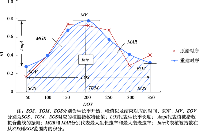
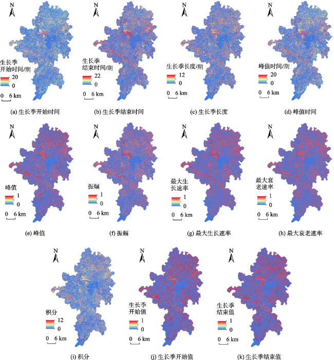
图2 基于重建植被指数时序曲线的物候特征提取示意Fig. 2 Schematic diagram of phenological characteristic extraction based on reconstructed temporal curve of Vegetation Index |
表2 物候特征生理学含义Tab. 2 Phenological characteristic physiological meaning |
| 简称 | 生理学含义 |
|---|---|
| SOS、SOV | 作物返青或出苗期,开始进行光合作用 |
| EOS、EOV | 作物衰老或收获期,光合作用减弱或终止 |
| TOM、MV | 作物生长鼎盛期,光合作用等生理活动最旺盛 |
| LOS | 作物的生长周期长度 |
| Ampl | 作物长势变化 |
| MGR | 作物生长发育速率 |
| MAR | 作物成熟衰老速率 |
| Inte | 衡量光合作用能力的总体强度 |
表3 实验数据详细信息Tab. 3 Details of experimental data |
| 序号 | 成像日期 | 整体云量/% | 卫星 |
|---|---|---|---|
| 1* | 2020-01-12 | 7.72 | Sentinel-2A |
| 2 | 2020-02-16 | 0.26 | Sentinel-2B |
| 3 | 2020-03-12 | 3.09 | Sentinel-2A |
| 4 | 2020-03-17 | 1.29 | Sentinel-2B |
| 5* | 2020-04-26 | 17.65 | Sentinel-2B |
| 6 | 2020-05-02 | 0.64 | Landsat8 |
| 7* | 2020-05-18 | 7.37 | Landsat8 |
| 8 | 2020-06-25 | 0.68 | Sentinel-2B |
| 9 | 2020-08-06 | 32.44 | Landsat8 |
| 10* | 2020-09-07 | 3.42 | Landsat8 |
| 11 | 2020-10-23 | 36.32 | Sentinel-2B |
| 12 | 2021-01-13 | 2.01 | Landsat8 |
| 13 | 2021-02-10 | 0.79 | Sentinel-2B |
| 14* | 2021-03-27 | 0 | Sentinel-2A |
| 15 | 2021-05-01 | 63.12 | Sentinel-2B |
| 16 | 2021-05-16 | 25.30 | Sentinel-2A |
| 17 | 2021-06-22 | 35.16 | Landsat8 |
| 18 | 2021-07-30 | 38.02 | Sentinel-2B |
| 19* | 2021-08-04 | 0.12 | Sentinel-2A |
| 20 | 2021-08-24 | 11.44 | Sentinel-2A |
| 21 | 2021-09-26 | 36.31 | Landsat8 |
| 22* | 2021-10-03 | 2.61 | Sentinel-2A |
注:序号中*代表参与分类的时相数据。 |
表4 潼南区作物生长发育进程Tab. 4 Crop growth and development process in Tongnan district |
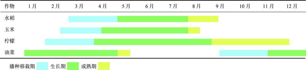 |
表5 不同分类特征与制图单元分类精度对比Tab. 5 Comparison of classification accuracy between different classification features and mapping units(%) |
| 分类特征 | 植被指数 | 物候特征 | 植被指数+物候特征 | |||||||
|---|---|---|---|---|---|---|---|---|---|---|
| 地块 | 像元 | 地块 | 像元 | 地块 | 像元 | |||||
| OA | 93.44 | 91.88 | 93.76 | 88.88 | 94.52 | 92.10 | ||||
| Kappa | 0.89 | 0.86 | 0.89 | 0.81 | 0.90 | 0.86 | ||||
| 柠檬 | 86.71 | 85.42 | 87.66 | 79.10 | 89.88 | 86.74 | ||||
| 油菜 | 85.18 | 83.99 | 87.29 | 77.52 | 87.30 | 82.98 | ||||
| 玉米 | 82.16 | 78.15 | 80.38 | 72.20 | 84.98 | 79.53 | ||||
| 水稻 | 95.85 | 93.84 | 92.44 | 91.70 | 95.57 | 93.64 | ||||
| 其他 | 97.75 | 96.56 | 98.11 | 95.43 | 98.05 | 96.55 | ||||
| [1] |
陈仲新, 任建强, 唐华俊, 等. 农业遥感研究应用进展与展望[J]. 遥感学报, 2016, 20(5):748-767.
[
|
| [2] |
刘哲, 刘帝佑, 朱德海, 等. 作物遥感精细识别与自动制图研究进展与展望[J]. 农业机械学报, 2018, 49(12):1-12.
[
|
| [3] |
张喜旺, 刘剑锋, 秦奋, 等. 作物类型遥感识别研究进展[J]. 中国农学通报, 2014, 30(33):278-285.
[
|
| [4] |
|
| [5] |
史舟, 梁宗正, 杨媛媛, 等. 农业遥感研究现状与展望[J]. 农业机械学报, 2015, 46(2):247-260.
[
|
| [6] |
张荣群, 王盛安, 高万林, 等. 基于时序植被指数的县域作物遥感分类方法研究[J]. 农业机械学报, 2015, 46(S1):246-252.
[
|
| [7] |
|
| [8] |
屠星月, 赵冬玲. 多时相遥感影像农作物识别方法的分析[J]. 测绘通报, 2012(S1):380-383.
[
|
| [9] |
雷光斌, 李爱农, 边金虎, 等. 基于阈值法的山区森林常绿、落叶特征遥感自动识别方法——以贡嘎山地区为例[J]. 生态学报, 2014, 34(24):7210-7221.
[
|
| [10] |
|
| [11] |
|
| [12] |
|
| [13] |
|
| [14] |
|
| [15] |
|
| [16] |
|
| [17] |
杜保佳, 张晶, 王宗明, 等. 应用Sentinel-2A NDVI时间序列和面向对象决策树方法的农作物分类[J]. 地球信息科学学报, 2019, 21(5):740-751.
[
|
| [18] |
宋茜, 胡琼, 陆苗, 等. 农作物空间分布遥感制图发展方向探讨[J]. 中国农业资源与区划, 2020, 41(6):57-65.
[
|
| [19] |
|
| [20] |
杨颖频, 吴志峰, 骆剑承, 等. 时空协同的地块尺度作物分布遥感提取[J]. 农业工程学报, 2021, 37(7):166-174.
[
|
| [21] |
邓刘洋, 沈占锋, 柯映明, 等. 基于地块尺度多时相遥感影像的冬小麦种植面积提取[J]. 农业工程学报, 2018, 34(21):157-164.
[
|
| [22] |
|
| [23] |
朱长明, 骆剑承, 沈占锋, 等. 基于地块特征基元与多时相遥感数据的冬小麦播种面积快速提取[J]. 农业工程学报, 2011, 27(9):94-99.
[
|
| [24] |
|
| [25] |
刘巍, 吴志峰, 骆剑承, 等. 深度学习支持下的丘陵山区耕地高分辨率遥感信息分区分层提取方法[J]. 测绘学报, 2021, 50(1):105-116.
[
|
| [26] |
吴志峰, 骆剑承, 孙营伟, 等. 时空协同的精准农业遥感研究[J]. 地球信息科学学报, 2020, 22(4):731-742.
[
|
| [27] |
施海霞, 韦玉春, 徐晗泽宇, 等. 高分遥感图像相对辐射校正中的伪不变地物自动提取和优化选择[J]. 地球信息科学学报, 2021, 23(5):903-917.
[
|
| [28] |
|
| [29] |
|
| [30] |
|
| [31] |
|
| [32] |
|
| [33] |
|
| [34] |
屈炀, 袁占良, 赵文智, 等. 基于多时序特征和卷积神经网络的农作物分类[J]. 遥感技术与应用, 2021, 36(2):304-313.
[
|
| [35] |
张锦水, 赵光政, 洪友堂, 等. 基于像元物候曲线匹配的生长季内河北省冬小麦空间分布识别[J]. 农业工程学报, 2020, 36(23):193-200.
[
|
| [36] |
边金虎, 李爱农, 宋孟强, 等. MODIS植被指数时间序列Savitzky-Golay滤波算法重构[J]. 遥感学报, 2010, 14(4):725-741.
[
|
| [37] |
|
| [38] |
| [39] |
雷震. 随机森林及其在遥感影像处理中应用研究[D]. 上海: 上海交通大学, 2012.
[
|
| [40] |
方匡南, 吴见彬, 朱建平, 等. 随机森林方法研究综述[J]. 统计与信息论坛, 2011, 26(3):32-38.
[
|
| [41] |
刘毅, 杜培军, 郑辉, 等. 基于随机森林的国产小卫星遥感影像分类研究[J]. 测绘科学, 2012, 37(4):194-196.
[
|
| [42] |
张鹏, 胡守庚. 地块尺度的复杂种植区作物遥感精细分类[J]. 农业工程学报, 2019, 35(20):125-134.
[
|
| [43] |
贾坤, 李强子. 农作物遥感分类特征变量选择研究现状与展望[J]. 资源科学, 2013, 35(12):2507-2516.
[
|
/
| 〈 |
|
〉 |