
人口空间化适宜格网评价方法研究
|
罗永臻(1998— ),男,青海西宁人,硕士生,主要从事自然资源与国土空间分析研究。E-mail: 860528781@qq.com |
收稿日期: 2022-07-21
修回日期: 2022-10-13
网络出版日期: 2023-04-27
基金资助
国家自然科学基金面上项目(71773117)
国家自然科学基金面上项目(71903183)
国家社会科学基金重大项目(18ZDA066)
院基本业务费项目(AR2207)
Study on the Method of Evaluating the Suitable Grid for Population Spatialization
Received date: 2022-07-21
Revised date: 2022-10-13
Online published: 2023-04-27
Supported by
National Natural Science Foundation of China(71773117)
National Natural Science Foundation of China(71903183)
Major Projects of the National Social Science Foundation of China(18ZDA066)
Basic operating expenses of the institution(AR2207)
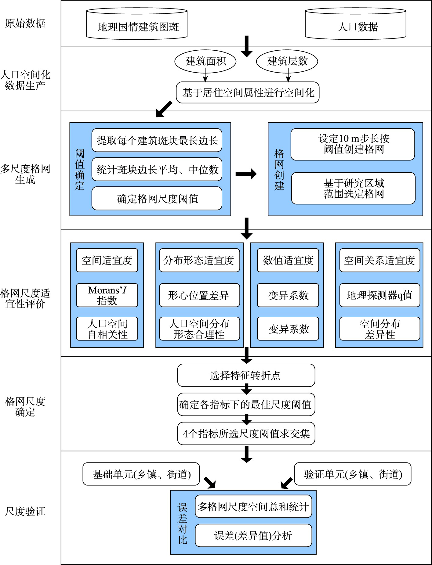
人口在空间上分布的差异较大,统一的格网尺度只能按照一种格网尺度体现人口空间分布,对不同区域更密集或更稀疏人口的空间化表达较差,为了更精准地表达人口空间分布,本文提出一种依据多指标分析的适宜格网尺度确定方法,构建以形心差异距离为创新的指标体系,结合空间适宜度、数值适宜度和空间关系适宜度,利用空间自相关、变异系数与地理探测器模型从空间和数值的角度上摆脱了景观指数自身存在的尺度效应问题。根据各指标特征点变化分析确定各指标下适宜格网尺度阈值,然后采用相对误差绝对值的验证方法,计算与真实人口数值的相对误差绝对值的几何平均值来验证指标分析结果,确定人口格网较适宜尺度。本文将首都经济圈唐山市古冶区作为实证分析区,根据指标体系分析的实验结果表明:随着格网尺度的增大,人口斑块集聚聚类间的差异逐渐变小,其分布形态表现性变差,且人口格网的总体表现能力随尺度增大逐渐降低;从空间适宜度、分布形态适宜度、数值适宜度和空间关系适宜度4个角度进行特征点变化分析,确定90 m、100 m为较适宜格网尺度,在该尺度下进行人口空间化可以得到质量较好的数据结果。通过验证分析可知,该研究区下的人口空间化较适宜格网尺度确定方法存在一定的科学性及合理性。

罗永臻 , 董春 , 张玉 . 人口空间化适宜格网评价方法研究[J]. 地球信息科学学报, 2023 , 25(5) : 896 -908 . DOI: 10.12082/dqxxkx.2023.220536
The spatial distribution of world population varies considerably from region to region due to differences in geography and economic development, which requires a specific scale of population grid for population spatialization in different regions. A uniform grid scale can only represent the spatial distribution of population at one grid scale, which leads to poor representation for more densely or sparsely populated areas. In order to express the spatial distribution of the population more accurately and determine the appropriate scale of the population grid for a given area, this paper proposes a method to determine the scale of suitable grids based on a multi-indicator analysis. We construct an innovative index system based on the shape-centered difference distance, by combining spatial suitability, numerical suitability, and spatial relationship suitability, and use spatial autocorrelation, coefficient of variation, and geographic detector model to get rid of the scale effect of landscape index from the spatial and numerical perspectives. In this paper, the process of population spatialization employs geographic country data combined with occupancy spatial attributes (i.e., number of building floors and floor area). The suitable scale threshold of the grid under each index is determined based on the analysis of the change of the characteristic points of each index, and then the common scale threshold is identified as the overall suitable grid scale. The geometric mean of the absolute relative error against the real population value is calculated to verify the index analysis results and the suitable scale of population grid. This paper takes the Guye District of Tangshan city in the Capital Economic Circle as the empirical analysis area. The results of the index system analysis show that the differences between clusters of population patches gradually become smaller and their distribution patterns become less expressive as the scale of the girds increases, and the overall expressiveness of the population grid gradually decreases as the scale increases. From perspectives of spatial suitability, distribution morphology suitability, numerical suitability, and spatial relationship suitability, 90 m and 100 m are identified as the suitable grid scales, under which the population spatialization could obtain better quality. The validation analysis demonstrates that the method of determining suitable grid scale for population spatialization in this study has a certain degree of validity and reliability.

| [1] |
董春, 刘纪平, 赵荣, 等. 地理因子与空间人口分布的相关性研究[J]. 遥感信息, 2002, 17(4):61-64.
[
|
| [2] |
柏中强, 王卷乐, 杨飞. 人口数据空间化研究综述[J]. 地理科学进展, 2013, 32(11):1692-1702.
[
|
| [3] |
|
| [4] |
董南, 杨小唤, 蔡红艳. 人口数据空间化研究进展[J]. 地球信息科学学报, 2016, 18(10):1295-1304.
[
|
| [5] |
董春, 尹诗画, 张玉. 多智能体的城市精细尺度人口估算模型[J]. 测绘科学, 2019, 44(8):113-119.
[
|
| [6] |
李泽宇, 董春. 引入兴趣点的地理加权人口空间分布模型研究——以天津市为例[J]. 遥感信息, 2019, 34(2):113-117.
[
|
| [7] |
廖顺宝, 孙九林. 基于GIS的青藏高原人口统计数据空间化[J]. 地理学报, 2003, 58(1):25-33.
[
|
| [8] |
杨晓荣, 陈楠. 基于多源数据的福建省人口数据空间化研究[J]. 贵州大学学报(自然科学版), 2019, 36(2):79-84,95.
[
|
| [9] |
|
| [10] |
江东, 王乃斌, 刘红辉. 人口数据空间化的处理方法[J]. 地理学报, 2002(B12):70-75.
[
|
| [11] |
|
| [12] |
|
| [13] |
|
| [14] |
高占慧. 区域生态环境评价中的统计数据空间化方法研究——以山东省为例[D]. 济南: 山东师范大学, 2012.
|
| [15] |
|
| [16] |
叶靖, 杨小唤, 江东. 乡镇级人口统计数据空间化的格网尺度效应分析——以义乌市为例[J]. 地球信息科学学报, 2010, 12(1):40-47.
[
|
| [17] |
杜国明, 张树文, 张有全. 城市人口分布的空间自相关分析——以沈阳市为例[J]. 地理研究, 2007, 26(2):383-390.
[
|
| [18] |
李月娇, 杨小唤, 王静. 基于景观生态学的人口空间数据适宜格网尺度研究——以山东省为例[J]. 地理与地理信息科学, 2014, 30(1):97-100.
[
|
| [19] |
|
| [20] |
刘学录. 我国景观生态学尺度效应研究进展[J]. 甘肃农业大学学报, 2021, 56(6):1-9.
[
|
| [21] |
|
| [22] |
王培震, 石培基, 魏伟, 等. 基于空间自相关特征的人口密度格网尺度效应与空间化研究——以石羊河流域为例[J]. 地球科学进展, 2012, 27(12):1363-1372.
[
|
| [23] |
郑鹏, 陈伟, 顾媛媛, 等. 基于Voronoi图的多航行器不规则区域搜索规划方法研究[C]// 第四届水下无人系统技术高峰论坛:有人/无人协同技术论文集.陕西,中国: 2021:92-97.
[
|
| [24] |
张国俊, 黄婉玲, 周春山, 等. 城市群视角下中国人口分布演变特征[J]. 地理学报, 2018, 73(8):1513-1525.
[
|
| [25] |
刘妙龙, 陈鹏, 冯永玖. 上海市人口分形的时空演化与区域差异研究[J]. 中国人口科学, 2005(2):51-60,96.
[
|
| [26] |
王劲峰, 徐成东. 地理探测器:原理与展望[J]. 地理学报, 2017, 72(1):116-134.
[
|
| [27] |
杨瑞红, 董春, 张玉. 地理国情普查数据支持下的人口空间化方法[J]. 测绘科学, 2017, 42(1):76-81.
[
|
| [28] |
|
/
| 〈 |
|
〉 |