
地理知识图谱下的建筑群空间分布模式推理
|
唐曾杨(1997— ),男,湖北恩施人,硕士,主要从事地理知识图谱,地图综合研究。E-mail: tangzengyang@whu.edu.cn |
收稿日期: 2022-10-08
修回日期: 2022-12-07
网络出版日期: 2023-06-02
基金资助
国家自然科学基金项目(42071450)
Reasoning of Spatial Distribution Pattern of Building Cluster based on Geographic Knowledge Graph
Received date: 2022-10-08
Revised date: 2022-12-07
Online published: 2023-06-02
Supported by
National Natural Science Foundation of China(42071450)
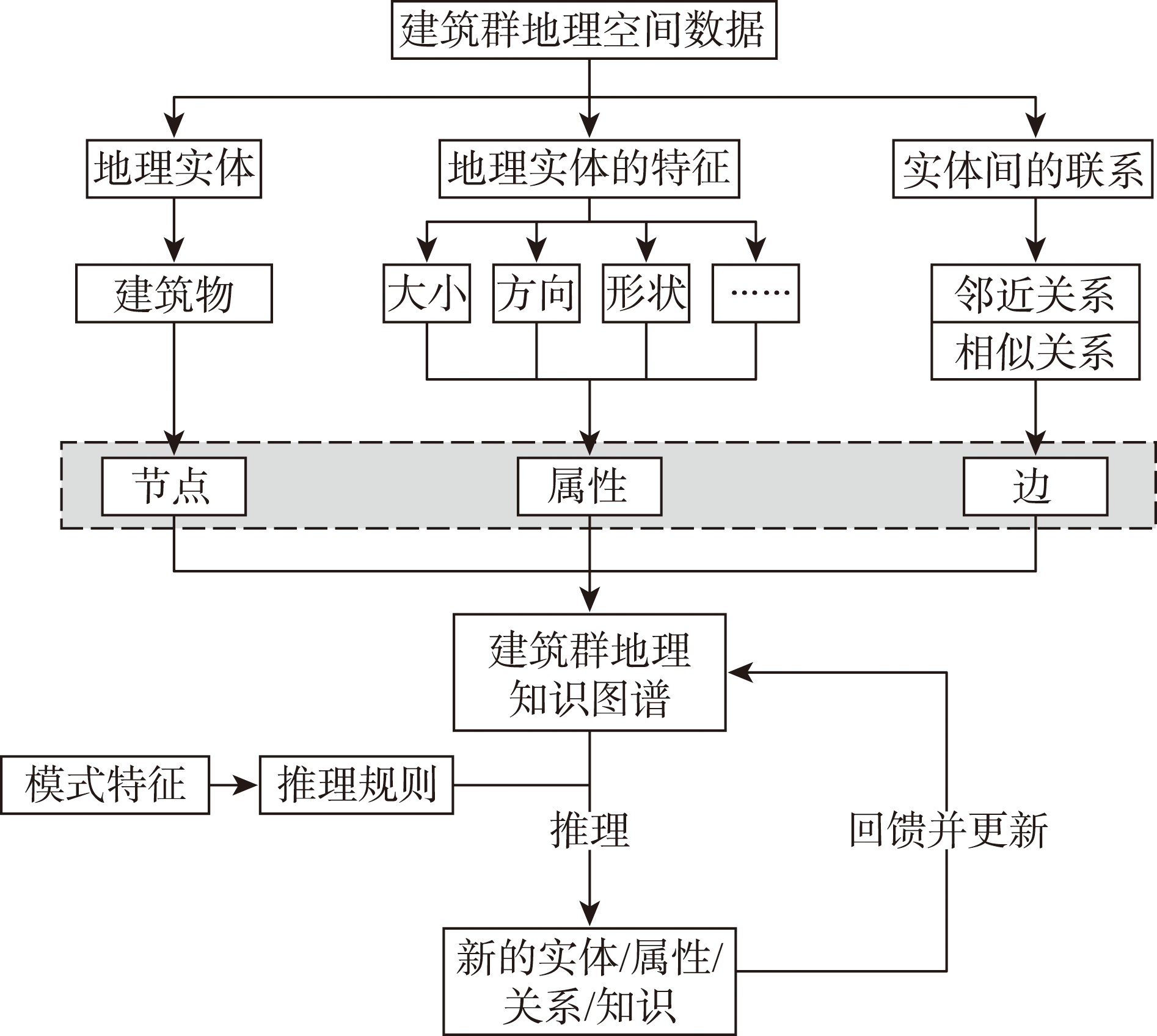
以图结构表达的知识图谱不仅在语义网络的描述与推理中发挥着重要作用,对于空间实体的结构化抽象与空间推理也具有重要意义。空间实体的联系信息在知识图谱中以图的边记录,通过路径探测、子图对齐、模式发现等基于边的知识图谱计算推理,在空间场景认知可发挥重要作用。地理知识图谱是一种对地理概念、实体及其相互关系进行形式化描述的知识系统,既有通用知识的内涵与特点,也有地理知识特定的时空特征,能够将语义模型和时空模型联系起来,描述语义关系、空间关系和时间关系,在地理知识的表达、理解、获取与推理方面有巨大的应用潜力。现有地理知识图谱的研究工作多集中于语义方面,语义关系的抽取与表达比较丰富,可以支持进一步的地理知识语义搜索等功能;然而地理知识图谱在时空模型上的知识表达比较缺乏,现有的空间关系局限在要素之间,很少涉及空间认知中进一步的分布态势、空间格局等,地理知识图谱在空间语义知识方面有待增强。本文基于知识图谱构建原理,以建筑群地理知识图谱构建为例,实现格网型建筑物模式的识别。先将建筑物抽象成实体,表达为图的节点,基于几何邻近分析提取建筑物之间的空间邻域关系,以此构建建筑群地理知识图谱;在此基础上结合建筑物模式识别的领域知识,进一步推理构建其他的空间语义关系,完善地理知识图谱;再将建筑群场景的格网模式表达为知识图谱的规则,在知识图谱上基于NoSQL语言进行推理。结果表明,本文方法能有效提取建筑物格网模式,验证了地理知识图谱在空间推理上的作用和在领域问题研究中的良好适应性,为地理知识图谱在空间认知领域的应用提供了思路。
唐曾杨 , 艾廷华 , 徐海江 . 地理知识图谱下的建筑群空间分布模式推理[J]. 地球信息科学学报, 2023 , 25(6) : 1202 -1214 . DOI: 10.12082/dqxxkx.2023.220761
The graph structure-based knowledge graph plays important roles not only in the description and reasoning of semantic network, but also in the structured abstraction and spatial reasoning of spatial entities. The relational information of spatial entities is recorded in edges in the knowledge graph. Through the edge-based knowledge graph computational reasoning such as path detection, sub graph alignment, pattern discovery, etc., it can play an important role in spatial scene cognition. Geographic knowledge graph is a knowledge system that formally describes geographic concepts, entities, and their interrelationships. It has both the connotation and characteristics of general knowledge and the specific spatiotemporal characteristics of geographic knowledge. It can connect semantic models with spatiotemporal models to describe semantic relations, spatial relations, and temporal relations, and has great application potential in the expression, understanding, acquisition, and reasoning of geographic knowledge. The existing research work of geographic knowledge graph is mostly focused on semantics, and the extraction and expression of semantic relations are very rich and comprehensive, which can support further functions such as semantic search and association analysis of geographic knowledge. However, the knowledge expression of geographic knowledge graph in spatiotemporal model is relatively lacking, and the existing spatial relationship is limited between elements, rarely involving the further distribution situation and spatial pattern in spatial cognition. Thus, the geographic knowledge graph needs to be strengthened in terms of spatial semantic knowledge. Based on the principle of knowledge graph construction, this paper takes the construction of geographic knowledge graph of buildings as an example to realize the grid-pattern recognition of buildings. Firstly, the buildings are abstracted into entities and expressed as nodes of the graph, and the spatial neighborhood relations between buildings is extracted based on geometric proximity analysis, so as to build the geographic knowledge graph of the building group. On this basis, combined with the domain knowledge of building pattern recognition, it further infers and constructs other spatial semantic relations, and improves the geographic knowledge graph. Then the grid-pattern of the buildings complex scene is expressed as the rules of the knowledge graph, which is based on NoSQL language for reasoning. The results show that this method can effectively extract the linear pattern of buildings and further deduce the grid-pattern, which demonstrates the important role of geographic knowledge graph in spatial reasoning and its good adaptability in domain problem research, and provides ideas for the application of geographic knowledge graph in the field of spatial cognition.
表1 空间关系与语义关系Tab. 1 Spatial relation and semantic relation |
| 地理知识图谱中的关系分类 | 关系示例 |
|---|---|
| 空间关系 | Intersects,Disjoint,Contains,Within,……, over-,up-,in-,out-,…… |
| 语义关系 | 河流的汇入关系,资产的权属关系, 管理结构的层级关系,人的社会关系,…… |
表2 知识图谱中的表达要素Tab. 2 Expression elements in knowledge graph |
| 类型 | 要素 | 属性/描述 |
|---|---|---|
| 实体 | 建筑物(single) | 形状、面积、方向等 |
| 标签 | 直线模式(linearPattern) | lineList:建筑物ID列表 relaList:关系ID列表 |
| 格网模式(gridPattern) | ||
| 关系 | 邻近关系(nextTo) | 两建筑物邻近 |
| 相似关系(similarTo) | 两建筑物相似 | |
| 协同格网关系(gridWith) | 两直线模式协同构成格网模式 |
表3 相似关系定义Tab. 3 The definition of similarity relationship |
| 参量 | 指标描述 | 计算方式 |
|---|---|---|
| 建筑物的延展度接近程度 | 两建筑物延展度差值的绝对值,延展度:最小外接矩形的长宽比 | |
| 建筑物的大小接近程度 | 两建筑物中较大面积值除以较小面积值 | |
| 建筑物的最小外接矩形长边方向(Smallest bounding rectangle orientation)之间的接近程度 | 两建筑物最小外接矩形长边方向的差值 |
表4 直线模式和格网模式的推理规则要素Tab. 4 The reasoning rules of linear pattern and grid pattern |
| 推理规则要素 | 描述 |
|---|---|
| shapeSimi(x,y) | x,y形状相似 |
| areaSimi(x,y) | x,y大小相似 |
| directionSimi_B(x,y) | x,y建筑物方向相似 |
| similar(x,y) | x,y相似 |
| near(x,y) | x,y邻近 |
| interval(x,y,z) | x,y,z近似等距分布 |
| sameLine(x,y,z) | x,y,z在一条直线上 |
| tmpThree(x,y,z) | x,y,z组成三元直线模式 |
| linerPattern(A) | A中元素构成直线模式 |
| directionSimi_Lp(A,B) | A,B直线方向相似 |
| close(A,B) | A,B中大部分元素具有邻近关系 |
| gridPattern(A,B) | A,B协同形成格网模式 |
表5 模式识别结果统计Tab. 5 Statistics of pattern recognition results |
| 模式 | |||||||
|---|---|---|---|---|---|---|---|
| linearPattern | 456 | 446 | 398 | 48 | 58 | 89.2% | 87.3% |
| gridPattern | 180 | 172 | 148 | 24 | 32 | 86.0% | 82.2% |
| [1] |
|
| [2] |
王飞, 陈立, 易绵竹, 等. 新技术驱动的自然语言处理进展[J]. 武汉大学学报(工学版), 2018, 51(8):669-678.
[
|
| [3] |
秦川, 祝恒书, 庄福振, 等. 基于知识图谱的推荐系统研究综述[J]. 中国科学:信息科学, 2020, 50(7):937-956.
[
|
| [4] |
漆桂林, 高桓, 吴天星. 知识图谱研究进展[J]. 情报工程, 2017, 3(1):4-25.
[
|
| [5] |
刘峤, 李杨, 段宏, 等. 知识图谱构建技术综述[J]. 计算机研究与发展, 2016, 53(3):582-600.
[
|
| [6] |
|
| [7] |
陆锋, 余丽, 仇培元. 论地理知识图谱[J]. 地球信息科学学报, 2017, 19(6):723-734.
[
|
| [8] |
张春菊, 张雪英, 朱少楠, 等. 基于网络爬虫的地名数据库维护方法[J]. 地球信息科学学报, 2011, 13(4):492-499.
[
|
| [9] |
|
| [10] |
|
| [11] |
蒋秉川, 万刚, 许剑, 等. 多源异构数据的大规模地理知识图谱构建[J]. 测绘学报, 2018, 47(8):1051-1061.
[
|
| [12] |
刘俊楠, 刘海砚, 陈晓慧, 等. 面向多源地理空间数据的知识图谱构建[J]. 地球信息科学学报, 2020, 22(7):1476-1486.
[
|
| [13] |
张雪英, 张春菊, 吴明光, 等. 顾及时空特征的地理知识图谱构建方法[J]. 中国科学:信息科学, 2020, 50(7):1019-1032.
[
|
| [14] |
段鹏飞, 王远, 熊盛武, 等. 基于空间投影和关系路径的地理知识图谱表示学习[J]. 中文信息学报, 2018, 32(3):26-33.
[
|
| [15] |
陈军, 刘万增, 武昊, 等. 基础地理知识服务的基本问题与研究方向[J]. 武汉大学学报·信息科学版, 2019, 44(1):38-47.
[
|
| [16] |
|
| [17] |
|
| [18] |
林珲, 游兰, 胡传博, 等. 时空大数据时代的地理知识工程展望[J]. 武汉大学学报·信息科学版, 2018, 43(12):2205-2211.
[
|
| [19] |
|
| [20] |
艾廷华, 郭仁忠. 基于格式塔识别原则挖掘空间分布模式[J]. 测绘学报, 2007, 36(3):302-308.
[
|
| [21] |
|
| [22] |
|
| [23] |
程博艳, 刘强, 李小文. 一种建筑物群智能聚类法[J]. 测绘学报, 2013, 42(2):290-294,303.
[
|
| [24] |
王米琪, 艾廷华, 晏雄锋, 等. 图卷积网络模型识别道路正交网格模式[J]. 武汉大学学报·信息科学版, 2020, 45(12):1960-1969.
[
|
| [25] |
蒋逸, 张伟, 王佩, 等. 基于互联网群体智能的知识图谱构造方法[J]. 软件学报, 2022, 33(7):2646-2666.
[
|
| [26] |
|
| [27] |
|
| [28] |
|
/
| 〈 |
|
〉 |


