
全息地球数据立方体模型研究
|
罗 斌(1982— ),男,硕士,湖南邵阳人,主要从事全息地图与数字地球平台技术研究。E-mail: luob@igsnrr.ac.cn |
收稿日期: 2023-03-03
修回日期: 2023-04-27
网络出版日期: 2023-06-30
基金资助
国家重点研发计划项目(2018YFE0204203)
Research on the Digital Holographic Earth Data Cube Model
Received date: 2023-03-03
Revised date: 2023-04-27
Online published: 2023-06-30
Supported by
National Key Research and Development Program of China(2018YFE0204203)
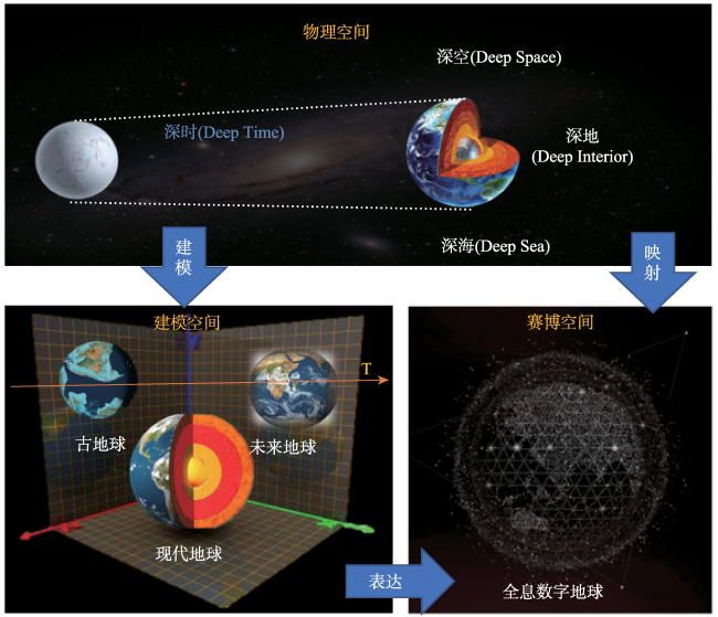
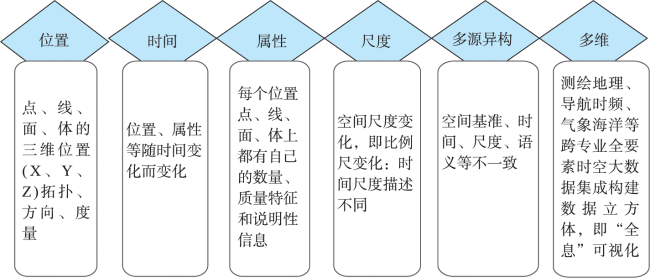
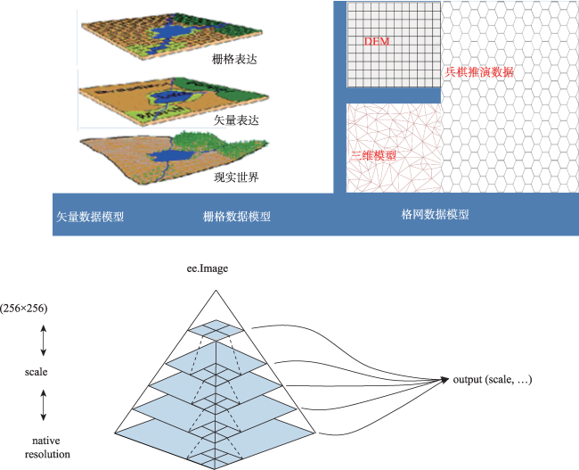
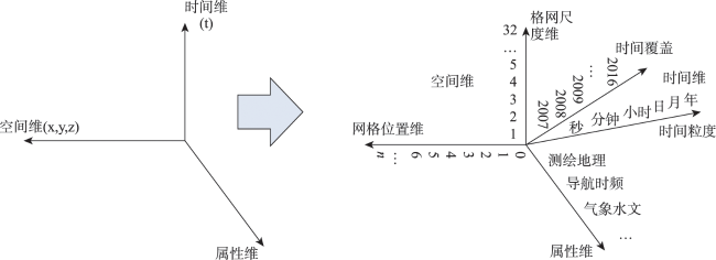
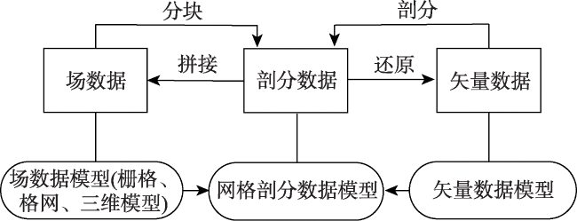
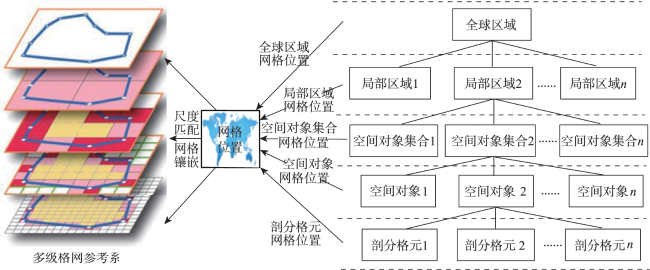
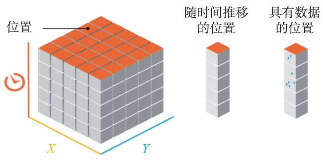
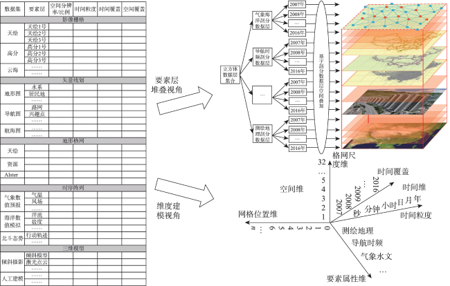
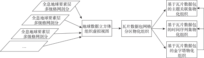
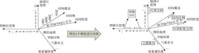
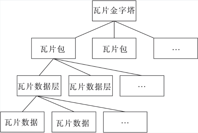
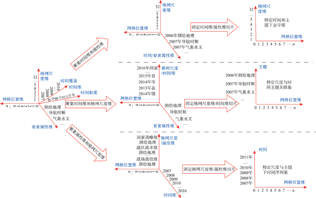
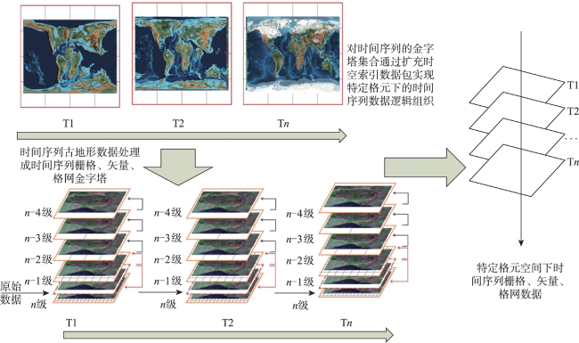
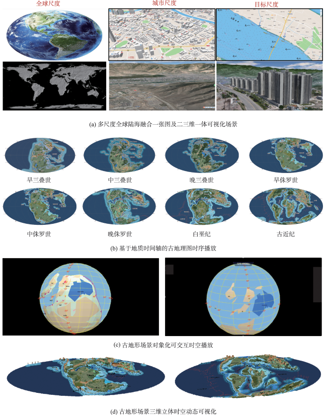
进入地球大数据与地球人工智能时代,数字地球建模要求也从地表扩展到全域全时全息,而当前数字地球的数据模型还基本停留在瓦片或地球网格剖分数据模型阶段,严重制约了场景化、智能化数字地球应用。本文提出了全息地球概念以及相应的地球数据立方体组织模型,采用全球多级格网参考系统来描述和表达多尺度空间,用平面或立体格元来表达空间位置,将传统“经度、纬度、高程、时间”时空表达发展至“时间粒度、时间覆盖、网格位置、格网尺度”新时空表达体系,并设计了按照“时间—空间—尺度—属性”一致性描述的全息地球数据建模方案,将矢量、栅格、格网、时序阵列、三维模型等多模态数据归纳至一个统一模型中,使得任何引用特定地球数据立方体中的数据值在时间、空间、尺度都是对齐的,解决了全息地球跨专业、多维时空动态场景数据时空融合集成难题,并结合深时数字地球国际大科学计划全球数字化科研平台需求,开发了深时古地形时空动态可视化模拟系统,完成对模型的验证。

罗斌 , 任丽秋 , 毛悦 , 史瑞鹏 , 诸云强 , 吴超伟 . 全息地球数据立方体模型研究[J]. 地球信息科学学报, 2023 , 25(7) : 1282 -1296 . DOI: 10.12082/dqxxkx.2023.230105
With the development of big data and artificial intelligence, the scope of digital earth modeling has extended to full-time holography beyond the earth surface. However, the current data model of digital earth still remains in the data modelling of earth tile or grid subdivision. This model severely limits the application of scenario-based and intelligent digital earth development. This paper proposes the concept of digital holographic earth and a corresponding data organization model of earth data cube. By using global multi-level grid reference system to describe and express multi-scale space and using two or three-dimensional grid cells to describe spatial positions, the traditional spatiotemporal description of "longitude, latitude, elevation, and time" is transformed to a new spatiotemporal description system of "time granularity, time coverage, grid position, and grid scale". The proposed model is characterized by the dimensions of "time-space-scale-attribute" based on spatiotemporal big data in the digital earth. The model encapsulates vectors, rasters, grids, time series arrays, and 3D models into an unified system. This unified system ensures that any data value of a specific earth data cube is aligned perfectly in time, space, and scale, which solves the problem of multi-dimensional or spatiotemporal dynamic fusion of big earth data. Finally, this paper develops a deep-time and spatiotemporal dynamic visualization simulation system to verify the data model based on the requirements of the Deep-time Digital Earth International Science Program.
Key words: digital earth; mesh division; data cube; spatiotemporal scene; hologram; Deep-time Digital Earth; DDE
| [1] |
承继成, 郭华东, 薛勇. 数字地球导论[M]. 2版. 北京: 科学出版社, 2007.
[
|
| [2] |
李德仁, 龚健雅, 邵振峰. 从数字地球到智慧地球[J]. 武汉大学学报·信息科学版, 2010, 35(2):127-132,253.
[
|
| [3] |
郭华东, 王力哲, 陈方, 等. 科学大数据与数字地球[J]. 科学通报, 2014, 59(12):1047-1054.
[
|
| [4] |
|
| [5] |
诸云强. 地球系统科学数据共享关键技术研究[M]. 北京: 科学出版社, 2009.
[
|
| [6] |
马自坤, 黄体杨. 情报学研究中的全息论[J]. 情报科学, 2009, 27(9):1301-1304,1310.
[
|
| [7] |
王家耀, 武芳, 郭建忠, 成毅, 陈科. 测绘科学[J]. 时空大数据面临的挑战与机遇, 2017, 42(7):1-7.
[
|
| [8] |
周成虎, 朱欣焰, 王蒙, 等. 全息位置地图研究[J]. 地理科学进展, 2011, 30(11):1331-1335.
[
|
| [9] |
周成虎, 欧阳, 马廷. 地理格网模型研究进展[J]. 地理科学进展, 2009, 28(5):657-662.
[
|
| [10] |
李德仁, 朱欣焰, 龚健雅. 从数字地图到空间信息网格——空间信息多级网格理论思考[J]. 武汉大学学报·信息科学版, 2003, 28(6):642-650.
[
|
| [11] |
程承旗, 任伏虎, 濮国梁. 空间信息剖分组织导论[M]. 北京: 科学出版社, 2012.
[
|
| [12] |
童晓冲. 空间信息剖分组织的全球离散格网理论与方法[J]. 测绘学报, 2011, 40(4):536.
[
|
| [13] |
李德仁, 肖志峰, 朱欣焰, 等. 空间信息多级网格的划分方法及编码研究[J]. 测绘学报, 2006, 35(1):52-56,70.
[
|
| [14] |
马晓霞. 地理格网参照下的空间数据集成方法研究[D]. 西安: 长安大学.
[
|
| [15] |
|
| [16] |
|
| [17] |
|
| [18] |
|
| [19] |
|
| [20] |
|
| [21] |
|
| [22] |
邹逸江. 多维空间分析的关键技术——空间数据立方体[J]. 地理与地理信息科学, 2006, 22(1):12-16.
[
|
| [23] |
邹逸江, 李德仁, 王任享. 空间数据立方体分析操作原理[J]. 武汉大学学报·信息科学版, 2004, 29(9):822-826.
[
|
| [24] |
赵春宇. 高性能并行GIS中矢量空间数据存取与处理关键技术研究[D]. 武汉: 武汉大学.
[
|
| [25] |
|
| [26] |
|
| [27] |
|
| [28] |
|
| [29] |
|
| [30] |
|
| [31] |
|
| [32] |
|
| [33] |
张威. 多源空间数据集成方法研究[D]. 郑州: 解放军信息工程大学.
[
|
| [34] |
贾文珏, 安琼. 基于“分治网格”的空间大数据快速分析方法[J]. 计算机工程与设计, 2015, 36(8):2317-2321.
[
|
| [35] |
程承旗, 张恩东, 万元嵬, 等. 遥感影像剖分金字塔研究[J]. 地理与地理信息科学, 2010, 26(1):19-23.
[
|
| [36] |
|
/
| 〈 |
|
〉 |
