
不同街景影像微环境提取方法对街面财产犯罪解释的差异分析
|
柳 林(1965— ),男,湖南湘潭人,博士,教授,博导,主要从事犯罪地理及地理信息科学研究。E-mail: lin.liu@uc.edu |
收稿日期: 2022-11-24
修回日期: 2023-02-24
网络出版日期: 2023-06-30
基金资助
广州市科技计划项目(202201010288)
国家自然科学基金项目(42201257)
测绘遥感信息工程国家重点实验室资助课题(21I02)
A Comparative Study of Different Street View Image Micro-environment Extraction Methods for Explaining Street Property Crimes
Received date: 2022-11-24
Revised date: 2023-02-24
Online published: 2023-06-30
Supported by
Science and Technology Projects in Guangzhou(202201010288)
National Natural Science Foundation of China(42201257)
Open Fund of State Laboratory of Information Engineering in Surveying, Mapping and Remote Sensing, Wuhan University(21I02)
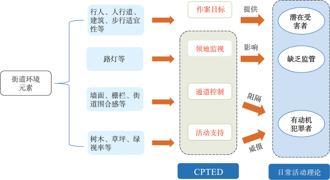
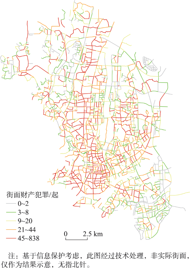
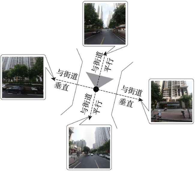
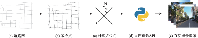
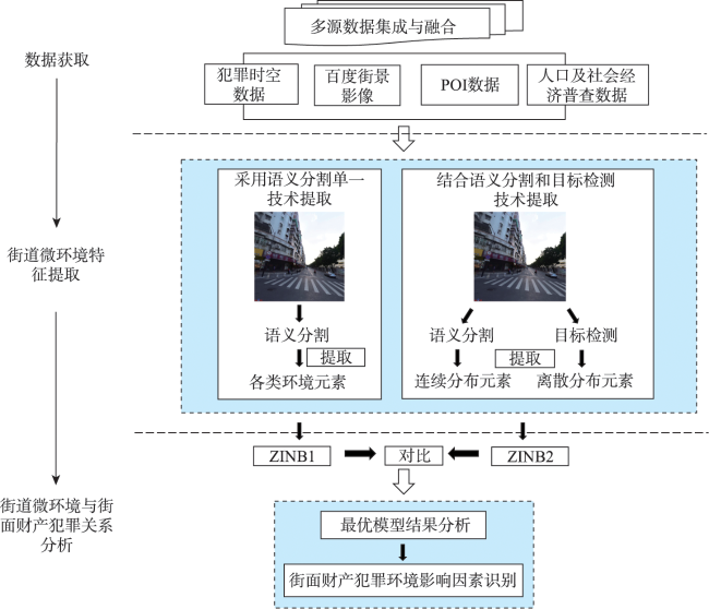
作为城市的骨架,街道网络是人们日常活动的重要载体,其也在很大程度上影响着犯罪事件的分布。因此,街道微环境是研究街面犯罪空间格局及其影响机制的重要切入点。已有研究中基于街景影像的街道微环境度量,多采用语义分割单一技术提取各类环境要素在影像中的像素占比,但该方法不适宜提取行人等离散要素。近期有学者结合使用语义分割和目标检测2种技术来提取影像中复杂的环境要素,但2种方法提取的微环境要素对街面犯罪的解释还未有比较研究。为探究这一问题,本文将百度街景影像作为街道层级建成环境数据,采用上述2种做法分别提取并获得街道微观环境特征变量:第1种做法仅使用语义分割技术将所有要素以像素比例度量;第2种做法用语义分割技术将人行道、建筑、墙面、栅栏、树木和草地以像素比例度量,而用目标检测技术将街面行人和路灯以个数度量。在控制了土地利用混合度、集中劣势、街道长度和密度、犯罪吸引器和发生器后,构建零膨胀负二项回归模型以分析街道微环境特征与街面财产犯罪(如街面盗窃、扒窃)间的关系。模型中分别加入通过两种方式提取的街道微环境特征变量,并比较其对街面财产犯罪影响的差异。研究结果表明: ① 与采用语义分割单一技术提取的街道微环境特征相比,加入了结合使用语义分割和目标检测两种技术提取的街道微环境特征之后,模型表现更好,对街面财产犯罪的解释力提升了7%;尤其是对于街面行人而言,采用目标检测方法对街面行人进行计数,比采用语义分割方法提取行人的像素占比更能有效反映路段上的行人规模,其与街面财产犯罪的关联性更强,其回归系数从0.09提升到0.32,其回归系数绝对值排序从第十位提升至第三位; ② 基于街景影像提取的街道微环境特征能有效解释街面财产犯罪的发生,其中作案目标、活动支持2个维度的街道微环境特征对街面财产犯罪都产生显著影响。具体地说,街面行人规模与街面财产犯罪,如街面盗窃、扒窃,存在显著的正相关关系,而人行道、建筑、树木、草坪在影像中的平均像素占比和绿视率等均与街面财产犯罪存在显著的负相关关系。本文的研究结果对犯罪地理和环境犯罪学文献做了有益的补充,尤其在通过环境设计来预防犯罪方面。

柳林 , 谢华芳 , 岳瀚 . 不同街景影像微环境提取方法对街面财产犯罪解释的差异分析[J]. 地球信息科学学报, 2023 , 25(7) : 1432 -1447 . DOI: 10.12082/dqxxkx.2023.220917
The street network channels people's routine activities, which in turn affects the distribution of crime incidents. Therefore, the street micro-environment is crucial to the fine-grained understanding and explanation of the spatial distribution of street crime. In the existing research on street micro-environment extraction from street view images, semantic segmentation technique is often used to calculate the pixel proportions of various elements, without identifying individual features and objects on street. Recently, some scholars have combined semantic segmentation and object detection technologies to extract complex street environment features, generating both pixel proportions and object counts. However, no research has compared the associations between street crime and the micro-environment features extracted by the two methods. In order to explore this issue, this study used the above two methods to extract street micro-environmental features from Baidu Street View images. The first method used semantic segmentation technique to extract pixel proportions of all features. The second method combined a semantic segmentation and an object detection technology to extract the pixel proportions or counts of individual features, e.g., sidewalk, building, wall, fence, tree, and grass were measured as pixel proportions, and people and light posts on street were measured as counts. After controlling for land use mixture, concentrated disadvantage, street density, length of street segment, and facilities that attract or generate crime, zero-inflated negative binomial regression models were constructed to assess the impacts of the street micro-environmental features on street property crime, such as street theft and pickpocketing. The above two street micro-environment measurements were added to the models separately, and their influences on street property crime were then compared. The results show that: (1) compared with the conventional semantic segmentation method, adding the street micro-environment features extracted by combining semantic segmentation and object detection techniques increased the model performance by 7%. Specifically, the number of pedestrians obtained by the object detection method can better reflect the actual size of people on the street than the pixel proportion of pedestrians obtained by the semantic segmentation method, resulting a stronger association between pedestrians and street property crime. Its regression coefficient increased from 0.09 to 0.32, and the order of the absolute value of the regression coefficient increased from the tenth place to the third place; (2) the street micro-environment features extracted from street view images can effectively explain the occurrence of street property crimes. Crime targets and activity support features can significantly affect street property crime. Specifically, there were significant positive associations between the number of pedestrians on the street and street property crime, and significant negative associations between pixel proportions of sidewalks, buildings, trees, lawns, and green-rate, and the street property crime. This research adds more evidence to the literature of crime geography and environmental criminology, especially for Crime Prevention Through Environment Design (CPTED).
表1 变量描述性统计Tab. 1 Descriptive statistics of variables |
| 变量类别 | 变量名 | 均值 | 标准差 | 最小值 | 最大值 | ||
|---|---|---|---|---|---|---|---|
| 因变量 | 街面财产犯罪/起 | 28.680 0 | 48.920 0 | 0 | 838 | ||
| 自变量 | 人口与社会 经济变量 | 社会经济劣势 | 1.195 0 | 0.318 0 | 0.452 0 | 2.213 0 | |
| 犯罪发生器/百个 | 0.815 0 | 1.125 0 | 0 | 18.170 0 | |||
| 犯罪吸引器/百个 | 0.050 0 | 0.064 5 | 0 | 0.630 0 | |||
| 土地利用混合度 | 0.761 0 | 0.168 0 | 0 | 0.909 0 | |||
| 路网密度/(km/km2) | 26.560 0 | 9.634 0 | 5.213 0 | 66.410 0 | |||
| 路段长度/m | 0.374 0 | 0.276 0 | 0.025 4 | 2.974 0 | |||
| 街景变量 | 作案目标 | 行人/% | 0.003 6 | 0.005 2 | 0 | 0.107 8 | |
| 行人/百人 | 1.466 0 | 1.741 0 | 0 | 16.830 0 | |||
| 人行道/% | 0.034 8 | 0.022 9 | 0 | 0.158 0 | |||
| 建筑/% | 0.197 0 | 0.127 0 | 0 | 0.647 0 | |||
| 步行适宜性 | 0.647 0 | 17.750 0 | 0 | 959.500 0 | |||
| 通道控制 | 墙面/% | 0.028 8 | 0.035 0 | 0 | 0.382 0 | ||
| 栅栏/% | 0.009 1 | 0.009 0 | 0 | 0.109 0 | |||
| 街道围合感 | 3.111 0 | 27.900 0 | 0 | 901.900 0 | |||
| 领地监视 | 路灯/% | 0.000 3 | 0.000 4 | 0 | 0.006 1 | ||
| 路灯/百个 | 0.419 0 | 0.437 0 | 0 | 4.920 0 | |||
| 活动支持 | 树木/% | 0.174 0 | 0.101 0 | 0 | 0.514 0 | ||
| 草坪/% | 0.006 5 | 0.013 7 | 0 | 0.137 0 | |||
| 绿视率 | 4.781 0 | 4.908 0 | 0 | 55.010 0 | |||
表2 模型1和模型2的结果Tab. 2 The results of model 1 and model 2 |
| 变量 | 街面财产犯罪 | ||||||||||||||
|---|---|---|---|---|---|---|---|---|---|---|---|---|---|---|---|
| 仅包含比例变量 (Model 1) | 包含计数变量 (Model 2) | ||||||||||||||
| Count模型 | Logit模型 | Count模型 | Logit模型 | ||||||||||||
| Coef. | OR | Coef. | OR | Coef. | OR | Coef. | OR | ||||||||
| 控制变量 | 社会经济劣势 | 0.15*** | 1.16 | -0.03 | 0.97 | 0.14*** | 1.16 | 0.09 | 1.09 | ||||||
| 犯罪发生器 | 0.63*** | 1.89 | -4.97*** | 0.01 | 0.48*** | 1.61 | -2.20** | 0.11 | |||||||
| 犯罪吸引器 | 0.10*** | 1.10 | -0.83 | 0.44 | 0.09*** | 1.09 | -0.46 | 0.63 | |||||||
| POI混合度 | 0.44*** | 1.55 | -0.19 | 0.82 | 0.40*** | 1.49 | -0.15 | 0.86 | |||||||
| 路网密度 | 0.13*** | 1.14 | -0.05 | 0.95 | 0.14*** | 1.15 | --0.02 | 0.98 | |||||||
| 路段长度 | 0.39*** | 1.47 | -3.68*** | 0.03 | 0.27*** | 1.30 | -1.81*** | 0.16 | |||||||
| 街景变量 | 街面行人 | 0.09*** | 1.10 | -0.43 | 0.65 | 0.32*** | 1.37 | -7.63*** | 0.00 | ||||||
| 人行道 | -0.07*** | 0.93 | 0.00 | 1.00 | -0.10*** | 0.90 | 0.09 | 1.09 | |||||||
| 建筑 | -0.05 | 0.96 | -0.60*** | 0.55 | -0.09*** | 0.91 | -0.25 | 0.78 | |||||||
| 步行适宜性 | -0.19 | 0.83 | 1.23 | 3.44 | -0.09 | 0.91 | 0.57 | 1.76 | |||||||
| 墙面 | -0.10*** | 0.90 | 0.00 | 1.00 | -0.08*** | 0.93 | 0.05 | 1.05 | |||||||
| 栅栏 | 0.01 | 1.01 | -0.00 | 0.99 | 0.00 | 1.00 | 0.04 | 1.04 | |||||||
| 街道围合感 | -0.03 | 0.97 | 0.01 | 1.01 | -0.03 | 0.97 | 0.06 | 1.06 | |||||||
| 路灯 | 0.02 | 1.02 | 0.15 | 1.17 | 0.02 | 1.02 | 0.61 | 1.84 | |||||||
| 树木 | -0.05 | 0.96 | -0.55*** | 0.58 | -0.07 | 0.93 | -0.06 | 0.95 | |||||||
| 草坪 | -0.13*** | 0.88 | 0.15 | 1.17 | -0.10*** | 0.91 | 0.19** | 1.21 | |||||||
| 绿视率 | -0.07 | 0.93 | 1.44*** | 4.22 | -0.07 | 0.93 | 0.37 | 1.45 | |||||||
| 常数项 | 2.93*** | 18.82 | -7.20*** | 0.00 | 2.94*** | 18.89 | -9.04*** | 0.00 | |||||||
| 伪R2 | 0.085 | 0.091 | |||||||||||||
| 最大似然比 (MLL) | -11 281.626 | -11 207.307 | |||||||||||||
| 赤池信息准则 (AIC) | 22 637.251 | 22 488.614 | |||||||||||||
| 伪R2的提升比例 | 7.058% | ||||||||||||||
注: ** 表示p < 0.05, *** 表示p < 0.01。 |
| [1] |
单勇, 阮重骏. 城市街面犯罪的聚集分布与空间防控——基于地理信息系统的犯罪制图分析[J]. 法制与社会发展, 2013, 19(6):88-100.
[
|
| [2] |
张丽英, 裴韬, 陈宜金, 等. 基于街景图像的城市环境评价研究综述[J]. 地球信息科学学报, 2019, 21(1):46-58.
[
|
| [3] |
叶宇, 戴晓玲. 新技术与新数据条件下的空间感知与设计运用可能[J]. 时代建筑, 2017(5):6-13.
[
|
| [4] |
|
| [5] |
张旭, 柳林, 周翰林, 等. 基于贝叶斯逻辑回归模型研究百度街景图像微观建成环境因素对街面犯罪的影响[J]. 地球信息科学学报, 2022, 24(8):1488-1501.
[
|
| [6] |
|
| [7] |
|
| [8] |
|
| [9] |
|
| [10] |
|
| [11] |
柳林, 陈德宝, 徐冲, 等. 入室盗窃临近重复案件与孤立案件分布的影响因素对比研究[J]. 地理科学, 2021, 41(9):1625-1633.
[
|
| [12] |
|
| [13] |
|
| [14] |
|
| [15] |
|
| [16] |
张延吉, 林钦熙, 朱春武, 等. 可渗透性环境对盗窃犯罪分布的影响及社会解组的调节作用——兼论街道眼理论与防卫空间理论的适用性[J]. 地理科学进展, 2022, 41(6):1041-1052.
[
|
| [17] |
|
| [18] |
柳林, 孙秋远, 肖露子, 等. 涉毒人员日常活动对盗窃警情空间格局影响的时间差异[J]. 地球信息科学学报, 2021, 23(12):2187-2200.
[
|
| [19] |
|
| [20] |
|
| [21] |
|
| [22] |
|
| [23] |
刘歆懿, 毛媛媛, 孙溢, 等. 盗窃案件高发居住区的绿化环境特征初探[J]. 江苏建筑, 2019(S1):140-144.
[
|
| [24] |
张艺鸽, 杨芳绒, 王梦瑶. 基于CPTED理论和空间句法的城市公园犯罪防控分析——以郑州市人民公园、紫荆山公园为例[J]. 西南大学学报(自然科学版), 2022, 44(1):202-212.
[
|
| [25] |
|
| [26] |
|
| [27] |
|
| [28] |
|
| [29] |
柳林, 姜超, 李璐. 警用视频监控的犯罪防控效果及空间差异——以苏州市姑苏区为例[J]. 地理科学, 2019, 39(1):61-69.
[
|
| [30] |
|
| [31] |
|
| [32] |
|
| [33] |
曾敏玲, 毛媛媛, 黄伟. 街道网络结构与街道两抢一盗犯罪关系研究——基于空间句法的视角[J]. 城市发展研究, 2014, 21(7):56-63.
[
|
| [34] |
|
| [35] |
|
| [36] |
|
| [37] |
|
| [38] |
|
| [39] |
|
| [40] |
|
| [41] |
|
| [42] |
|
| [43] |
|
| [44] |
|
| [45] |
|
| [46] |
|
| [47] |
|
| [48] |
|
| [49] |
|
| [50] |
龙冬平, 柳林, 陈建国, 等. 街头抢劫者前犯罪经历对其后作案地选择的影响[J]. 地理科学进展, 2020, 39(5):815-828.
[
|
| [51] |
|
| [52] |
|
| [53] |
|
| [54] |
|
| [55] |
|
| [56] |
刘大千, 修春亮, 宋伟. 基于因子分析的长春市犯罪分区研究[J]. 人文地理, 2015, 30(5):38-42,64.
[
|
| [57] |
|
| [58] |
|
/
| 〈 |
|
〉 |
