
适用于海岛的ICESat-2高程控制点提取方法
|
戴泽源(1994— ),男,福建长汀人,博士生,主要从事海上作战环境保障研究。E-mail: carl-day@foxmail.com |
收稿日期: 2022-11-07
修回日期: 2022-12-11
网络出版日期: 2023-07-14
基金资助
国家自然科学基金项目(41871369)
国家自然科学基金项目(41871295)
国家自然科学基金项目(41901320)
国家自然科学基金项目(42071439)
A Method of Island Elevation Control Point Extraction Utilizing ICESat-2 Data
Received date: 2022-11-07
Revised date: 2022-12-11
Online published: 2023-07-14
Supported by
National Natural Science Foundation of China(41871369)
National Natural Science Foundation of China(41871295)
National Natural Science Foundation of China(41901320)
National Natural Science Foundation of China(42071439)
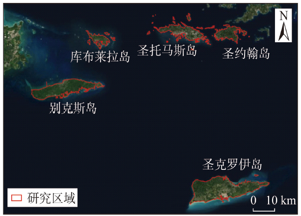
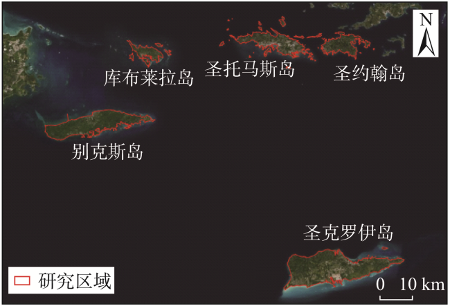
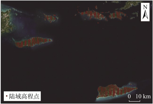
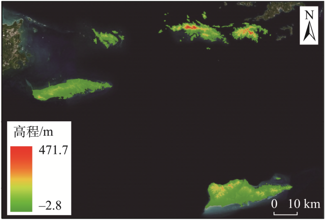
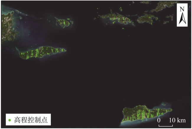
针对海岛控制信息获取困难这一现实问题,提出一种基于ICESat-2 ATL08数据的海岛高程控制点提取方法。首先,通过水域掩膜标记与参考高程数据,去除数据中的海域点与粗差点,降低后续处理的数据量;然后,综合分析大气环境、信噪比、数据完整性等因素对高程值的影响,构建多参数约束初步筛选数据;最后,充分利用数据中的已有参数信息,结合控制点精度指标设计自适应地形阈值对高程控制点进行精细化提取。以波多黎各部分离岛及美属维尔京群岛高精度DEM(Digital Elevation Model)数据验证所提取高程控制点的准确性,实验结果表明:相较于原始数据,本文方法提取的高程控制点在平地、丘陵和山地区域的平均绝对误差与中误差分别从2.65 m/7.23 m、3.92 m/7.65 m、4.93 m/8.29 m减小为0.28 m/0.61 m、0.46 m/0.79 m、0.63 m/0.89 m;在保证精度的前提下,本文方法提取的高程控制点数量显著多于现有方法;利用本文方法,可从海岛区域提取一定数量、精度可靠的高程控制点,能为后续全球海图修测与质量控制提供有力数据支撑。
戴泽源 , 张立华 , 张林 , 刘翔 , 周寅飞 , 陈秋 . 适用于海岛的ICESat-2高程控制点提取方法[J]. 地球信息科学学报, 2023 , 25(8) : 1559 -1569 . DOI: 10.12082/dqxxkx.2023.220868
To address the challenge of island elevation control information acquisition, a method of island elevation control point extraction based on ICESat-2 ATL08 data is proposed. Firstly, the sea area points and the gross error points in the data are deleted via the water area mask and the reference data, which reduces the volume of data waiting to be processed. Then, considering the impact of the atmospheric environment, signal-to-noise ratio, and data integrity on the accuracy of elevation control points, the data are preliminary screened with multiparameter restrictions. Finally, an adaptive terrain threshold is determined to extract the elevation control points based on the precision index. The accuracy of the extracted elevation control points are validated using high-precision Digital Elevation Model (DEM) data from various islands in Puerto Rico's outlying islands and the United States Virgin Islands. The experimental results show that, compared to the original data, the Mean Absolute Error (MAE) and Root Mean Square Error (RMSE) of the elevation control points extracted by the proposed method in the flat, hilly, and mountainous regions are reduced from 2.65 m/7.23 m, 3.92 m/7.65 m, and 4.93 m/8.29 m to 0.28 m/0.61 m, 0.46 m/0.79 m, and 0.63 m/0.89m, respectively. On the premise of ensuring accuracy, the number of elevation control points extracted by the proposed method is significantly larger than that of the existing methods. Our proposed method allows for extraction of a specific number of reliable elevation control points from the island region, which provides a solid foundation for the global nautical chart renovation and quality control.
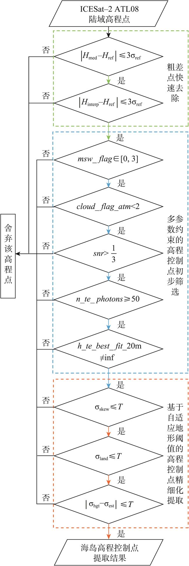
图1 本文方法海岛高程控制点提取流程Fig. 1 Flow chart of the proposed elevation control point extraction method |
表1 本文方法用于高程控制点提取的ATL08数据参数Tab. 1 ATL08 data parameter used in the proposed elevation point extraction method |
| 参数名 | 简要释义 |
|---|---|
| segment_landcover | 统计单元内的地物类型 |
| h_te_median | 统计单元内地表光子高程中值 |
| h_te_interp | 统计单元内插值地表高程值 |
| dem_h | 参考高程值 |
| msw_flag | 多重散射警告标记 |
| cloud_flag_atm | 云量标记 |
| snr | 统计单元内的信噪比 |
| n_te_photons | 统计单元内地的地表光子数 |
| h_te_best_fit_20m | 20 m子统计单元内的最佳拟合高程值 |
| h_te_skew | 统计单元内地表光子的高程偏度 |
| sigma_atlas_land | 统计单元内地表光子的高程误差预估值 |
| h_te_std | 统计单元内地表光子的高程标准差 |
| terrain_slope | 统计单元内沿轨方向的地面坡度,通过线性拟合得出,数值上等同于沿轨方向上单位长度的高程变化量 |
表2 高程控制点精度验证结果Tab. 2 The accuracy of extracted elevation control point |
| 筛选条件 | 高程点数/个 | MAE/m | RMSE/m | 数据留存率/% |
|---|---|---|---|---|
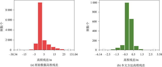
| 原始数据 | 15 388 | 3.86 | 7.89 | 100.00 |
| 粗差点去除 | 11 071 | 1.53 | 2.83 | 71.95 |
| 多参数约束 | 3 055 | 0.57 | 1.38 | 19.85 |
| 自适应地形阈值 | 1 990 | 0.36 | 0.69 | 12.93 |
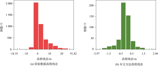
图7 平地地形高程点残差直方图Fig. 7 The histogram of residuals for elevation points in the flat region |
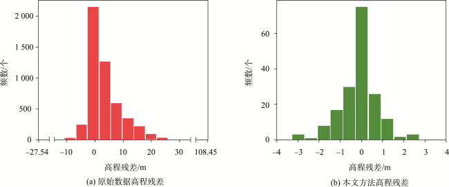
图8 丘陵地形高程点残差直方图Fig. 8 The histogram of residuals for elevation points in the hilly region |
图9 山地地形高程点残差直方图Fig. 9 The histogram of residuals for elevation points in the mountainous region |
表3 不同地形类型下高程控制点精度验证结果Tab. 3 The accuracy of extracted elevation control point with different terrain type |
| 地形类型 | 筛选条件 | 高程点数/个 | MAE/m | RMSE/m | 数据留存率/% | 精度符合率/% |
|---|---|---|---|---|---|---|
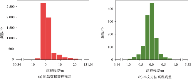
| 平地 | 原始数据 | 5 618 | 2.65 | 7.23 | 100.00 | 61.65 |
| 粗差点去除 | 4 574 | 0.91 | 2.11 | 81.42 | 73.92 | |
| 多参数约束 | 1 836 | 0.39 | 1.06 | 32.68 | 90.58 | |
| 自适应地形阈值 | 1 281 | 0.28 | 0.61 | 22.80 | 93.60 | |
| 丘陵 | 原始数据 | 4 301 | 3.92 | 7.65 | 100.00 | 43.87 |
| 粗差点去除 | 2 983 | 1.51 | 2.73 | 69.36 | 59.94 | |
| 多参数约束 | 763 | 0.66 | 1.44 | 17.74 | 83.88 | |
| 自适应地形阈值 | 532 | 0.46 | 0.79 | 12.37 | 89.10 | |
| 山地 | 原始数据 | 5 138 | 4.93 | 8.29 | 100.00 | 32.21 |
| 粗差点去除 | 3 321 | 2.33 | 3.60 | 64.64 | 45.26 | |
| 多参数约束 | 444 | 1.10 | 2.17 | 8.64 | 74.77 | |
| 自适应地形阈值 | 177 | 0.63 | 0.89 | 3.44 | 86.44 |
表4 不同地形类型下高程控制点限差符合率Tab. 4 Compliance rate of elevation point tolerance before and after adaptive terrain threshold filtering |
| 地形类型 | 筛选条件 | 限差符合率/% |
|---|---|---|
| 平地 | 自适应地形阈值筛选前 | 95.59 |
| 自适应地形阈值筛选后 | 98.05 | |
| 丘陵 | 自适应地形阈值筛选前 | 93.70 |
| 自适应地形阈值筛选后 | 96.24 | |
| 山地 | 自适应地形阈值筛选前 | 90.77 |
| 自适应地形阈值筛选后 | 97.18 |
表5 不同高程控制点提取方法结果对比分析Tab. 5 Comparison of elevation control point extraction results by different methods |
| [1] |
申家双, 翟国君, 黄辰虎, 等. 海洋测绘学科体系研究(一):总论[J]. 海洋测绘, 2021, 41(1):1-7.
[
|
| [2] |
胡柳茹, 唐新明, 李国元, 等. 利用GLAS激光测高数据评估DSM产品质量及精度优化[J]. 测绘通报, 2019(11):39-43.
[
|
| [3] |
朱笑笑, 王成, 习晓环, 等. ICESat-2星载光子计数激光雷达数据处理与应用研究进展[J]. 红外与激光工程, 2020, 49(11):76-85.
[
|
| [4] |
张鑫磊, 邢帅, 徐青, 等. ATLAS数据与资源三号02星影像联合区域网平差[J]. 红外与激光工程, 2020, 49(S2):155-162.
[
|
| [5] |
|
| [6] |
滕惠忠, 闸旋, 辛宪会, 等. 基于ArcGIS的海图立体修测技术[J]. 海洋测绘, 2015, 35(5):63-66.
[
|
| [7] |
周艳霞, 李彬彬, 方强飞, 等. 海图产品质量模糊综合评判模型的构建方法[J]. 海洋测绘, 2020, 40(3):55-59.
[
|
| [8] |
李国元. 对地观测卫星激光测高数据处理方法与工程实践[D]. 武汉: 武汉大学, 2017.
[
|
| [9] |
李国元, 唐新明, 张重阳, 等. 多准则约束的ICESat/GLAS高程控制点筛选[J]. 遥感学报, 2017, 21(1):96-104.
[
|
| [10] |
谭建伟, 程春泉. 建筑影像高程控制点的激光测高全波形分解提取[J]. 测绘科学, 2021, 46(8):1-7,13.
[
|
| [11] |
|
| [12] |
唐新明, 谢俊峰, 莫凡, 等. 高分七号卫星双波束激光测高仪在轨几何检校与试验验证[J]. 测绘学报, 2021, 50(3):384-395.
[
|
| [13] |
梅永康, 谢俊峰, 陈伟, 等. 多特征参数约束的星载激光高程控制点提取[J]. 红外与激光工程, 2022, 51(9):246-257.
[
|
| [14] |
|
| [15] |
|
| [16] |
|
| [17] |
|
| [18] |
|
| [19] |
|
| [20] |
王密, 韦钰, 杨博, 等. ICESat-2/ATLAS全球高程控制点提取与分析[J]. 武汉大学学报·信息科学版, 2021, 46(2):184-192.
[
|
| [21] |
郑迎辉, 张艳, 王涛, 等. 基于ICESat-2数据的高程控制点提取和精度验证[J]. 地球信息科学学报, 2022, 24(7):1234-1244.
[
|
| [22] |
|
| [23] |
|
| [24] |
刘翔, 张立华, 戴泽源, 等. 一种无输入参数的强噪声背景下ICESat-2点云去噪方法[J]. 光子学报, 2022, 51(11):354-364.
[
|
| [25] |
|
| [26] |
|
| [27] |
Ice, Cloud, and Land Elevation Satellite - 2 (ICESat-2) ProjectATL08 Product Data Dictionary[EB/OL]. (2021-07-27) [2022-11-07] https://nsidc.org/sites/default/files/icesat2_atl08_data_dict_v005_0.pdf
|
| [28] |
国家质量技术监督局. 中国航海图编绘规范: GB 12320—1998[S]. 北京: 中国标准出版社,1999.
[State Bureau of Quality and Technical Supervision of the People's Republic of China. Specifications for Chinese nautical charts: GB 12320—1998[S]. Beijing: Standards Press of China, 1999.]
|
| [29] |
国家市场监督管理总局, 国家标准化管理委员会. 数字航天摄影测量—控制测量规范: GB/T 40766—2021[S]. 北京: 中国标准出版社, 2021.
[State Administration for Market Regulation, Standardization Administration of the People's Republic of China. Digital space photogrammetry—Specifications for control survey: GB/T 40766—2021[S]. Beijing: Standards Press of China, 2021.]
|
| [30] |
郑琪. 激光跟踪仪测量精度分析及高精度三维控制网的建立[D]. 武汉: 武汉大学, 2019.
[
|
/
| 〈 |
|
〉 |