
顾及地形影响的火星地表天文辐射时空特征分析
|
涂平(1973— ),男,福建长汀人,副研究员,主要从GIS软件开发与技术支持研究。E-mail: tupingADC@163.com |
收稿日期: 2022-08-01
修回日期: 2022-09-10
网络出版日期: 2023-07-14
基金资助
国家自然科学基金项目(41771423)
Spatiotemporal Characteristics of Astronomical Solar Radiation for Martian Surface under Terrain Influence
Received date: 2022-08-01
Revised date: 2022-09-10
Online published: 2023-07-14
Supported by
National Natural Science Foundation of China(41771423)
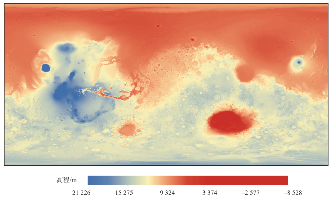
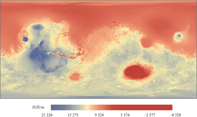
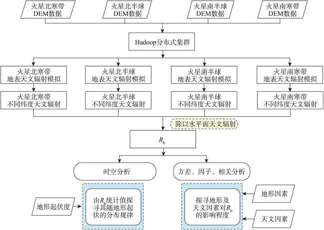
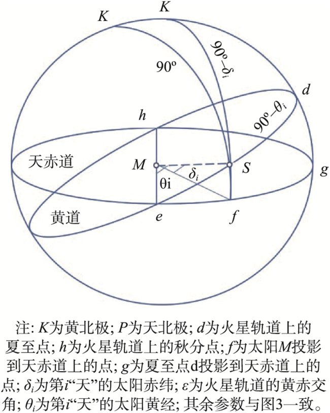
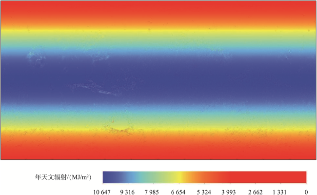
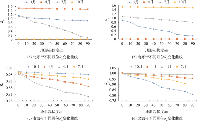
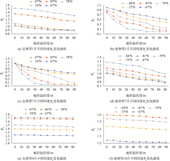
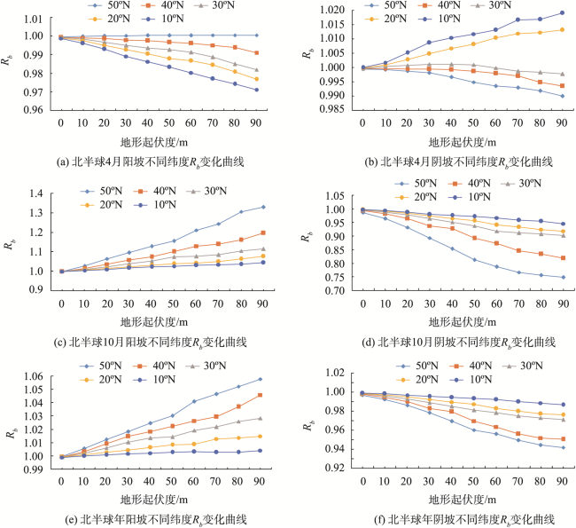
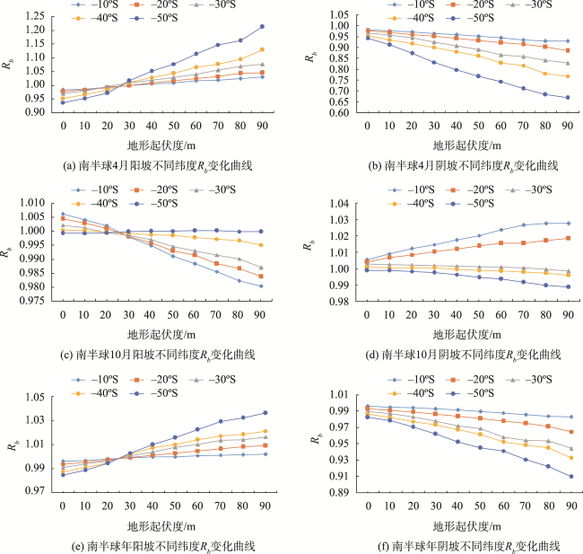
天文辐射指不考虑大气影响,落于地表的太阳辐射类型,亦是太阳能资源评估的重要背景。火星天文辐射及其时空分布特征的研究会为未来火星的探索提供助力,为火星太阳能资源的精细化利用和高效开发以及政府的科学决策提供基础数据。火星地形地貌错综复杂,其规模形态地球难以比拟,故而无法忽略地形对火星地表天文辐射的影响效果。然而,当下对火星天文辐射的计算和研究并未考虑火星实际地表的遮蔽效应且往往是从局部区域进行的研究。本文考虑纬度差异、时序更替的综合影响,以分辨率200 m的数字高程模型作为基本数据,提出了基于DEM计算火星天文辐射的理论模型,利用 Hadoop分布式集群提供的并行计算框架以10 min为一个时间单位精细模拟了考虑地形遮蔽影响的火星全球地表天文辐射空间分布。 为水平面天文辐射与考虑地形遮蔽因素的天文辐射之比,一般用于评估天文辐射的地形遮蔽程度。基于全球不同纬度使用 进行时空分析,通过有交互的双因素方差分析、因子分析、相关性分析探寻地形因子及天文因素对阴坡和阳坡 值的影响程度。结果表明:地形对火星全球地表天文辐射的影响效果在时空尺度上具有明显的规律性,其影响程度不仅与地形自身发展情况(包括地形起伏,坡向,纬度等)有关,还深受正午太阳高度角等天文因素的综合影响。
涂平 , 林偲蔚 , 周千千 , 谢静 , 范玉贵 , 陈楠 , 林伟斌 , 郭连鹤 . 顾及地形影响的火星地表天文辐射时空特征分析[J]. 地球信息科学学报, 2023 , 25(8) : 1611 -1624 . DOI: 10.12082/dqxxkx.2023.220565
Astronomical solar radiation refers to solar radiation that falls on the Earth regardless of the influence of the atmosphere, which is a significant variable for resource assessment of solar energy. Characterizing the spatial-temporal distribution of Martian astronomical solar radiation can help the Martian exploration in the future, providing basic data for detailed utilization and efficient development of solar energy resources on Mars, as well as assistance for the scientific decision-making of governments. However, the Martian terrain is complicated, and its scale and shape are incomparable to those of the Earth. Therefore, it is impossible to ignore the influence of terrain on astronomical solar radiation on the Martian surface. Current studies of the Martian astronomical solar radiation do not consider the terrain shielding effect of the actual surface of Mars and often focus on local areas. In this paper, the comprehensive influence of latitude difference and time sequence replacement is considered. The Digital Elevation Model (DEM) with a resolution of 200 m is taken as the basic data, and a theoretical model for calculating Martian astronomical radiation based on DEM is proposed. The parallel computing framework provided by Hadoop distributed cluster is used to simulate the spatial distribution of astronomical radiation on the Martian global surface, by considering the impact of terrain, and taking 10 minutes as a time unit. The Rb is the ratio between the horizontal astronomical solar radiation and the astronomical solar radiation considering the terrain shielding effect, which is generally used to evaluate the terrain shielding effect of astronomical solar radiation. Based on the mean Rb corresponding to different global latitudes, the spatiotemporal analysis is carried out. Through interactive two-factor analysis of variance, factor analysis, and correlation analysis, the influence extent of terrain factors and astronomical factors on Rb value of shady slope and sunny slope is explored. The results show that the influence of terrain on the Martian surface has obvious regularity at the spatial-temporal scale, and the influence degree is not only related to the development of topography itself, but also affected by astronomical factors such as the height angle of the midday sun.
表1 有交互作用的阳坡 方差分析Tab. 1 Results of variance analysis of tailo with interaction |
| 方差来源 | 平方和 | 自由度 | F值 | 检验P值 |
|---|---|---|---|---|
| 因素A:起伏度 | 0.089 691 | 12 | 5.474 144 | 5.163 134 |
| 因素B:纬度 | 0.042 988 | 4 | 7.8711150 | 6.685 093 |
| 交互 | 0.049 817 | 48 | 0.760 127 | 0.868 894 2 |
| 误差 | 0.266 547 | 195 |
表2 有交互作用的阴坡 方差分析Tab. 2 Results of variance analysis of Schattenseite with interaction |
| 方差来源 | 平方和 | 自由度 | F值 | 检验P值 |
|---|---|---|---|---|
| 因素A:起伏度 | 0.140 069 | 12 | 2.035444 | 2.309 153 |
| 因素B:纬度 | 0.318 313 | 4 | 13.876 88 | 5.591 603 |
| 交互 | 0.069 776 | 48 | 0.253 49 | 0.998 624 6 |
| 误差 | 1.118 246 | 195 |
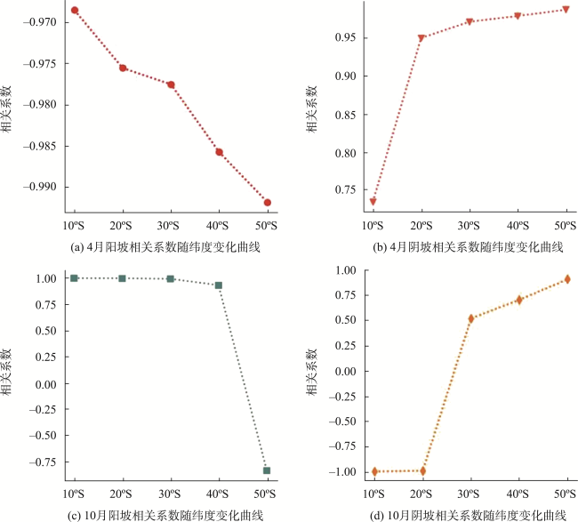
图10 不同纬度 与地形开阔度之间的相关系数曲线图Fig. 10 Correlation curves of in different latitude and terrain breadth |
表3 受地形开阔度影响百分比Tab. 3 Table of percentage of affected by terrain breadth |
| 纬度/°S | 4月阳坡/% | 4月阴坡/% | 10月阳坡/% | 10月阴坡/% |
|---|---|---|---|---|
| 50 | 29.13 | 30.90 | 0.11 | 1.47 |
| 40 | 14.79 | 20.78 | 0.58 | 0.16 |
| 30 | 11.04 | 13.78 | 1.54 | 0.32 |
| 7.00 | 9.35 | 2.07 | 1.73 | |
| 10 | 4.82 | 6.99 | 2.86 | 1.92 |
表4 因子分析Tab. 4 Results of factor analysis |
| 阳坡4月 | F1 | F2 | F3 | 共同度 |
|---|---|---|---|---|
| 因子载荷 | -0.432 | -0.901 | -0.030 | 0.99 980 |
| 0.904 | 0.422 | 0.062 | 0.99 980 | |
| 0.923 | 0.375 | -0.083 | 0.99 995 | |
| 0.865 | 0.455 | 0.212 | 0.99 995 | |
| 方差贡献率 | 0.652 | 0.337 | 0.056 | — |
| 累计贡献率 | 0.652 | 0.989 | 0.995 | — |
| 阳坡10月 | F1 | F2 | F3 | 共同度 |
| 因子载荷 | 0.529 | 0.378 | 0.759 | 0.99 869 |
| 0.834 | 0.356 | 0.420 | 0.99 887 | |
| -0.362 | -0.884 | -0.296 | 0.99 992 | |
| 0.772 | 0.479 | 0.415 | 0.99 812 | |
| 方差贡献率 | 0.426 | 0.320 | 0.253 | — |
| 累计贡献率 | 0.426 | 0.746 | 0.999 | — |
| 阴坡4月 | F1 | F2 | F3 | 共同度 |
| 因子载荷 | 0.816 | 0.578 | -0.027 | 0.99 996 |
| 0.674 | 0.737 | 0.034 | 0.99 997 | |
| 0.556 | 0.831 | 0.006 | 0.99 996 | |
| 0.778 | 0.624 | 0.074 | 0.99 997 | |
| 方差贡献率 | 0.509 | 0.489 | 0.002 | — |
| 累计贡献率 | 0.509 | 0.998 | 0.999 | — |
| 阴坡10月 | F1 | F2 | F3 | 共同度 |
| 因子载荷 | -0.962 | 0.271 | 0.035 | 0.99 999 |
| 0.882 | -0.462 | 0.093 | 0.99 996 | |
| -0.348 | 0.937 | -0.019 | 0.99 999 | |
| 0.799 | -0.581 | 0.156 | 0.99 998 | |
| 方差贡献率 | 0.615 | 0.376 | 0.008 | — |
| 累计贡献率 | 0.615 | 0.991 | 0.999 | — |
表5 各纬度下各公共因子的得分情况Tab. 5 Scores of common factors at different latitudes |
| 综合得分 | 10 °S | 20 °S | 30 °S | 40 °S | 50 °S |
|---|---|---|---|---|---|
| 4月阳坡 | 1.402 | 1.302 | 1.104 | 1.057 | 0.758 |
| 10月阳坡 | 1.305 | 1.354 | 1.384 | 1.542 | 1.699 |
| 4月阴坡 | 1.099 | 0.958 | 0.731 | 0.524 | 0.083 |
| 10月阴坡 | 1.507 | 2.175 | 2.608 | 2.986 | 3.230 |
表6 相关系数t与样本统计量TTab. 6 Correlation coefficient t and sample statistic T |
| 不同月份坡向 | 相关系数t | 样本统计量T |
|---|---|---|
| 4月阳坡 | -0.894 | -3.381 |
| 10月阳坡 | 0.944 | 4.971 |
| 4月阴坡 | 0.996 | 24.875 |
| 10月阴坡 | -0.995 | -16.848 |
| [1] |
孙汉群. 坡面日照和天文辐射研究[M]. 南京: 河海大学出版社, 2005:231-232.
[
|
| [2] |
|
| [3] |
|
| [4] |
|
| [5] |
|
| [6] |
|
| [7] |
|
| [8] |
史建奎, 刘振兴. 火星探测的科学意义(2004年科学发展报告)[M]. 北京: 科学出版社, 2004.
[
|
| [9] |
|
| [10] |
|
| [11] |
|
| [12] |
|
| [13] |
|
| [14] |
|
| [15] |
|
| [16] |
|
| [17] |
|
| [18] |
周文臻, 陈楠. 天文辐射空间分布与尺度效应研究[J]. 地球信息科学学报, 2018, 20(2):186-195.
[
|
| [19] |
|
| [20] |
|
| [21] |
|
| [22] |
|
| [23] |
|
| [24] |
|
| [25] |
曾燕, 邱新法, 刘昌明, 等. 基于DEM的黄河流域天文辐射空间分布[J]. 地理学报, 2003,(6):810-816.
[
|
| [26] |
林超, 李昌文. 阴阳坡在山地地理研究中的意义[J]. 地理学报, 1985, 40(1):20-28.
[
|
| [27] |
|
| [28] |
韩同林, 孟宪刚, 邵赵刚, 等. 火星地貌与地质[M]. 北京: 地质出版社, 2007.
[
|
| [29] |
邓自立. 云计算中的网络拓扑设计和Hadoop平台研究[D]. 合肥: 中国科学技术大学, 2009.
[
|
| [30] |
侯建文, 张晓岚, 王燕. 火星探测征程[M]. 北京: 中国宇航出版社, 2013.
[
|
| [31] |
|
| [32] |
左大康. 现代地理学的理论与实践地球表层辐射研究[M]. 北京: 科学出版社, 1991.
[
|
| [33] |
金祖孟, 陈自悟. 地球概论(第三版)[M]. 高等教育出版社, 1997.
[
|
| [34] |
|
/
| 〈 |
|
〉 |