
全球网格位置服务在自然资源数据服务中的应用研究
|
吴洪桥(1973—),男,山东滨州人,博士,正高级工程师,主要从事自然资源信息化工程开发与技术研究。 E-mail: wuhq730@163.com |
收稿日期: 2022-03-04
修回日期: 2022-05-02
网络出版日期: 2023-09-05
基金资助
国家重点研发计划专项课题(2018YFB0505305)
Application Research of Global Geo-grid Location Service in Natural Resources Data Service
Received date: 2022-03-04
Revised date: 2022-05-02
Online published: 2023-09-05
Supported by
National Key Research and DevelopmentProgram(2018YFB0505305)
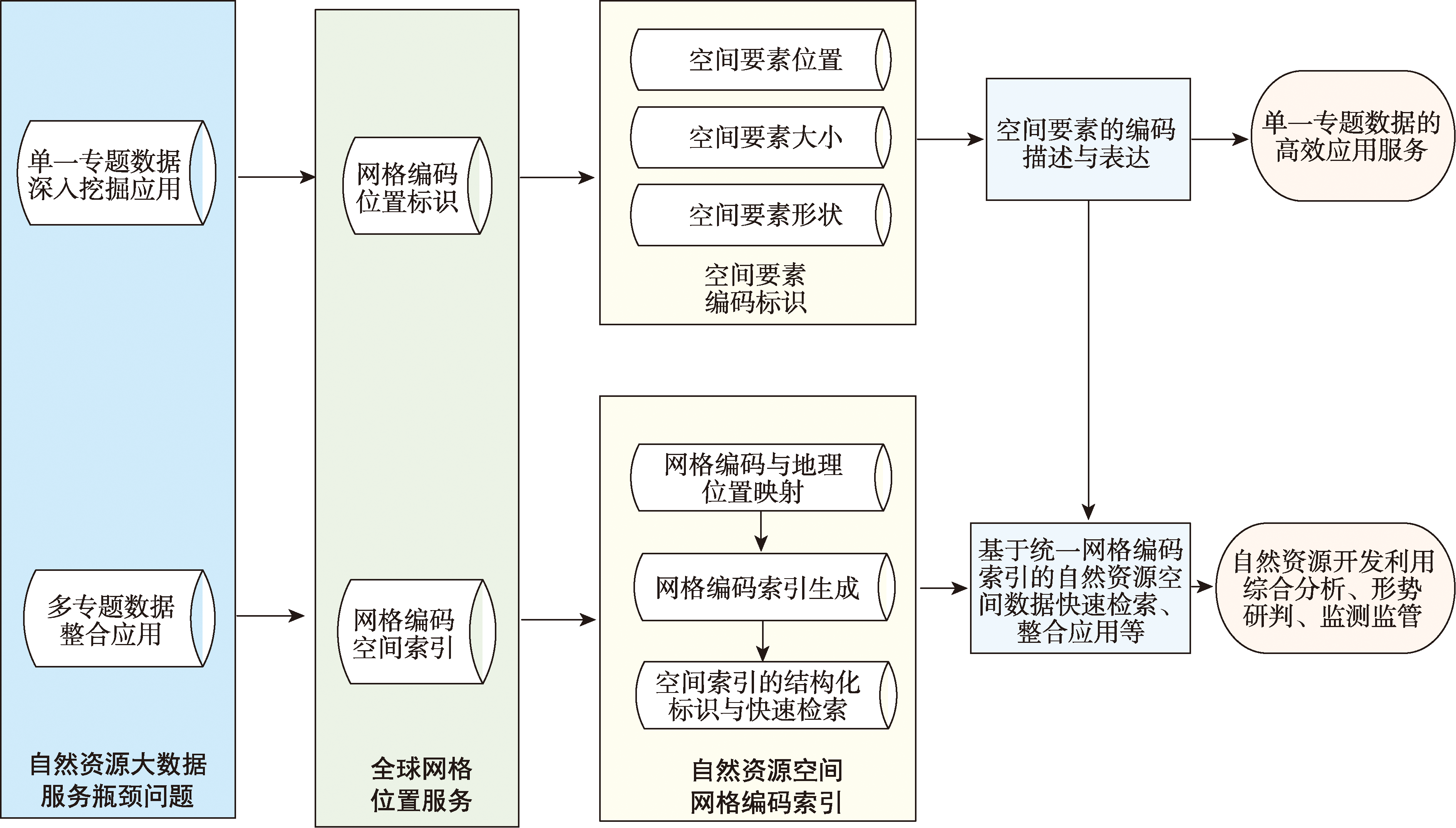
本文以单一专题数据的挖掘应用和多专题数据的整合应用为切入点,研究了基于全球网格剖分和网格编码基础上实现的网格位置服务在自然资源数据服务中的应用。在单一专题数据的挖掘应用方面,本文针对当前不动产登记信息管理与服务现状和具体需求,提出了一种基于不动产单元位置、大小和形状的不动产单元网格剖分编码解决方案。该编码方案实现了不动产单元标识的稳定性、位置关联性与可溯源性等功能特性,解决了现有编码方法在不动产登记信息管理与服务方面的不足,并开展了上述功能特性的业务场景应用验证。在自然资源多专题数据整合应用方面,本文开展了基于全球网格剖分编码的数据组织与索引机制研究和应用,并在土地利用规划、土地利用现状和自然资源不动产等自然资源多专题数据整合方面做了应用和验证,验证了基于网格剖分编码的数据组织与索引机制在自然资源多专题空间要素整合应用方面的高效性。上述研究对于推动全球网格剖分与编码服务在自然资源数据服务中的应用,提升自然资源数据服务能力具有重要意义。

吴洪桥 , 张敬波 , 何维 , 刘聚海 , 郝硕 , 程承旗 . 全球网格位置服务在自然资源数据服务中的应用研究[J]. 地球信息科学学报, 2023 , 25(9) : 1774 -1783 . DOI: 10.12082/dqxxkx.2023.220093
Based on the methods and standards of global grid subdivision, using the National Key Research and Development Program research achievement, i.e., Geo-grid location service in natural resources informatization, this paper investigated how to apply Geo-grid subdivision and grid encoding in real property registration information management and natural resources big data integration. This paper analyzed current situation of natural resources property registration information management and service and proposed a new real property identifier coding scheme based on the Geo-grid location service. This identifier coding scheme is based on the natural attributes such as location, size, shape of a real property unit. This new identifier coding scheme includes real property unit location identifier code and independent property right code. Real property unit location identifier code consists of location grid code, location scale code, longitude span code, latitude span code, and feature code. With a given longitude and latitude string of a real property unit, the real property unit location identifier code can be calculated automatically. Compared with the current identifier coding rule, this new identifier coding scheme realizes the functions of encoding stability, location correlation, and historical traceability. The encoding scheme can overcome the defects of current property identifier coding rule in information management and service. As a functional supplement, this identifier coding schema based on Geo-grid subdivision can be applied in real property registration information management and service with current coding rule. In natural resource big data integration, this paper studied data organization and indexes based on global grid subdivision. By means of setting mapping relationship between real locations of spatial elements and Geo-grid subdivision code, Geo-grid spatial index was established. This paper adopted land use data, land planning data, real property data of XiCheng District, Beijing, and compared two data indexes, Geo-grid spatial index and traditional spatial index. This paper tested the above index scheme in multi-data inquiry and retrieval of land planning, land use, and real property registration. As a result, the above data index scheme is efficient in multi-data integration of natural resources. The spatial index based on Geo-grid subdivision can break the bottleneck of traditional spatial index and improve the ability of multi-data integration. Also, the spatial index could improve the ability of natural resource survey, supervision, and macroscopic analysis. Our studies can promote the application of global grid subdivision and location service in natural resources big data, and improve the ability of natural resource big data management and data service.

| [1] |
兀伟, 邓国庆, 程承旗, 等. 国家标准《地球空间网格编码规则》编制说明[J]. 测绘标准化, 2021, 37(3):5-10.
[
|
| [2] |
北京大学. 《全球位置框架与编码系统》(2018YFB0505300)国家重点研发计划项目申报书[R]. 北京:2018-02-26.
[Peking University. Global Location Framework and Encoding System (2018YFB0505300) National Key Research Project[R]. Beijing:2018-02-26.]
|
| [3] |
李德仁, 肖志峰, 朱欣焰, 等. 空间信息多级网格的划分方法及编码研究[J]. 测绘学报, 2006, 35(1):52-56,70.
[
|
| [4] |
程承旗, 付晨. 地球空间参考网格及应用前景[J]. 地理信息世界, 2014, 21(3):1-8.
[
|
| [5] |
国家市场监督管理总局, 国家标准化管理委员会. 不动产单元设定与代码编制规则: GB/T 37346—2019[S]. 北京: 中国标准出版社, 2019.
[Standardization Administration of the People's Republic of China. Regulation on real property unit formation and identifier coding: GB/T 37346—2019[S]. Beijing: Standards Press of China, 2019.]
|
| [6] |
吴洪桥, 郝硕, 濮国梁, 等. 基于全球剖分网格的不动产编码研究[J]. 地理信息世界, 2020, 27(4):30-35.
[
|
| [7] |
国家市场监督管理总局, 国家标准化管理委员会. 地球空间网格编码规则: GB/T 40087—2021[S]. 北京: 中国标准出版社, 2021.
[Standardization Administration of the People's Republic of China. Geospatial grid encoding rule: GB/T 40087—2021[S]. Beijing: Standards Press of China, 2021.]
|
| [8] |
韩海东, 程承旗, 王燕, 等. 基于全球剖分网格的多源数据快速汇集方法研究[J]. 地理信息世界, 2014, 21(6):6-11.
[
|
| [9] |
宋树华, 董芳, 陈东, 等. 基于GeoSOT剖分编码的不动产单元统一标识模型研究[J]. 测绘学报, 2016, 45(S1):99-105.
[
|
| [10] |
程承旗, 任伏虎, 濮国梁. 空间信息剖分组织导论[M]. 北京: 科学出版社, 2012.
[
|
| [11] |
胡璐锦, 蔡俊, 李海生. 基于时空地理格网的空间数据融合方法[J]. 测绘与空间地理信息, 2018, 41(8):4-7.
[
|
| [12] |
宋树华, 程承旗, 濮国梁, 等. 全球遥感数据剖分组织的GeoSOT网格应用[J]. 测绘学报, 2014, 43(8):869-876.
[
|
| [13] |
李德仁, 崔巍. 地理本体与空间信息多级网格[J]. 测绘学报, 2006, 35(2):143-148.
[
|
| [14] |
金安, 程承旗. 基于全球剖分网格的空间数据编码方法[J]. 测绘科学技术学报, 2013, 30(3):284-287.
[
|
| [15] |
赵学胜, 贲进, 孙文彬, 等. 地球剖分格网研究进展综述[J]. 测绘学报, 2016, 45(S1):1-14.
[
|
| [16] |
Discrete Global Grid Systems Abstract Specification(OGC 15-104R5)[S]. 2017:12-18.
|
| [17] |
|
| [18] |
|
/
| 〈 |
|
〉 |