
地表反射率遥感数据支持的火烧迹地面积提取
|
牛方天(2000— ),男,山东菏泽人,硕士生,研究方向为定量遥感。E-mail: nfangtian@163.com |
收稿日期: 2023-04-27
修回日期: 2023-07-04
网络出版日期: 2023-09-05
基金资助
国家自然科学基金项目(42271412)
Extracting Burned Area with Remotely Sensed Surface Reflectance Data
Received date: 2023-04-27
Revised date: 2023-07-04
Online published: 2023-09-05
Supported by
National Natural Science Foundation of China(42271412)
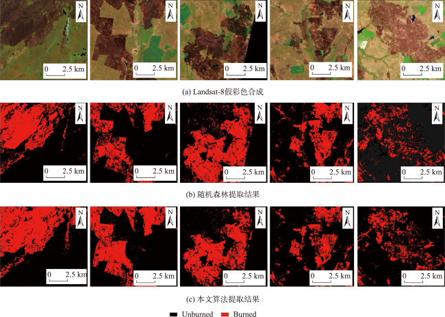
生物质燃烧排放大量烟雾和温室气体对于全球气候变化有显著影响,而准确及时地提取火烧迹地面积对于火灾补救、植被恢复、估算大气排放至关重要。中分辨率成像光谱仪MODIS较高的时间分辨率可以快速获取全球每日的火烧迹地产品,但对于小型和破碎度高的火烧迹地的遗漏率比较高。据此,本研究融合MODIS与Landsat-8 OLI(Operational Land Imager 陆地成像仪)的时空优势,提出了基于地表反射率数据集支持的火烧面积提取算法。首先,使用MODIS地表反射率产品MOD09GA构建燃烧日期前后在红、绿、蓝、近红外和短波红外的先验地表反射率数据集。然后,采用自适应遥感图像时空融合算法 (Spatial and Temporal Adaptive Reflectance Fusion Model, STARFM)以及线性拟合的方法对MODIS与Landsat-8地表反射率数据进行空间和光谱一致化处理。最后,运用自动阈值的方法厘定火烧区域的最佳阈值。此外,通过选取4个不同的燃烧规模样地/样区验证了该算法的火烧迹地面积提取准确率在75%以上。本研究将MODIS的高时间分辨率和Landsat-8的高空间分辨率的优势结合,既解决了单独使用MODIS对小型、破碎度高的火烧迹地提取不足的问题,也验证了基于地表反射率数据集的算法对于火烧迹地实时提取能力。
关键词: 生物质燃烧; 火烧迹地; 先验地表反射率数据集; 光谱一致化; MODIS; Landsat-8 OLI
牛方天 , 孙林 , 于会泳 , 马超 . 地表反射率遥感数据支持的火烧迹地面积提取[J]. 地球信息科学学报, 2023 , 25(9) : 1855 -1868 . DOI: 10.12082/dqxxkx.2023.230232
Biomass burning is a significant source of smoke and greenhouse gas emissions, contributing to global climate change. Accurate and promptly identifying burned area is crucial for effective fire remediation, vegetation recovery, and estimation of atmospheric emissions. While medium to high spatial resolution satellite imagery, like Landsat-8, allows for mapping of small-scale and fragmented burn areas, data availability is limited by long revisit period and cloud cover constraints. Conversely, MODIS provides high temporal resolution, facilitating rapid generation of daily burned area products worldwide. However, it exhibits higher error of omission for small burn areas. To combine the strengths of MODIS' high temporal resolution and Landsat-8's high spatial resolution while addressing the challenges of extracting small and fragmented burn areas and reducing error of omission through continuous time series monitoring, this study proposes a burned area extraction algorithm based on a surface reflectance dataset supported by MODIS and Landsat-8 Operational Land Imager (OLI). Initially, the MODIS surface reflectance product (MOD09GA) is utilized to construct a priori surface reflectance dataset for the red, green, blue, near-infrared, and shortwave infrared bands before and after the burning dates. Subsequently, the Spatial and Temporal Adaptive Reflectance Fusion Model (STARFM) and linear fitting methods are employed to spatially and spectrally normalize the MODIS and Landsat-8 surface reflectance data. Finally, an automatic thresholding method is applied to determine the optimal threshold for delineating burned areas. Additionally, the algorithm's accuracy in extracting burned area is validated using four types of burn samples with varying sizes, achieving an extraction accuracy exceeding 75%. This study successfully combines the high temporal resolution of MODIS and the high spatial resolution of Landsat-8, addressing the limitations of using MODIS or Landsat-8 alone for extracting small and fragmented burn areas. It also validates the real-time extraction capability of the algorithm based on the surface reflectance dataset and enables near real-time observation of the burning process, providing visual insights into the fire's spread direction and the temporal expansion trend of burned areas. Furthermore, the effectiveness of the burned area extraction method supported by the surface reflectance dataset is validated by different sample types and scales. This research offers valuable insights for predicting and rescuing forest and grassland fires. Especially, for biomass burning characterized by small and scattered areas (such as straw burning), the algorithm still maintains a high level of identification accuracy.
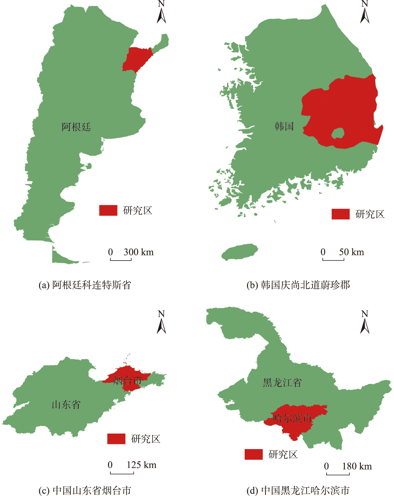
表2 Landsat-8遥感影像数据信息Tab. 2 Landsat-8 remote sensing image data information |
| 时间 | 中心位置 | Path/Row | 幅数/幅 |
|---|---|---|---|
| 2022.1.07—2022.3.12 | 阿根廷科连特斯 | 225/80 | 5 |
| 2022.3.03—2022.4.20 | 韩国蔚珍郡 | 114/34 | 4 |
| 2022.2.25—2022.4.14 2023.3.25—2023.4.10 | 中国山东省烟台市 中国黑龙江省哈尔滨市 | 120/34 119/28 | 4 2 |
表3 地表反射率数据集的波段范围Tab. 3 The band range of the surface reflectance database |
| 波段 | Landsat-8/nm | MOD09GA/nm |
|---|---|---|
| Blue | 450~510 | 459~479 |
| Green | 530~590 | 545~565 |
| Red | 640~670 | 620~670 |
| NIR | 850~880 | 841~876 |
| SWIR | 1 570~1 650 | 1 628~1 652 |
表4 不同规模下的火烧迹地误差结果Tab. 4 Error results of fire burnt ground at different scales (%) |
| 地点 | OE | CE |
|---|---|---|
| 韩国 | 17.83 | 22.30 |
| 阿根廷 | 21.45 | 19.12 |
| 山东烟台 | 3.25 | 2.17 |
| 黑龙江省哈尔滨 | 15.30 | 11.61 |
表5 不同方法火烧迹地识别精度Tab. 5 Different methods of burned area recognitionaccuracy (%) |
| 方法 | Precision | OA |
|---|---|---|
| 指数法 | 72.11 | 84.12 |
| 随机森林 | 73.35 | 86.07 |
| 先验地表反射率数据集 | 74.49 | 84.43 |
| [1] |
舒立福, 田晓瑞, 李红. 世界森林火灾状况综述[J]. 世界林业研究, 1998, 11(6):41-47.
[
|
| [2] |
|
| [3] |
|
| [4] |
|
| [5] |
|
| [6] |
|
| [7] |
|
| [8] |
|
| [9] |
|
| [10] |
|
| [11] |
|
| [12] |
|
| [13] |
|
| [14] |
|
| [15] |
|
| [16] |
|
| [17] |
|
| [18] |
|
| [19] |
|
| [20] |
|
| [21] |
肖潇, 冯险峰, 孙庆龄. 利用MODIS影像提取火烧迹地方法的研究[J]. 地球信息科学学报, 2016, 18(11):1529-1536.
[
|
| [22] |
尤慧, 刘荣高, 祝善友. 加拿大北方森林火烧迹地遥感分析[J]. 地球信息科学学报, 2013, 15(4):597-603.
[
|
| [23] |
|
| [24] |
|
| [25] |
|
| [26] |
|
| [27] |
徐英德, 裴久渤, 李双异, 等. 东北黑土地不同类型区主要特征及保护利用对策[J]. 土壤通报, 2023, 54(2):495-504.
[
|
| [28] |
李保国, 刘忠, 黄峰, 等. 巩固黑土地粮仓保障国家粮食安全[J]. 中国科学院院刊, 2021, 36(10):1184-1193.
[
|
/
| 〈 |
|
〉 |


