
融合VGI和遥感等多源数据的洪涝范围提取与模拟方法
|
邢子瑶(1994— ),女,河北石家庄人,博士生,主要从事灾害信息挖掘与分析。E-mail: xingziyao@cau.edu.cn |
收稿日期: 2022-12-11
修回日期: 2023-03-20
网络出版日期: 2023-09-05
基金资助
国家重点研发计划项目(2018YFC1508901-3)
Flood Inundation Mapping and Estimation using VGI, Remote Sensing Images and Other Multi-source Data
Received date: 2022-12-11
Revised date: 2023-03-20
Online published: 2023-09-05
Supported by
National Key R&D Program of China(2018YFC1508901-3)
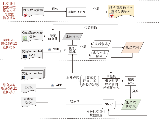
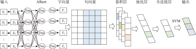
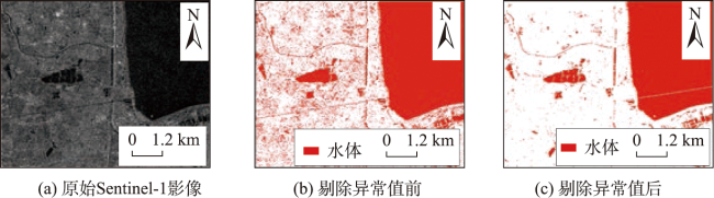
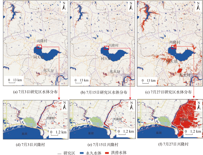
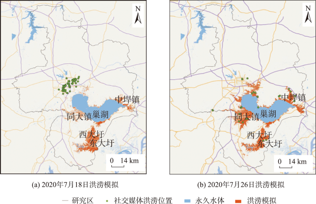
及时准确的洪涝范围提取可以提高应急管理部门对于洪涝灾害的响应能力,减轻灾害影响。SAR遥感不受云雨影响,是洪涝灾害监测的有效工具。然而,由于卫星重返周期的限制,基于SAR的洪涝连续观测较难实现。在应急背景下,如何快速、实时进行洪涝范围提取是急需解决的问题。本文提出了一种结合遥感、VGI等多源数据的洪涝范围提取与模拟方法: ① 构建Albert+CNN的文本分类模型提取社交媒体洪涝信息;② 基于异常值剔除方法利用社交媒体和OSM等VGI数据代替人工采样对Sentinel-1 SAR数据进行分类,提取洪涝范围;③ 结合社交媒体、水位数据等多源数据基于SNIC分割和成本距离等方法模拟无可用SAR数据时的洪涝淹没情况,提高洪涝的淹没范围提取频次。研究表明,本文基于Albert+CNN与异常值剔除的样本自动生成方法,可以有效辅助SAR数据的洪涝分类;利用VGI数据结合水情、DEM等多源数据进行了洪涝范围的模拟可以增加洪涝监测的时间分辨率。本研究有助于提高洪涝信息提取能力,为VGI支持洪涝灾害的应急管理提供参考。
邢子瑶 , 董芯蕊 , 昝糈莉 , 杨帅 , 黄梓焓 , 刘哲 , 张晓东 . 融合VGI和遥感等多源数据的洪涝范围提取与模拟方法[J]. 地球信息科学学报, 2023 , 25(9) : 1869 -1881 . DOI: 10.12082/dqxxkx.2023.220966
Timely and accurate flood extraction can improve the ability of emergency management departments to respond to flood disasters and thus reduce the impact of disasters. Synthetic Aperture Radar (SAR) remote sensing is not affected by cloud and rain and acts as an effective tool for flood disaster monitoring. However, rapid and automated sample acquisition for accurately obtaining flood information still poses challenges in the post-disaster emergency stage. In addition, due to the satellite’s limited revisit period, flood extent extraction based on remote sensing images has a certain time gap. Therefore, how to delineate flood extent in real time is an urgent problem to be solved. In this paper, combining SAR images, Volunteered Geographic Information (VGI), and other multi-source data, an automated flood inundation mapping and estimation method is proposed to identify the flood in a nearly real-time way. Firstly, the Albert+CNN text classification model is constructed to extract flood information from social media. Secondly, based on the outlier elimination method, the Sentinel-1 SAR data are classified using VGI data such as social media and OSM instead of manual sampling, and the flood extent is extracted. Thirdly, in combination with social media, water level data, and other multi-source data, the flood inundation without SAR data is simulated based on SNIC segmentation and cost distance methods. The results show that the text classification model based on Albert+CNN model constructed in this paper can accurately classify the flood information of social media, with the classification accuracy up to 83.6%. The automatic sample generation method based on outlier elimination can effectively assist flood classification from SAR data. The accuracy of flood classification using the generated samples and random forest is 92.7%, which is more than 10% higher than that of the OSTU-based methods. Using VGI data and multi-source data such as water situation and DEM to simulate the flood extent can further increase the temporal resolution of flood monitoring. In this study area, two periods of flood simulation results are provided during the flood process, improving the flood disaster information. This study is helpful to improve the efficiency of flood information extraction and provide reference for VGI to support the emergency management of flood disasters. In the future, the picture information in VGI data can be comprehensively used to extract flood depth and hydrological models could also be used to further improve the flood situation awareness and prediction ability.
表1 特征说明及其计算方法Tab. 1 Characteristics description and its calculation method |
表2 Albert+CNN分类精度Tab. 2 model classification accuracy |
| 类别 | 精确率 | 召回率 | F1-score |
|---|---|---|---|
| 非洪涝 | 0.812 | 0.810 | 0.810 |
| 洪涝 | 0.860 | 0.856 | 0.849 |
| 平均值 | 0.836 | 0.833 | 0.830 |
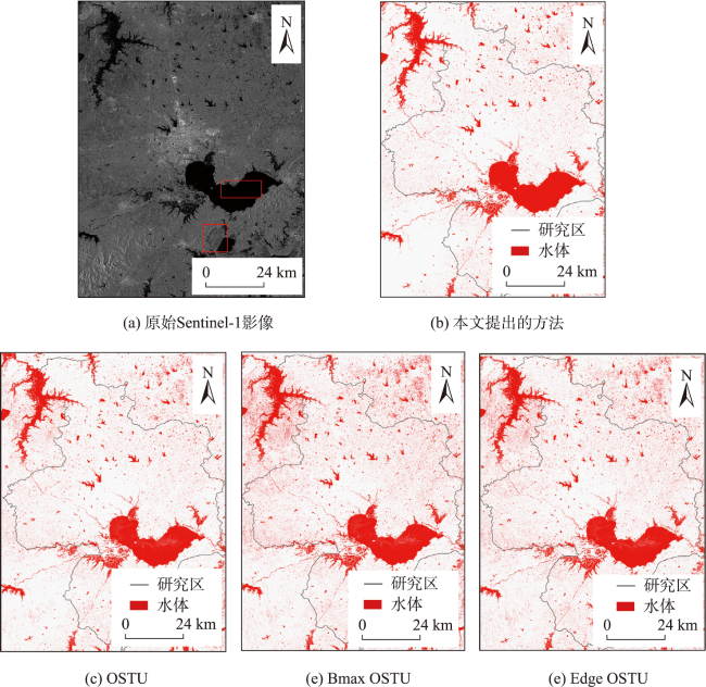
表3 基于SAR的洪涝范围提取精度对比Tab. 3 classification accuracy comparison (%) |
| 方法 | 类别 | 用户精度 | 生产者精度 | 总体精度 |
|---|---|---|---|---|
| 本方法 | 非洪涝 | 88.1 | 98.85 | 92.7 |
| 洪涝 | 98.6 | 86.6 | ||
| OSTU | 非洪涝 | 72.1 | 91.6 | 78.1 |
| 洪涝 | 88.5 | 64.6 | ||
| Bmax-OSTU | 非洪涝 | 96.2 | 68.3 | 78.5 |
| 洪涝 | 64.3 | 95.5 | ||
| Edge-OSTU | 非洪涝 | 96.2 | 72.2 | 81.8 |
| 洪涝 | 70.3 | 95.9 |
表4 洪涝模拟结果精度验证Tab.4 classification accuracy of flood inundation estimation (%) |
| 类别 | 用户精度 | 生产者精度 | 总体精度 |
|---|---|---|---|
| 非洪涝 | 87.6 | 93.8 | 86.7 |
| 洪涝 | 84.4 | 71.4 |
| [1] |
|
| [2] |
裴志远, 杨邦杰. 应用NOAA图像进行大范围洪涝灾害遥感监测的研究[J]. 农业工程学报, 1999, 15(4):203-206.
[
|
| [3] |
|
| [4] |
|
| [5] |
|
| [6] |
|
| [7] |
郭玮, 袁宏永, 薛明, 等. SAR影像洪水淹没范围深度学习提取方法[J]. 中国安全科学学报, 2022, 32(4):177-184.
[
|
| [8] |
|
| [9] |
|
| [10] |
段伟芳, 温小乐, 徐涵秋, 等. 基于光学与雷达影像变化检测的2020年鄱阳湖洪灾评估与分析[J]. 地球信息科学学报, 2022, 24(12):2435-2447.
[
|
| [11] |
吕素娜, 薛思涵, 谢婷, 等. 哨兵一号SAR数据在鄱阳湖洪涝灾害监测中的应用[J]. 卫星应用, 2021(8):51-55.
[
|
| [12] |
|
| [13] |
|
| [14] |
|
| [15] |
周峰, 许有鹏, 石怡. 基于AHP-OWA方法的洪涝灾害风险区划研究——以秦淮河中下游地区为例[J]. 自然灾害学报, 2012, 21(6):83-90.
[
|
| [16] |
|
| [17] |
|
| [18] |
|
| [19] |
|
| [20] |
郑承宇, 王新, 王婷, 等. 基于ALBERT-TextCNN模型的多标签医疗文本分类方法[J]. 山东大学学报(理学版), 2022, 57(4):21-29.
[
|
| [21] |
|
| [22] |
|
| [23] |
|
| [24] |
|
| [25] |
|
| [26] |
| [27] |
|
| [28] |
|
| [29] |
|
| [30] |
|
| [31] |
|
| [32] |
|
| [33] |
|
| [34] |
|
| [35] |
|
| [36] |
|
/
| 〈 |
|
〉 |