
基于去除土壤散射干扰SAR数据的玉米残茬生物量反演
|
谢小曼(1998—),女,海南儋州人,硕士生,研究方向为空间信息技术。E-mail: xxmh9657@163.com |
收稿日期: 2022-10-11
修回日期: 2023-01-09
网络出版日期: 2023-09-22
基金资助
国家自然科学基金项目(42171324)
中国科学院地理所技术服务项目(202205511910797)
Retrieval of Corn Residue Biomass Based on SAR Data with Soil Scattering Interference Removed
Received date: 2022-10-11
Revised date: 2023-01-09
Online published: 2023-09-22
Supported by
National Natural Science Foundation of China(42171324)
Technical Service Project from Institute of Geographic Sciences and Natural Resources Research Chinese Academy of Sciences(202205511910797)
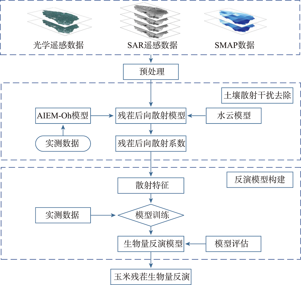
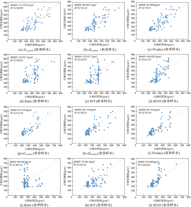
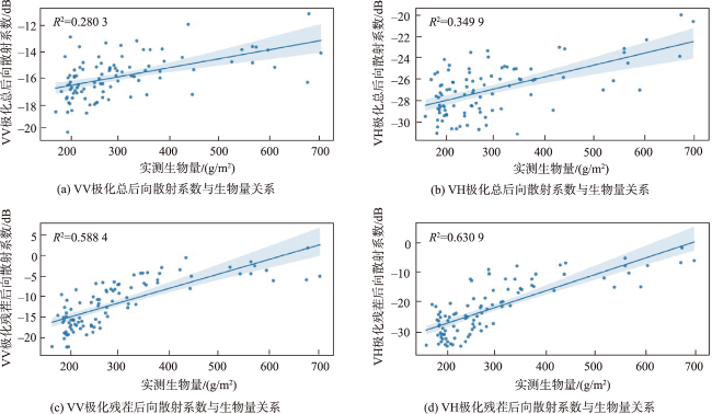
作为保护性耕作的主要方式之一,作物留茬对农田生态系统的物质和能量循环有重要影响。及时、准确地获取作物残茬生物量分布状况对定量了解保护性耕作实施状况、评估残茬影响具有重要意义。本文利用AIEM-Oh模型和水云模型(Water Cloud Model,WCM)构建残茬后向散射模型,分离出去除土壤散射影响后玉米残茬后向散射系数;在此基础上选择适宜的雷达指数特征构建玉米残茬生物量反演模型,以Sentinel-1 SAR数据为主数据源,以梨树县为研究区实现其玉米残茬生物量估算。结果表明:基于残茬后向散射模型可以有效地消除土壤后向散射的干扰,选择合适特征参数构建的反演模型能够获得较好的残茬生物量反演效果。其中,基于双极化散射积(Product)的秋季生物量反演精度R2大于0.75,RMSE达85 g/m2以下。与去除土壤散射干扰前的生物量反演模型相比,去除土壤散射干扰后,采用常见指数特征的生物量反演精度R2增加至少0.15,RMSE减少至少17 g/m2。本研究验证了利用去除土壤散射干扰后残茬后向散射数据进行残茬生物量反演的可行性,为今后利用SAR遥感数据进行玉米残茬生物量的动态监测提供了有益的尝试。
关键词: Sentinel-1 SAR; 生物量反演; 玉米残茬; 残茬后向散射模型
谢小曼 , 洪梓翔 , 李俐 , 仇冰琦 , 苏怡然 . 基于去除土壤散射干扰SAR数据的玉米残茬生物量反演[J]. 地球信息科学学报, 2023 , 25(10) : 2070 -2083 . DOI: 10.12082/dqxxkx.2023.220777
As a main way of conservation tillage, crop residue has important influence on the cycle of material and energy in farmland ecosystem. Acquisition of the biomass information of corn residues timely and accurately is of great significance for understanding the implementation of conservation tillage and evaluating the impact of residues quantitatively. However,compared with crops, residues have lower coverage and contain less water,which makes it more difficult to acquire the biomass. To address this issue, we developed a residue backscattering model based on AIEM-Oh model and the Water Cloud Model (WCM) to remove the soil scattering interference. Using Sentinel-1 SAR images as the main data source, a regression model of corn residue biomass was constructed based on radar features selected to retrieve and map the corn residue biomass in Lishu County. Results show that the residue backscattering model can eliminate the interference of soil backscattering contribution effectively, and the inversion model based on the residue backscattering coefficient can improve the biomass inversion accuracy. The autumn biomass inversion model based on the dual-polarized scattering product (Product) has an R2 greater than 0.75, and an RMSE less than 85 g/m2, showing an increase of at least 0.12 in R2 and a decrease of 17 g/m2 in RMSE compared to the biomass inversion model before soil scattering contribution removed. This study verifies the feasibility of residue biomass inversion model based on backscattering data with soil scattering interference removed, and provides an attempt for the dynamic monitoring of corn residue biomass using SAR remote sensing data in the future.
表1 AIEM-Oh模型参数取值范围Tab. 1 AIEM-Oh model parameter value range |
| 参数 | 最小值 | 最大值 | 步进 |
|---|---|---|---|
| 入射角/° | 25 | 55 | 2 |
| 土壤体积含水量/% | 2 | 50 | 2 |
| 均方根高度/cm | 0.2 | 3 | 0.2 |
| 相关长度/cm | 4 | 50 | 2 |
表2 研究区主要作物物候期Tab. 2 Phenological period of main crops in the study area |
| 4月 | 5月 | 6月 | 7月 | 8月 | 9月 | 10月 | |||||||
|---|---|---|---|---|---|---|---|---|---|---|---|---|---|
| 上旬 中旬 下旬 | 上旬 中旬 下旬 | 上旬 中旬 下旬 | 上旬 中旬 下旬 | 上旬 中旬 下旬 | 上旬 中旬 下旬 | 上旬 中旬 下旬 | |||||||
| 水稻 | 播种、出苗 | 抽穗 | 成熟期 | ||||||||||
| 玉米 | 播种、出苗 | 抽穗 | 成熟期 | ||||||||||
| 大豆 | 播种、出苗 | 抽穗 | 成熟期 |
表3 获取影像类型及时间Tab. 3 Type and time of remote sensing imagery obtained |
| 时期 | 数据类型 | 影像时间 |
|---|---|---|
| 秋季 | S-1 Level-1 GRD | 2020年11月03日 |
| S-2 Level-1C | 2020年11月09日 | |
| SMAP/Sentinel-1 Leve2级 | 2020年11月03日 | |
| 春季 | S-1 Level-1 GRD | 2021年04月08日 |
| S-2 Level-1C | 2021年04月18日 | |
| SMAP/Sentinel-1 Leve2级 | 2021年04月08日 |
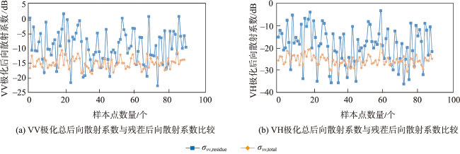
表4 去除土壤散射干扰前后的后向散射系数变化统计Tab. 4 Statistical table of backscattering coefficient changes before and after removal of soil scattering interference (dB) |
| 极化方式 | 最大值 | 最小值 | 均值 |
|---|---|---|---|
| VV | 12.469 | 0.0474 | 6.089 |
| VH | 18.214 | 0.19 | 8.416 |
表5 不同特征残茬生物量反演性能(去除土壤散射干扰前)Tab. 5 Performance of different features on biomass inversion (before the removal of soil scattering interference) |
| 反演特征 | 2020年秋季样本 (n=81) | 2021年春季样本 (n=94) | |||
|---|---|---|---|---|---|
| R2 | RMSE/(g/m2) | R2 | RMSE/(g/m2) | ||
| 0.503 05 | 119.179 1 | 0.489 03 | 90.756 5 | ||
| 0.338 38 | 137.600 8 | 0.322 47 | 82.587 7 | ||
| Product | 0.575 46 | 107.416 1 | 0.505 21 | 70.088 1 | |
| Ratio | 0.179 61 | 147.443 5 | 0.145 56 | 121.008 3 | |
| RVI | 0.140 37 | 156.845 6 | 0.169 93 | 94.537 2 | |
| SPAN | 0.415 23 | 129.363 2 | 0.338 81 | 134.683 7 | |
表6 去除土壤散射干扰后不同特征生物量反演精度变化Tab. 6 Changes of biomass inversion accuracy of different features after separating soil scattering contribution |
| 反演特征 | 2020年秋季样本 (n=81) | 2021年春季样本 (n=94) | |||
|---|---|---|---|---|---|
| ΔR2 | ΔRMSE/(g/m2) | ΔR2 | ΔRMSE/(g/m2) | ||
| 0.221 13 | 30.334 6 | 0.213 48 | 42.639 6 | ||
| 0.220 52 | 25.247 9 | 0.191 23 | 21.067 8 | ||
| Product | 0.183 25 | 24.318 1 | 0.214 18 | 23.355 5 | |
| Ratio | 0.203 01 | 14.522 2 | 0.239 60 | 30.622 3 | |
| RVI | 0.214 10 | 20.927 9 | 0.155 41 | 22.075 8 | |
| SPAN | 0.200 10 | 24.442 9 | 0.271 84 | 79.636 8 | |
注:ΔR2、ΔRMSE(g/m2)分别为去除土壤散射干扰前后模型精度差值的绝对值。 |
| [1] |
|
| [2] |
蔡文婷, 赵书河, 王亚梅, 等. 结合Sentinel-2光谱与纹理信息的冬小麦作物茬覆盖度估算[J]. 遥感学报, 2020, 24(9):1108-1119.
[
|
| [3] |
|
| [4] |
雷步云. 基于全极化雷达数据的冬小麦作物残茬生物量估算研究[D]. 南京: 南京大学, 2015.
[
|
| [5] |
|
| [6] |
|
| [7] |
|
| [8] |
|
| [9] |
|
| [10] |
|
| [11] |
|
| [12] |
|
| [13] |
孔庆玲, 李俐, 徐凯华, 等. 基于Sentinel-1A的东北地区作物留茬区监测研究[J]. 农业机械学报, 2017, 48(S1):284-289.
[
|
| [14] |
|
| [15] |
|
| [16] |
|
| [17] |
|
| [18] |
|
| [19] |
|
| [20] |
|
| [21] |
|
| [22] |
|
| [23] |
|
| [24] |
|
| [25] |
耿德源, 赵天杰, 施建成, 等. 地基雷达的微波面散射模型对比与土壤水分反演[J]. 遥感学报, 2021, 25(4):929-940.
[
|
| [26] |
|
| [27] |
|
| [28] |
赵建辉, 张晨阳, 闵林, 等. 基于特征选择和GA-BP神经网络的多源遥感农田土壤水分反演[J]. 农业工程学报, 2021, 37(11):112-120.
[
|
| [29] |
裴浩杰, 冯海宽, 李长春, 等. 基于综合指标的冬小麦长势无人机遥感监测[J]. 农业工程学报, 2017, 33(20):74-82.
[
|
| [30] |
|
| [31] |
陈安旭, 李月臣. 基于Sentinel-2影像的西南山区不同生长期水稻识别[J]. 农业工程学报, 2020, 36(7):192-199.
[
|
| [32] |
|
| [33] |
李俐, 王荻, 王鹏新, 等. 基于色彩运算和混沌粒子群滤波的土壤粗糙度测算[J]. 农业机械学报, 2015, 46(3):158-165.
[
|
| [34] |
|
| [35] |
|
| [36] |
刘之榆, 刘忠, 万炜, 等. SAR与光学遥感影像的玉米秸秆覆盖度估算[J]. 遥感学报, 2021, 25(6):1308-1323.
[
|
/
| 〈 |
|
〉 |
