
多结构要素六边形全球离散格网系统构建方法及应用
|
周建彬(1995—),男,安徽黄山人,博士生,主要从事全球离散格网、空间影像信息研究。E-mail: zhoudggs0901@139.com |
收稿日期: 2022-12-04
修回日期: 2023-03-01
网络出版日期: 2023-11-02
基金资助
国防科技创新特区项目(20-163-14-LZ-001-003-01)
Construction Methods and Applications of a Hexagonal Discrete Global Grid System Considering Multiple Structural Elements
Received date: 2022-12-04
Revised date: 2023-03-01
Online published: 2023-11-02
Supported by
National Defense Science Innovation Special Zone Program(20-163-14-LZ-001-003-01)
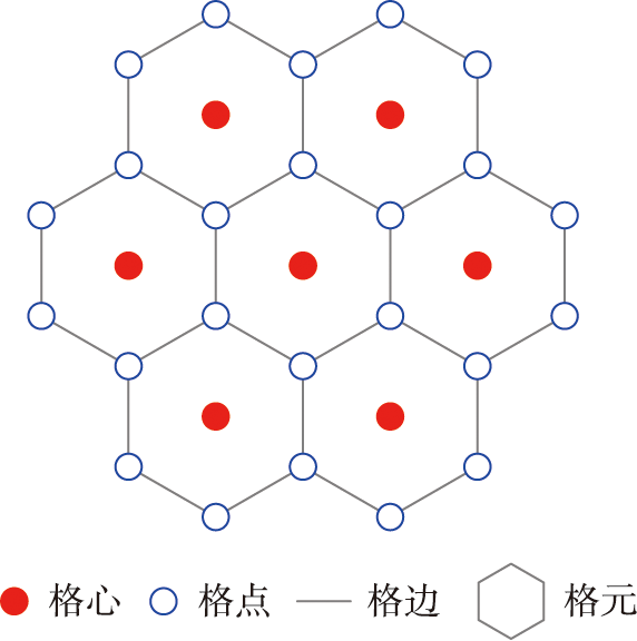
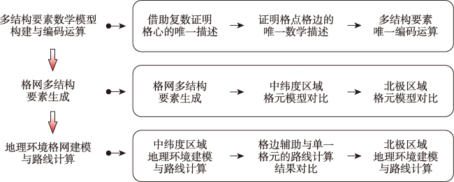
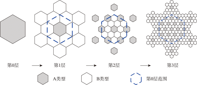
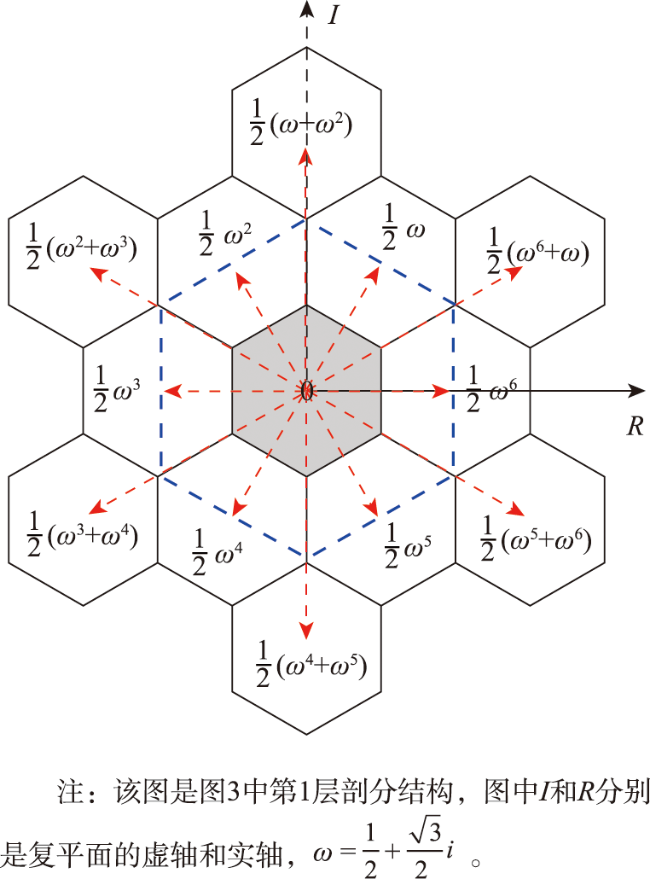
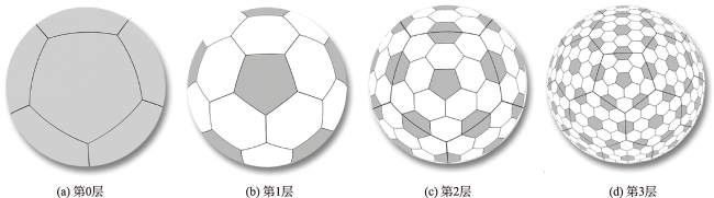
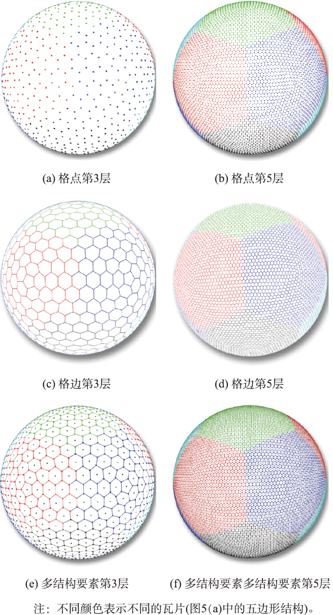
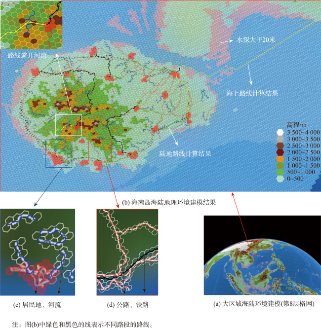
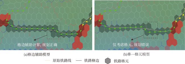
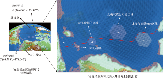
格网是地理环境数字化离散的数据组织模型。局部投影的平面格网存在适用范围受限、全球扩展困难和单元变形严重等缺陷,而新型多面体全球离散格网大多只关注单元中心,忽视了单元顶点和边的作用,功能囿于数据建模与表达,难以适用于位置相关事件计算。本文首先建立四孔六边形全球离散格网“格心-格点-格边”多结构要素数学模型,推导证明多结构要素的唯一数学描述。然后,依据该数学模型提出格点、格边关联格心的编码运算法则。最后,设计地理环境格网建模和路线计算应用案例证明本文方法的可行性和优越性。结果表明,相较于投影平面格网,六边形全球离散格网的格元变形更小、变形离散程度更小:六边形格元面积、周长和角度形变误差率均小于7.5%,中低纬度区域兰伯特等角圆锥投影格网部分单元面积和周长形变误差率超过10%,高纬度区域墨卡托投影格网面积和周长形变误差率超过60%;相较于单一格元模型,多结构要素能够按事件计算需求准确表达环境信息,更有利于准确计算事件结果。
周建彬 , 贲进 , 丁俊杰 , 黄心海 , 梁启爽 , 何天国 . 多结构要素六边形全球离散格网系统构建方法及应用[J]. 地球信息科学学报, 2023 , 25(11) : 2107 -2119 . DOI: 10.12082/dqxxkx.2023.220952
Grid is a data organization model for geographic environment digitization. Utilizing a grid model to model geographic environment is a basis for deducing, analyzing, and deciding important events from a global perspective. Traditional local projection-based grids have disadvantages including small range, limitation in gloal extrapolation, and large grid deformation. Most of existing new spherical grid models, namely Discrete Global Grid Systems (DGGS), only focus on the grid centers, ignoring roles of grid vertexs and edges. Therefore, the existing functions of DGGSs are limited to data modeling and are challenging in the caculation of location-based events. Herein, a unique description model for multi-structural elements (i.e. center, vertex, edge of a cell) of a hexagonal DGGS is established mathematically, and the coding and operation methods are designed accordingly. Then, geographic environment modeling with DGGS and route caculation experiments are designed to demonstrate the feasibility and superiority of our methods. The results show that the hexagonal DGGS proposed in this study has the advantages of small grid deformation and concentrated deformation distribution compared with the projection-based plane grids. The error rate of area, perimeter, and angle deformation of hexagonal grids is less than 7.5%, the error rate of area and perimeter deformation of Lambert Conformal Conic projection grids is more than 10% in mid and low latitude region, and the error rate of Mercator projection grids is more than 60% in high latitude region. Compared with the single cell model, multi structure elements can accurately express environmental information according to the event caculation requirements, which is more conducive to calculation of event results accurately. The methods proposed in this study have good application prospects in the field of geographic environment modeling and event caculation in a wide range and across the global scale.
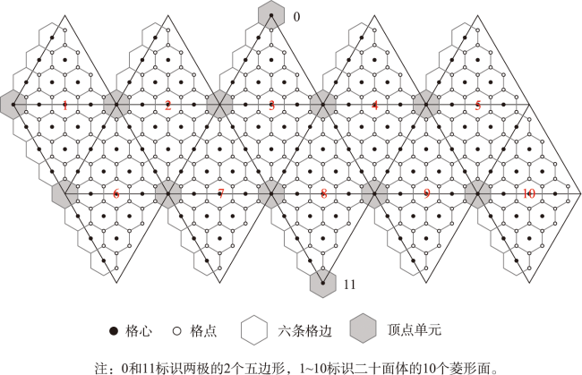
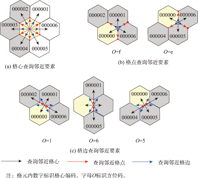
| 规则1 多结构要素编码规则 |
|---|
| 第1位(R)作为保留位,以0标识。 |
| 第2位(O)标识结构要素在单元中的方位,0标识格心,f,e标识格点,1,6,5标识格边。 |
| 第3位(E)标识结构要素类型,0标识格心,1标识格点,2标识格边。 |
| 第4位(T)标识初始单元(第0层),T=0~b(16进制)。 |
| 第5位至第32位(C1C2LC28)标识后续层次格心,共计28层,其中Ci∈C(i=1~28)。 |
表1 中低纬度各误差率区间的格元个数统计结果Tab. 1 Number of cells in each error rate interval in the middle and low latitudes (个) |
| 格网层次 | 8 | |||||
|---|---|---|---|---|---|---|
| 误差率 /% | LCC投影格网 | 六边形全球离散格网 | ||||
| 面积 | 周长 | 角度 | 面积 | 周长 | 角度 | |
| >5 | 0 | 0 | 0 | 0 | 0 | 0 |
| 2.5~5 | 2 290 | 0 | 0 | 0 | 0 | 0 |
| 0~2.5 | 3 772 | 6 062 | 17 | 0 | 0 | 194 |
| -2.5~0 | 1 217 | 2 176 | 13 425 | 0 | 6 268 | 12 505 |
| -5~-2.5 | 975 | 1 559 | 0 | 0 | 6 431 | 0 |
| -7.5~-5 | 847 | 1 316 | 0 | 12 699 | 0 | 0 |
| -10~-7.5 | 775 | 1 173 | 0 | 0 | 0 | 0 |
| <-10 | 3 566 | 1 156 | 0 | 0 | 0 | 0 |
| 格网层次 | 9 | |||||
| 误差率 /% | LCC投影格网 | 六边形全球离散格网 | ||||
| 面积 | 周长 | 角度 | 面积 | 周长 | 角度 | |
| >5 | 0 | 0 | 0 | 0 | 0 | 0 |
| 2.5~5 | 9 167 | 0 | 0 | 0 | 0 | 0 |
| 0~2.5 | 15 028 | 24 195 | 17 | 0 | 0 | 194 |
| -2.5~0 | 4 874 | 8 695 | 13 425 | 0 | 24 875 | 12 505 |
| -5~-2.5 | 3 912 | 6 251 | 0 | 0 | 25 403 | 0 |
| -7.5~-5 | 3 390 | 5 257 | 0 | 50 278 | 0 | 0 |
| -10~-7.5 | 3 071 | 4 688 | 0 | 0 | 0 | 0 |
| <-10 | 14 326 | 4 682 | 0 | 0 | 0 | 0 |
| 格网层次 | 10 | |||||
| 误差率/% | LCC投影格网 | 六边形全球离散格网 | ||||
| 面积 | 周长 | 角度 | 面积 | 周长 | 角度 | |
| >5 | 0 | 0 | 0 | 0 | 0 | 0 |
| 2.5~5 | 36 535 | 0 | 0 | 0 | 0 | 0 |
| 0~2.5 | 59 899 | 96 434 | 1 084 | 0 | 0 | 2351 |
| -2.5~0 | 19 457 | 34 660 | 213 416 | 0 | 99 295 | 197 669 |
| -5~-2.5 | 15 563 | 24 967 | 0 | 0 | 100 725 | 0 |
| -7.5~-5 | 13 530 | 20 977 | 0 | 200 020 | 0 | 0 |
| -10~-7.5 | 12 260 | 18 713 | 0 | 0 | 0 | 0 |
| <-10 | 57 256 | 18 749 | 0 | 0 | 0 | 0 |
表2 北极区域各误差率区间的格元个数统计结果Tab. 2 Statistics on the number of cells in each error rate interval in the arctic region (个) |
| 格网层次 | 8 | 9 | 10 | |||||||||||||||
|---|---|---|---|---|---|---|---|---|---|---|---|---|---|---|---|---|---|---|
| 误差率/% | 墨卡托投影格网 | 六边形全球离散格网 | 墨卡托投影格网 | 六边形全球离散格网 | 墨卡托投影格网 | 六边形全球离散格网 | ||||||||||||
| 面积 | 周长 | 角度 | 面积 | 周长 | 角度 | 面积 | 周长 | 角度 | 面积 | 周长 | 角度 | 面积 | 周长 | 角度 | 面积 | 周长 | 角度 | |
| >5 | 0 | 0 | 0 | 0 | 0 | 0 | 0 | 0 | 0 | 0 | 0 | 0 | 0 | 0 | 0 | 0 | 0 | 0 |
| 2.5~5 | 0 | 0 | 0 | 0 | 0 | 0 | 0 | 0 | 0 | 0 | 0 | 0 | 0 | 0 | 0 | 0 | 0 | 0 |
| 0~2.5 | 0 | 0 | 0 | 0 | 0 | 65 | 0 | 0 | 0 | 0 | 0 | 214 | 0 | 0 | 0 | 0 | 0 | 676 |
| -2.5~0 | 0 | 0 | 0 | 0 | 1 208 | 3 161 | 0 | 0 | 0 | 0 | 4 816 | 12 433 | 0 | 0 | 0 | 0 | 19 322 | 49 368 |
| -5~-2.5 | 1 005 | 1 005 | 0 | 0 | 2 018 | 0 | 3 990 | 3 990 | 0 | 0 | 7 831 | 0 | 16 165 | 16 165 | 0 | 0 | 30 722 | 0 |
| -7.5~-5 | 1 809 | 1 809 | 0 | 3 226 | 0 | 0 | 7 182 | 7 182 | 0 | 12 647 | 0 | 0 | 28 355 | 28 355 | 0 | 50 044 | 0 | 0 |
| -10~-7.5 | 670 | 670 | 0 | 0 | 0 | 0 | 2 527 | 2 527 | 0 | 0 | 0 | 0 | 9 805 | 9 805 | 0 | 0 | 0 | 0 |
| <-10 | 0 | 0 | 0 | 0 | 0 | 0 | 0 | 0 | 0 | 0 | 0 | 0 | 0 | 0 | 0 | 0 | 0 | 0 |
| [1] |
李锋, 万刚, 蒋秉川, 等. 虚拟地理环境时空建模及其作战计划推演应用[J]. 测绘学报, 2018, 47(8):1072-1079.
[
|
| [2] |
王晨昊. 地理环境建模关键技术研究[D]. 长沙: 国防科学技术大学, 2005.
[
|
| [3] |
周成虎, 欧阳, 马廷. 地理格网模型研究进展[J]. 地理科学进展, 2009, 28(5):657-662.
[
|
| [4] |
陈庆秋. 虚拟战场环境设计与实现[D]. 沈阳: 东北大学, 2011.
[
|
| [5] |
吴立新, 余接情. 基于球体退化八叉树的全球三维网格与变形特征[J]. 地理与地理信息科学, 2009, 25(1):1-4.
[
|
| [6] |
赵学胜, 贲进, 孙文彬, 等. 地球剖分格网研究进展综述[J]. 测绘学报, 2016, 45(S1):1-14.
|
| [7] |
陈艺航, 王金鑫, 曹泽宁, 等. 全球离散格网系统结构要素一体化编码与生成方法[J]. 地球信息科学学报, 2021, 23(8):1382-1390.
[
|
| [8] |
张继凯. 多维战场环境态势可视化关键技术研究[D]. 秦皇岛: 燕山大学, 2016.
[
|
| [9] |
吴婷婷, 吴琳, 沈弼龙. 基于H3空间索引的兵棋战场环境建模与应用探析[J]. 指挥控制与仿真, 2021, 43(5):14-21.
|
| [10] |
周慧君. 基于六边形离散格网的全球洋流场特征提取方法[D]. 南京: 南京师范大学, 2021.
[
|
| [11] |
|
| [12] |
|
| [13] |
李新星, 李建成, 刘晓刚, 等. 球谐旋转变换结合非全次Legendre方法的局部六边形网格重力场球谐综合[J]. 地球物理学报, 2021, 64(11):3933-3947.
|
| [14] |
余接情, 石珍, 吴立新, 等. 基于SDOG-ESSG的地球系统元胞自动机框架及其应用试验[J]. 测绘学报, 2016, 45(S1):40-47.
|
| [15] |
朱思坤, 赵学胜. 基于球面退化四叉树格网的GlobeLand30数据表达及精度分析[J]. 地理信息世界, 2017, 24(4):53-57.
|
| [16] |
Global Grid Systems. https://www.globalgridsystems.com,2019.
|
| [17] |
|
| [18] |
|
| [19] |
高俊, 曹雪峰. 空间认知推动地图学学科发展的新方向[J]. 测绘学报, 2021, 50(6):711-725.
[
|
| [20] |
赵龙, 李国庆, 姚晓闯, 等. 正二十面体六边形全球离散格网编码运算[J]. 地球信息科学学报, 2023, 25(2):239-251.
[
|
| [21] |
肖坤, 艾廷华, 王璐. 正六边形格网DEM下的等高线生成算法及质量评价[J]. 地球信息科学学报, 2022, 24(4):643-656.
|
| [22] |
周建彬, 贲进, 王蕊, 等. 四孔六边形全球离散格网一致瓦片层次结构编码运算[J]. 武汉大学学报·信息科学版: 2021,1-12.
[
|
| [23] |
贲进, 李亚路, 周成虎, 等. 三孔六边形全球离散格网系统代数编码方法[J]. 中国科学:地球科学, 2018, 48(3):340-352.
|
| [24] |
何昌其. 桌面战争:美国兵棋发展应用及案例研究[M]. 北京: 航空工业出版社, 2017.
[
|
| [25] |
|
| [26] |
张欣, 张寅宝, 李坤伟. 兵棋地图概念框架研究[J]. 地理空间信息, 2017, 15(8):5-7,9.
|
| [27] |
孙文彬, 周长江. 一种近似等积球面菱形格网的构建方法[J]. 武汉大学学报·信息科学版, 2016, 41(8):1040-1045.
|
| [28] |
GlobalGrid-30s, ESRI, 10.6084/m9.figshare.20417829, 2022.
|
| [29] |
国家基础地理数据, https://www.webmap.cn/store.do?method=store&storeId=2,2015.
[National Geomatics data of China, https://www.webmap.cn/store.do?method=store&storeId=2,2015. ]
|
| [30] |
周建彬, 贲进, 黄心海, 等. 广域六角格兵棋地图构建方法与机动推演应用[J]. 系统工程与电子技术, 2023, 45(3):769-776.
[
|
| [31] |
|
| [32] |
吕宝刚. 北极航行的环境因素及冰区航行安全措施研究[D]. 大连: 大连海事大学, 2012.
[
|
| [33] |
李树军, 张哲, 李惠雯, 等. 编制北极地区航海图有关问题的探讨[J]. 海洋测绘, 2012, 32(1):58-60.
|
| [34] |
彭认灿, 董箭, 王芳, 等. 日晷投影和等距离正圆柱投影在极区航海图编制及航海应用中的比较[J]. 测绘地理信息, 2022, 47(1):19-23.
|
/
| 〈 |
|
〉 |

