
顾及空间分布的改进薄板样条矢量数据几何精度降低方法
|
王敏璇(2002— ),女,江苏镇江人,本科生,研究方向为地理数据安全。E-mail: wangminxuan116@163.com |
收稿日期: 2023-04-19
修回日期: 2023-06-05
网络出版日期: 2023-11-02
基金资助
国家自然科学基金项目(42071362)
国家自然科学基金项目(41971338)
国家重点研发计划项目(2022YFC3803600)
A Vector Data Geometric Accuracy Reduction Method Considering Spatial Distribution Based on the Improved Thin Plate Spline Model
Received date: 2023-04-19
Revised date: 2023-06-05
Online published: 2023-11-02
Supported by
National Natural Science Foundation of China(42071362)
National Natural Science Foundation of China(41971338)
National Key Research and Development Program of China(2022YFC3803600)
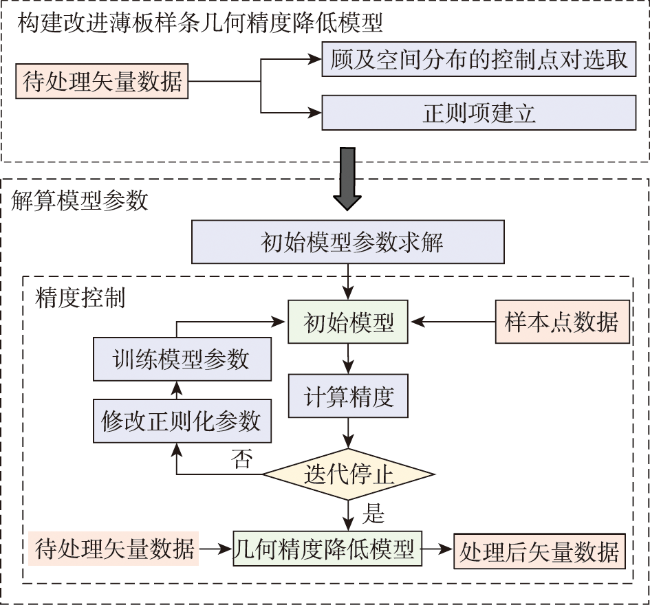
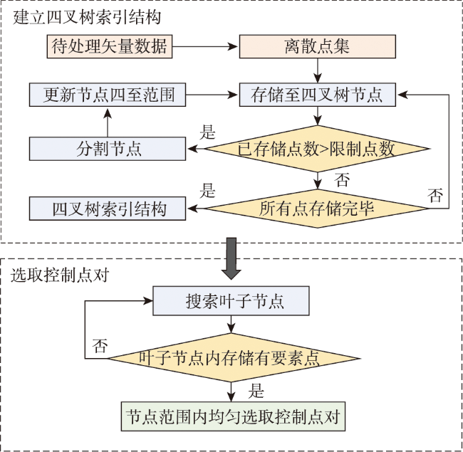
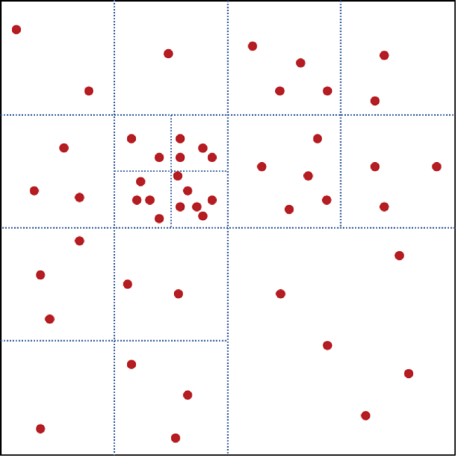
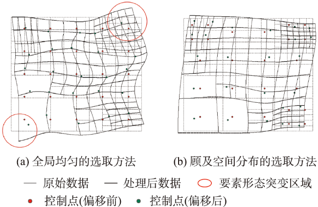
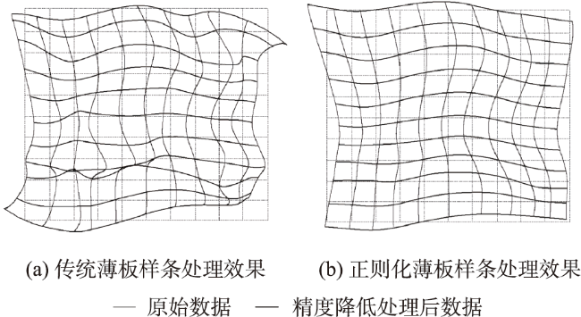
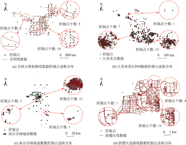
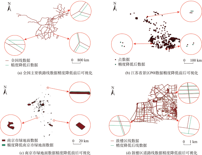
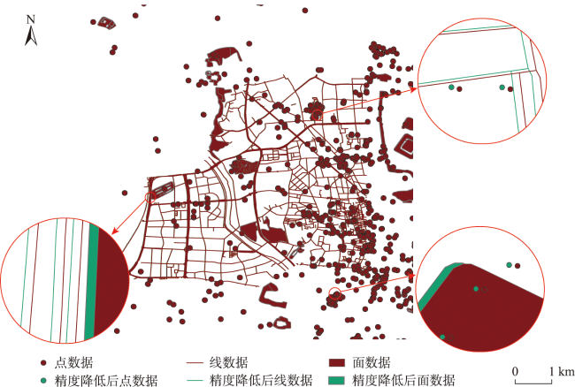
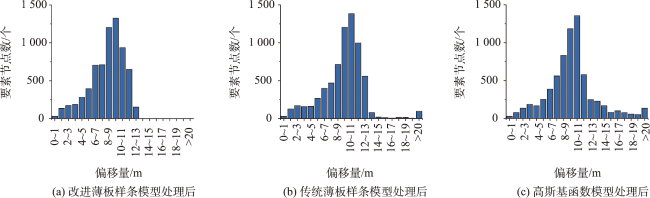
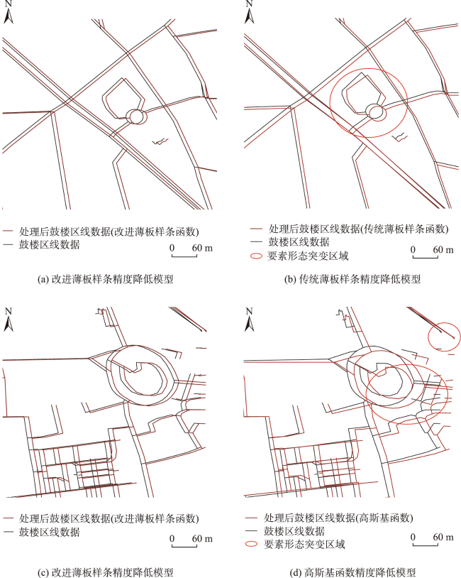
随着测绘地理信息数据的共享应用成为趋势,地理数据的精度降低处理成为数据公开前不可缺少的环节。基于传统薄板样条插值的坐标偏移模型利用本身优势可以实现坐标变换从而降低数据的几何精度,但是该模型受控制点精确程度影响大,抗噪声能力弱,若控制点选取不合理则易产生要素形态畸变的问题,导致数据无法被使用。本文提出了一种顾及空间分布的改进薄板样条矢量数据精度降低方法,首先通过四叉树索引结构进行格网划分,分别在网格内选取控制点,使得选出的控制点对和原始矢量数据在空间分布特征和数量特征上一致。然后基于Tikhonov正则化思想在原始坐标偏移模型中添加正则化项,弱化控制点的约束作用,增强模型抗噪声能力。本文选取不同尺度、不同类型以及多图层数据进行精度降低测试,实验表明: ① 本文算法针对不同实验数据都可以满足自然资源部95号文公开地图精度不高于10 m的要求,模型普适性好且效率较高; ② 本文算法能有效提高模型的稳定性以及减少处理后坐标突变的问题。以南京市鼓楼区线数据为测试数据的计算结果表明,精度降低后数据空间方向一致性为99.62%,图形形态相似性为99.99%,均优于传统薄板样条模型与高斯基函数坐标偏移模型; ③ 本文算法使精度降低后数据的偏移效果实现局部一致性以及全局随机性,精度降低后数据在明攻击或盲攻击的情况下精度仍能保持在10 m左右,说明坐标偏移结果不易被恢复。本研究证明提出的顾及空间分布的改进薄板样条精度降低模型兼顾处理后数据的安全性以及可用性,促进了矢量地理数据的社会化应用。

王敏璇 , 阳璇 , 查启航 , 孙睿 , 任娜 . 顾及空间分布的改进薄板样条矢量数据几何精度降低方法[J]. 地球信息科学学报, 2023 , 25(11) : 2120 -2133 . DOI: 10.12082/dqxxkx.2023.230206
With the sharing and application of surveying and mapping geographic information data, the accuracy reduction of geographic data prior to data release has become an essential step to avoid leaks of classified high-precision data that could threaten national security. Geometric accuracy reduction is an important component of geographic data accuracy reduction, which refers to transforming the coordinates of element points and reducing the precision of the publicly available data. The traditional thin plate spline interpolation model can achieve coordinate transformation with its advantages. However, this model is easily influenced by the accuracy of control points and is not robust against noise. For example, if the control points are not selected reasonably, data morphological distortion easily occurs due to noisy control points, resulting in poor data quality. In this article, a vector data accuracy reduction method considering spatial distribution based on the improved thin plate spline model is proposed. Firstly, the grid is divided by quadtree index structure. The control points are selected in each grid, so that the selected control points are consistent with the original vector data in terms of spatial distribution and quantitative characteristics. Then, regularization terms are added to the traditional function based on Tikhonov regularization to weaken the constraint imposed by control points and enhance the anti-noise ability of the model. We choose vector geographic data with different scales and types and multi-layer vector geographic data for experiments. Results show that: (1) Based on different experimental data, our algorithm can meet the requirement that the procerssed data precision should not exceed 10 meters according to the No.95 official document from the Ministry of Natural Resources, which demonstrates the model adaptability and efficiency; (2) The algorithm can effectively improve model stability and reduce abrupt changes in coordinates. The experiment conducted on the line data of Gulou District in Nanjing shows that, the processed data exhibit a spatial directional consistency of 99.62% and a graphical morphological similarity of 99.99%, which outperforms the results based on traditional thin plate spline model and guassian radial basis function model; (3) The offset effect is locally consistent and globally random. The processed of the processed data after either direct attacking or blind attacking remains around 10 meters, indicating the difficulty of recovering processed data to original results. This research proves that the proposed model can balance data's security and availability, promoting social application of vector geographic data.
表1 待处理数据基本信息Tab. 1 Basic information of the data to be prcessed |
| 数据 | 类型 | 范围 | 要素节点数/个 | 坐标范围 |
|---|---|---|---|---|
| 1 | 线要素 | 全国 | 47 580 | 84°42′29″ E—131°12′45″ E, 21°10′26″ N—53°00′16″ N |
| 2 | 点要素 | 江苏省 | 8 222 | 116°34′42″ E—121°42′15″ E, 30°51′38″ N—34°54′52″N |
| 3 | 面要素 | 南京市 | 22 614 | 118°29′26″ E—119°06′53″ E, 31°16′58″ N—32°31′47″ N |
| 4 | 线要素 | 鼓楼区 | 6 874 | 118°42′56″ E—118°46′41″ E,32°02′22″ N—32°05′30″ N |
表2 处理后精度及最大最小偏移量统计Tab. 2 Statistics of RMSE and maximum/minimum offset value of the processed data |
| 数据 | 精度/m | 速度/(kb/s) | 最小偏移量/m | 最大偏移量/m |
|---|---|---|---|---|
| 1 | 10.246 1 | 363.342 0 | 0.09 | 13.32 |
| 2 | 10.517 3 | 644.348 0 | 0.19 | 17.71 |
| 3 | 10.756 7 | 756.551 6 | 0.54 | 16.33 |
| 4 | 10.467 6 | 526.079 4 | 0.28 | 12.59 |
表3 精度降低后要素节点偏移方向统计Tab. 3 Statistics of offset direction of the nodes after accuracy reduction |
| 数据 | 偏移方向 | |||||||
|---|---|---|---|---|---|---|---|---|
| 东北/个 | 占比/% | 东南/个 | 占比/% | 西北/个 | 占比/% | 西南/个 | 占比/% | |
| 1 | 9 766 | 20.53 | 13 009 | 27.34 | 14 468 | 30.41 | 10 337 | 21.73 |
| 2 | 2 221 | 27.01 | 1 804 | 21.94 | 2 028 | 24.67 | 2 169 | 26.38 |
| 3 | 5 502 | 24.33 | 5 550 | 24.54 | 5 662 | 25.04 | 5 900 | 26.09 |
| 4 | 1 982 | 28.83 | 1 453 | 21.14 | 1 929 | 28.06 | 1 510 | 21.97 |
图9 精度降低后要素节点偏移方向统计Fig. 9 Statistics of offset direction of the nodes after accuracy reduction |
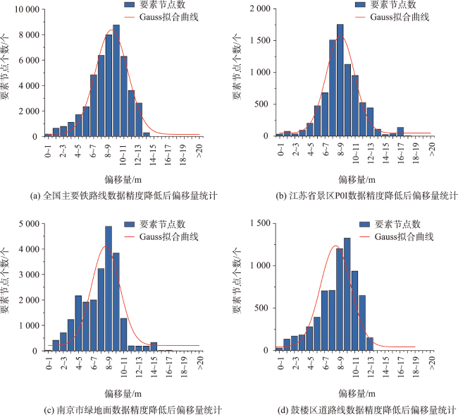
表4 精度降低后要素节点偏移量统计Tab. 4 Statistics of offset value of the nodes after accuracy reduction |
| 数据 | 偏移量/m | |||||||
|---|---|---|---|---|---|---|---|---|
| 0~2 | 2~5 | 5~8 | 8~11 | 11~14 | 14~17 | 17~20 | >20 | |
| 1 | 840 | 3 624 | 13 553 | 23 026 | 6 537 | 0 | 0 | 0 |
| 2 | 107 | 334 | 2 669 | 3 835 | 1 076 | 197 | 4 | 0 |
| 3 | 438 | 4 103 | 7 140 | 10 001 | 568 | 364 | 0 | 0 |
| 4 | 165 | 637 | 1 808 | 3 463 | 801 | 0 | 0 | 0 |
表5 明攻击/盲攻击后数据精度统计Tab. 5 Statistics of RMSE after clear attacking and blind attacking |
| 攻击方式 | 数据 | 同名点/对 | 精度/m |
|---|---|---|---|
| 盲攻击 | 校正数据1 | 50 | 10.222 3 |
| 校正数据2 | 150 | 10.133 5 | |
| 校正数据3 | 300 | 10.225 6 | |
| 校正数据4 | 500 | 9.955 6 | |
| 明攻击 | 校正数据5 | 33 | 11.236 4 |
表6 3种算法降低精度与数据可用性对比Tab. 6 Comparison of RMSE and data availability after accuracy reduction based on three models |
| 处理模型 | 处理后 精度/m | 空间方向一致性/% | 图形形态相似性/% |
|---|---|---|---|
| 改进薄板样条模型 | 10.467 6 | 99.62 | 99.99 |
| 传统薄板样条模型 | 10.552 2 | 94.10 | 99.97 |
| 高斯函数模型 | 12.389 0 | 93.76 | 99.98 |
| [1] |
自然资源部,国家保密局. 测绘地理信息管理工作国家秘密范围的规定[EB/OL].(2020). https://www.gov.cn/zhengce/zhengceku/2020-07/08/content_5525075.htm.
[ Ministry of Natural Resources of the People's Republic of China, National Administration of State Secrets Protection. Regulations on the scope of state secrets in the management of geographic information in surveying and mapping[EB/OL].(2020). https://www.gov.cn/zhengce/zhengceku/2020-07/08/content_5525075.htm. ]
|
| [2] |
聂时贵, 刘玫, 王会娜. 基于ArcGIS的江苏省地理信息公共服务平台数据脱密方法[J]. 现代测绘, 2012, 35(6):42-44.
|
| [3] |
朱长青, 任娜, 徐鼎捷. 地理信息安全技术研究进展与展望[J]. 测绘学报, 2022, 51(6):1017-1028.
|
| [4] |
王忠美, 杨晓梅, 顾行发, 等. 投影相似变换的无人机影像拼接[J]. 测绘科学, 2016, 41(9):112-117.
|
| [5] |
赖明珠, 段志鸣. 基于局部特征射影变换的组织切片图像非刚性配准[J]. 科学技术与工程, 2022, 22(29):12954-12962.
|
| [6] |
胡安文, 张祖勋. 对高分辨率遥感影像基于仿射变换的严格几何模型的讨论[J]. 武汉大学学报·信息科学版, 2006, 31(2):104-107.
|
| [7] |
白晓春, 戚国辉, 郑树海, 等. 输变电工程地理信息数据脱密处理研究[J]. 矿产勘查, 2019, 10(9):2446-2460.
|
| [8] |
江栋华, 周卫. 一种基于Chebyshev多项式的矢量数据几何精度脱密模型[J]. 测绘科学技术学报, 2018, 35(3):321-325.
|
| [9] |
刘宏林, 吕晓华, 江南, 等. 影响地图投影多项式变换精度的若干因素分析[J]. 测绘科学技术学报, 2011, 28(2):108-112.
|
| [10] |
于辉, 周卫, 马心念. 一种基于三角函数的矢栅地理数据可逆几何脱密模型[J]. 测绘通报, 2017(10):89-94.
|
| [11] |
|
| [12] |
于辉. 基于径向基和三角函数的矢栅一体化脱密模型研究[D]. 南京: 南京师范大学, 2016.
|
| [13] |
高隆杰. 基于径向基函数的DLG几何精度脱密模型研究[D]. 南京: 南京师范大学, 2014.
[
|
| [14] |
|
| [15] |
黄华峰, 陈飞, 曾勋勋. 基于薄板样条配准和全局相似的图像交互拼接[J]. 南京大学学报(自然科学), 2021, 57(5):828-837.
|
| [16] |
|
| [17] |
徐旺, 官云兰, 张钊, 等. 结合薄板样条插值的机载LiDAR渐进形态学滤波算法[J]. 激光与光电子学进展, 2022, 59(10):412-421.
|
| [18] |
张煜, 李树祥, 陈武凡, 等. 薄板样条插值函数的改进与应用[J]. 中国图象图形学报(A辑), 2003, 8(z1):46-49.
|
| [19] |
张永军, 黄星北, 刘欣怡. 一种地形自适应的机载LiDAR点云正则化TPS滤波方法[J]. 地球信息科学学报, 2020, 22(4):898-908.
|
| [20] |
|
| [21] |
姚晓闯. 矢量大数据管理关键技术研究[J]. 测绘学报, 2018, 47(3):423.
|
| [22] |
林东方, 朱建军, 宋迎春, 等. 正则化的奇异值分解参数构造法[J]. 测绘学报, 2016, 45(8):883-889.
|
| [23] |
林东方, 朱建军, 付海强, 等. 均方误差意义下的正则化参数二次优化方法[J]. 测绘学报, 2020, 49(4):443-451.
|
| [24] |
段先云, 邓学雄, 左启阳. 级进模刃孔图形复杂度的研究[J]. 工程图学学报, 2006, 27(5):94-97.
|
| [25] |
李安波, 吴雪荣, 解宪丽, 等. 精度可控的矢量地理数据脱密方法[J]. 中国矿业大学学报, 2016, 45(5):1050-1057.
|
/
| 〈 |
|
〉 |
