
基于路径模拟和空间句法的封闭式非门禁居住小区犯罪人逃逸行为研究
|
朱佳波(1998— ),男,浙江绍兴人,硕士生,主要研究方向为城市安全与疏散管理。E-mail: 545507705@qq.com。 |
收稿日期: 2023-05-13
修回日期: 2023-06-20
网络出版日期: 2023-11-02
基金资助
国家重点研发计划项目(2021YFE0200100)
2021年度江苏省政策引导类计划(BZ2021015)
中国犯罪学学会2022年度研究重点课题(FZXXH2022B03)
安徽省社会科学创新发展研究课题(2020CX033)
Research on the Escape Behavior of Criminals in Closed Non-gated Communities Based on Path Simulation and Space Syntax
Received date: 2023-05-13
Revised date: 2023-06-20
Online published: 2023-11-02
Supported by
National Key Research and Development Program of China(2021YFE0200100)
2021 Policy Directed Programs of Jiangsu Province(BZ2021015)
Research Priorities for the Chinese Society of Criminology in 2022(FZXXH2022B03)
Research Topics for the Innovative Development of Social Sciences in Anhui Province(2020CX033)
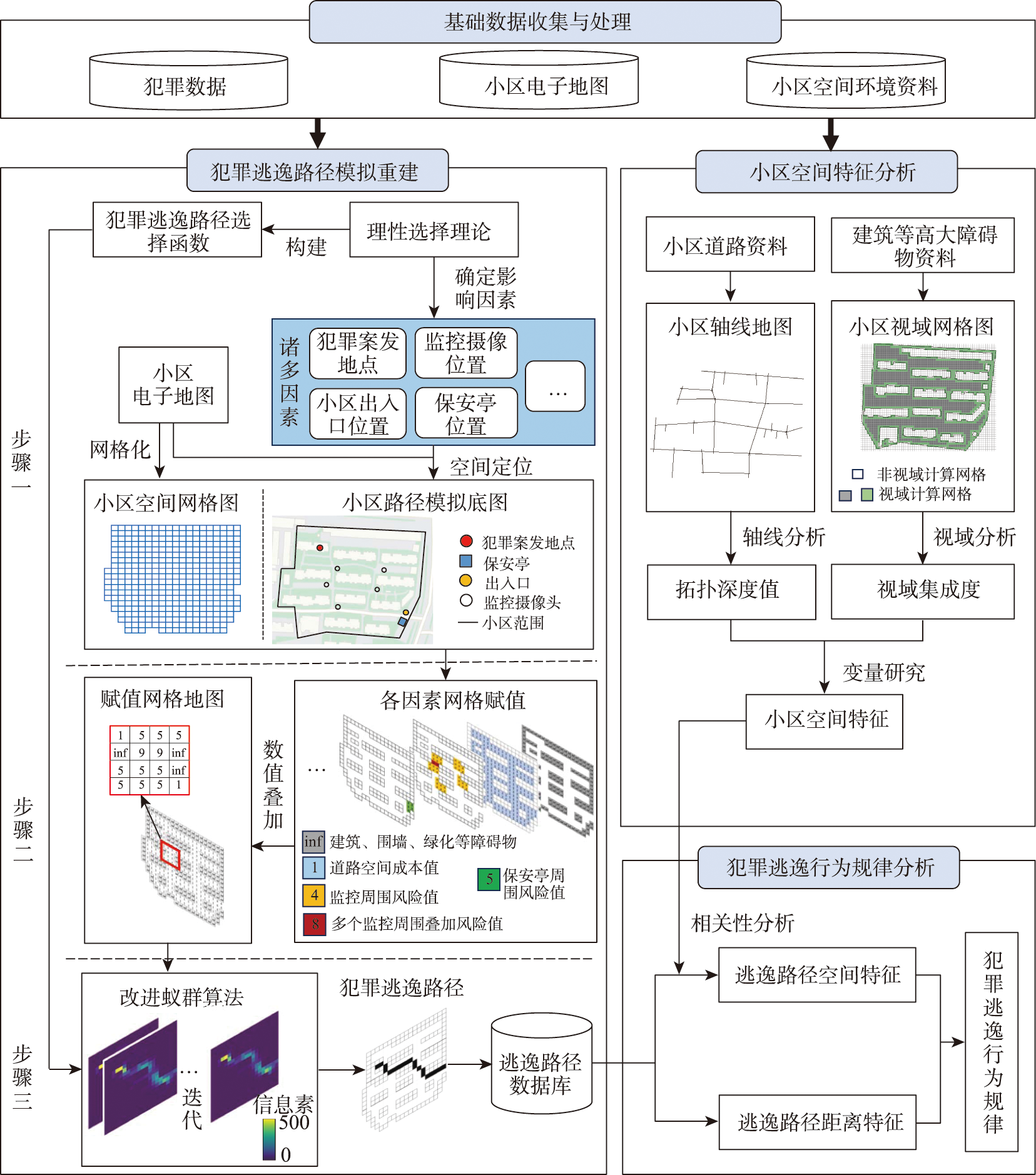
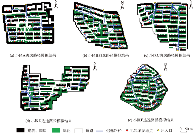
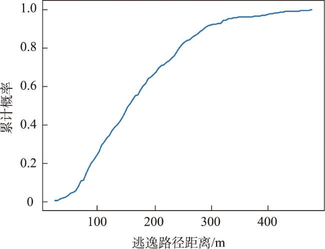
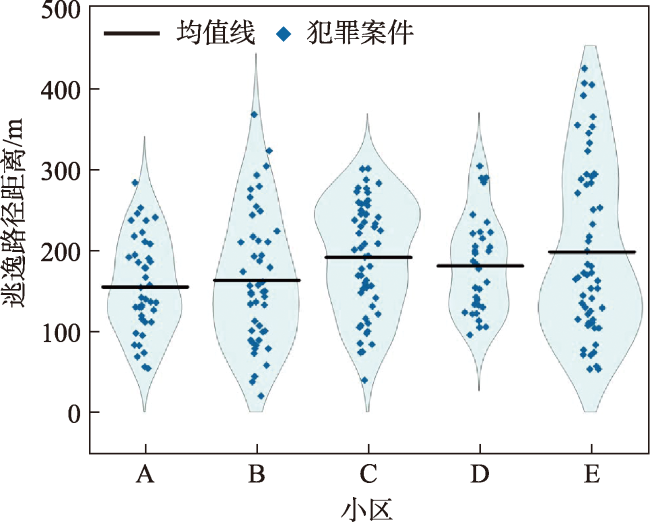
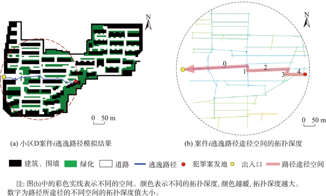
犯罪人的犯罪出行行为研究有助于更好地理解犯罪发生的机理。目前已有的研究大多集中于犯罪前出行行为,缺少有关犯罪后出行,即犯罪逃逸行为的研究。本文聚焦于封闭式非门禁居住小区的犯罪人逃逸行为,提出一种通过微观路径模拟结合宏观空间分析的犯罪逃逸行为研究方法。方法首先通过模拟重建犯罪逃逸路径解决研究数据匮乏的问题,具体为基于理性选择理论构建逃逸路径选择函数,采用赋值网格地图量化小区空间环境,使用改进蚁群算法在赋值网格地图上迭代模拟得到路径数据;然后通过空间句法理论解构小区空间在拓扑深度和视域集成度上的空间特征;最后综合犯罪逃逸路径数据和小区空间特征探究犯罪人逃逸行为规律。研究针以Z市5个典型居住小区的外来人员夜间单次盗窃案件为研究对象进行了实证研究,结果表明:犯罪人的逃逸距离有明显的距离衰减特性,并呈现两端衰减;逃逸距离与出入口数量负关联;犯罪人逃逸时会规避视域集成度高的区域且路径轨迹符合空间拓扑规则。研究结论为居住小区的规划布局或建设改造提供了一定的参考,居住小区需重视出入口的规划布局,根据空间位置合理分配犯罪防控资源以及将景观环境设计与小区安全相结合。
朱佳波 , 王益 , 张拾斤 , 陈家亮 , 杨璐 . 基于路径模拟和空间句法的封闭式非门禁居住小区犯罪人逃逸行为研究[J]. 地球信息科学学报, 2023 , 25(11) : 2178 -2190 . DOI: 10.12082/dqxxkx.2023.230264
Studying the journey-to-crime contributes to a better understanding of the mechanisms behind crime occurrence. However, existing research has primarily focused on pre-crime travel behavior, lacking sufficient investigation into post-crime travel, specifically criminal escape behavior. This paper focuses on the escape behavior of criminals in closed non-gated communities and proposes a research methodology that combines micro-level path simulation with macro-level spatial analysis to study criminal escape behavior. The method begins by addressing the problem of limited research data through the simulation-based reconstruction of criminal escape paths. Specifically, it involves constructing an escape path selection function based on rational choice theory, quantifying the spatial environment of the community using an assignment grid map, and iteratively simulating path data using an improved ant colony algorithm on the assignment grid map. Next, the method employs spatial syntax theory to deconstruct the spatial characteristics of the community in terms of topological depth and visual integration. Finally, by integrating the criminal escape path data with the spatial characteristics of the community, the spatial logic of criminal escape behavior is explored. The study conducted an empirical research focusing on night theft cases committed by outsiders in five typical communities in Z city, and the results show that: (1) Criminals' escape distances displayed a clear distance decay characteristic, and it also shows the decay effect at both ends; (2) The unique built environment and spatial structure of the community significantly affect the criminal behavior. Communities with too many entrances and exits tend to have shorter escape distances for criminals; (3)Criminals will avoid places with high visual integration and look for more concealed spaces to escape; (4) Criminal escape behaviors conform to the rules of space topology, that is, they will choose spaces with small topological depths to escape and follow the descending path of topological depths escape. The research findings provide a reference for the planning and construction transformation of communities. For example, communities should: emphasize the layout of entrances and exits, providing convenience for residents while minimizing the number of entry and exit points; strengthen the management of areas with a moderate distance from entrances and exits, and allocate more crime prevention and control resources in this area, such as increasing security patrols; integrate landscape design with community safety considerations, such as limiting the planting of shrubs that may obstruct pedestrians' sightlines, thus increasing the visual integration of community space.
表1 封闭式非门禁居住小区犯罪逃逸行为成本和风险的影响因素Tab. 1 Influencing factors of cost and risk of criminal escape behavior in closed non-gated community |
| 空间环境 | 理论和实证依据 | 影响成本 | 影响风险 | |
|---|---|---|---|---|
| 自然监视(人) | 摄像头监视 | |||
| 障碍物(围栏、墙) | 围栏、墙之类的障碍物干预陌生人进入空间的可能性,减少犯罪机会[31],因此也限制了犯罪人的逃逸路线 | √ | ||
| 出入口(位置) | 出入口通常是犯罪人的逃逸通道 | √ | ||
| 监控摄像头 | 监控可增加犯罪行为被观察到的概率,增加犯罪防御能力,从而降低犯罪率[32] | √ | ||
| 路灯 | 路灯可增强自然监视,增加犯罪行为被观察的概率,有研究显示强化英国道路照明可降低20%的犯罪[33] | √ | ||
| 底矮且坚实的灌木 | 低矮的树木可为犯罪行为提供遮蔽,降低犯罪行为被发现的可能[34] | √ | ||
| 高大的树木 | 高大的树木形成的林荫道促进居民活动,增加自然监视,提高犯罪人被发现的可能[25] | √ | ||
| 安保力量(保安亭,保安巡逻) | 小区的安保力量与盗窃被抓的风险成正比[4] | √ | ||
| 户外活动场所,公共座椅等设置 | 公共座椅、户外活动场所等可提升居民的活动支持,增加自然监视,提高了犯罪人被发现的可能性[35] | √ | ||
表2 空间句法变量的定义和计算方法Tab. 2 Definition and calculation formula of space syntax variables |
| 变量名称 | 变量意义 | 计算公式 | 变量说明 | 公式编号 |
|---|---|---|---|---|
| 拓扑深度值(Dij) | 反映单元空间i到另一个单元空间j的最短里程(即最小步数),越小表示两者之间越便捷。 | Dn表示单元空间i到单元空间j第n种里程 | (8) | |
| 区域平均拓扑深度值(DiA) | 反映单元空间i到某一区域空间A的最短里程(即最小步数),越小表示两者之间越便捷,区域是多个空间的集合。 | Dij表示单元空间i到区域A中的第j个单元空间的拓扑深度值,n为区域A中的单元空间数量 | (9) | |
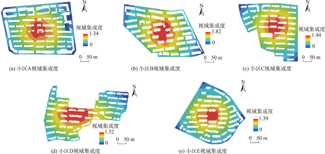
| 视域集成度(Vli) | 视域集成度表示单元空间能否被其他空间看到的程度,集成度越高,空间可视性越好。 | 为平均视域深度; m为视域网格地图中排除障碍物的网格数 | (10) |
表3 小区基本信息Tab. 3 Basic information of the communities |
| 住区 | A | B | C | D | E |
|---|---|---|---|---|---|
| 占地面积/m2 | 152 997 | 166 522 | 152 868 | 148 866 | 165 159 |
| 横向边界间距/m | 502 | 560 | 545 | 500 | 520 |
| 纵向边界间距/m | 426 | 485 | 430 | 430 | 510 |
| 人口数量/人 | 4 628 | 4 919 | 4 610 | 4 353 | 4 891 |
| 出入口数量/个 | 6 | 10 | 3 | 2 | 4 |
| 保安亭数量/个 | 6 | 0 | 3 | 2 | 4 |
| 保安巡逻情况 | 无 | 无 | 无 | 无 | 无 |
| 监控摄像头数量/个 | 51 | 35 | 15 | 50 | 10 |
| 犯罪案件数/件 | 41 | 47 | 58 | 33 | 57 |
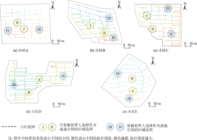
表4 不易被选择区域和易被选择区域的区域平均拓扑深度值Tab. 4 Average topological depth values of non- selected areas and easily selected areas |
| 居住小区 | A | B | C | D | E | |||||
|---|---|---|---|---|---|---|---|---|---|---|
| 不易被选择区域 | I | Ⅱ | Ⅰ | Ⅱ | Ⅰ | Ⅱ | Ⅰ | Ⅱ | I | Ⅱ |
| 区域平均拓扑深度值 | 2.75 | 2.67 | 3.17 | 2.75 | 2.0 | 2.67 | 3.00 | 3.20 | 3.60 | 3.33 |
| 易被选择区域 | Ⅲ | Ⅳ | Ⅲ | Ⅳ | Ⅲ | Ⅳ | Ⅲ | Ⅳ | Ⅲ | Ⅳ |
| 区域平均拓扑深度值 | 0.33 | 0.50 | 1.16 | 1.42 | 0.75 | 0.00 | 1.20 | 0.67 | 0.75 | 0.83 |
| [1] |
赵梓渝, 刘大千, 高雪, 等. 基于人口学特征的犯罪者行为时空倾向——以长春市南关区为例[J]. 地理科学, 2021, 41(8):1409-1418.
|
| [2] |
刘大千, 宋伟, 修春亮. 贝叶斯方法在犯罪时空格局研究上的应用——以长春市为例[J]. 地理科学, 2022, 42(5):820-830.
|
| [3] |
宋广文, 肖露子, 周素红, 等. 居民日常活动对扒窃警情时空格局的影响[J]. 地理学报, 2017, 72(2):356-367.
|
| [4] |
肖露子, 柳林, 宋广文, 等. 基于理性选择理论的社区环境对入室盗窃的影响研究[J]. 地理研究, 2017, 36(12):2479-2491.
|
| [5] |
张超鹏, 陈鹏, 江欢, 等. X市入室盗窃犯罪人空间出行距离及其影响因素分析[J]. 地球信息科学学报, 2022, 24(10):1957-1967.
|
| [6] |
赵梓渝, 刘大千, 肖建红, 等. 基于犯罪模式理论的犯罪出行空间特征与影响因素——以长春市南关区扒窃为例[J]. 地理研究, 2021, 40(3):885-899.
|
| [7] |
柳林, 刘文娟, 廖薇薇, 等. 基于随机森林和时空核密度方法的不同周期犯罪热点预测对比[J]. 地理科学进展, 2018, 37(6):761-771.
[
|
| [8] |
柳林, 纪佳楷, 宋广文, 等. 基于犯罪空间分异和建成环境的公共场所侵财犯罪热点预测[J]. 地球信息科学学报, 2019, 21(11):1655-1668.
|
| [9] |
|
| [10] |
|
| [11] |
|
| [12] |
侯超, 陈鹏, 曾昭龙, 等. 不同主体特征的犯罪人空间出行行为分析[J]. 地理科学进展, 2020, 39(4):602-613.
|
| [13] |
龙冬平, 柳林, 陈建国, 等. 街头抢劫者前犯罪经历对其后作案地选择的影响[J]. 地理科学进展, 2020, 39(5):815-828.
|
| [14] |
王增利, 刘学军, 陆娟. 入室盗窃多尺度地理因子分析[J]. 地理学报, 2017, 72(2):329-340.
|
| [15] |
|
| [16] |
|
| [17] |
|
| [18] |
黎家琪, 宋广文, 肖露子, 等. 盗窃者犯罪出行距离的特征及其影响因素——基于居住社区、作案社区及出行物理障碍的综合考虑[J]. 地理科学进展, 2022, 41(11):2123-2134.
|
| [19] |
|
| [20] |
|
| [21] |
|
| [22] |
|
| [23] |
|
| [24] |
|
| [25] |
龙冬平, 柳林, 冯嘉欣, 等. 社区环境对入室盗窃和室外盗窃影响的对比分析——以ZG市ZH半岛为例[J]. 地理学报, 2017, 72(2):341-355.
|
| [26] |
李春雷, 姚巍. 城市化进程中我国城市住区犯罪空间防控探索——基于CPTED理论视角下对我国城市住区的个案考察[J]. 中国人民公安大学学报(社会科学版), 2011, 27(4):93-105.
[
|
| [27] |
杨刚斌, 柳林, 何深静, 等. 基于多层次模型的广州门禁小区家庭入室盗窃环境影响分析[J]. 热带地理, 2016, 36(4):610-618.
|
| [28] |
|
| [29] |
|
| [30] |
|
| [31] |
|
| [32] |
|
| [33] |
|
| [34] |
|
| [35] |
|
| [36] |
王益, 吴永发. 基于句法变量分析的徽州古村落空间安全机制研究[J]. 规划师, 2016, 32(3):101-107.
[
|
| [37] |
郑文升, 卓蓉蓉, 罗静, 等. 基于空间句法的武汉城区“两抢一盗”犯罪分布环境[J]. 地理学报, 2016, 71(10):1710-1720.
|
| [38] |
|
| [39] |
王益. 从犯罪预防看徽州古村落的空间结构特征[J]. 城市规划, 2020, 44(12):87-94.
|
| [40] |
|
/
| 〈 |
|
〉 |
