
气候变化背景下沿海特大城市复合洪水灾害空间模拟
|
孙钦珂(1995— ),男,山东济宁人,博士生,研究方向为城市灾害与风险分析。E-mail: qksun2020@gmail.com |
收稿日期: 2023-06-12
修回日期: 2023-09-25
网络出版日期: 2023-12-05
基金资助
国家重点研发计划项目(2022YFC3800705)
甘肃省自然科学基金重点项目(21JR7RA278)
甘肃省自然科学基金重点项目(21JR7RA281)
Spatial Simulation of Compound Flood Hazard Risk in Coastal Megacities under Climate Change
Received date: 2023-06-12
Revised date: 2023-09-25
Online published: 2023-12-05
Supported by
National Key Research and Development Program of China(2022YFC3800705)
Natural Science Foundation of Gansu Province(21JR7RA278)
Natural Science Foundation of Gansu Province(21JR7RA281)
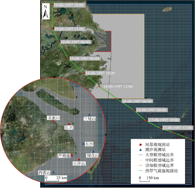
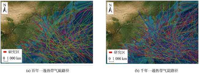
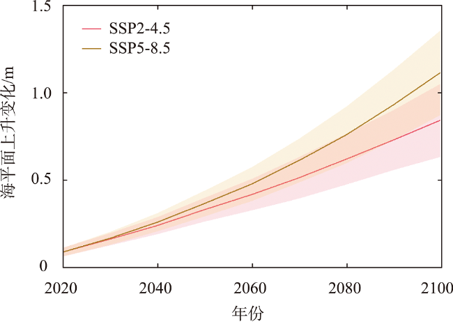
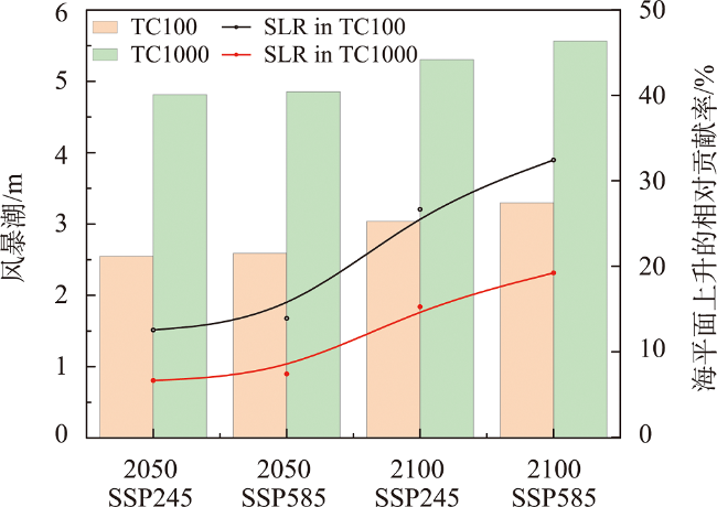
地势低洼、人口稠密的沿海地区发生的风暴潮复合洪水灾害可能会造成毁灭性的社会、经济和生态影响。全球气候变化导致的海平面上升以及热带气旋强度和频率的增加将加剧这种影响。为了保护沿海地区免受洪水的侵袭,必须准确评估热带气旋造成的复合洪水灾害。然而,关于气候变化对沿海地区热带气旋复合洪水风险的研究还很有限。本文基于EC-EARTH3P气候模式,选取STORM模型合成的气候变化热带气旋轨迹数据集,通过耦合Delft3D FLOW & WAVE流体动力学模型来模拟风场和波浪非线性作用导致的复合水位对沿海地区的影响,并研究了不同SSPs(Shared Socioeconomic Pathways)情景下热带气旋和海平面上升对沿海风暴潮复合洪水的贡献,研究以沿海特大城市上海市为例。结果表明,气候变化对风暴潮复合洪水产生重要影响,且受未来气旋路径及强度的影响,复合洪水表现出较大的空间差异和水位差异。此外,未来海平面上升将使上海地区面临更严重的洪水灾害。研究发现,虽然海平面上升会进一步加剧沿海风暴潮复合洪水灾害的影响,但热带气旋对未来沿海复合洪水的影响更大。本文设计的复合洪水分析框架可用于研究其他低洼沿海地区未来的风暴潮复合洪水灾害,研究结果不仅可以为洪水风险管理人员识别风险区域提供相关研究基础,而且对沿海适应性措施和城市应急响应规划具有重要意义。

孙钦珂 , 周亮 , 王宝 . 气候变化背景下沿海特大城市复合洪水灾害空间模拟[J]. 地球信息科学学报, 2023 , 25(12) : 2427 -2438 . DOI: 10.12082/230326.2023.230326
Coastal megacities are typically situated in low-lying and densely populated areas. The occurrence of storm surge compound flooding has the potential to result in catastrophic social, economic, and ecological impacts for these coastal cities. The rising sea levels and the increased intensity and frequency of tropical cyclones caused by global warming will exacerbate the challenges faced by coastal cities. Therefore, accurately assessing compound flooding events caused by tropical cyclones is critical to protecting coastal areas from inundation. However, research on the impact of climate change on the risk of tropical cyclone induced compound flooding in coastal areas is still limited. In this study, we used the EC-EARTH3P climate model and selected a dataset of climate change tropical cyclone trajectories synthesized by the STORM model. This dataset is generated using historical data from the International Best Track Archive for Climate Stewardship (IBTrACS) to simulate synthetic tropical cyclones under future climate conditions. Subsequently, we used the coupled Delft3D FLOW & WAVE hydrodynamic model to simulate the impact of storm surge compound water levels on coastal areas due to the nonlinear effects of tropical cyclones wind fields and waves. Furthermore, we investigated the contributions of tropical cyclones and sea level rise to coastal storm surge compound flooding under different Shared Socioeconomic Pathways (SSPs) scenarios, taking the Shanghai city, located within an estuary and along the coastline of China, as our case study. The results showed that climate change had a significant impact on storm surge compound flooding. The future compound flooding disasters exhibited spatial variations in shanghai and differences in water level heights, influenced by future cyclone paths and intensities. Among these areas, Chongming district was the most seriously affected area by storm surge compound flooding. In addition, sea level rise under different climate scenarios will lead to more severe flood hazards in the Shanghai area. We found that although sea level rise will further intensify the impact of storm surge compound flooding in Shanghai, tropical cyclones will have a greater influence on future compound flooding in the city. The spatial risk analysis framework for compound flooding hazards under climate change designed in this study can also be applied to research future storm surge compound flooding hazards in other coastal megacities. Our research findings not only provide a foundational basis for policymakers and flood risk managers to identify risk vulnerable areas, but also provide significant implications for coastal adaptation measures and urban emergency response planning.
表1 数据来源及简介Tab. 1 Data source and introduction |
| 数据类型 | 数据详情 | 年份 | 数据来源 |
|---|---|---|---|
| 高程数据 | SRTM 高程数据 | 2022 | https://search.earthdata.nasa.gov/search?q=SRTM |
| 测深数据 | GEBCO_2022数据 | 2022 | https://www.gebco.net/data_and_products/gridded_bathymetry_data/gebco_2022 |
| 温妮路径 | 中国气象局热带气旋温妮的最佳路径 参数数据 | 1997 | https://tcdata.typhoon.org.cn/dlrdqx_zl.html |
| 温妮观测站点 | 上海气候中心温妮风暴潮观测站点数据 | 1997 | http://sh.cma.gov.cn/ |
| 潮汐信息 | OTIS潮汐振幅和相位 | 2020 | https://www.tpxo.net/otis |
| 潮汐观测站点 | IHO国际水文观测组织潮汐观测站点数据 | 2020 | https://iho.int/en/twcwg-tidal-data-sets-analysis |
| 海平面上升 | IPCC AR6不同气候情景最新海平面上升预测数据 | 2022 | https://sealevel.nasa.gov/ipcc-ar6-sea-level-projection-tool |
| [1] |
|
| [2] |
方佳毅, 殷杰, 石先武, 等. 沿海地区复合洪水危险性研究进展[J]. 气候变化研究进展, 2021, 17(3):317-328.
[
|
| [3] |
|
| [4] |
徐新良, 申志成, 李嘉豪, 等. “海上丝绸之路”主要海域热带气旋时空分布特征及其危险性[J]. 地球信息科学学报, 2020, 22(12):2383-2392.
[
|
| [5] |
|
| [6] |
|
| [7] |
石先武, 谭骏, 国志兴, 等. 风暴潮灾害风险评估研究综述[J]. 地球科学进展, 2013, 28(8):866-874.
[
|
| [8] |
|
| [9] |
许炜宏, 蔡榕硕. 海平面上升、强台风和风暴潮对厦门海域极值水位的影响及危险性预估[J]. 海洋学报, 2021, 43(5):14-26.
[
|
| [10] |
|
| [11] |
|
| [12] |
杨彩虹, 薛存金, 季民. 近30年西北太平洋热带气旋时空特征分析[J]. 地球信息科学学报, 2012, 14(5):611-617.
[
|
| [13] |
杨腾飞, 解吉波, 李振宇, 等. 微博中蕴含台风灾害损失信息识别和分类方法[J]. 地球信息科学学报, 2018, 20(7):906-917.
[
|
| [14] |
聂心宇, 谭红建, 蔡榕硕, 等. 利用区域气候模式预估未来登陆中国热带气旋活动[J]. 气候变化研究进展, 2023, 19(1):23-37.
[
|
| [15] |
|
| [16] |
武传号, 黄国如, 吴思远. 基于Copula函数的广州市短历时暴雨与潮位组合风险分析[J]. 水力发电学报, 2014, 33(2):33-40.
[
|
| [17] |
|
| [18] |
李倩, 俞海洋, 李婷, 等. 京津冀地区台风危险性评估——基于Gumbel分布的分析[J]. 地理科学进展, 2018, 37(7):933-945.
[
|
| [19] |
|
| [20] |
孙钦珂, 周亮, 唐相龙, 等. 干旱区绿洲城镇扩张对耕地空间影响及预测——以河西走廊区域为例[J]. 自然资源学报, 2021, 36(4):1008-1020.
[
|
| [21] |
王尔琪, 王少华. 未来GIS发展的技术趋势展望[J]. 测绘通报, 2015(S2):66-69.
[
|
| [22] |
|
| [23] |
|
| [24] |
|
| [25] |
方建, 杜鹃, 徐伟, 等. 气候变化对洪水灾害影响研究进展[J]. 地球科学进展, 2014, 29(9):1085-1093.
[
|
| [26] |
|
| [27] |
|
| [28] |
|
| [29] |
|
| [30] |
|
| [31] |
|
| [32] |
|
| [33] |
IPCC. IPCC Climate Change 2021: The Physical Science Basis, Contribution of Working Group I to the Third Assessment Report of the Intergovernmental Panel on Climate Change[R], Cambridge University Press, 2021.
|
| [34] |
|
| [35] |
|
| [36] |
|
| [37] |
|
| [38] |
|
| [39] |
|
/
| 〈 |
|
〉 |


