
基于可视化维度理论的泛地图知识推荐方法
|
韩德志(1999— ),男,山东临沂人,硕士生,主要从事地图学研究。E-mail: dezhihan@163.com |
Copy editor: 蒋树芳
收稿日期: 2023-04-10
修回日期: 2023-10-04
网络出版日期: 2024-03-26
基金资助
中国博士后科学基金面上项目(2023M732345)
国家自然科学基金面上项目(42171265)
广东省自然科学基金面上项目(2022A1515012120)
国家自然科学基金重点项目(41930104)
深圳市城市数字孪生技术重点实验室(筹建启动)项目(ZDSYS20210623101800001)
Knowledge Recommendation Method of Pan-Map Based on Visualization Dimension System
Received date: 2023-04-10
Revised date: 2023-10-04
Online published: 2024-03-26
Supported by
China Postdoctoral Science Foundation(2023M732345)
National Natural Science Foundation of China(42171265)
Natural Science Foundation of Guangdong Province(2022A1515012120)
Key Program of Natural Science Foundation of China(41930104)
Shenzhen Key Laboratory of Digital Twin Technologies for Cities(ZDSYS20210623101800001)
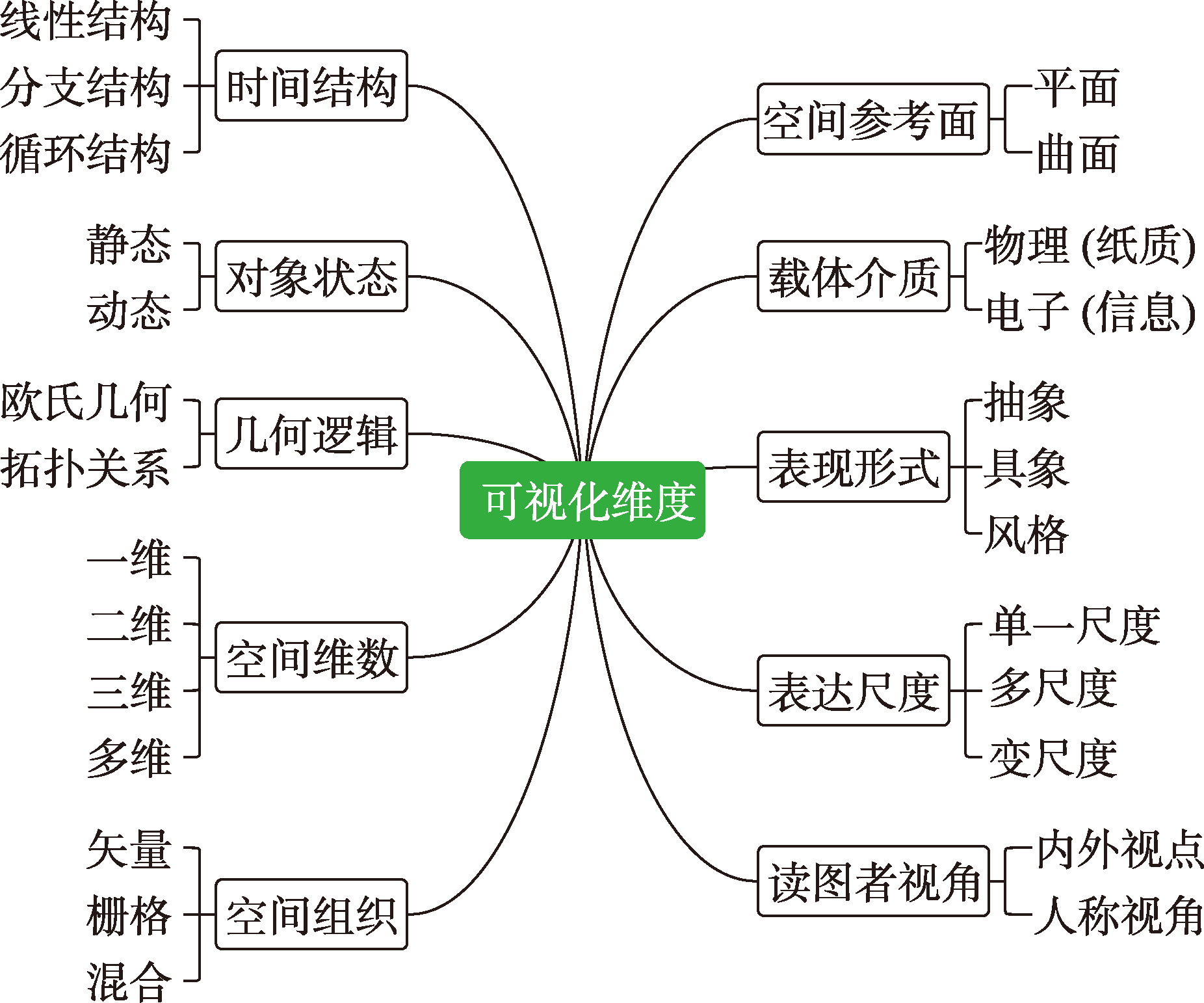
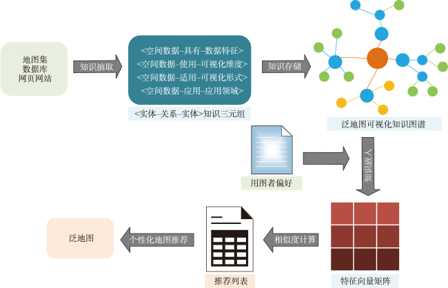
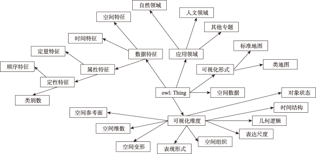
信息通讯时代,科学技术的进步极大地降低了地图制图的门槛,大量非专业制图人员涌现到地图制图领域,地图的表现形式呈现出显著的泛化趋势。然而,由于专业知识的缺失,普通大众在专题地图选择时容易产生“制图困惑”,难以确定恰当的专题地图类型。针对上述问题,本文尝试提出一种基于可视化维度理论的泛地图知识推荐方法。首先,面向专题制图需求,建立以空间数据、数据特征、泛地图可视化维度、泛地图可视化形式、应用领域为核心要素的泛地图可视化知识本体,通过知识抽取、知识存储操作,构建泛地图可视化知识图谱。其次,对知识图谱进行知识嵌入,实现地图可视化要素的知识化表达。最后,基于泛地图知识要素建立相似度计算模型,计算用户输入数据与知识图谱内空间数据特征、可视化维度、应用领域等的相似度,得出综合相似度结果,实现泛地图可视化形式的精准推荐。结果表明:面对泛化的专题信息表达,本研究提出的泛地图知识推荐方法能够为用图者的制图选择提供较为准确可视化参考,一定程度上满足普通大众的寻图需求。
韩德志 , 郭仁忠 , 陈业滨 , 赵志刚 , 柯文清 . 基于可视化维度理论的泛地图知识推荐方法[J]. 地球信息科学学报, 2024 , 26(1) : 110 -120 . DOI: 10.12082/dqxxkx.2024.230188
In the era of information and communication, the advancement of science and technology has greatly lowered the threshold for map-making, which has resulted in a large number of non-professional map-makers entering the field. As a result, maps have shown a significant diversification trend. However, due to a lack of professional knowledge, the general public often experiences "cartographic confusion" when choosing thematic maps, making it difficult to determine the appropriate types of thematic maps. To address these issues, this paper aims to propose a knowledge recommendation method for pan-maps based on visual dimension theory. Firstly, targeting the demands of thematic map-making, a pan-map visualization knowledge graph ontology is established, encompassing spatial data, data features, pan-maps visualization dimensions, pan-map visualization forms, and application domains. Through knowledge extraction and storage operations, a pan-map visualization knowledge graph is constructed. Secondly, knowledge embedding is applied to the knowledge graph to represent map visualization elements. Finally, based on the elements of pan-map knowledge graph, a similarity calculation model is established to compute the similarity between user input data and spatial data within the knowledge graph in terms of data features, visual dimensions, and application domains. The comprehensive similarity result is obtained to achieve accurate recommendations for the visual form of pan-maps. The results show that, in response to thematic application preferences, the proposed knowledge recommendation method for pan-maps based on visual dimension theory can provide accurate visual references for map selection, thereby meeting the map-searching needs of the general public.
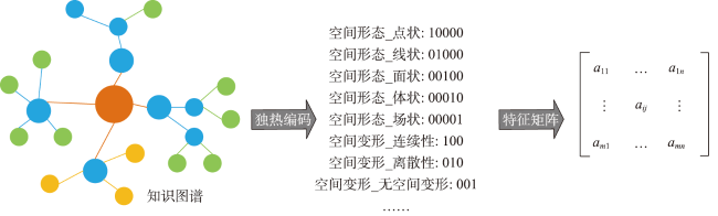
图4 独热编码知识嵌入示意图注: $\left.\left[\begin{array}{rrr}a_{_{11}}&\ldots&a_{_{1n}}\\\vdots&a_{_{ij}}&\vdots\\a_{_{m1}}&\cdots&a_{_{mn}}\end{array}\right.\right]$表示知识图谱独热编码后得到的特征向量矩阵; m表示空间数据条数; n 表示特征状态个数;aij表示第i个空间数据的第j个状态在特征向量矩阵中的编码;左图中不同颜色的节点表示知识图谱中不同类别实体,不同颜色的线表示不同实体关系。 Fig. 4 Diagram of knowledge embedding of one-hot encoding |
| [1] |
郭仁忠, 陈业滨, 应申, 等. 三元空间下的泛地图可视化维度[J]. 武汉大学学报·信息科学版, 2018, 43(11):1603-1610.
[
|
| [2] |
|
| [3] |
廖克. 中国地图学发展的回顾与展望[J]. 测绘学报, 2017, 46(10):1517-1525.
[
|
| [4] |
郭仁忠, 应申. 论ICT时代的地图学复兴[J]. 测绘学报, 2017, 46(10):1274-1283.
[
|
| [5] |
孟立秋. 地图学的恒常性和易变性[J]. 测绘学报, 2017, 46(10):1637-1644.
[
|
| [6] |
郭仁忠, 陈业滨, 赵志刚, 等. 泛地图学理论研究框架[J]. 测绘地理信息, 2021, 46(1):9-15.
[
|
| [7] |
郭仁忠, 陈业滨, 马丁, 等. 论ICT时代的泛地图表达[J]. 测绘学报, 2022, 51(7):1108-1113.
[
|
| [8] |
王家耀, 孙群, 王江霞. 地图学原理与方法[M]. 2版. 北京: 科学出版社, 2014.
[
|
| [9] |
应申, 窦小影, 徐雅洁, 等. 新型冠状病毒肺炎疫情可视化进展与分析[J]. 地球信息科学学报, 2021, 23(2):211-221.
[
|
| [10] |
王家耀. 地图科学技术:由数字化到智能化[J]. 武汉大学学报(信息科学版), 2022, 47(12):1963-1977.
[
|
| [11] |
任福, 翁杰, 王昭, 等. 关于智能地图制图的几点思考[J]. 武汉大学学报·信息科学版, 2022, 47(12):2064-2068.
[
|
| [12] |
田晶, 黄仁涛, 郭庆胜. 智能化专题地图表示方法选择的研究[J]. 测绘科学, 2007, 32(5):170-172,143,207.
[
|
| [13] |
江南, 马健, 武丽丽, 等. 面向自动推荐的表示方法规则的形式化表达研究[J]. 测绘通报, 2015(9):36-38,43.
[
|
| [14] |
王少华. 超图平台软件创新: SuperMap GIS地图慧简介[J]. 地球信息科学学报, 2016, 18(4):718.
[
|
| [15] |
吴明光, 孙彦杰, 闾国年. 地图风格迁移:概念、综述与展望[J]. 武汉大学学报·信息科学版, 2022, 47(12):2069-2084.
[
|
| [16] |
|
| [17] |
|
| [18] |
刘峤, 李杨, 段宏, 等. 知识图谱构建技术综述[J]. 计算机研究与发展, 2016, 53(3):582-600.
[
|
| [19] |
|
| [20] |
李连营, 彭楚骄, 郭邦祁, 等. 海洋地图可视化方法的知识图谱构建[J]. 测绘地理信息, 2022, 47(1):77-80.
[
|
| [21] |
彭楚骄, 李连营, 郭邦祁, 等. 使用知识图谱推荐专题地图可视化方法[J]. 测绘科学, 2022, 47(6):188-194.
[
|
| [22] |
|
| [23] |
|
| [24] |
|
| [25] |
遆鹏, 侯晓彤, 李志林, 等. 基于可视化维度的泛地图表达机制[J]. 武汉大学学报·信息科学版, 2022, 47(12):2015-2025.
[
|
| [26] |
郭仁忠, 陈业滨, 赵志刚, 等. ICT时代地图的科学概念及表达框架[J]. 武汉大学学报·信息科学版, 2022, 47(12):1978-1987.
[
|
| [27] |
陆锋, 余丽, 仇培元. 论地理知识图谱[J]. 地球信息科学学报, 2017, 19(6):723-734.
[
|
| [28] |
张明星, 张骁雄, 刘姗姗, 等. 利用知识图谱的推荐系统研究综述[J]. 计算机工程与应用, 2023, 59(4):30-42.
[
|
| [29] |
深圳市规划和自然资源局. 《深圳市地图集》[M]. 北京: 中国地图出版社, 2020.
[Planning and Natural Resources Bureau of Shenzhen Municipality. Atlas of Shenzhen[M]. Beijing: SinoMaps Press, 2020.]
|
| [30] |
广东省自然资源厅. 《广东省地图集》[M]. 北京: 中国地图出版社, 2020.
[Department of Natural Resources of Guangdong Province. Atlas of Guangdong Province[M]. Beijing: SinoMaps Press, 2020.]
|
| [31] |
重庆市规划和自然资源局. 《重庆城市地图集》[M]. 北京: 中国地图出版社, 2018.
[Chongqing Municipal Bureau of Planning and Natural Resources. City Atlas of Chongqing[M]. Beijing: SinoMaps Press, 2018.]
|
/
| 〈 |
|
〉 |