
网络空间隐喻Gosper地图表达与分析
|
刘龙辉(1998— ),男,河南郑州人,硕士生,主要从事网络空间测绘、可视化与可视分析等研究。E-mail: liulonghui_98@163.com |
Copy editor: 蒋树芳
收稿日期: 2023-10-30
修回日期: 2024-01-15
网络出版日期: 2024-03-26
基金资助
河南省自然科学基金项目(202300410536)
智慧中原地理信息技术河南省协同创新中心和时空感知与智能处理自然资源部重点实验室基金项目(212108)
Visualization and Analysis of Cyberspace Metaphor Gosper Map
Received date: 2023-10-30
Revised date: 2024-01-15
Online published: 2024-03-26
Supported by
Natural Science Foundation of Henan province(202300410536)
Joint Fund of Collaborative Innovation Center of Geo-Information Technology for Smart Central Plains, Henan Province and Key Laboratory of Spatiotemporal Perception and Intelligent processing, Ministry of Natural Resources(212108)
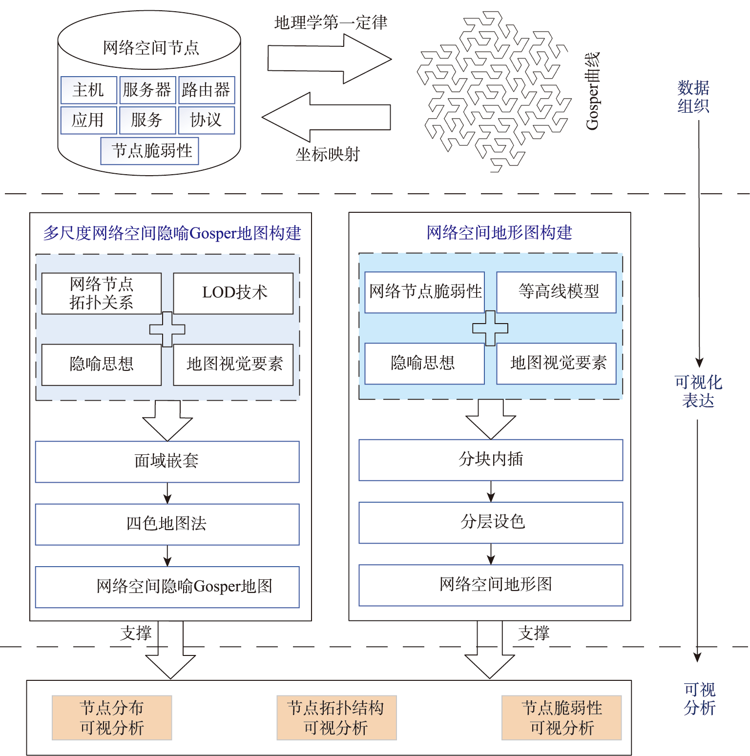
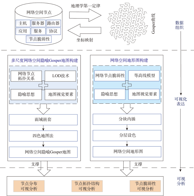
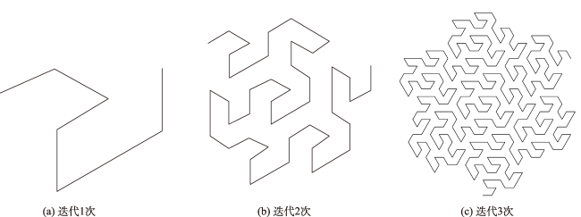
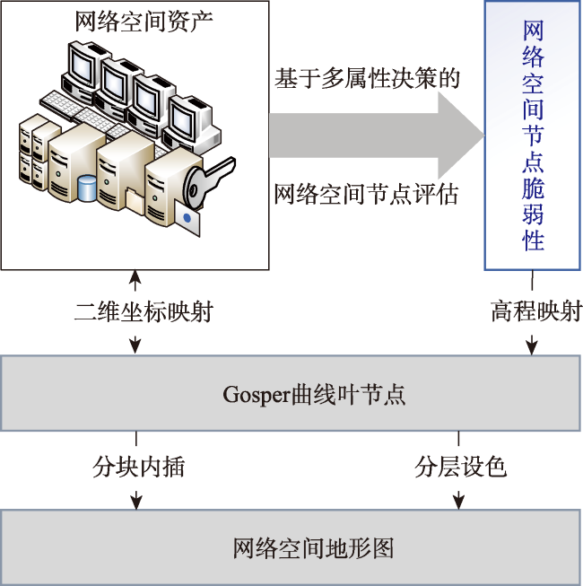
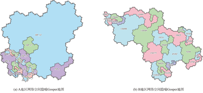
网络空间地图是认识抽象、复杂网络空间的重要工具,也是地图学领域研究的新方向和热点问题。针对传统网络空间制图不能分析网络节点多级拓扑关系和存在要素重叠的问题,本文综合应用隐喻思想和Gosper地图技术研究网络空间要素的隐喻表达与分析,提出了网络空间隐喻Gosper地图和地形图构建方法。首先,结合网络空间节点的拓扑层级关系和地理学第一定律构建网络节点与Gosper曲线叶节点的映射关系;然后,基于Gosper叶节点构建具有面域嵌套关系的Gosper地图;最后,结合隐喻思想和地图视觉要素与网络空间要素的相似性关系构建多尺度网络空间隐喻Gosper地图和地形图。本文基于两套网络空间资产数据验证了本文方法的适用性,并从节点分布、拓扑结构和节点脆弱性3个方面分析和挖掘网络空间资产特性用以说明网络空间隐喻Gosper地图的表达能力与认知效果。基于层次分析法的定量实验表明,本文方法的综合加权指标(0.499 8)远高于节点链接(0.266 8)和地理空间图层叠加(0.233 1)可视化方法。本文提出的网络空间隐喻地图能够有效解决传统网络空间可视化中节点重复冗余、复杂抽象且无法支撑可视化分析的问题,能够为感知和管理网络资产、挖掘网络空间数据,可视化分析网络空间提供理论和手段支撑。
刘龙辉 , 施群山 , 周杨 , 胡校飞 , 徐青 . 网络空间隐喻Gosper地图表达与分析[J]. 地球信息科学学报, 2024 , 26(1) : 144 -157 . DOI: 10.12082/dqxxkx.2024.230640
In recent years, with the continuous expansion and deepening of human geospatial awareness, cyberspace has become a new dimension of human life. Cyberspace is an inevitable product of the development of the Internet and information technology, a deepening and expansion of human geospatial awareness, and a new frontier that affects national security. It has become the fifth dimension of space that countries are concerned about. The cyberspace map is an important tool for understanding abstract and complex cyberspace, and it is also a new research direction and hot topic in the field of cartography. In view of the current problems in network space visualization technology, such as the inability of node-link visualization methods and geographical space layer overlay visualization methods to analyze multi-level topological relationships of network space nodes, as well as the overlap of elements in the above methods, this article comprehensively applies metaphorical thinking, Gosper map technology, and Level of Detail technology to study the metaphorical expression and analysis of network space elements, and proposes a method for constructing cyberspace metaphorical Gosper maps and topographic maps. This article first reviews the current research status of cyberspace map visualization, points out the problems in cyberspace visualization. Then, it describes the methodological principles of expressing network space elements based on metaphorical thinking. Secondly, this article proposes a method for constructing cyberspace maps and topographic maps. That is, firstly, combining the topological hierarchical relationships of network space nodes with the first law of geography to construct a mapping relationship between network nodes and Gosper curve leaf nodes. Then, based on Gosper leaf nodes, a Gosper map with nested face domains is constructed. Finally, combining metaphorical thinking with the similarity relationship between map visual elements and network space elements, multi-scale cyberspace metaphorical Gosper maps and topographic maps are constructed. Finally, based on two sets of network space asset data, we carry out construction experiments on cyberspace metaphorical Gosper maps and topographic maps, verifying the effectiveness of the proposed method. At the same time, we design quantitative analysis experiments for evaluating three visualization methods based on the Analytic Hierarchy Process (AHP). We analyze and mine the characteristics of network space assets from three aspects: network space node distribution, topological structure analysis, and critical terrain analysis. These characteristics are used to demonstrate the expressiveness and cognitive effectiveness of cyberspace metaphorical Gosper maps. Quantitatively speaking, our method outperforms the other two visualization methods in all five evaluation indicators.
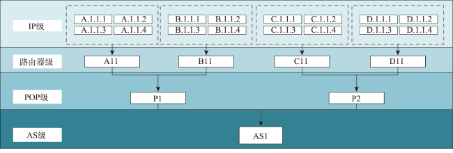
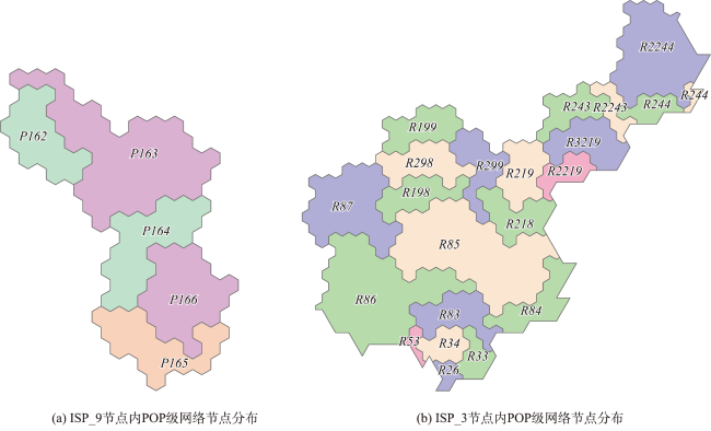
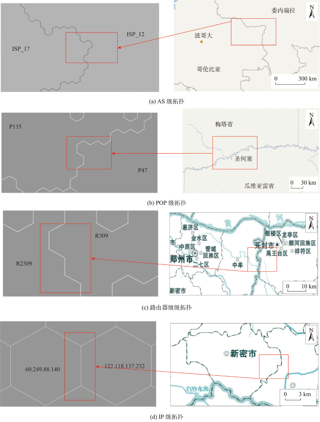
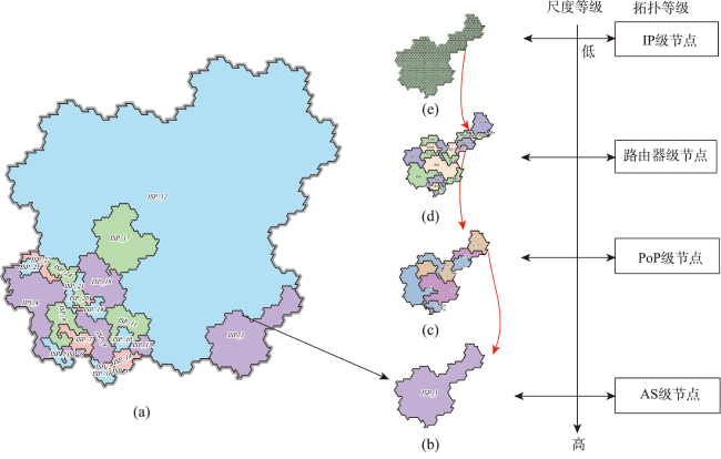
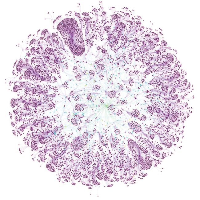
图9 地图分界线转义表达网络空间节点拓扑结构注: IP (Internet Protocol)为协议级, POP (Point of Presence)为接人点级, AS (autonomous system)为自治域级。 图9(c)-9(d)底图引自河南省标准地图-行政版( https://henan.tianditu.gov.cn/standardMap )。 Fig. 9 Map boundary line transitive representation of cyberspace node topology |
表1 基于层次分析法的3种可视化方法的评估结果Tab. 1 Evaluation results of three visualization methods based on analytic hierarchy process |
| 可视化方法 | 视觉呈现的直观性 | 视觉呈现的易读性 | 信息传达的深度 | 信息传达的广度 | 信息传达的准确性 |
|---|---|---|---|---|---|
| 隐喻Gosper地图 | 0.504 0 | 0.490 8 | 0.505 3 | 0.502 4 | 0.503 1 |
| 节点链接法 | 0.255 2 | 0.284 0 | 0.268 4 | 0.295 1 | 0.247 7 |
| 地理空间图层叠加法 | 0.240 8 | 0.225 2 | 0.226 2 | 0.202 5 | 0.249 2 |
注:加粗为本文方法评估结果。 |
表2 3种网络空间可视化方法的综合加权结果Tab. 2 Comprehensive weighted results of three cyberspace visualization methods |
| 可视化方法 | 加权指标 |
|---|---|
| 隐喻Gosper地图 | 0.499 8 |
| 节点链接法 | 0.266 8 |
| 地理空间图层叠加法 | 0.233 1 |
注:加粗为本文方法评估结果。 |
| [1] |
|
| [2] |
数世咨询. 网络空间资产测绘(CAM)能力指南[EB/OL].[2024-1-30]. https://www.dwcon.cn/post/568.
[Digital world consulting. A guide to mapping capability of cyberspace assets (CAM)[EB/OL].[2024-1-30]. https://www.dwcon.cn/post/568.]
|
| [3] |
王继龙, 庄姝颖, 缪葱葱, 等. 网络空间信息系统模型与应用[J]. 通信学报, 2020, 41(2):74-83.
[
|
| [4] |
周杨, 徐青, 罗向阳, 等. 网络空间测绘的概念及其技术体系的研究[J]. 计算机科学, 2018, 45(5):1-7.
[
|
| [5] |
李响, 杨飞, 王丽娜, 等. 网络空间地图制图方法研究综述[J]. 测绘科学技术学报, 2019, 36(6):620-626,631.
[
|
| [6] |
张峥. 赛博地图构建理论研究[D]. 解放军信息工程大学, 2012.
[
|
| [7] |
张龙. 网络资源测绘数据表达与分析技术研究[D]. 战略支援部队信息工程大学, 2018.
[
|
| [8] |
张龙, 周杨, 施群山, 等. 与地理空间紧关联的网络空间地图模型[J]. 信息安全学报, 2018, 3(4):63-72.
[
|
| [9] |
王续盘, 张衡, 周杨, 等. Blondel和k-核分解混合算法相结合的网络空间点群要素多尺度模型构建[J]. 地球信息科学学报, 2021, 23(12):2128-2138.
[
|
| [10] |
Telegeography. Global Internet Map 2021. [EB/OL]. [2024-1-30]. https://global-internet-map-2021.telegeography.com/
|
| [11] |
王映雪, 李少梅, 张鑫禄. 基于复合距离Cartogram的网络空间信息地图可视化方法[J]. 信息工程大学学报, 2020, 21(3):334-339,360.
[
|
| [12] |
Google. The Internet Map. [EB/OL]. [2024-1-30]. http://internet-map.net/
|
| [13] |
|
| [14] |
蒋秉川, 万刚, 徐锐. 网络空间剖分机理与可视化方法研究[J]. 系统仿真学报, 2017, 29(S1):1-8.
[
|
| [15] |
陈云海. 社交网络空间时空实体建模与可视化研究[D]. 战略支援部队信息工程大学, 2022.
[
|
| [16] |
原雅姣, 王亮, 肖新光. 网络靶场可视化技术的研究与实现[J]. 保密科学技术, 2021, 129(6):43-52.
[
|
| [17] |
刘玉华, 翟如钰, 张翔, 等. 知识图谱可视分析研究综述[J]. 计算机辅助设计与图形学学报, 2023, 35(1):23-36.
[
|
| [18] |
|
| [19] |
苏世亮, 王令琦, 杜清运, 等. 隐喻地图的基本理论问题[J/OL]. 地球信息科学学报, 2022:1-13.(2022-12-29).
[
|
| [20] |
艾廷华. 大数据驱动下的地图学发展[J]. 测绘地理信息, 2016, 41(2):1-7.
[
|
| [21] |
信睿, 艾廷华, 何亚坤. Gosper地图的非空间层次数据隐喻表达与分析[J]. 测绘学报, 2017, 46(12):2006-2015.
[
|
| [22] |
|
| [23] |
崔珂成, 马晓悦, 薛鹏珍. 基于隐喻地图的社交媒体用户应急物资需求可视化分析[J]. 现代情报, 2021, 41(7):27-37.
[
|
| [24] |
艾廷华, 周梦杰, 陈亚婕. 专题地图属性信息的LOD表达与TreeMap可视化[J]. 测绘学报, 2013, 42(3):453-460.
[
|
| [25] |
|
| [26] |
信睿, 艾廷华. Gosper曲线支持的正六边形栅格数据游程编码及高效压缩[J]. 测绘学报, 2019, 48(2):226-237.
[
|
| [27] |
|
| [28] |
杨慧, 李春林, 孙治, 等. 互联网拓扑数据获取方法研究综述[J]. 通信技术, 2019, 52(8):1811-1817.
[
|
| [29] |
江东, 高春东, 郭启全, 等. 论网络空间的地理属性与地理学思维[J/OL]. 地球信息科学学报, 2023:1-10.(2023-03-07).https://kns.cnki.net/kcms/detail/11.5809.P.20230306.1138.004.html
[
|
| [30] |
肖坤, 艾廷华, 王璐. 正六边形格网DEM下的等高线生成算法及质量评价[J]. 地球信息科学学报, 2022, 24(4):643-656.
[
|
| [31] |
Joint Publication 3-12 (R): Cyberspace Operations. Cyberspace Operations. Federation of American scientists[EB/OL]. [2024-1-30]. https://irp.fas.org/doddir/dod/jp3_12r.pdf
|
| [32] |
|
| [33] |
|
| [34] |
|
| [35] |
陈国良, 曹卫群, 黄心渊. 一种由等高线模型生成规则格网模型的算法[J]. 中国图象图形学报, 2007, 12(6):1110-1113.
[
|
| [36] |
蔡莉, 李永轩, 王淑婷, 等. 基于层次分析法的众源地理数据质量评估研究[J]. 测绘地理信息, 2021, 46(3):98-102.
[
|
| [37] |
段晓旗, 刘涛, 武丹. 基于层次分析法的多尺度点群目标相似度计算[J]. 地球信息科学学报, 2016, 18(10):1312-1321.
[
|
/
| 〈 |
|
〉 |