
顾及全生命周期的国际大洋钻探科学数据模型构建与管理服务方法研究
|
孙昊阳(1998— ),男,江苏南京人,博士生,主要从事地质数据治理研究。E-mail: shy_gis@njnu.edu.cn |
Copy editor: 蒋树芳
收稿日期: 2023-07-01
修回日期: 2023-12-11
网络出版日期: 2024-03-31
基金资助
国家自然科学基金项目(42371464)
江苏省研究生科研与实践创新计划项目(KYCX23_1709)
Research on Data Model Construction and Management Service Methods for Scientific Ocean Drilling Considering the Whole Lifecycle
Received date: 2023-07-01
Revised date: 2023-12-11
Online published: 2024-03-31
Supported by
National Natural Science Foundation of China(42371464)
Postgraduate Research & Practice Innovation Program of Jiangsu Province(KYCX23_1709)
国际大洋钻探计划是地球科学中规模巨大、历时长久的国际合作项目,其数据具有来源复杂、存储分散、格式多样等特征。现有岩芯、测井、文献等数据库平台建设较早,数据组织不统一、检索条件单一、分析应用困难,缺少集成且多样的可视化及分析工具,不利于数据的统一管理、有效整合、高效调度、广泛共享和综合利用。针对上述问题,论文首先剖析了全生命周期的国际大洋钻探科学数据产生流程和组织形式,并分析国际大洋钻探数据要素分类和描述体系,构建了顾及全生命周期的国际大洋钻探科学数据模型,在此基础上,提出包含数据组织、数据查询和专题制图的国际大洋钻探科学数据整合和服务应用框架,设计基于弹性搜索引擎数据冷热分离的数据存储、基于要素按需整合思想的数据查询和可定制可配置的钻孔数据专题制图方法,最后开展了在线验证平台研发实践。研究结果表明,本数据模型及应用框架具备支持数据统一存储、多要素查询和灵活制图等能力和特点,可为科学大数据的高效管理和应用提供借鉴。

孙昊阳 , 林冰仙 , 周良辰 , 闾国年 . 顾及全生命周期的国际大洋钻探科学数据模型构建与管理服务方法研究[J]. 地球信息科学学报, 2024 , 26(3) : 638 -653 . DOI: 10.12082/dqxxkx.2024.230361
Scientific Ocean Drilling is a large-scale and long-standing international collaborative project in Earth sciences. Over the past 50 years, the program has carried out more than 300 expeditions and acquired a large amount of scientific data. The data exhibit typical characteristics of big scientific data, such as complex sources, diverse storage formats, and varied data structures. Currently, earth science has entered the fourth paradigm of data-driven scientific discovery. Effective organization and management of data, as well as enhanced data integration and services, are important foundational requirements for utilizing scientific ocean drilling data for data-driven Earth science discoveries. Existing scientific ocean drilling databases were established at an early stage, featuring relatively simple data retrieval capabilities and a lack of integrated and diverse data-processing tools. This poses challenges to the unified management, effective integration, efficient scheduling, extensive sharing, and comprehensive utilization of data. In response to these problems, firstly, the issues and requirements of scientific ocean drilling data organization and modeling are thoroughly analyzed. The process of generating scientific ocean drilling data, considering the whole lifecycle, was analyzed for organizing multi-source heterogeneous data. Then, based on the information expression system with elements of time, place, character, object, event, phenomenon, and scene, dimensions of semantic, spatial location, geometric structure, attribute, interrelationship, evolution process, and mechanism of interpretation from the perspective of geography, a scientific ocean drilling data model was constructed, taking into account the entire lifecycle of drilling data. Building upon this foundation, a framework for the scientific ocean drilling data integration and service application was proposed, encompassing data management, data querying, and thematic mapping. To optimize storage space and improve query efficiency, the storage implementation based on object-relational database and Elasticsearch was completed, following the concept of data cold-hot separation. To meet diversified data acquisition needs, a data retrieval approach with elemental on-demand query and multi-modal result integration was proposed. To better visualize the data, a customizable and configurable thematic mapping method was implemented. Based on these methods, a verification platform with the aforementioned capabilities was developed. The scientific ocean drilling data of Exp349, Exp367, and Exp368 in the South China Sea were used as examples to validate the feasibility of the methods and the usability of the platform. The research findings provide methodological references for organizing scientific ocean drilling data and serve as a reference for the efficient management and application of big scientific data.

表1 本平台与现有数据库平台的数据组织、查询和展示能力对比Tab. 1 Comparison of data organization, query and presentation capabilities between platforms |
| 能力分析 | 能力对比 | |||||||
|---|---|---|---|---|---|---|---|---|
| Ⅰ | Ⅱ | Ⅲ | Ⅳ | Ⅴ | Ⅵ | |||
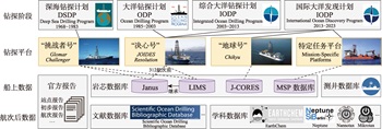
| 数据组织 | Ⅰ 提供由“决心号”钻探平台获取的岩芯数据,以数据库形式组织,以312航次为界,存在2种数据组织形式 Ⅱ 提供由“地球号”钻探平台获取的岩芯数据,以文件形式组织,内容不如LIMS完备 Ⅲ 提供特定任务平台获取的岩芯数据,对沉积学、古生物学等学科的数据组织更为完备 Ⅳ 提供部分开展测井工作的站位测井数据 Ⅴ 以元数据的形式对不同数据库间数据进行关联,但数据内容和精度相对较低 Ⅵ 数据模型能够支持不同平台、不同平台的钻井、测井与录井等数据的组织,具有较强的拓展能力。但有待进行数据的汇编 | □ | △ | △ | △ | □ | ○ | |
| 查询方式 | Ⅰ 按数据类型与航次号、钻孔号、岩芯段等信息组合检索 Ⅱ 按航次号进行检索,不支持数据类型检索 Ⅲ 按钻孔号、数据类型、时间等组合检索 Ⅳ 按项目号、航次号、钻孔号、所属大洋、数据类型等检索 Ⅴ 按航次号、钻孔号、所属大洋、坐标范围等检索,支持自然语言查询与地图空间查询 Ⅵ 支持自然语言查询、地图空间查询、时间轴选择、航次信息查询,支持对属性进行复合条件检索,支持多模式条件的整合 | □ | △ | △ | □ | ○ | ○ | |
| 展示形式 | Ⅰ 以列表的形式提供预览,并支持数据文件下载,提供在线数据图形化可视能力,但支持模板有限 Ⅱ 以文件形式提供数据下载 Ⅲ 以列表的形式提供预览,并支持数据文件下载,以地图形式对钻孔点位进行展示 Ⅳ 以文件形式提供数据下载 Ⅴ 以文件形式提供数据下载 Ⅵ 以地图形式展示钻孔位置,以列表形式展示钻井数据与岩芯数据,以三维钻孔模型展示地层分布,以知识图谱展示关联关系,以可定制可配置的岩芯图进行图形化展示 | □ | △ | □ | △ | △ | ○ | |
注:代号与数据库平台的对应关系:Ⅰ—LIMS、Ⅱ—J-CORES、Ⅲ—MSP数据库、Ⅳ—测井数据库、Ⅴ—SEDIS、Ⅵ—本平台;能力对比的符号含义:○—完备/丰富;□—较完备/较丰富;△—中等。 |
本研究获得“深时数字地球”(Deep-time Digital Earth, DDE)国际大科学计划的支持。
| [1] |
汪品先. 大洋钻探五十年:回顾与前瞻[J]. 科学通报, 2018, 63(36):3868-3876.
[
|
| [2] |
IODP International Ocean Discovery Program. IODP Expedition Statistics[EB/OL]. [2023.06.01]. https://iodp.org/expeditions/expedition-statistics.
|
| [3] |
马鹏飞, 刘志飞, 拓守廷, 等. 国际大洋钻探科学数据的现状、特征及其汇编的科学意义[J]. 地球科学进展, 2021, 36(6):643-662.
[
|
| [4] |
|
| [5] |
|
| [6] |
鲁铮博, 史宇坤, 华洪, 等. 国际大洋科学钻探的数据资源与共享现状[J]. 高校地质学报, 2020, 26(4):472-480.
[
|
| [7] |
American Geosciences Institute. Scientific Ocean Drilling Bibliographic Database[DB/OL].[2023-06-01].http://iodp.americangeosciences.org/vufind/
|
| [8] |
|
| [9] |
|
| [10] |
|
| [11] |
周成虎, 王华, 王成善, 等. 大数据时代的地学知识图谱研究[J]. 中国科学:地球科学, 2021, 51(7):1070-1079.
[
|
| [12] |
|
| [13] |
华一新, 赵鑫科, 张江水. 地理信息系统研究新范式[J]. 地球信息科学学报, 2023, 25(1):15-24.
[
|
| [14] |
|
| [15] |
杨雅萍, 姜侯, 孙九林. 科学数据共享实践:以国家地球系统科学数据中心为例[J]. 地球信息科学学报, 2020, 22(6):1358-1369.
[
|
| [16] |
|
| [17] |
|
| [18] |
SEDIS, Scientific Earth Drilling Information[DB/OL]. [2023-06-01]. http://sedis.iodp.org/.
|
| [19] |
|
| [20] |
华一新, 张江水, 曹一冰. 基于时空域的全空间数字世界时空对象组织与管理研究[J]. 地球信息科学学报, 2021, 23(1):76-83.
[
|
| [21] |
龚健雅. GIS中面向对象时空数据模型[J]. 测绘学报, 1997, 26(4):289-298.
[
|
| [22] |
龚健雅, 李小龙, 吴华意. 实时GIS时空数据模型[J]. 测绘学报, 2014, 43(3):226-232,275.
[
|
| [23] |
李新, 郑东海, 冯敏, 等. 信息地理学:信息革命重塑地理学[J]. 中国科学:地球科学, 2022, 52(2):370-373.
[
|
| [24] |
闾国年, 袁林旺, 俞肇元. 信息地理学:地理三元世界的新支点[J]. 中国科学:地球科学, 2022, 52(2):374-376.
[
|
| [25] |
周成虎. 全空间地理信息系统展望[J]. 地理科学进展, 2015, 34(2):129-131.
[
|
| [26] |
华一新, 周成虎. 面向全空间信息系统的多粒度时空对象数据模型描述框架[J]. 地球信息科学学报, 2017, 19(9):1142-1149.
[
|
| [27] |
王健健, 王艳楠, 周良辰, 等. 多粒度时空对象关联关系的分类体系与表达模型[J]. 地球信息科学学报, 2017, 19(9):1164-1170.
[
|
| [28] |
闾国年, 俞肇元, 袁林旺, 等. 地图学的未来是场景学吗?[J]. 地球信息科学学报, 2018, 20(1):1-6.
[
|
| [29] |
|
| [30] |
|
| [31] |
俞肇元, 袁林旺, 吴明光, 等. 地理学视角下地理信息的分类与描述[J]. 地球信息科学学报, 2022, 24(1):17-24.
[
|
| [32] |
|
| [33] |
孙超, 肖文名, 曾乐, 等. 海量监视数据云存储服务模型的设计与实现[J]. 武汉大学学报(信息科学版), 2020, 45(7):1099-1106.
[
|
| [34] |
王灿辉, 张敏, 马少平. 自然语言处理在信息检索中的应用综述[J]. 中文信息学报, 2007, 21(2):35-45.
[
|
| [35] |
|
| [36] |
张驰, 李安波, 周良辰. 通用钻孔柱状图模型研究[J]. 测绘科学, 2012, 37(6):122-124.
[
|
| [37] |
|
| [38] |
|
| [39] |
|
| [40] |
JOIDES Resolution Science Operator. Laboratory Information Management System[DB/OL].[2023-06-01]. https://web.iodp.tamu.edu/OVERVIEW/.
|
| [41] |
|
| [42] |
|
/
| 〈 |
|
〉 |