
基于多视角二维投影的实景三维模型解译
|
曲俸磊(1999— ),男,山东德州人,硕士生,主要从事实景三维模型语义解译方法研究。E-mail: qufenglei2021@email.szu.edu.cn |
Copy editor: 蒋树芳
收稿日期: 2023-09-02
修回日期: 2023-10-20
网络出版日期: 2024-03-31
基金资助
国家自然科学基金项目(41871227)
深圳市科技计划资助(JCYJ20220818101617037)
深圳市科技计划资助(JCYJ20230808105201004)
Classification of Textured 3D Mesh Models Based on Multiview 2D Mapping
Received date: 2023-09-02
Revised date: 2023-10-20
Online published: 2024-03-31
Supported by
National Natural Science Foundation of China(41871227)
Shenzhen Science and Technology Program(JCYJ20220818101617037)
Shenzhen Science and Technology Program(JCYJ20230808105201004)
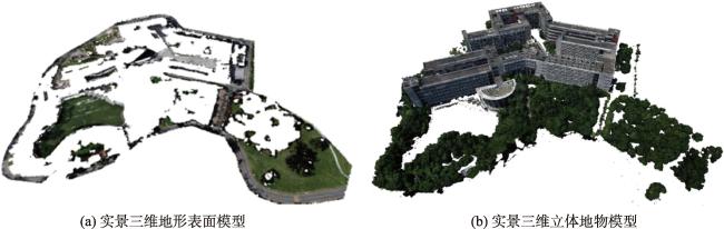
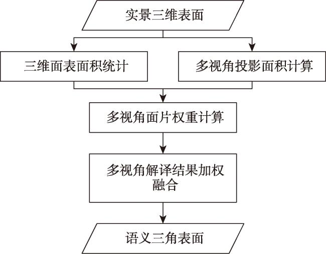
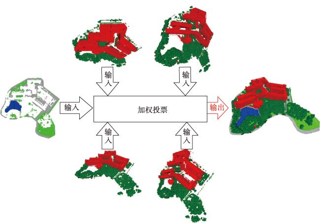
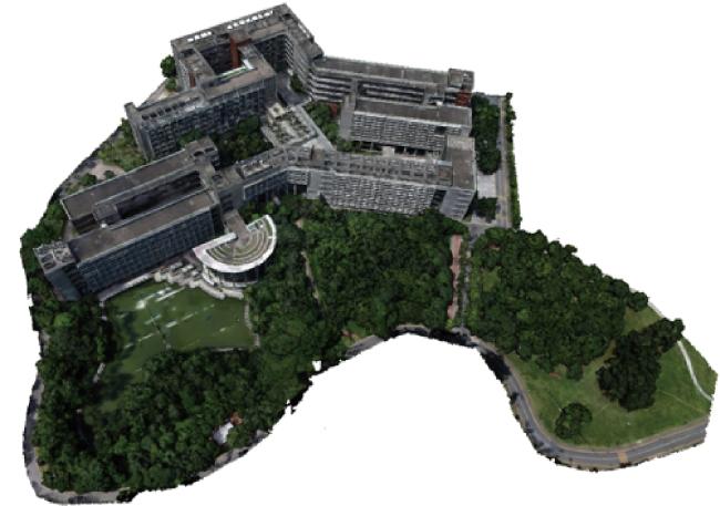
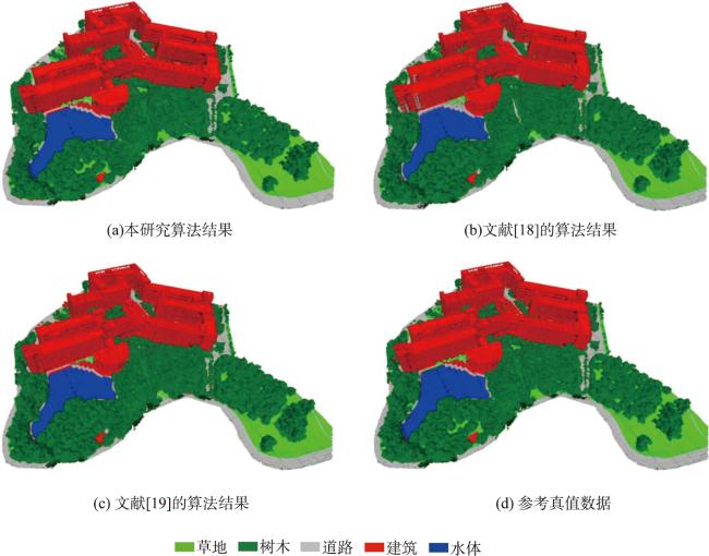
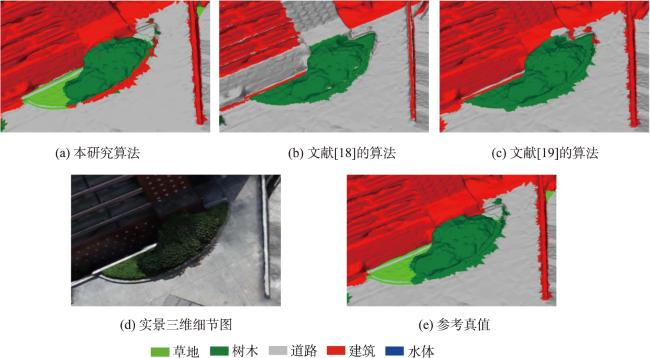
实景三维是对人类生产、生活和生态空间进行真实、立体化反映和表达的数字虚拟空间,已作为基础数据广泛应用于智慧城市、可视化展览等领域。实景三维模型语义解译是充分发掘实景三维模型的数据价值以实现场景的自动理解与分析的基础。已有的三维解译方法中,存在被遮挡地物解译不完全,不同地物边界解译不准确等问题。针对该问题,本研究提出了一种基于多视角的实景三维模型解译方法。该方法首先模拟成像过程实现实景三维的多视角二维投影,进一步基于二维影像解译快速获取语义信息,最后将多个二维解译结果进行逆投影获得三维语义模型。本研究以深圳大学实景三维模型为实验数据,通过与基于正射影像的三维解译、面向对象的三维分层解译等方法对比,验证本文所提方法的有效性。结果显示本研究提出的基于多视角的解译方法获得了最高的分类精度(总体分类精度为96.69%, Kappa系数为0.942),在正射遮挡区域,以及不同地物边界区域有更好的解译效果。本方法充分利用实景三维数据的多角度信息,具有较高的理论和实践参考价值,为进一步促进实景三维建设及在自然资源监测领域的应用提供了方法支撑。
曲俸磊 , 胡忠文 , 张英慧 , 张金华 , 邬国锋 . 基于多视角二维投影的实景三维模型解译[J]. 地球信息科学学报, 2024 , 26(3) : 654 -665 . DOI: 10.12082/dgxxkx.2024.230520
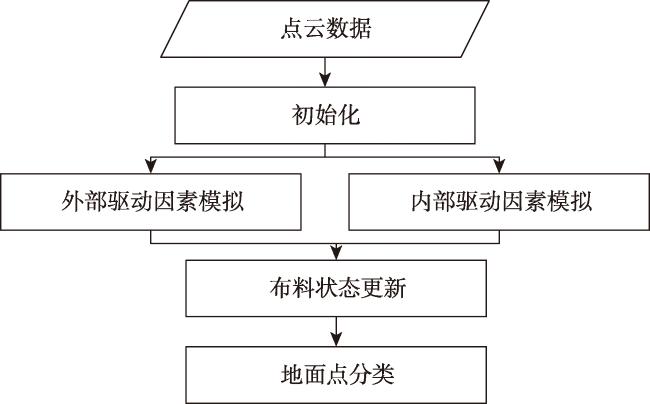
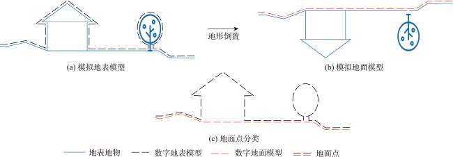
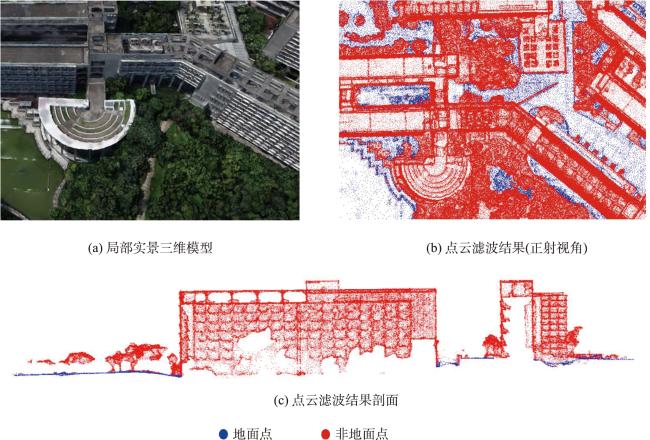
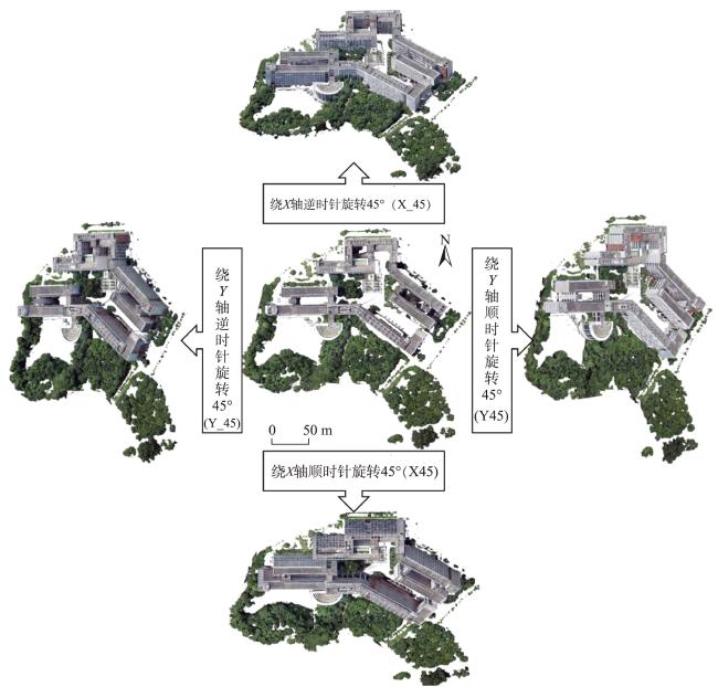
Textured 3D mesh models are digital virtual spaces that provide a true, three-dimensional representation of human production, living, and ecological spaces. They have been widely used as foundational data input in areas such as smart cities and visual exhibitions. The semantic interpretation of textured 3D models is the foundation for fully exploring the potential of these models to achieve automatic understanding and analysis of scenes. Existing interpretation methods suffer from issues such as incomplete interpretation of occluded objects and inaccurate interpretation of different object boundaries. To address these challenges, in this study, we propose a multiview-based classification method for textured 3D mesh models. A textured 3D mesh model is first segmented into ground surfaces and 3D objects by Cloth Simulation Filtering (CSF) method. The ground surface is projected to a 2D orthophoto and classified using object-based image analysis methods. The textured 3D objects are transformed into five 2D images through orthographic and multiview oblique projections. These 2D images are then classified using object-based image analysis methods. Furthermore, these 2D semantic maps are inverse-projected to the 3D mesh model, and a multiview voting strategy is proposed for fusing sematic information from different views to obtain the sematic 3D objects. Finally, the semantic terrain surface and 3D objects are merged together to obtain the semantic 3D mesh model. A textured 3D mesh model of Shenzhen University is used to verify the effectiveness of the proposed method. Besides, the proposed method is compared with two state-of-the-art methods. The results show that the proposed method effectively addresses the problems in interpreting occluded objects and distinguishing edges between different objects. It outperforms the competing methods, particularly in the areas of orthographic occlusion and where different ground objects are connected or adhered, and achieves the highest classification accuracy (overall accuracy is 96.69%, Kappa coefficient is 0.942). Future research endeavors could consider the introduction of hyper-facet as the basic unit for classification and multiview fusion. Besides, we used only five fixed views in this study, and adaptive multiview estimation strategy could be further investigated to enhance the accuracy and robustness of the method. This method makes full use of the multiview information of the textured 3D mesh models, which holds significant theoretical and practical values. It not only contributes valuable insights but also offers methodological support for advancing the development and utilization of textured 3D models, especially in the field of natural resources management using textured 3D mesh models.
表1 本文算法混淆矩阵Tab. 1 The confusion matrix of proposed method |
| 类别 | 参照样本(三角面片)/个 | 用户精度/% | 生产者精度/% | ||||
|---|---|---|---|---|---|---|---|
| 树木 | 建筑 | 草地 | 道路 | 水体 | |||
| 树木 | 1 016 152 | 28 429 | 26 | 59 | 0 | 97.27 | 95.75 |
| 建筑 | 36 046 | 1 123 208 | 18 | 113 | 0 | 96.88 | 97.07 |
| 草地 | 5 571 | 1 058 | 65 763 | 37 | 0 | 90.80 | 99.83 |
| 道路 | 3 182 | 4 328 | 66 | 105 467 | 1 | 93.30 | 99.79 |
| 水体 | 291 | 112 | 0 | 17 | 8 539 | 95.31 | 99.99 |
| 总体精度/% | 96.69 | ||||||
| Kappa 系数 | 0.942 | ||||||
| 类别 | 参照样本(三角面片)/个 | 用户精度/% | 生产者精度/% | ||||
|---|---|---|---|---|---|---|---|
| 树木 | 建筑 | 草地 | 道路 | 水体 | |||
| 树木 | 960 377 | 22 426 | 37 008 | 19 451 | 1 378 | 92.29 | 90.50 |
| 建筑 | 55 842 | 1 071 502 | 2 055 | 6 797 | 38 | 94.30 | 92.60 |
| 草地 | 13 542 | 4 598 | 22 045 | 1 964 | 0 | 52.30 | 33.47 |
| 道路 | 30 714 | 58 582 | 4 765 | 77 434 | 707 | 44.97 | 73.26 |
| 水体 | 767 | 27 | 0 | 47 | 6 417 | 88.41 | 75.14 |
| 总体精度/% | 89.13 | ||||||
| Kappa 系数 | 0.811 | ||||||
| 类别 | 参照样本(三角面片)/个 | 用户精度/% | 生产者精度/% | ||||
|---|---|---|---|---|---|---|---|
| 树木 | 建筑 | 草地 | 道路 | 水体 | |||
| 树木 | 949 888 | 3 819 | 684 | 398 | 8 | 99.49 | 89.51 |
| 建筑 | 108 271 | 1 149 114 | 907 | 2 561 | 69 | 91.13 | 99.31 |
| 草地 | 2 659 | 1 706 | 63 594 | 696 | 30 | 92.59 | 96.54 |
| 道路 | 381 | 2 447 | 638 | 101 924 | 81 | 96.64 | 96.43 |
| 水体 | 43 | 49 | 50 | 114 | 8 352 | 97.03 | 97.80 |
| 总体精度/% | 94.76 | ||||||
| Kappa 系数 | 0.908 | ||||||
| [1] |
李德仁, 张洪云, 金文杰. 新基建时代地球空间信息学的使命[J]. 武汉大学学报(信息科学版), 2022, 47(10):1515-1522.
[
|
| [2] |
朱勇, 程海翔. 基于倾斜摄影技术的城市实景三维建模研究[J]. 经纬天地, 2022(6):27-30.
[
|
| [3] |
曲林, 冯洋, 支玲美, 等. 基于无人机倾斜摄影数据的实景三维建模研究[J]. 测绘与空间地理信息, 2015, 38(3):38-39,43.
[
|
| [4] |
杨秀德. 基于语义描述的马尔科夫随机场无人机影像三维重建[J]. 北京测绘, 2018, 32(7):814-818.
[
|
| [5] |
|
| [6] |
|
| [7] |
|
| [8] |
|
| [9] |
|
| [10] |
|
| [11] |
|
| [12] |
|
| [13] |
|
| [14] |
黄印. 基于傅里叶变换的倾斜三维模型建筑物分层提取方法[D]. 武汉: 武汉大学, 2018.
[
|
| [15] |
郭慧婷. 基于拓扑结构的三维模型特征提取方法研究[D]. 太原:中北大学, 2017. [
|
| [16] |
|
| [17] |
|
| [18] |
|
| [19] |
刘志刚, 胡忠文, 黄乐平, 等. 面向对象的实景三维模型分层解译方法研究[J]. 地理信息世界, 2022, 29(1):28-34.
[
|
| [20] |
|
| [21] |
|
| [22] |
|
| [23] |
|
/
| 〈 |
|
〉 |

