
基于无人机遥感的盐渍化土壤有机质反演方法研究
|
王玮莹(1998— ),女,山东德州人,硕士,研究方向为农业遥感与农业生态。E-mail: wangwy.20s@igsnrr.ac.cn |
Copy editor: 蒋树芳
收稿日期: 2023-05-14
修回日期: 2023-09-24
网络出版日期: 2024-03-31
基金资助
国家重点研发计划项目(2021YFD1900902)
中国科学院A类战略性先导科技专项(XDA23050102)
国家自然科学基金面上项目(42271349)
国家自然科学基金创新研究群体科学基金(72221002)
泰山产业领军人才工程资助。
Study on Retrieval Method of Soil Organic Matter in Salinity Soil Using Unmanned Aerial Vehicle Remote Sensing
Received date: 2023-05-14
Revised date: 2023-09-24
Online published: 2024-03-31
Supported by
National Key Research and Development Program of China(2021YFD1900902)
Strategic Priority Research Program of the Chinese Academy of Sciences(XDA23050102)
General Program of National Natural Science Foundation of China(42271349)
Science Fund for Creative Research Groups of the National Natural Science Foundation of China(72221002)
The Taishan Industrial Experts Program.
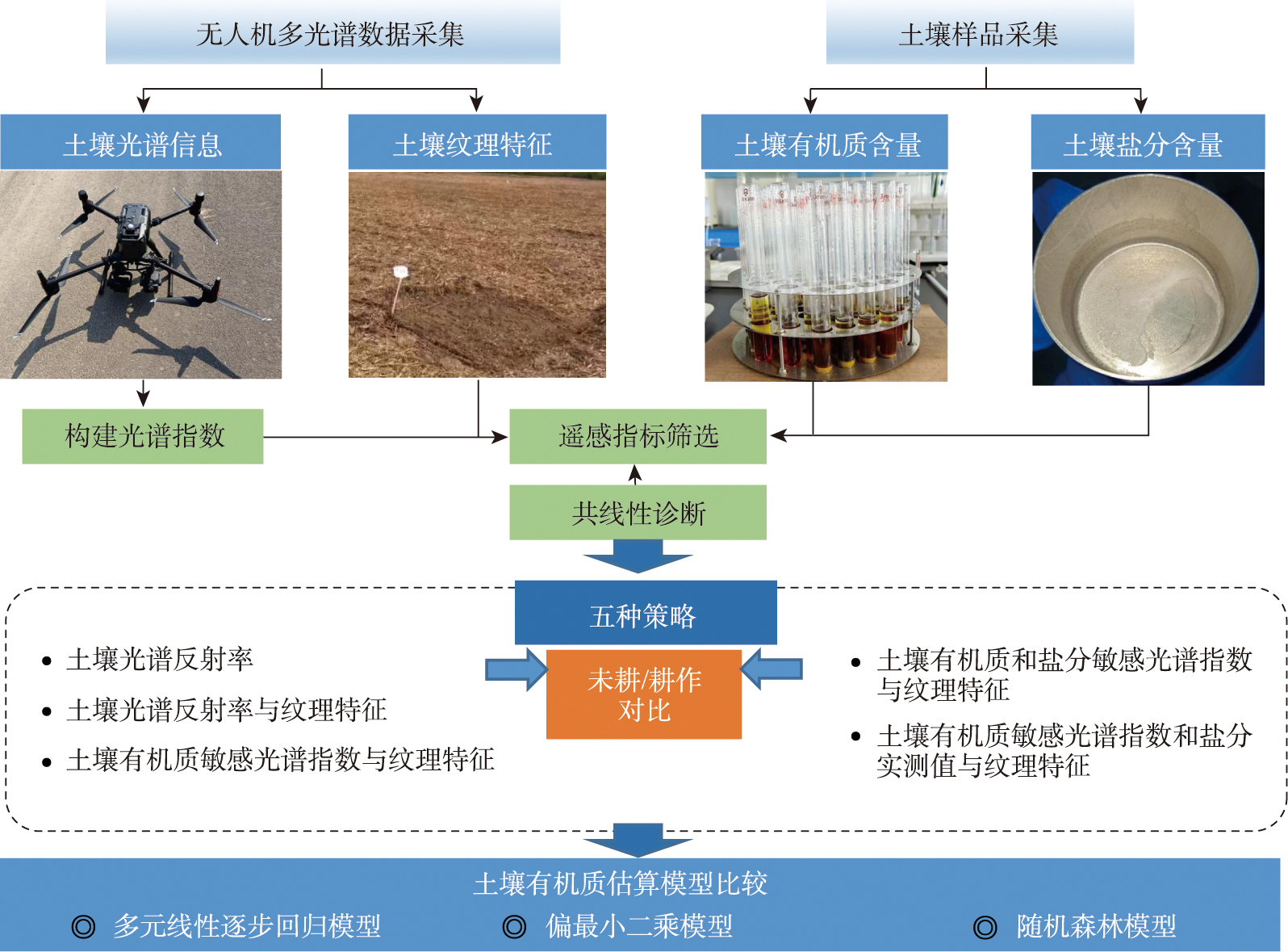
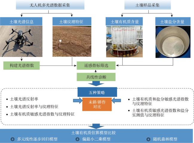
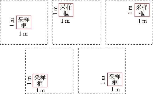
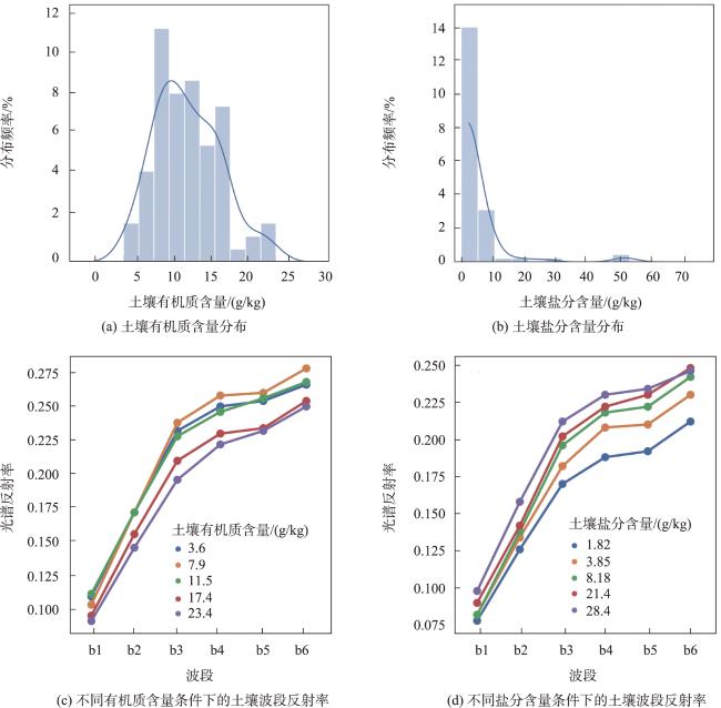
土壤有机质含量是衡量土壤肥力的重要指标,对粮食生产具有重要影响。我国滨海盐碱地分布广阔,土壤有机质呈现显著的空间异质性。传统的“实地采集-实验测量”的方法费时费力,难以快速描绘盐碱地区土壤有机质含量的空间分布特征。因此,采用遥感技术对土壤有机质含量进行高效且精准地反演,可以快速了解土壤肥力,从而调整与优化农业生产与管理。本研究以黄河三角洲典型滨海盐碱地裸土(0~10 cm土层)为研究对象,通过提取土壤的无人机遥感光谱与空间纹理信息,构建并筛选遥感指数。分别采用多元线性逐步回归、偏最小二乘以及随机森林模型对土壤有机质含量进行反演,并对比分析耕作与未耕作处理对反演的影响,同时探究融入对土壤盐分含量敏感的遥感信息是否可提高盐碱地区土壤有机质的反演精度。研究结果表明:① 在土壤有机质含量反演中,随机森林模型的反演精度(R2为0.83~0.95)显著高于多元线性逐步回归(R2为0.26~0.69)和偏最小二乘模型(R2为0.37~0.72);② 与未耕作土壤(R2为0.26~0.95)相比,耕作处理下的土壤有机质的反演精度较高(R2为0.54~0.94),即土壤的耕作处理能提高光谱指数对于土壤有机质含量的响应,从而提升土壤有机质含量的反演精度,为更加精准地监测土壤有机质提供新思路;③ 融入遥感纹理信息或土壤盐分含量信息(盐分实测值和盐分敏感指数)可显著提高土壤有机质反演精度。本研究将为提升田块尺度滨海盐渍化农田的土壤有机质含量反演提供理论与技术支撑,从而促进滨海盐渍化地区现代化农业的发展。
王玮莹 , 彭金榜 , 朱婉雪 , 杨斌 , 刘振 , 公华锐 , 王俊栋 , 杨婷 , 娄金勇 , 孙志刚 . 基于无人机遥感的盐渍化土壤有机质反演方法研究[J]. 地球信息科学学报, 2024 , 26(3) : 736 -752 . DOI: 10.12082/dqxxkx.2024.230267
Soil Organic Matter (SOM) content is an important indicator for measuring soil fertility and has a significant impact on food production. China's coastal saline-alkali lands are vast, and SOM exhibits significant spatial heterogeneity. The traditional method of “field collection and experimental measurement” is time-consuming and labor-intensive, making it difficult to quickly depict the spatial distribution characteristics of SOM content in saline-alkali areas. Therefore, efficiently and accurately using remote sensing technology to invert SOM content can provide insights into soil fertility, so as to help adjust and optimize agricultural production and management. This study focused on the bare soil (0~10 cm soil layer) in a typical coastal saline-alkali land of the Yellow River Delta and constructed remote sensing indices from the Unmanned Aerial Vehicle (UAV) remote sensing spectral and spatial texture information. The multi-linear stepwise regression model, partial least squares model, and random forest model were employed to quantitatively estimate SOM. We compared and analyzed the impact of cultivated and uncultivated soil on SOM content retrieval through UAV remote sensing methods, and also explored whether the integration of remote sensing information sensitive to soil salt content aids in SOM retrieval in saline-alkali areas. The results show that: (1) In the inversion of SOM content, the accuracy of random forest model (R2 ranging from 0.83 to 0.95) was significantly higher than that of multiple linear stepwise regression (R2 ranging from 0.26 to 0.69) and partial least squares model (R2 ranging from 0.37 to 0.72); (2) Compared to uncultivated soil (R2 ranging from 0.26 to 0.95), the inversion accuracy of organic matter in cultivated soil (R2 ranging from 0.54 to 0.94) was significantly higher. That is to say, cultivation treatment enhanced the response of spectral indices to SOM content, thereby increasing the inversion accuracy of SOM content, which provides new insights for precise monitoring of SOM; (3) Integrating remote sensing texture information or soil salt content information (i.e., salt content and salt sensitivity) can significantly increase the inversion accuracy of SOM. This study provides theoretical and technical support for improving SOM content inversion in salinized coastal farmland at the field scale, ultimately contributing to the development of modern agriculture in salinized coastal areas.
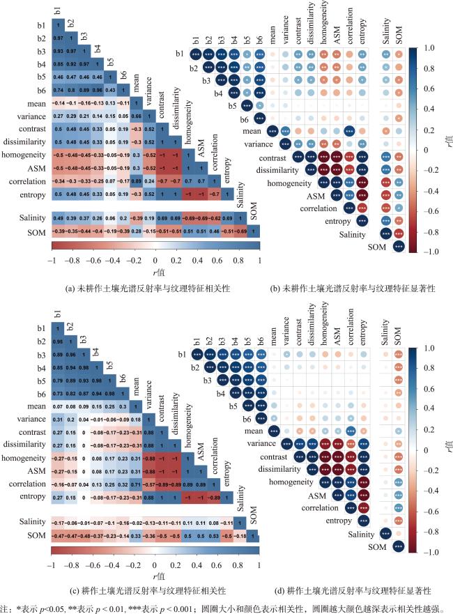
表1 基于未耕作土壤光谱筛选的对土壤有机质与盐分敏感的光谱指数及对应的相关性与显著性值Tab. 1 Selected spectral indices (with their corresponding correlation coefficients and signiciant values) sensitive to soil organic matter and salinity in uncultivated soil |
| 光谱指数 | r | p | |
|---|---|---|---|
| 有机质敏感光谱指数 | D23 | 0.533 | 0.002 |
| D31 | -0.426 | 0.019 | |
| T_b1 | 0.388 | 0.034 | |
| T_b3 | 0.439 | 0.015 | |
| T_b6 | 0.389 | 0.034 | |
| 盐分敏感光谱指数 | NDD21 | -0.468 | 0.009 |
| NDD34 | 0.521 | 0.003 | |
| NDD61 | -0.483 | 0.007 | |
| T_b1 | -0.475 | 0.008 |
表2 基于耕作土壤光谱筛选的对土壤有机质和盐分敏感的光谱指数及对应的相关性和显著性值Tab. 2 Selected spectral indices (with their corresponding correlation coefficients and signiciant values) sensitive to soil organic matter and salinity in cultivated soil |
| 光谱指数 | r | p | |
|---|---|---|---|
| 有机质敏感光谱指数 | D43 | 0.51 | 1.32E-04 |
| D45 | -0.54 | 3.32E-05 | |
| D53 | 0.59 | 3.33E-06 | |
| D64 | 0.57 | 1.11E-05 | |
| R34 | -0.63 | 6.49E-07 | |
| R52 | 0.60 | 3.04E-06 | |
| R53 | 0.72 | 2.08E-09 | |
| R61 | 0.53 | 6.22E-05 | |
| T_b1 | 0.48 | 3.21E-04 | |
| T_b3 | 0.49 | 2.35E-04 | |
| 盐分敏感光谱指数 | R13 | -0.35 | 9.84E-03 |
| NDD12 | -0.37 | 6.73E-03 |
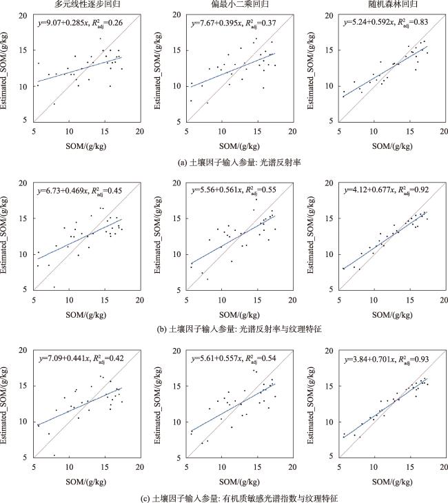
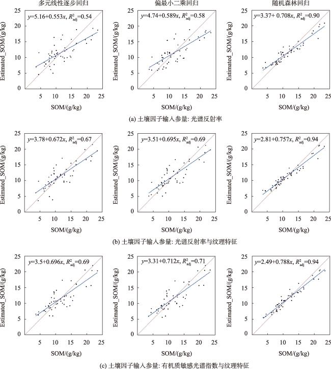
表3 不同输入参量的未耕作土壤有机质反演精度比较Tab. 3 Comparison of estimation accuracy of uncultivated soil organic matter with different input parameters |
| 策略 | 土壤因子输入参量 | 评价指标 | 多元线性逐步回归 | 偏最小二乘回归 | 随机森林回归 |
|---|---|---|---|---|---|
| 1 | 土壤光谱反射率 | R2 | 0.26 | 0.37 | 0.83 |
| RMSE/(g/kg) | 2.93 | 2.71 | 1.69 | ||
| MAPE/% | 22.55 | 20.66 | 13.00 | ||
| 2 | 土壤光谱反射率与纹理特征 | R2 | 0.45 | 0.55 | 0.92 |
| RMSE/(g/kg) | 2.53 | 2.30 | 1.30 | ||
| MAPE/% | 20.53 | 17.90 | 9.74 | ||
| 3 | 土壤有机质敏感光谱指数与纹理特征 | R2 | 0.42 | 0.54 | 0.93 |
| RMSE (g/kg) | 2.59 | 2.31 | 1.22 | ||
| MAPE/% | 20.69 | 17.71 | 9.33 | ||
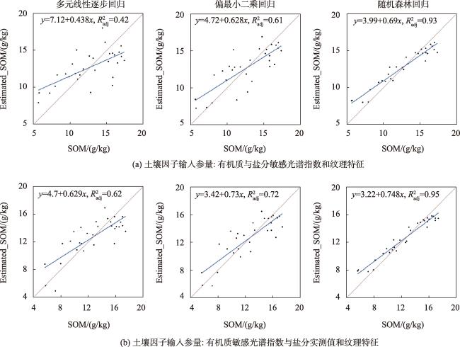
| 4 | 土壤有机质和盐分敏感光谱指数与纹理特征 | R2 | 0.42 | 0.61 | 0.93 |
| RMSE (g/kg) | 2.60 | 2.12 | 1.26 | ||
| MAPE/% | 19.59 | 15.75 | 9.55 | ||
| 5 | 土壤有机质敏感光谱指数和盐分实测值与纹理特征 | R2 | 0.62 | 0.72 | 0.95 |
| RMSE/ (g/kg) | 2.11 | 1.80 | 1.07 | ||
| MAPE/% | 15.40 | 12.45 | 8.08 |
图6 基于光谱与纹理特征的未耕作土壤有机质反演结果Fig. 6 Estimation results of organic matter in uncultivated soil based on spectral and texture characteristics |
表4 不同输入参量的耕作土壤有机质反演精度比较Tab. 4 Comparison of estimation accuracy of cultivated soil organic matter with different input parameters |
| 策略 | 土壤因子输入参量 | 评价指标 | 多元线性逐步回归 | 偏最小二乘回归 | 随机森林回归 |
|---|---|---|---|---|---|
| 1 | 土壤光谱反射率 | R2 | 0.54 | 0.58 | 0.90 |
| RMSE/(g/kg) | 3.11 | 2.98 | 1.74 | ||
| MAPE/% | 25.48 | 24.43 | 14.47 | ||
| 2 | 土壤光谱反射率与纹理特征 | R2 | 0.67 | 0.69 | 0.94 |
| RMSE/(g/kg) | 2.66 | 2.57 | 1.45 | ||
| MAPE/% | 21.01 | 19.55 | 12.29 | ||
| 3 | 土壤有机质敏感光谱指数与纹理特征 | R2 | 0.69 | 0.71 | 0.94 |
| RMSE/ (g/kg) | 2.56 | 2.49 | 1.36 | ||
| MAPE/% | 20.64 | 19.79 | 10.84 | ||
| 4 | 土壤有机质与盐分敏感光谱指数与纹理特征 | R2 | 0.69 | 0.72 | 0.94 |
| RMSE/ (g/kg) | 2.54 | 2.45 | 1.32 | ||
| MAPE/% | 20.20 | 20.10 | 10.38 | ||
| 5 | 土壤有机质敏感光谱指数和盐分实测值与纹理特征 | R2 | 0.69 | 0.71 | 0.94 |
| RMSE/ (g/kg) | 2.56 | 2.48 | 1.30 | ||
| MAPE/% | 20.64 | 19.75 | 10.43 |
图8 基于光谱与纹理特征的耕作土壤有机质反演结果Fig. 8 Estimation results of organic matter in cultivated soil based on spectral and texture characteristics |
| [1] |
马玉蕾, 王德, 刘俊民, 等. 黄河三角洲典型植被与地下水埋深和土壤盐分的关系[J]. 应用生态学报, 2013, 24(9):2423-2430.
[
|
| [2] |
|
| [3] |
|
| [4] |
乔璐. 哈尔滨城区土壤高光谱特性与TM遥感的定量反演[D]. 哈尔滨: 东北林业大学, 2010.
[
|
| [5] |
顾晓鹤, 王堃, 潘瑜春, 等. 基于HJ1AHSI超光谱影像的耕地有机质遥感定量反演[J]. 地理与地理信息科学, 2011, 27(6):69-73.
[
|
| [6] |
刘焕军, 张美薇, 杨昊轩, 等. 多光谱遥感结合随机森林算法反演耕作土壤有机质含量[J]. 农业工程学报, 2020, 36(10):134-140.
[
|
| [7] |
刘焕军, 潘越, 窦欣, 等. 黑土区田块尺度土壤有机质含量遥感反演模型[J]. 农业工程学报, 2018, 34(1):127-133.
[
|
| [8] |
黄静, 赵庚星, 奚雪, 等. 光谱与纹理信息结合的黄河三角洲土壤盐渍化信息提取——以垦利区为例[J]. 农业资源与环境学报, 2022, 39(3):594-601.
[
|
| [9] |
|
| [10] |
|
| [11] |
|
| [12] |
贺军亮, 蒋建军, 周生路, 等. 土壤有机质含量的高光谱特性及其反演[J]. 中国农业科学, 2007, 40(3):638-643.
[
|
| [13] |
郑立华, 李民赞, 潘娈, 等. 基于近红外光谱技术的土壤参数BP神经网络预测[J]. 光谱学与光谱分析, 2008, 28(5):1160-1164.
[
|
| [14] |
陈德宝, 陈桂芬. 基于Landsat8遥感图像的黑土区土壤有机质含量反演研究[J]. 中国农机化学报, 2020, 41(6):194-198.
[
|
| [15] |
马驰. 基于Landsat8吉林中北部地区土壤有机质定量反演研究[J]. 干旱区资源与环境, 2017, 31(2):167-172.
[
|
| [16] |
刘焕军, 赵春江, 王纪华, 等. 黑土典型区土壤有机质遥感反演[J]. 农业工程学报, 2011, 27(8):211-215.
[
|
| [17] |
|
| [18] |
关文昊, 刘志刚, 何国兴, 等. 三江源高寒退化草原土壤有机质含量的光谱模拟估算[J]. 草原与草坪, 2022, 42(5):28-36.
[
|
| [19] |
|
| [20] |
|
| [21] |
张新乐, 窦欣, 谢雅慧, 等. 引入时相信息的耕地土壤有机质遥感反演模型[J]. 农业工程学报, 2018, 34(4):143-150,315.
[
|
| [22] |
武彦清, 张柏, 宋开山, 等. 松嫩平原土壤有机质含量高光谱反演研究[J]. 中国科学院研究生院学报, 2011, 28(2):187-194.
[
|
| [23] |
郑淼, 王翔, 李思佳, 等. 黑土区土壤有机质和全氮含量遥感反演研究[J]. 地理科学, 2022, 42(8):1336-1347.
[
|
| [24] |
|
| [25] |
|
| [26] |
|
| [27] |
|
| [28] |
|
| [29] |
吴国明, 范文义, 司国玉. 全极化合成孔径雷达高维小样本数据在森林地上生物量估算中的应用[J]. 东北林业大学学报, 2022, 50(8):74-82.
[
|
| [30] |
邢晓语, 杨秀春, 徐斌, 等. 基于随机森林算法的草原地上生物量遥感估算方法研究[J]. 地球信息科学学报, 2021, 23(7):1312-1324.
[
|
| [31] |
|
| [32] |
鲍士旦. 土壤农化分析[M]. 3版. 北京: 中国农业出版社, 2000.
[
|
| [33] |
|
| [34] |
张小美, 高春瑞, 闫晓斌, 等. 典型山西黄土高原区土壤有机质的空间异质性及空间插值预测[J]. 山西农业科学, 2023, 51(7):785-792.
[
|
| [35] |
|
| [36] |
张霄羽, 姚艳敏, 颜祥照. 光谱变换和光谱分辨率对土壤有机质含量估测精度的影响[J]. 中国土壤与肥料, 2023(3):184-193.
[
|
| [37] |
|
| [38] |
夏晨真, 姜艳艳, 张星宇, 等. 基于无人机高光谱影像的黑土区玉米农田土壤有机质估算[J]. 光谱学与光谱分析, 2023, 43(8):2617-2626.
[
|
| [39] |
王曦, 李玉环, 王瑞燕, 等. 基于无人机的冬小麦拔节期表层土壤有机质含量遥感反演[J]. 应用生态学报, 2020, 31(7):2399-2406.
[
|
| [40] |
杨玮, 于滈, 李浩, 等. 基于多光谱图像的土壤有机质含量预测系统与APP设计[J/OL]. 农业机械学报, 2023:1-13.(2023-07-12).https://kns.cnki.net/kcms/detail/11.1964.s.20230711.1322.008.html.
[
|
| [41] |
|
| [42] |
|
/
| 〈 |
|
〉 |