
地理信息学科发展的思考
|
闾国年(1961— ),男,江苏南通人,教授,博士生导师,研究方向为地理信息系统理论与应用。E-mail: gnlu@njnu.edu.cn |
收稿日期: 2024-03-19
修回日期: 2024-04-16
网络出版日期: 2024-05-11
基金资助
国家自然科学基金项目(41930648)
国家自然科学基金项目(41842047)
国家自然科学基金项目(41930104)
Reflections on the Development of the Geographic Information Discipline
Received date: 2024-03-19
Revised date: 2024-04-16
Online published: 2024-05-11
Supported by
National Natural and Science Foundation of China(41930648)
National Natural and Science Foundation of China(41842047)
National Natural and Science Foundation of China(41930104)
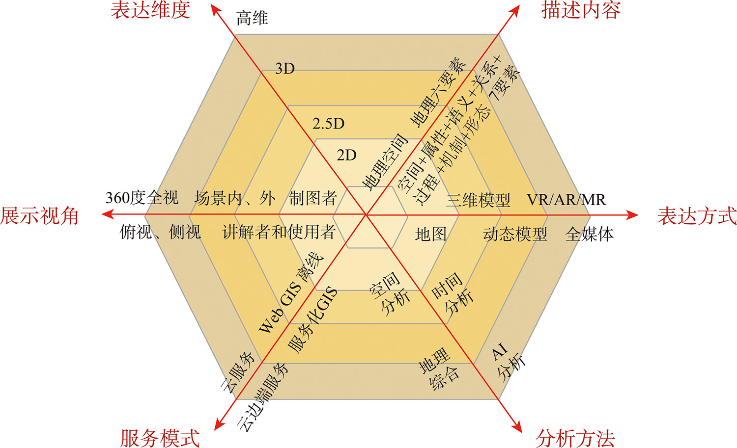
地理信息科学(GIS)既有学科自身发展的需求,也是支撑地理学、地球系统科学和未来地球学等前沿探索的技术方法,还是服务于国家战略与社会发展的支撑技术。面对当今地理信息科学发展的内在规律、相关学科发展的外在驱动,以及人工智能等新技术的牵引,本文首先从描述内容、表达维度、表达方式、分析方法与服务模式6个维度,分析了GIS的发展过程,探索了其发展规律;然后,在解读地理学发展的初心与目标的基础上,提出了面向“物理-人文-信息”三元世界的地理学学科体系,讨论了信息地理学研究对象,提出了一个综合信息7要素与地理描述7维度的概念模型;随后,从信息科学视角的地理信息科学、地理学视角的信息地理学、以及语言学视角的地理语言学3个方面分析了地理信息学科的发展趋势。最后,总结了GIS、信息时代的地理学、地理场景、地理大模型等可能的发展方向和要点,以期丰富对地理信息学科的认识,促进地理信息相关科学的发展,提升学科对国家发展需求支撑和社会服务能力。

闾国年 , 袁林旺 , 陈旻 , 张雪英 , 周良辰 , 俞肇元 , 罗文 , 乐松山 , 吴明光 . 地理信息学科发展的思考[J]. 地球信息科学学报, 2024 , 26(4) : 767 -778 . DOI: 10.12082/dqxxkx.2024.240149
Geographic Information Science (GIS) is not only the demand for the development of the discipline itself, but also the technical method to support the exploration of the frontiers of geography, earth system science and future geography, and the supporting technology to serve the national strategy and social development. In view of the intrinsic law of the development of geographic information science, the extrinsic drive of the development of related disciplines, and the pull of new technologies such as Artificial Intelligence (AI), this paper firstly analyses the development process of GIS and explores its development law from six dimensions, such as description content, expression dimension, expression mode, analysis method and service mode, etc.; then, on the basis of interpreting the original intention and goal of the development of geography, a geography discipline system oriented to the "physical-humanistic-informational" triadic world is proposed, the research object of information geography is discussed, and a conceptual model integrating the seven elements of information and seven dimensions of geographic descriptions is put forward; then, the development trend of geographic information science is analysed from three aspects, including geography from the perspective of information science, information geography from the perspective of geography, and geo-linguistics from the perspective of linguistics, information geography from the perspective of geography, and geolinguistics from the perspective of linguistics, the development trend of geographic information discipline is analysed. Finally, the paper summarises the possible directions and points of development of GIS, geography in the information age, geo-scenario, and geo-big model. We hope that our work can contribute to enriching the understanding of geographic information disciplines, promoting the development of geographic information related sciences, and enhancing the ability of the discipline to support national development needs and serve society.

| [1] |
|
| [2] |
|
| [3] |
陈洪经. 关于建立信息地理学的讨论[J]. 地球科学进展, 1995, 10(1):57-69.
[
|
| [4] |
季增民. 信息地理学初探[J]. 人文地理, 1989, 4(3):17-22.
[
|
| [5] |
闾国年, 袁林旺, 俞肇元. 信息地理学:地理三元世界的新支点[J]. 中国科学:地球科学, 2022, 52(2):374-376.
[
|
| [6] |
周良辰, 盛业华, 林冰仙, 等. 球面菱形离散格网正二十面体剖分法[J]. 测绘学报, 2014, 43(12):1293-1299.
[
|
| [7] |
吴明光. 一种空间分布模式驱动的空间索引[J]. 测绘学报, 2015, 44(1):108-115.
[
|
| [8] |
闾国年, 袁林旺, 俞肇元. 地理学视角下测绘地理信息再透视[J]. 测绘学报, 2017, 46(10):1549-1556.
[
|
| [9] |
肖乐斌, 钟耳顺, 刘纪远, 等. 三维GIS的基本问题探讨[J]. 中国图象图形学报, 2001, 6(9):842-848.
[
|
| [10] |
|
| [11] |
崔珂瑾, 程昌秀. 空间数据模型研究综述[J]. 地理信息世界, 2013, 20(3):31-38.
[
|
| [12] |
The Open Geospatial Consortium. OGC Reference Model[R]. 2011.
|
| [13] |
|
| [14] |
宋珉, 鹏超, 赵维, 等. 2.5维地图制作算法研究与实现[J]. 城市勘测. 2010(5):104-106.
[
|
| [15] |
尹章才, 李霖. 基于快照-增量的时空索引机制研究[J]. 测绘学报, 2005, 34(3):257-261,282.
[
|
| [16] |
龚健雅, 李小龙, 吴华意. 实时GIS时空数据模型[J]. 测绘学报, 2014, 43(3):226-232.
[
|
| [17] |
袁林旺, 闾国年, 罗文, 等. GIS多维统一计算的几何代数方法[J]. 科学通报, 2012, 57(4):282-290.
[
|
| [18] |
|
| [19] |
|
| [20] |
|
| [21] |
唐旭日, 陈小荷, 张雪英. 中文文本的地名解析方法研究[J]. 武汉大学学报(信息科学版), 2010, 35(8):930-935,982.
[
|
| [22] |
张雪英, 朱少楠, 张春菊. 中文文本的地理命名实体标注[J]. 测绘学报, 2012, 41(1):115-120.
[
|
| [23] |
|
| [24] |
|
| [25] |
|
| [26] |
|
| [27] |
|
| [28] |
|
| [29] |
|
| [30] |
|
| [31] |
张恒才, 陆锋, 陈洁. 微博客蕴含交通信息的提取[J]. 中国图象图形学报, 2013, 18(1):123-129.
[
|
| [32] |
李德仁, 朱庆, 李霞飞. 数码城市:概念、技术支撑和典型应用[J]. 武汉测绘科技大学学报, 2000, 25(4):283-288,311.
[
|
| [33] |
朱庆, 李德仁, 龚健雅, 等. 数码城市GIS的设计与实现[J]. 武汉大学学报(信息科学版), 2001, 26(1):8-11,17.
[
|
| [34] |
高俊, 夏运钧, 游雄, 等. 虚拟现实在地形环境仿真中的应用[M]. 北京: 解放军出版社, 1999.
[
|
| [35] |
林珲, 龚建华, 施晶晶. 从地图到地理信息系统与虚拟地理环境——试论地理学语言的演变[J]. 地理与地理信息科学, 2003, 19(4):18-23.
[
|
| [36] |
|
| [37] |
|
| [38] |
|
| [39] |
|
| [40] |
|
| [41] |
|
| [42] |
郭仁忠. 空间分析[M]. 武汉: 武汉测绘科技大学出版社, 1997.
[
|
| [43] |
陈军, 孙玉国. 基于GIS的城市多因素模糊综合评价[J]. 武汉测绘科技大学学报, 1988, 13(4):99-104.
[
|
| [44] |
|
| [45] |
向素玉, 陈军. 基于GIS城市洪水淹没模拟分析[J]. 地球科学:中国地质大学学报, 1995.
[
|
| [46] |
樊杰. “人地关系地域系统” 是综合研究地理格局形成与演变规律的理论基石[J]. 地理学报, 2018, 73(4):597-607.
[
|
| [47] |
黎夏, 叶嘉安. 遗传算法和GIS结合进行空间优化决策[J]. 地理学报, 2004, 59(5):745-753.
[
|
| [48] |
何晋强, 黎夏, 刘小平, 等. 蚁群智能及其在大区域基础设施选址中的应用[J]. 遥感学报, 2009, 13(2):246-256.
[
|
| [49] |
黎夏. 地理模拟系统:元胞自动机与多智能体[M]. 北京: 科学出版社, 2007.
[
|
| [50] |
|
| [51] |
冯娅娅, 潘竟虎, 杨亮洁. 中国县域农村贫困的空间模拟分析[J]. 地球信息科学学报, 2018, 20(3):321-331.
[
|
| [52] |
庄育龙, 田原, 程楚云. 基于深度神经网络的滑坡危险性评价——以深圳市为例[J]. 地理与地理信息科学, 2019, 35(2):104-110.
[
|
| [53] |
高松. 地理空间人工智能的近期研究总结与思考[J]. 武汉大学学报(信息科学版), 2020, 45(12):1865-1874.
[
|
| [54] |
李新, 袁林旺, 裴韬, 等. 信息地理学学科体系与发展战略要点[J]. 地理学报, 2021, 76(9):2094-2103.
[
|
| [55] |
刘瑜, 郭浩, 李海峰, 等. 从地理规律到地理空间人工智能[J]. 测绘学报, 2022, 51(6):1062-1069.
[
|
| [56] |
宋关福, 钟耳顺, 王尔琪. WebGIS—基于Internet的地理信息系统[J]. 中国图象图形学报, 1998, 3(3):251-254.
[
|
| [57] |
|
| [58] |
NRC. The rise of games and high-performance computing for modeling and simulation[M]. Washington, D.C.: National Academies Press, 2010.
|
| [59] |
|
| [60] |
刘鹏. 云计算(2版).[M]. 北京: 电子工业出版社, 2011.
[
|
| [61] |
张文柱, 余静华. 移动边缘计算中基于云边端协同的任务卸载策略[J]. 计算机研究与发展, 2023, 60(2):371-385.
[
|
| [62] |
闾国年, 俞肇元, 袁林旺, 等. 地图学的未来是场景学吗?[J]. 地球信息科学学报, 2018, 20(1):1-6.
[
|
| [63] |
吴明光, 孙彦杰, 闾国年. 地图风格迁移:概念、综述与展望[J]. 武汉大学学报(信息科学版), 2022, 47(12):2069-2084.
[
|
| [64] |
游雄, 李科, 田江鹏, 等. 机器地图信息加工模型[J]. 武汉大学学报(信息科学版), 2024, 49(4):516-526.
[
|
| [65] |
李德仁. 论自动化和智能化空间对地观测数据处理系统的建立[J]. 环境遥感, 1994(1):1-10.
[
|
| [66] |
郑绛宇. 用路途全景图增强地理信息系统的可视性[J]. 遥感学报, 2006, 10(3):397-408.
[
|
| [67] |
俞肇元, 袁林旺, 吴明光, 等. 地理学视角下地理信息的分类与描述[J]. 地球信息科学学报, 2022, 24(1):17-24.
[
|
| [68] |
胡最, 汤国安, 闾国年. GIS作为新一代地理学语言的特征[J]. 地理学报, 2012, 67(7):867-877.
[
|
/
| 〈 |
|
〉 |