
地形场景的地理空间认知与内容表达
|
朱红春(1977— ),男,山东泰安人,博士,教授,主要从事GIS应用、遥感图像处理与分析的研究。 E-mail: sdny_xa@163.com |
收稿日期: 2023-08-04
修回日期: 2023-09-13
网络出版日期: 2024-05-11
基金资助
国家自然科学基金项目(41971339)
山东科技大学科研创新团队支持计划项目(2019TDJH103)
Research on Geospatial Cognition and Content Expression of Terrain Scenes
Received date: 2023-08-04
Revised date: 2023-09-13
Online published: 2024-05-11
Supported by
National Natural Science Foundation of China(41971339)
Shandong University of Science and Technology Research Innovation Team Support Program(2019TDJH103)
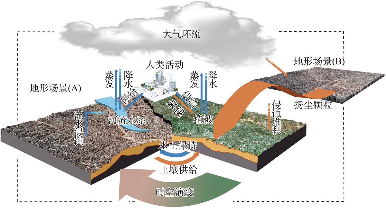
地球表面空间承载着诸多地理实体,随着时空大数据时代的到来,以还原论为基础、以独立分层建模为特征的传统信息描述方式越发难以描述地形及其关联环境要素所具有的海量信息、产生的复杂相互作用和呈现的时空变化规律,相关研究亟需以系统和整体的角度考察研究对象。针对这一问题,本文从场景学的视角对地形本体及关联环境要素的内容和相互作用开展系统的地理空间认知,提出了地形场景的概念,用于整体性地描述地形场景中的实体、联系与时空变化过程;分析了地形场景的要素构成和逻辑结构,使用时间、地点(空间)、事物、事件、现象为核心的更加整体化、语义化和逻辑化的要素对地形场景进行描述;对地形场景对象及其信息的内容构成进行解析和整理,创建了以“要素-对象-信息”为核心的结构描述框架,并对地形场景未来的发展与可能的技术应用进行了展望。地形场景的提出是场景学概念从整体表达朝向整体研究的一次探索,为进一步进行地形问题的场景化求解和表达奠定基础。
朱红春 , 张怡宁 , 徐月雪 , 朱国灿 , 宋词 . 地形场景的地理空间认知与内容表达[J]. 地球信息科学学报, 2024 , 26(4) : 790 -798 . DOI: 10.12082/dqxxkx.2024.230450
The Earth's surface exhibits a diverse topography, characterized by ups and downs in spatial geometry and carrying many geographical entities. With the advent of the era of spatiotemporal big data, the exploration of geospatial information gradually has shifted from spatial perception to spatial cognition. However, traditional information description methods based on Reductionism and independent hierarchical modeling are increasingly oriented toward geographic information management and visualization. It is difficult to describe the massive information, complex interactions, and spatiotemporal changes of terrain and its associated environmental elements using this information description method. To address this issue, this paper conducts a systematic geospatial analysis of the content and interaction of terrain ontology and associated environmental elements from the perspective of scenario science. We comprehensively describe the entities, relations, and spatiotemporal changes in the terrain scenario. Here, the terrain scenario is defined as the specific environment in which the terrain exists and the state changes. It is a regional complex composed of terrain objects and other natural and human objects with connections and functions within a certain time and space. The element composition and logical structure of terrain scenario are analyzed by employing holistic, semantic, and logical elements centered around time, place (space), things, events, and phenomena to describe terrain scenarios. The elements of terrain scene should be based on the elements of things, develop and evolve in a certain time and space, form the elements of events and phenomena, and finally form a complex that operates dynamically under the framework of time and space. We further analyze and organize the content composition of terrain scene objects and their associated information and create a structure description framework based on element object information architecture. Moreover, we prospect the future development of terrain scenario and the possible technical application directions in the future, such as the geoscience semantic network and knowledge map dominated by terrain and associated elements, the scene event spectrum based on the characteristics of spatiotemporal nodes and associated elements, and the scene holographic digital terrain analysis. The introduction of terrain scenes not only deepens the traditional methods but also provides a new idea at the conceptual level. It is an exploration of the concept of scene science and lays a foundation for a systematic approach for solving and expressing the evolution and development of terrain ontology and environment within the space-time framework.
| [1] |
沈泽昊, 张新时, 金义兴. 地形对亚热带山地景观尺度植被格局影响的梯度分析[J]. 植物生态学报, 2000, 24(4):430-435.
[
|
| [2] |
杨景春, 李有利. 地貌学原理[M]. 4版. 北京: 北京大学出版社, 2017.
[
|
| [3] |
|
| [4] |
张克权, 祝国瑞. 试论地图制图学的理论体系[J]. 武汉测绘科技大学学报, 1990, 15(2):28-33.
[
|
| [5] |
常绍舜. 从经典系统论到现代系统论[J]. 系统科学学报, 2011, 19(3):1-4.
[
|
| [6] |
|
| [7] |
俞肇元, 袁林旺, 吴明光, 等. 地理学视角下地理信息的分类与描述[J]. 地球信息科学学报, 2022, 24(1):17-24.
[
|
| [8] |
李德仁. 展望大数据时代的地球空间信息学[J]. 测绘学报, 2016, 45(4):379-384.
[
|
| [9] |
|
| [10] |
闾国年, 袁林旺, 俞肇元. GIS技术发展与社会化的困境与挑战[J]. 地球信息科学学报, 2013, 15(4):483-490.
[
|
| [11] |
闾国年, 俞肇元, 袁林旺, 等. 地图学的未来是场景学吗?[J]. 地球信息科学学报, 2018, 20(1):1-6.
[
|
| [12] |
郑束蕾. 地理空间认知理论与地图工具的发展[J]. 测绘学报, 2021, 50(6):766-776.
[
|
| [13] |
|
| [14] |
舒红. 关于地理空间认知[A]. 中国科学技术协会. 节能环保和谐发展——2007中国科协年会论文集(二)[C]. 中国科学技术协会:中国科学技术协会学会学术部, 2007:6.
[
|
| [15] |
张超. 地理信息系统应用教程[M]. 北京: 科学出版社, 2007.
[
|
| [16] |
王晓明, 刘瑜, 张晶. 地理空间认知综述[J]. 地理与地理信息科学, 2005, 21(6):1-10.
[
|
| [17] |
杨静飞, 张强. 基于地理信息可视化的空间认知研究[J]. 测绘与空间地理信息, 2013, 36(7):12-14.
[
|
| [18] |
顾日国. 多模态感官系统与语言研究[J]. 当代语言学, 2015, 17(4):448-469.
[
|
| [19] |
|
| [20] |
刘唯佳, 韩永翔, 赵天良. 黄土高原黄土的成因:沙尘气溶胶源汇模拟与黄土堆积[J]. 中国环境科学, 2014, 34(12):3041-3046.
[
|
| [21] |
李裕元, 邵明安. 黄土高原气候变迁、植被演替与土壤干层的形成[J]. 干旱区资源与环境, 2001, 15(1):72-77.
[
|
| [22] |
|
| [23] |
闾国年, 周成虎, 林珲, 等. 地理综合研究方法的发展与思考[J]. 科学通报, 2021, 66(20):2542-2554.
[
|
| [24] |
|
| [25] |
闾国年, 袁林旺, 俞肇元. 地理学视角下测绘地理信息再透视[J]. 测绘学报, 2017, 46(10):1549-1556.
[
|
| [26] |
|
| [27] |
张洪岩, 周成虎, 闾国年, 等. 试论地学信息图谱思想的内涵与传承[J]. 地球信息科学学报, 2020, 22(4):653-661.
[
|
| [28] |
程维明, 宋珂钰, 周成虎, 等. 地貌信息图谱研究述评与展望[J]. 地球科学进展, 2022, 37(7):661-679.
[
|
| [29] |
张春菊, 刘文聪, 张雪英, 等. 基于本体的金矿知识图谱构建方法[J]. 地球信息科学学报, 2023, 25(7):1269-1281.
[
|
| [30] |
|
| [31] |
罗斌, 任丽秋, 毛悦, 等. 全息地球数据立方体模型研究[J]. 地球信息科学学报, 2023, 25(7):1282-1296.
[
|
/
| 〈 |
|
〉 |


