
城市内涝场景下的微地图制作方法
|
富 璇(2000—),女,甘肃白银人,硕士生,主要从事微地图研究。E-mail: 11210873@stu.lzjtu.edu.cn |
收稿日期: 2023-03-27
修回日期: 2023-08-07
网络出版日期: 2024-05-21
基金资助
甘肃省高等学校产业支撑计划项目(2022CYZC-30)
自然资源部城市国土资源监测与仿真重点实验室开放基金资助课题(KF-2022-07-015)
A We-Map Mapping Method for Urban Waterlogging Scenarios
Received date: 2023-03-27
Revised date: 2023-08-07
Online published: 2024-05-21
Supported by
Industrial Support and Program Project of Universities in Gansu Province(2022CYZC-30)
Open Fund of Key Laboratory of Urban Nand Resources Monitoring and Simulation,Ministry of Natural Resources(KF-2022-07-015)
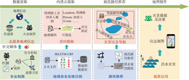
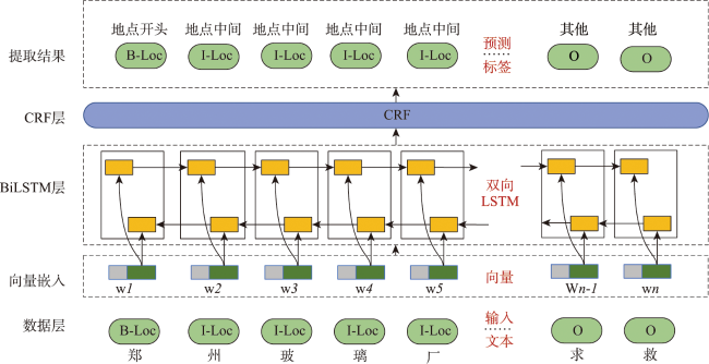
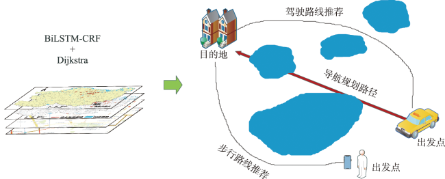
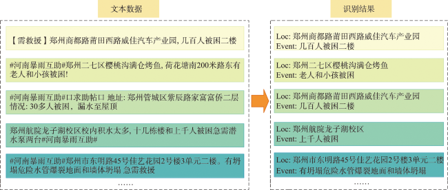
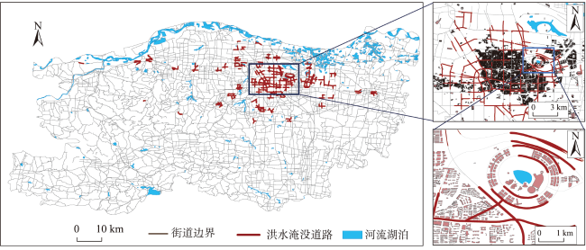
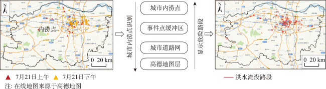
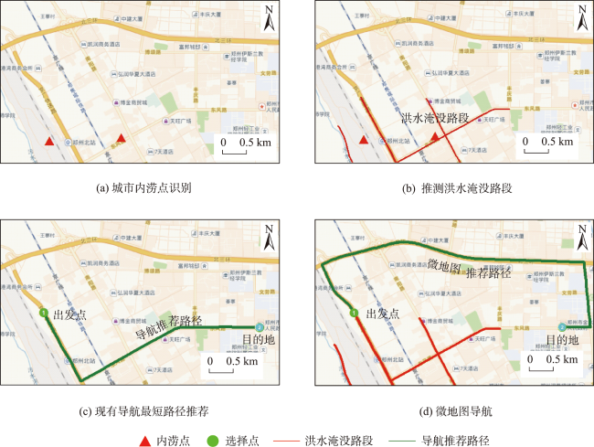
随着我国城市化进程的加快,城市内涝灾害愈加频繁,人民的生命和财产安全受到了严重的威胁。然而,城市内涝灾害在愈加频繁的同时,产生了诸如信息获取不及时、制图时效性低、地图信息冗余等问题,难以为救援提供及时响应。基于此,本文提出了一种面向城市内涝场景下的微地图制作方法。首先,调用微博API获取任意时间段内特定主题下的社交媒体文本数据,对数据进行清洗与预处理;接着,选取BiLSTM-CRF模型提取社交媒体中有关城市内涝的地名地址信息;然后,结合Dijkstra算法为用户推荐避开危险路段的最优路径;最后,结合灾害信息与实际场景,制作城市内涝场景下的微地图。实验结果表明: ①该方法能够有效识别城市内涝点,总体准确率达到92.7%; ②对比官方发布的积水点,本文提取的积水点与官方积水点大部分重叠,能够有效为传统监测方法提供补充信息; ③根据所得内涝点生成道路网级别的城市内涝地图,能够克服在海量地理空间信息中可视化冗余的不足,即有效缓解地理信息冗余的问题。由此可知,实时显示城市内涝信息,能够为用户掌握灾害现场的信息提供便利,调动他们参与制作微地图的积极性。与此同时,结合最优路径推荐,能够提高灾害应急场景下的制图时效。

关键词: 城市内涝; 微地图; 社交媒体; 自然语言处理; Dijkstra算法; BiLSTM-CRF; 最优路径
富璇 , 闫浩文 , 王小龙 , 闫晓婧 , 王卓 , 马文骏 . 城市内涝场景下的微地图制作方法[J]. 地球信息科学学报, 2024 , 26(5) : 1166 -1179 . DOI: 10.12082/dqxxkx.2024.230153
The escalating urbanization in China has exacerbated waterlogging disasters, posing substantial threats to both human lives and property. In response to the challenges of inadequate mapping and redundant map data in urban waterlogging contexts, this study introduces a comprehensive four-stage methodology for We-Map cartography. This cartography encompasses data acquisition, extraction of waterlogging points, route optimization, and scene application. The initial step involves the retrieval of social media text data through queries to the Weibo Application Programming Interface (API) within a defined timeframe. The retrieved data are subsequently subjected to thorough cleaning and preprocessing procedures. Following this, the BiLSTM-CRF model is harnessed to discern urban waterlogging locations from the social media content, thereby enhancing recognition accuracy through contextual insights. Then, users are provided with optimal route for bypassing perilous road segments, achieved via the shortest path algorithm. Leveraging the online map as the foundational framework, the We-Map is generated within the urban waterlogging setting by overlaying multiple layers. Notably, the proposed method attains an impressive overall accuracy rate of 92.7% in pinpointing urban waterlogging locations, thereby substantially enhancing mapping efficiency. A comparative analysis between map-derived waterlogging points and official records reveals a substantial overlap, thus offering valuable supplemental information to conventional monitoring techniques. Furthermore, a road network-level map of urban waterlogging points is also generated to avoid redundancies in vast geospatial information. The identified flood-prone road sections can serve as a reference, while real-time display of urban waterlogging points, coupled with the shortest path algorithm, aids in recommending optimal routes. By leveraging the inherent attributes of "we-content" within the We-Map, this method expedites rapid mapping and fulfills the exigencies of swift mapping during emergencies. To cater to diverse user needs, urban flooding scenarios map are categorized with different tags aligned with their intended applications, encompassing home-bound routes, rescue maps, driving maps, walking maps, storm assistance maps, nearest rescue supplies maps, and more. Each map is endowed with at least one tag, streamlining accurate searches and usage by other users, and concurrently providing a reference for urban rescue operations. The proposed method ensures the coherence of map content and user requisites, facilitating efficient map sharing among users. The real-time dissemination of urban waterlogging information empowers users to swiftly comprehend disaster scenes, engendering their active involvement in We-Map production, and combining optimal path recommendation to augment cartographic responsiveness in emergency disaster scenarios. This approach bears substantial practical significance and promising application potential, constituting a robust for urban waterlogging emergency responses.
表2 实验环境配置Tab. 2 Experimental environment configuration |
| 名称 | 配置信息 |
|---|---|
| 操作系统 | Windows 10 |
| 开发语言 | Python 3.6 |
| 框架 | PyTorch 1.10.2 |
| GPU | NVIDIA RTX 3060 (12 G) |
| 内存 | 32 G |
表3 实验测试结果Tab. 3 Experimental test results |
| 预测出正确的实体名称数/个 | 预测出的所有实体名称数/个 | 所有标注的实体数/个 | 准确率/% | |
|---|---|---|---|---|
| P | 45 719 | 49 304 | 92.7 | |
| R | 45 719 | 50 024 | 91.4 | |
| F1 | 92.1 |
表4 传统制图方法与微地图制图方法对比Tab. 4 Comparison between conventional mapping and we-map mapping methods |
| 传统制图方法 | 微地图制图方法 | |
|---|---|---|
| 数据来源 | 遥感影像、水位监测站 | 社交媒体文本数据 |
| 覆盖范围 | 有限 | 广泛 |
| 表达地理信息内容 | 专业、冗余 | 简单、有针对性 |
| 制图周期 | 长 | 短 |
| 制图对象 | 专业制图人员 | 专业制图人员、非专业制图人员 |
| 传播方式 | 点到点,点对多 | 多对多 |
| 获取信息时效性 | 低 | 高 |
| 地图制作现势性 | 低 | 高 |
| 制图成本 | 高 | 低 |
| [1] |
张冬冬, 严登华, 王义成, 等. 城市内涝灾害风险评估及综合应对研究进展[J]. 灾害学, 2014, 29(1):144-149.
[
|
| [2] |
周延, 佘敦先, 夏军, 等. 基于水文水动力模型的LID措施对城市内涝风险的影响研究[J]. 武汉大学学报(工学版), 2022, 55(11):1090-1101.
[
|
| [3] |
|
| [4] |
吴建华, 胡烈云, 赵宇, 等. 基于BiLSTM-CRF与分类分层标注的微博中突发事件时空信息精细识别方法[J]. 地理与地理信息科学, 2021, 37(3):1-8.
[
|
| [5] |
闫浩文, 张黎明, 杜萍, 等. 自媒体时代的地图:微地图[J]. 测绘科学技术学报, 2016, 33(5):520-523.
[
|
| [6] |
白娅兰, 闫浩文, 禄小敏, 等. 微地图符号的视觉变量及其应用[J]. 测绘科学, 2021, 46(7):182-188,204.
[
|
| [7] |
闫晓婧, 闫浩文, 王小龙, 等. 微地图符号的智能化匹配——“识图配符”[J]. 测绘科学, 2022, 47(10):205-212.
[
|
| [8] |
何阳, 闫浩文, 王卓, 等. 面向微地图的地标提取方法及个性化寻路应用[J]. 地球信息科学学报, 2022, 24(5):827-836.
[
|
| [9] |
|
| [10] |
朱晓寒, 李向阳, 刘昭阁. 大数据环境下城市内涝灾害的情景维度模型构建[J]. 武汉大学学报·信息科学版, 2020, 45(11):1818-1828.
[
|
| [11] |
邬柯杰, 吴吉东, 叶梦琪. 社交媒体数据在自然灾害应急管理中的应用研究综述[J]. 地理科学进展, 2020, 39(8):1412-1422.
[
|
| [12] |
曹建成, 王凯, 郭朝阳. 天地图客户端自助制图技术研究[J]. 测绘通报, 2016(9):123-126,132.
[
|
| [13] |
李素菊. 多方联动实景制图机制介绍[J]. 中国减灾, 2018(23):58-59.
[
|
| [14] |
任福, 严涵, 龚丽芳, 等. 多空间尺度的灾害应急动态制图规则[J]. 测绘地理信息, 2020, 45(3):1-7.
[
|
| [15] |
伍智超, 王超, 李秉清, 等. 基于社交媒体数据的武汉内涝时空统计分析[J]. 测绘地理信息, 2022, 47(5):89-92.
[
|
| [16] |
王艳东, 李昊, 王腾, 等. 基于社交媒体的突发事件应急信息挖掘与分析[J]. 武汉大学学报·信息科学版, 2016, 41(3):290-297.
[
|
| [17] |
佟金萍, 张涵玥, 刘辉, 等. 基于XGBoost的长三角核心城市内涝风险评估及影响因素分析[J]. 水利水电技术(中英文), 2021, 52(10):1-11.
[
|
| [18] |
周锐. 基于社交媒体的城市内涝灾害信息实时挖掘与分析[D]. 武汉: 华中科技大学, 2021.
[
|
| [19] |
|
| [20] |
|
| [21] |
王荩梓. 社交媒体中城市内涝信息提取与分析[D]. 上海: 华东师范大学, 2020.
[
|
| [22] |
|
| [23] |
叶鹏, 张雪英, 张春菊. 基于微博文本的灾害事件信息时空过程聚合方法[J]. 测绘学报, 2023, 52(3):490-500.
[
|
| [24] |
王国昱. 基于深度学习的中文命名实体识别研究[D]. 北京: 北京工业大学, 2015.
[
|
| [25] |
程博, 李卫红, 童昊昕. 基于BiLSTM-CRF的中文层级地址分词[J]. 地球信息科学学报, 2019, 21(8):1143-1151.
[
|
| [26] |
|
| [27] |
|
| [28] |
|
/
| 〈 |
|
〉 |