
基于多源开放数据的城市多中心定量识别方法
|
姜永青(1997—),男,山东威海人,硕士生,主要研究方向为时空数据挖掘与城市空间规划。E-mail: arbeitskonto_jiang@163.com |
收稿日期: 2023-07-01
修回日期: 2023-09-29
网络出版日期: 2024-05-21
基金资助
国家自然科学基金项目(42371226)
Quantitative Identification Method of Urban Multi-center Based on Multi-source Open Data
Received date: 2023-07-01
Revised date: 2023-09-29
Online published: 2024-05-21
Supported by
National Natural Science Foundation of China(42371226)
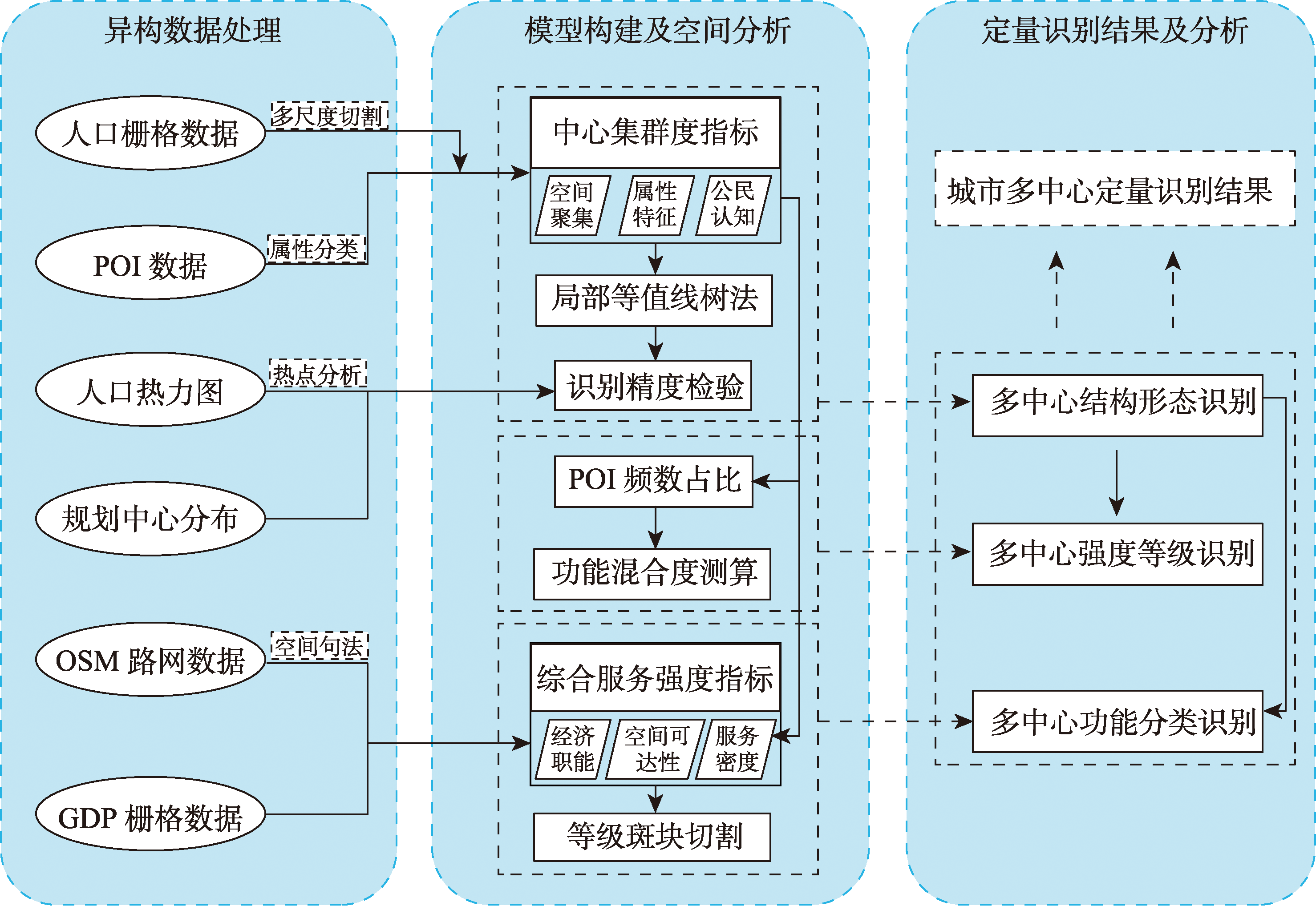
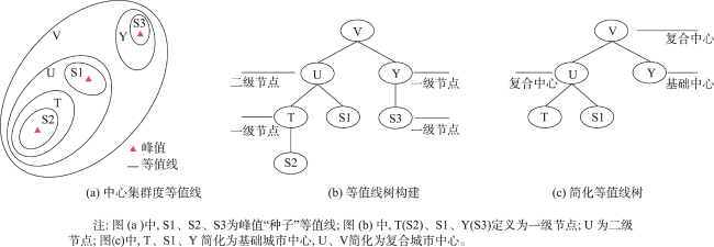
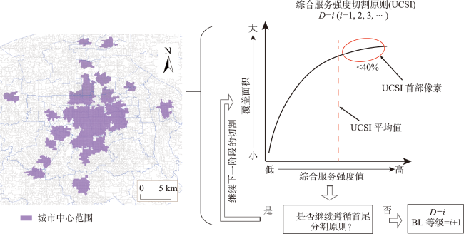
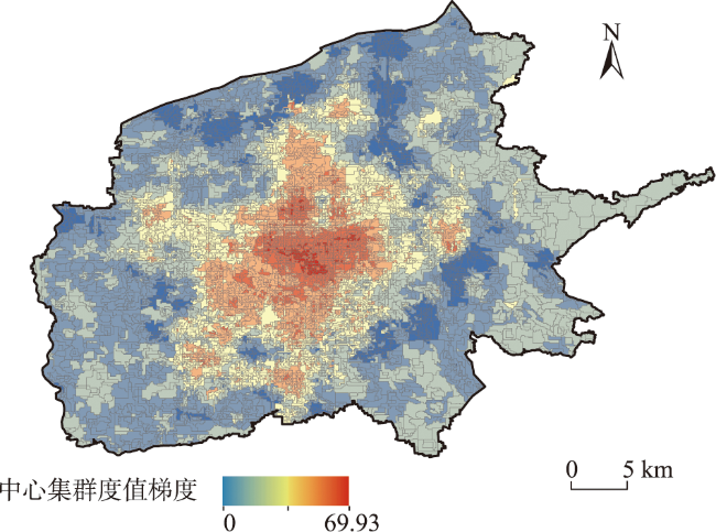
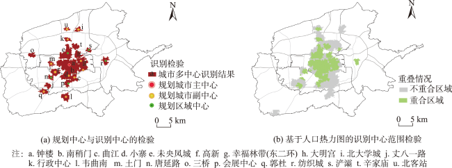
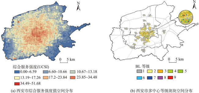
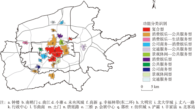
开展城市多中心研究对于优化城市空间结构、合理配置空间要素及加强城市规划管理具有重要意义。现有研究围绕多中心识别进行了大量实证分析,但尚未建立一套统一的评定标准。为此,本文以POI、人口分布、OSM路网等多源开放数据为基础,构建了一套从结构形态到强度等级和功能分类的城市多中心定量识别方法。① 结构形态方面,基于对POI数据的多属性加权分析构建多中心结构特征指标—“中心集群度”,并通过参数优化后的局部等值线树算法识别城市多中心的范围与边界。② 强度等级方面,通过构建多中心综合服务强度指标(UCSI),运用首尾切割规则对多中心内部进行了强度斑块划分并计算多中心强度等级(UCL)。③ 功能分类方面,通过计算融入加权属性后的POI数据的频数占比,识别多中心的功能组合关系与分类。最后以西安市为例进行模拟实证,发现:西安市传统单核心的城市结构表现出明显的扩散趋势,共识别出21个城市中心的位置和边界,分别为3个城市主中心、5个城市副中心以及13个区域中心;各城市中心强度等级呈“核心-外围”圈层式递减特征;识别出4个复合型功能中心、12个双功能中心以及5个单一型功能中心。研究结果表明,本文建立的定量识别方法能够精准、系统地识别城市多中心发展特征。针对大城市多中心发展中的突出问题本文提出了相应的政策建议,以期为城市规划的编制与实施提供借鉴意义。
姜永青 , 赵新正 , 李培庆 , 相里博晨 , 张得康 . 基于多源开放数据的城市多中心定量识别方法[J]. 地球信息科学学报, 2024 , 26(5) : 1212 -1228 . DOI: 10.12082/dqxxkx.2024.230362
Conducting research on urban multi-center is of significant importance for optimizing urban spatial structure, rational allocation of spatial elements, and strengthening urban planning and management. Existing studies have conducted numerous empirical research on urban multi-center identification, but a unified set of evaluation criteria has yet to be established. Therefore, based on multi-source open data such as Points of Interest (POI), population distribution, and road networks, this paper constructs a set of quantitative identification methods for urban multi-center in terms of structural morphology, intensity level, and functional classification. For the structural morphology, based on the multi-attribute weighted analysis of POI data, we constructed a multi-center structural characteristic index "center clustering degree" and identified the scope and boundary of urban multi-center through the parameter-optimized local contour tree algorithm. For the intensity level, by constructing the Urban Multi-center Comprehensive Service Intensity Indicator (UCSI), and according to "Head-Tail Breaks" rule, we divided the intensity patches within the multi-center and calculated the Urban Multi-center Intensity Level (UCL). For functional classification, the functional combination relationship and classification of multi-center was identified by calculating the frequency share of POI data after incorporating weighted attributes. Finally, an empirical simulation was conducted using the city of Xi'an as a case study. Results show that Xi'an city's traditional single-core urban structure exhibited a distinct diffusion trend, having a total of 21 urban centers (three main urban centers, five secondary urban centers, and 13 regional centers) with their locations and boundaries specified. The intensity level of each urban center was characterized by a decreasing "core-periphery" circle. And four urban composite functional centers, 12 urban dual-functional centers, and five urban single-functional centers were identified. The research results show that the quantitative identification method established in this paper can accurately and systematically identify the characteristics of urban multi-center development. This paper also puts forward corresponding policy suggestions for the prominent problems in the process of multi-center development of large cities and provides reference for the preparation and implementation of urban planning.
表2 POI数据分类及权重属性Tab. 2 POI data weighting attributes |
| 一级分类 | 二级分类 | 具体备注 | 参考面积/hm2 | 公民认知度 |
|---|---|---|---|---|
| 消费娱乐类 | 购物服务 | 综合商业中心级、超市级、便利店级 | 5/1/0.02 | 81.46 |
| 餐饮服务 | 高级餐厅、普通餐厅 | 0.02/0.01 | 65.71 | |
| 休闲娱乐 | 0.03 | 50.01 | ||
| 公共服务类 | 公共设施 | 2 | 40.56 | |
| 体育运动 | 体育馆、其他体育设施 | 5/0.1 | 52.1 | |
| 医疗保健 | 综合医院、专科医院、诊所、其他医疗服务 | 5/2/0.1/0.03 | 50.6 | |
| 政府机关及社会团体 | 0.5 | 35.5 | ||
| 高等教育 | 10 | 67.06 | ||
| 中小学 | 2 | |||
| 科研单位 | 0.3 | |||
| 其他文化设施 | 0.01 | |||
| 生活服务类 | 生活服务 | 0.02 | 71.36 | |
| 汽车废服务 | 4S店、汽车服务维修 | 0.5/0.3 | 55.62 | |
| 住宿服务 | 0.08 | 44.98 | ||
| 其他商业服务 | 0.01 | 28.49 | ||
| 公司商务类 | 金融保险 | 金融保险公司、金融保险商铺 | 0.5/0.02 | 48.69 |
| 法人企业 | 0.03 | 34.57 | ||
| 产业园区 | 4 | 31.45 | ||
| 工业工厂 | 2 | |||
| 景观休闲类 | 旅游景区 | 2 | 72.45 | |
| 公园与广场 | 城市级公园广场、区域级公园广场 | 5/2 | 65.48 | |
| 交通服务类 | 停车场 | 5 | 88.62 | |
| 交通服务设施 | 交通枢纽、其他交通附属设施 | 5/0.02 |
表1 多中心综合服务强度评价指标Tab. 1 Multi-center comprehensive intensity level evaluation index |
| 一级指标 | 二级指标 | 指标详情 | 权重 |
|---|---|---|---|
| 中心服务密度 | POI中心集群度 | 消费娱乐类集群度值 | 0.067 7 |
| 公共服务类集群度值 | 0.043 6 | ||
| 生活服务类集群度值 | 0.051 6 | ||
| 公司商务类集群度值 | 0.039 4 | ||
| 景观休闲类集群度值 | 0.071 1 | ||
| 交通服务类集群度值 | 0.060 4 | ||
| 经济职能强度 | GDP空间分布 | 渔网内GDP栅格数据 | 0.192 8 |
| 人口空间分布 | 渔网内人口栅格数据 | 0.140 2 | |
| 空间可达性 | 空间整合度 | 整合度,亦称集成度,其反映了空间系统区域中各元素间的紧密程度,衡量了该要素在整个系统中的中心程度[45] | 0.333 3 |
| 空间句法可达性 | 指将其围合的道路可达性。在空间单元划分的基础上,综合与邻近路网距离、以及路网自身的属性要素,计算出某单元网格的空间句法交通可达性[27] |
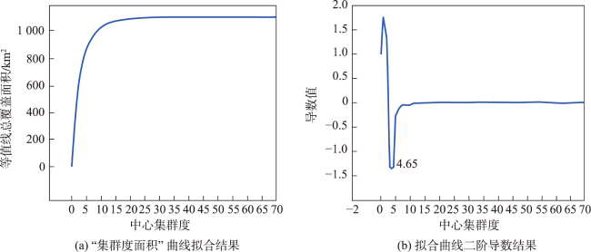
图6 西安市“集群度面积”拟合曲线及二阶导数结果Fig. 6 Central clustering area fitting curve and second derivative result in Xi'an |
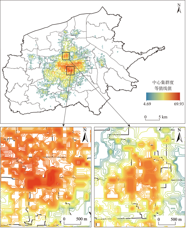
图7 西安市中心集群度等值线树中嵌套关系Fig. 7 Nested relation graph in central clustering contour tree in Xi'an |
表3 西安市各城市中心等级分类和UCI值Tab. 3 Urban centers classification and UCI values in Xi'an |
| ID | 城市中心等级 | UCL | ID | 城市中心等级 | UCL |
|---|---|---|---|---|---|
| a | 城市主中心 | 2.553 | l | 区域中心 | 1.065 |
| b | 2.425 | m | 1.092 | ||
| c | 2.233 | n | 1.452 | ||
| d | 城市副中心 | 1.626 | o | 1.097 | |
| e | 1.611 | p | 1.348 | ||
| f | 1.562 | q | 1.091 | ||
| g | 1.807 | r | 1.135 | ||
| h | 1.605 | s | 1.123 | ||
| i | 区域中心 | 1.081 | t | 1.300 | |
| j | 1.246 | u | 1.092 | ||
| k | 1.181 |
| [1] |
|
| [2] |
吴一洲, 吴次芳, 李波, 等. 城市规划控制绩效的时空演化及其机理探析——以北京1958—2004年间五次总体规划为例[J]. 城市规划, 2013, 37(7):33-41.
[
|
| [3] |
|
| [4] |
伊利尔. 沙里宁. 城市:它的发展、衰败与未来[M]. 北京: 中国建筑工业出版社, 1986.
[
|
| [5] |
|
| [6] |
杨振山, 蔡建明. 国外多中心规划理念与发展经验对中国的借鉴作用[J]. 国际城市规划, 2008, 23(4):71-77.
[
|
| [7] |
罗震东, 朱查松. 解读多中心:形态、功能与治理[J]. 国际城市规划, 2008, 23(1):85-88.
[
|
| [8] |
孙铁山, 王兰兰, 李国平. 北京都市区人口—就业分布与空间结构演化[J]. 地理学报, 2012, 67(6):829-840.
[
|
| [9] |
吴一洲, 赖世刚, 吴次芳. 多中心城市的概念内涵与空间特征解析[J]. 城市规划, 2016, 40(6):23-31.
[
|
| [10] |
孙斌栋, 魏旭红. 多中心结构:我国特大城市的未来形态[J]. 人民论坛·学术前沿, 2015(17):6-15.
[
|
| [11] |
杨俊宴, 章飙, 史宜. 城市中心体系发展的理论框架探索[J]. 城市规划学刊, 2012(1):33-39.
[
|
| [12] |
赵渺希. 多中心城市就业—居住的非完全结构匹配模型[J]. 地理研究, 2017, 36(8):1531-1542.
[
|
| [13] |
|
| [14] |
孙斌栋, 石巍, 宁越敏. 上海市多中心城市结构的实证检验与战略思考[J]. 城市规划学刊, 2010(1):58-63.
[
|
| [15] |
|
| [16] |
周素红, 郝新华, 柳林. 多中心化下的城市商业中心空间吸引衰减率验证——深圳市浮动车GPS时空数据挖掘[J]. 地理学报, 2014, 69(12):1810-1820.
[
|
| [17] |
丁亮, 钮心毅, 宋小冬. 上海中心城就业中心体系测度——基于手机信令数据的研究[J]. 地理学报, 2016, 71(3):484-499.
[
|
| [18] |
王波, 甄峰, 张浩. 基于签到数据的城市活动时空间动态变化及区划研究[J]. 地理科学, 2015, 35(2):151-160.
[
|
| [19] |
龙瀛, 张宇, 崔承印. 利用公交刷卡数据分析北京职住关系和通勤出行[J]. 地理学报, 2012, 67(10):1339-1352.
[
|
| [20] |
|
| [21] |
段亚明, 刘勇, 刘秀华, 等. 基于POI大数据的重庆主城区多中心识别[J]. 自然资源学报, 2018, 33(5):788-800.
[
|
| [22] |
方煜, 石爱华, 孙文勇, 等. 粤港澳大湾区多维空间特征与融合发展策略[J]. 城市规划学刊, 2022(4):78-86.
[
|
| [23] |
张宸铭, 李灵军, 高尚, 等. 交通土地一体化的开封市多中心结构分形研究[J]. 城市规划, 2022, 46(3):63-73.
[
|
| [24] |
王旭辉, 孙斌栋. 特大城市多中心空间结构的经济绩效——基于城市经济模型的理论探讨[J]. 城市规划学刊, 2011(6):20-27.
[
|
| [25] |
李顺成,
[
|
| [26] |
孙斌栋, 涂婷, 石巍, 等. 特大城市多中心空间结构的交通绩效检验——上海案例研究[J]. 城市规划学刊, 2013(2):63-69.
[
|
| [27] |
李欣. 基于引力势力范围的郑州城市多中心空间形态识别[J]. 地理学报, 2022, 77(6):1475-1489.
[
|
| [28] |
|
| [29] |
高子为, 孙伟伟, 程朋根, 等. 融合高分辨率遥感影像和POI数据的多特征潜在语义信息用于识别城市功能区[J]. 遥感技术与应用, 2021, 36(3):618-626.
[
|
| [30] |
李强, 郑新奇, 晁怡. 大数据支持的武汉市功能识别与分布特征研究[J]. 测绘科学, 2020, 45(5):119-125.
[
|
| [31] |
冉钊, 周国华, 吴佳敏, 等. 基于POI数据的长沙市生活性服务业空间格局研究[J]. 世界地理研究, 2019, 28(3):163-172.
[
|
| [32] |
郜庆科. 基于多源时空数据的城市功能区识别方法研究[D]. 武汉: 武汉大学, 2019:35-37.
[
|
| [33] |
王法辉, 金凤君, 曾光. 区域人口密度函数与增长模式:兼论城市吸引范围划分的GIS方法[J]. 地理研究, 2004, 23(1):97-103.
[
|
| [34] |
|
| [35] |
王文宇, 李博. 基于eCogniton的高分辨率遥感图像的自动识别分类技术[J]. 北京建筑工程学院学报, 2006, 22(4):26-29.
[
|
| [36] |
赵卫锋, 李清泉, 李必军. 利用城市POI数据提取分层地标[J]. 遥感学报, 2011, 15(5):973-988.
[
|
| [37] |
|
| [38] |
中华人民共和国住房和城乡建设部. 《城市公共服务设施规划标准GB50442》[S]. 2018.
[Ministry of Housing and Urban-Rural Development of the People’s Republic of China, Standard for urban public Service facilities planning[S]. 2018.] https://www.mohurd.gov.cn/gongkai/fdzdgknr/zqyj/201805/20180522_236167.html
|
| [39] |
中华人民共和国商务部. 《零售业态分类(GB/T18106-2021)》[S]. 2021.
[Ministry of Commerce of the People's Republic of China. Classification of retail formats (GB/T18106-2021)[S]. 2021.] http://ltfzs.mofcom.gov.cn/article/bi/202105/20210503061390.shtml
|
| [40] |
|
| [41] |
|
| [42] |
|
| [43] |
康翔, 潘剑君, 朱燕香, 等. 一种基于POI大数据的城市核心区识别方法[J]. 遥感技术与应用, 2021, 36(1):237-246.
[
|
| [44] |
李江, 郭庆胜. 基于句法分析的城市空间形态定量研究[J]. 武汉大学学报(工学版), 2003, 36(2):69-73.
[
|
| [45] |
|
| [46] |
|
| [47] |
池娇, 焦利民, 董婷, 等. 基于POI数据的城市功能区定量识别及其可视化[J]. 测绘地理信息, 2016, 41(2):68-73.
[
|
| [48] |
国家统计局西安调查队. 西安统计年鉴-2021[M]. 北京: 中国统计出版社, 2021.
[Xi'an Investigation Team of the National Bureau of Statistics. Xi'an statistical yearbook-2021[M]. Beijing: China Statistics Press, 2021.]
|
| [49] |
西安市自然资源局. 《西安市城市总体规划(2008-2020年)》[S]. 2022.
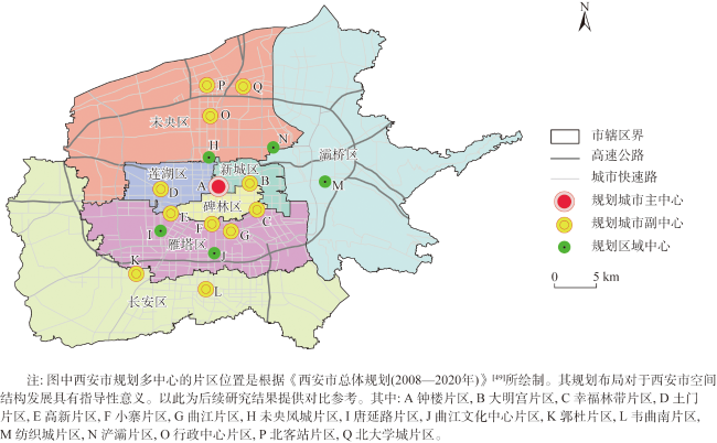
[Xi'an Natural Resources Bureau. Xi'an urban general planning(2008-2020)[S]. 2022.] http://zygh.xa.gov.cn/ywpd/cxghgsgb/ghcggs/62876060f8fd1c0bdc995ed3.html
|
| [50] |
中华人民共和国自然资源部. 《国土空间调查、规划、用途管制用地用海分类指南(试行)》[S]. 2020.
[Ministry of Natural Resources of the People's Republic of China, Land and space survey,planning, land use control sea classification guide (Trial)[S]. 2020.]https://www.gov.cn/zhengce/zhengceku/2020-11/22/content_5563311.html
|
| [51] |
段亚明, 刘勇, 刘秀华, 等. 基于宜出行大数据的多中心空间结构分析——以重庆主城区为例[J]. 地理科学进展, 2019, 38(12):1957-1967.
[
|
| [52] |
郑晓伟. 基于开放数据的西安城市中心体系识别与优化[J]. 规划师, 2017, 33(1):57-64.
[
|
| [53] |
王晓红, 李宣廷, 张少鹏. 多中心空间结构是否促进城市高质量发展?——来自中国地级城市层面的经验证据[J]. 中国人口·资源与环境, 2022, 32(5):57-67.
[
|
/
| 〈 |
|
〉 |