
综合局部莫兰指数和PageRank算法的网络空间资源节点隐喻可视化表达
|
齐 凯(1998—),男,河南周口人,硕士生,主要从事摄影测量与遥感方向的研究。E-mail: 1282030444@qq.com |
收稿日期: 2023-11-13
修回日期: 2024-01-11
网络出版日期: 2024-05-21
基金资助
国家重点研发计划项目(2016YFB0801301-2)
国家重点研发计划项目(2016YFB0801303)
Metaphor Representation of Resource Nodes in Cyberspace Based on Local Moran Index and PageRank Algorithm
Received date: 2023-11-13
Revised date: 2024-01-11
Online published: 2024-05-21
Supported by
National Key Research and Development Program of China(2016YFB0801301-2)
National Key Research and Development Program of China(2016YFB0801303)
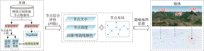
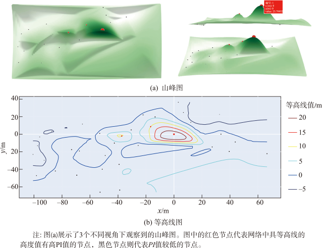
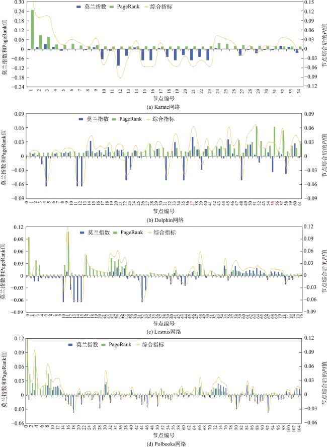
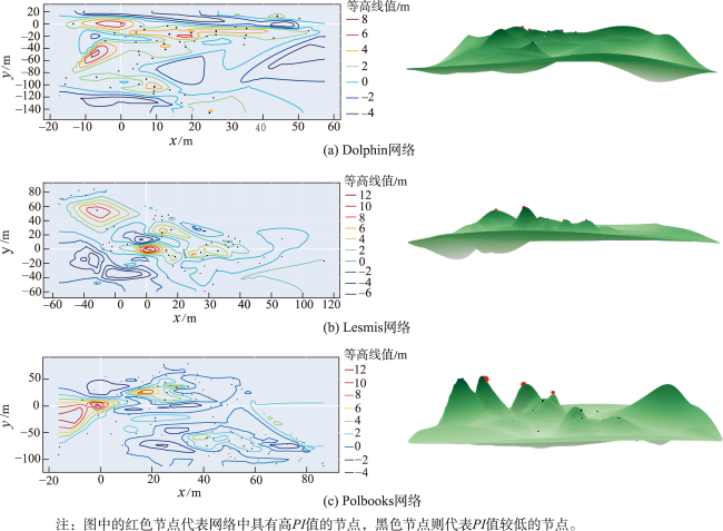
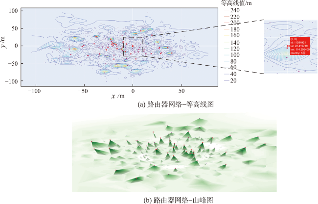
可视化是一种非常有效的网络空间资源分析方式,通过借助点线面、符号、地形等形象映射抽象数据,可以更好地管理、维护和优化网络空间。考虑到网络空间资源节点在网络中的空间相关性和重要性,本文借助隐喻地图思想,将网络空间中资源节点视为本体,传统地理空间中山峰和等高线作为喻体进行可视化表达。首先,通过节点之间的拓扑关系构建空间权重矩阵和转移矩阵,以此计算出节点的局部莫兰指数和PageRank值。为了更全面地综合考虑节点在局部和全局范围内的空间相关性和重要性,使局部莫兰指数进行标准化处理与PageRank值达到相同的取值范围后将二者结合得到综合评价指标(PI值);然后,将网络空间资源节点根据FR算法围绕重要程度最高的节点进行布局,通过PI值赋予节点高度值和大小;最后,借助隐喻地图的思进行可视化表达。实验数据表明,相较于传统的节点评价方法,该方法将用于衡量地理空间数据中是否存在空间聚集现象的莫兰指数引入到网络空间,可以突出节点中属性值较高并且与其相连节点属性值也高的节点;同时,基于隐喻地图思想进行可视化表达可以直观表现出节点在网络空间中的所处地位以及与其他节点间的相互关系,并且在针对格式化数据进行渲染时,随着网络规模的扩大隐喻地图效率优于传统拓扑图。

齐凯 , 张衡 , 周杨 , 刘一帆 , 李庆祥 . 综合局部莫兰指数和PageRank算法的网络空间资源节点隐喻可视化表达[J]. 地球信息科学学报, 2024 , 26(5) : 1283 -1295 . DOI: 10.12082/dqxxkx.2024.230673
Visualization serves as an incredibly effective method for analyzing and understanding cyberspace resources. By leveraging elements such as points, lines, surfaces, symbols, and terrain, it offers valuable insights for the management, maintenance, and optimization of cyberspace by transforming abstract data into tangible and comprehensible forms. In this context, this paper recognizes the significance of spatial relationships and the importance of resource nodes in the network and adopts the concept of a metaphorical map as a means of visualization. It draws an analogy between the resource nodes in cyberspace and the metaphorical representation of peaks and contouring lines in traditional geographic space, facilitating visual expression and understanding. The methodology proposed in this paper involves constructing spatial weight matrices and transfer matrices based on the topological relationships among nodes in cyberspace. These matrices enable the computation of indices such as the Moreland index and PageRank value for each node, which are vital metrics for evaluating the local importance of nodes within the network. To comprehensively assess the spatial correlation and significance of nodes on both local and global scales, the local Moran index is standardized, and the PageRank values are transformed to a consistent range. These standardized indices are then combined to derive a comprehensive evaluation index called the PI value. Subsequently, the network space resource nodes are arranged around the most prominent node utilizing the FR algorithm. The PI value guides the assignment of height values and sizes to each node, facilitating their visual representation. Finally, the visualization is performed using a metaphorical map that allows for an intuitive depiction of the nodes' positions in the network space and their relationships with other nodes. Our experimental results demonstrate that this method effectively incorporates the Moreland index, commonly employed to measure spatial aggregation in geospatial data, into the network space analysis. As a result, the method effectively highlights nodes and their interconnected nodes with higher attribute values. Furthermore, the visual representation based on the metaphorical map provides a natural and intuitive understanding of the nodes' positions and their interconnections in network space. It offers a means of effectively communicating complex information about the network's structure and topology. Moreover, when rendering formatted data, the efficiency of the metaphorical map exceeds that of traditional topology maps, particularly as the scale of the network expands. The metaphorical map proves to be a powerful tool for visualizing and comprehending the intricate relationships within cyberspace resources.
表1 隐喻地图关键要素及含义Tab. 1 Key elements and implications of metaphor map |
| 关键要素 | 隐喻地图含义 |
|---|---|
| 山峰 | 表示网络中重要程度较高的节点 |
| 山谷 | 表示网络中重要程度较低的节点 |
| 节点大小 | 与网络中节点重要程度成正相关 |
| 节点位置 | 围绕网络中重要程度最高的节点进行布局,表示节点在拓扑空间中相对的位置关系 |
| 等高线 | 等高线的高度与网络中节点重要程度成正相关 |
| 算法1 网络空间资源节点局部莫兰指数标准化 |
|---|
| 输入:网络空间资源节点的局部莫兰指数 输出:标准化后的局部莫兰指数 # 计算局部莫兰指数绝对值之和 abs_sum_values = 计算局部莫兰指数绝对值之和 # 将数据绝对值调整到(0,1)范围内,且所有值之和为1 adjusted_data = 将数据调整到(0,1)范围内 # 保持数据原始的正负性 Until normalized_data |
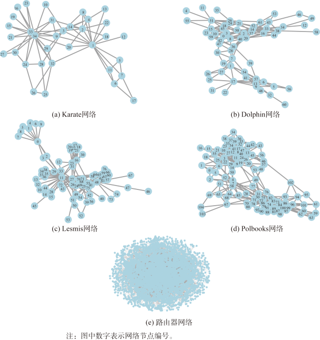
表2 网络数据集特征Tab. 2 Classic network set |
| 网络名称 | 节点数/个 | 边数/条 | 平均度 | 图密度 |
|---|---|---|---|---|
| Karate | 34 | 78 | 4.588 | 0.139 0 |
| Dolphin | 62 | 159 | 5.129 | 0.084 0 |
| Lesmis | 77 | 254 | 6.597 | 0.087 0 |
| Polbooks | 105 | 441 | 8.400 | 0.081 0 |
| 路由器网络 | 4 677 | 6 123 | 2.618 | 0.000 6 |
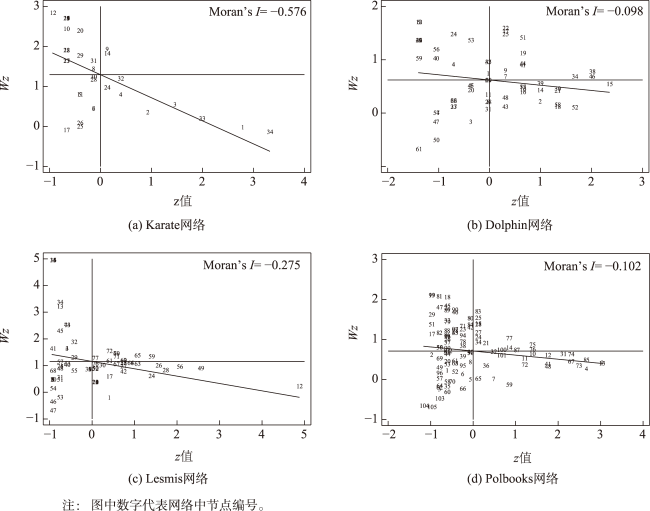
表3 经典网络在网络空间中的全局莫兰指标Tab. 3 Global Moran indicators of classical networks in cyberspace |
| 网络名称 | 全局莫兰指数I | 期望值E(I) | 标准差sd(I) | 标准差z值 | p值 |
|---|---|---|---|---|---|
| Karate | -0.576 | -0.030 | 0.101 | -5.393 | 0.000 |
| Dolphin | -0.098 | -0.016 | 0.088 | -0.922 | 0.178 |
| Lesmis | -0.275 | -0.013 | 0.075 | -3.510 | 0.000 |
| Polbooks | -0.102 | -0.010 | 0.049 | -1.892 | 0.029 |
表4 隐喻地图和传统拓扑图针对格式化数据在运行效率的对比Tab. 4 Comparison of operational efficiency of metaphor map and traditional topology map (s) |
| 网络名称 | Karate网络 | Dolphin网络 | Lesmis网络 | Polbooks网络 | 路由器网络 |
|---|---|---|---|---|---|
| 传统拓扑图 | 0.144 | 0.149 | 0.177 | 0.192 | 62.220 |
| 隐喻地图 | 1.587 | 3.216 | 2.257 | 2.319 | 5.686 |
| [1] |
李响, 杨飞, 王丽娜, 等. 网络空间地图制图方法研究综述[J]. 测绘科学技术学报, 2019, 36(6):620-626,631.
[
|
| [2] |
陈云海, 江南, 曹一冰, 等. 地图学理论在网络空间地图制图中的应用[J]. 测绘科学技术学报, 2020, 37(3):301-306.
[
|
| [3] |
孙中伟, 路紫, 王杨. 网络信息空间的地理学研究回顾与展望[J]. 地球科学进展, 2007, 22(10):1005-1011.
[
|
| [4] |
|
| [5] |
|
| [6] |
艾廷华. 大数据驱动下的地图学发展[J]. 测绘地理信息, 2016, 41(2):1-7.
[
|
| [7] |
郭妍. 隐喻思维下的空间信息表达和可视化查询设计[D]. 武汉: 武汉大学, 2009.
[
|
| [8] |
|
| [9] |
|
| [10] |
|
| [11] |
|
| [12] |
|
| [13] |
|
| [14] |
王续盘, 张衡, 周杨, 等. Blondel和k-核分解混合算法相结合的网络空间点群要素多尺度模型构建[J]. 地球信息科学学报, 2021, 23(12):2128-2138.
[
|
| [15] |
|
| [16] |
张龙. 网络资源测绘数据表达与分析技术研究[D]. 郑州: 战略支援部队信息工程大学, 2018.
[
|
| [17] |
|
| [18] |
|
| [19] |
张峥. 赛博地图构建理论研究[D]. 郑州: 解放军信息工程大学, 2012.
[
|
| [20] |
王映雪. 网络空间关系及节点信息地图可视化方法与技术研究[D]. 郑州: 战略支援部队信息工程大学, 2020.
[
|
| [21] |
|
| [22] |
|
| [23] |
蒋秉川, 万刚, 徐锐. 网络空间剖分机理与可视化方法研究[J]. 系统仿真学报, 2017, 29(S1):1-8.
[
|
| [24] |
岳香豆. 改进的标签传播社区发现算法及可视化展示[D]. 太原: 山西大学, 2020.
[
|
| [25] |
|
| [26] |
|
| [27] |
|
| [28] |
艾廷华, 禹文豪. 水流扩展思想的网络空间Voronoi图生成[J]. 测绘学报, 2013, 42(5):760-766.
[
|
| [29] |
信睿, 艾廷华, 何亚坤. Gosper地图的非空间层次数据隐喻表达与分析[J]. 测绘学报, 2017, 46(12):2006-2015.
[
|
| [30] |
高贞. 层次化语义信息的河系地图隐喻表达[D]. 武汉: 武汉大学, 2020.
[
|
| [31] |
|
| [32] |
|
| [33] |
|
| [34] |
|
| [35] |
|
| [36] |
孙婧. 长江经济带城市群旅游流时空演化与溢出效应研究[D]. 岳阳: 湖南理工学院, 2022.
[
|
| [37] |
|
| [38] |
|
| [39] |
|
| [40] |
|
| [41] |
|
/
| 〈 |
|
〉 |