
多源遥感日降水数据融合方法:顾及空间自相关的随机森林模型
|
何青鑫(1999— ),男,山东济南人,硕士生,研究方向为遥感降水产品提升。E-mail: he15966059562@163.com |
收稿日期: 2023-12-18
修回日期: 2024-01-24
网络出版日期: 2024-05-24
基金资助
山东省自然科学基金项目(ZR2020YQ26)
Fusion Method for Multi-Source Remote Sensing Daily Precipitation Data: Random Forest Model Considering Spatial Autocorrelation
Received date: 2023-12-18
Revised date: 2024-01-24
Online published: 2024-05-24
Supported by
Shandong Province Natural Science Foundation(ZR2020YQ26)
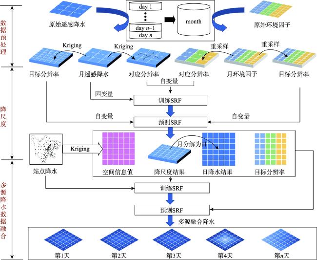
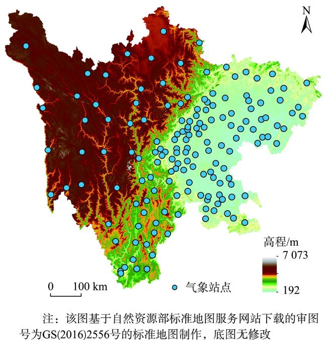
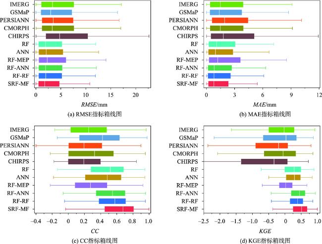
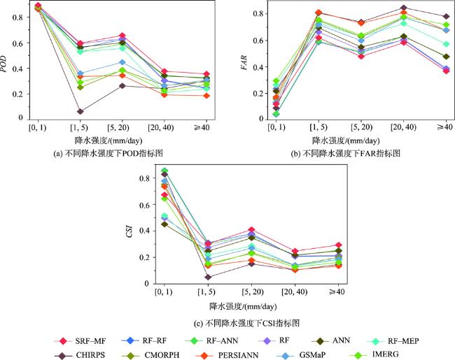
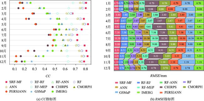
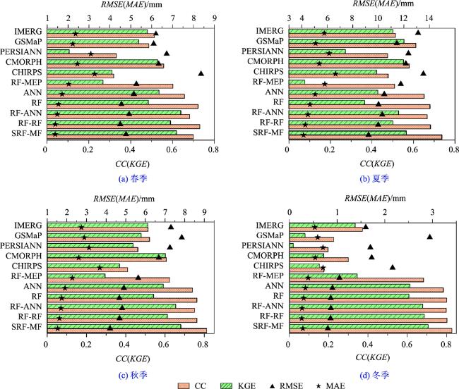
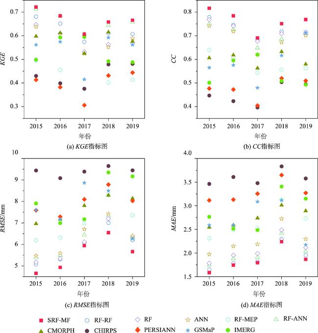
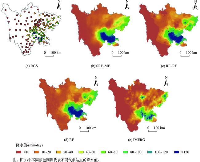
高质量的降水数据是气象服务与水文应用的基础资料保障,多时空尺度的卫星降水数据作为重要的降水数据源,现已被广泛应用到水文气象领域。然而,卫星降水产品存在空间分辨率粗糙、准确性差等问题,难以满足精细化水文和气象的应用需求。本文以随机森林(Random Forest,RF)为基础模型,提出一种顾及空间自相关性的多源遥感日降水数据融合方法(Spatial Random Forest Multi-source Fusion, SRF-MF)。该方法首先基于降水与环境因子之间存在较强的相关性,在月尺度上利用空间随机森林对多种卫星降水产品分别进行降尺度,然后根据日比率将月降水分解为日降水,最后借助随机森林将降尺度数据和站点数据融合,最终生成高质量的日降水数据。利用2015—2019年四川省5种卫星降水产品(CHIRPS、CMORPH、PERSIANN、GAMaP和IMERG)和实测雨量计数据,通过SRF-MF方法生成了逐日降水数据集,并将该数据集与原始卫星降水产品和5种机器学习方法比较,包括随机森林合并方法(RF-MEP)、单机器学习方法(RF、ANN)和双机器学习方法(RF-RF、RF-ANN)。实验结果表明,在不同时间尺度上(日、月、季、年)SRF-MF方法产生的降水数据集精度均明显优于其他几种方法,而且针对不同强度降水事件的捕捉精度更高,其降水分布图的空间细节信息更加丰富,准确性更高。本文研究结果将为提高卫星降水数据质量,以及扩大应用领域提供研究思路。

何青鑫 , 陈传法 , 王宇辉 , 孙延宁 , 刘雅婷 , 胡保健 . 多源遥感日降水数据融合方法:顾及空间自相关的随机森林模型[J]. 地球信息科学学报, 2024 , 26(6) : 1517 -1530 . DOI: 10.12082/dqxxkx.2024.230752
High-quality precipitation data is essential to guarantee meteorological services and hydrological applications. As an important source of precipitation data, satellite precipitation data, at various spatial and temporal scales, has been widely used in the field of hydrology and meteorology. However, satellite precipitation products often suffer from issues such as coarse spatial resolution and low accuracy, hindering their suitability for refined hydrological and meteorological applications. This study uses Random Forest (RF) as the basic model and proposes a spatial Random Forest multi-source fusion (SRF-MF) method to fuse daily precipitation data.This method first uses spatial random forest to downscale various satellite precipitation products on a monthly scale, leveraging the strong correlation between precipitation and environmental factors. Then it decomposes the monthly precipitation into daily values based on daily ratios. Finally, it uses RF to fuse downscaled data and site data to ultimately generate high-quality daily precipitation data. Using five satellite precipitation products (CHIRPS, CMORPH, PERSIANN, GAMaP and IMERG), along with rain gauge data from Sichuan Province spanning from 2015 to 2019, the SRF-MF method generated a daily precipitation dataset. This dataset was compared with the original satellite precipitation and five machine learning methods, including Random Forest Merging method (RF-MEP), single machine learning method (RF, ANN), and dual machine learning method (RF-RF, RF-ANN). Experimental results demonstrate that the precipitation dataset generated by the SRF-MF method exhibits significantly higher accuracy compared to several other methods across different time scales (daily, monthly, quarterly, yearly), with greater precision in capturing precipitation events of varying intensities. Moreover, the spatial details of the precipitation distribution map are richer and more accurate. The findings of this article provide research ideas for improving the quality of satellite precipitation data and expanding its application fields.
Key words: precipitation; multi-source data; autocorrelation; fusion; daily scale; machine learning; downscaling; refinement
表1 卫星降水产品基本信息Tab. 1 Basic information of satellite precipitation products |
| 数据 | 分辨率 | 时段/年 | 来源 |
|---|---|---|---|
| IMERG_Final | 0.1 °/d | 2015—2019 | https://disc.gsfc.nasa.gov/datasets?keywords=IMERG&page=1 |
| GSMaP_Gauge | 0.1 °/h | 2015—2019 | https://sharaku.eorc.jaxa.jp/GSMaP/index.html |
| CMORPH | 0.25 °/d | 2015—2019 | https://www.ncei.noaa.gov/products/climate-data-records/precipitation-cmorph |
| CHIRPS | 0.05 °/d | 2015—2019 | https://chc.ucsb.edu/data/chirps |
| PERSIANN | 0.25 °/d | 2015—2019 | http://chrsdata.eng.uci.edu/ |
表2 环境驱动因子基本信息Tab. 2 Basic information of environment drivers |
| 数据 | 分辨率 | 时段/年 | 来源 |
|---|---|---|---|
| DEM | 90 m | 2015—2019 | https://www.gscloud.cn/ |
| NDVI | 1 km/月 | 2015—2019 | https://ladsweb.modaps.eosdis.nasa.gov |
| LST | 1 km/8d | 2015—2019 | https://ladsweb.modaps.eosdis.nasa.gov |
| 2 m-temperature | 10 km/h | 2015—2019 | https://cds.climate.copernicus.eu/cdsapp#!/dataset/ |
| [1] |
|
| [2] |
熊立华, 刘成凯, 陈石磊, 等. 遥感降水资料后处理研究综述[J]. 水科学进展, 2021, 32(4):627-637.
[
|
| [3] |
|
| [4] |
杜晓婉, 陈曦, 郑宏伟, 等. 一种降水降尺度模型:地形约束下的条件生成对抗网络[J]. 地球信息科学学报, 2023, 25(8):1586-1600.
[
|
| [5] |
|
| [6] |
|
| [7] |
高歆, 袁胜元, 李京忠, 等. 面向稀疏降水站点的套合各向异性贝叶斯地统计估计研究[J]. 地球信息科学学报, 2022, 24(8):1445-1458.
[
|
| [8] |
|
| [9] |
|
| [10] |
|
| [11] |
|
| [12] |
|
| [13] |
|
| [14] |
|
| [15] |
|
| [16] |
胡保健, 李伟, 陈传法, 等. 利用空间随机森林方法提升GPM卫星遥感降水质量[J]. 遥感学报, 2024, 128(2):414-425.
[
|
| [17] |
|
| [18] |
|
| [19] |
张良培, 何江, 杨倩倩, 等. 数据驱动的多源遥感信息融合研究进展[J]. 测绘学报, 2022, 51(7):1317-1337.
[
|
| [20] |
|
| [21] |
|
| [22] |
|
| [23] |
|
| [24] |
|
| [25] |
|
| [26] |
|
| [27] |
|
| [28] |
|
| [29] |
|
| [30] |
祝新明, 宋小宁, 冷佩, 等. 多尺度地理加权回归的地表温度降尺度研究[J]. 遥感学报, 2021, 25(8):1749-1766.
[
|
| [31] |
|
| [32] |
|
| [33] |
|
| [34] |
张梅霞. 广安市近60年气候变化特征研究[D]. 成都: 四川师范大学, 2022.
[
|
/
| 〈 |
|
〉 |