
主体功能视角下耦合马尔可夫链和PLUS模型的城镇开发边界划定研究
|
梁毅东(1997— ),男,山西临汾人,硕士生,主要从事国土空间规划。E-mail: 20212201133@kust.edu.cn。 |
Copy editor: 蒋树芳
收稿日期: 2024-01-29
修回日期: 2024-03-02
网络出版日期: 2024-06-25
基金资助
国家自然科学基金项目(42301304)
云南省基础研究计划项目(202201AU070112)
Research on Urban Development Boundary Delineation Using Coupled Markov Chain and PLUS Models from the Perspective of Main Functions
Received date: 2024-01-29
Revised date: 2024-03-02
Online published: 2024-06-25
Supported by
National Natural Science Foundation of China(42301304)
Yunnan Fundamental Research Projects(202201AU070112)
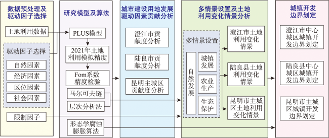
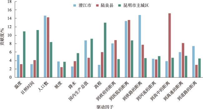
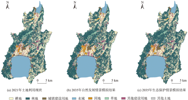
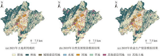
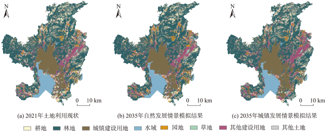
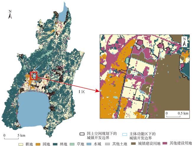
城镇开发边界对城市未来的土地利用和国土空间格局有指导和约束作用,主体功能定位是制定国土空间开发保护战略措施的基础,而现有城镇开发边界划定研究对主体功能的影响考虑不足。本文基于2009—2021年土地利用数据,选取重点生态功能区(澄江市)、农产品主产区(陆良县)、城市化地区(昆明市主城区)3种典型主体功能区域,耦合PLUS模型、匀速递增马尔可夫链和层次分析法,依据主体功能类型分别按照生态保护、农业生产、城镇发展情景进行2035年土地利用变化模拟和城镇开发边界的划定,并提出数量及空间格局优化方案。结果表明: ① 不同类型主体功能区城镇建设用地变化影响因素存在差异,重点生态功能区和农产品主产区主要受社会因素的影响,城市化地区主要受自然因素的影响; ② 提出匀速递增马尔可夫链对土地利用进行数量模拟,精度超过96%。通过PLUS模型对3种类型土地利用进行预测, Fom值介于0.1~0.3之间。耦合模型能较好的反映未来土地利用变化情况; ③ 对不同主体功能类型的城镇建设用地进行模拟分析以及对划定的城镇开发边界与实际划定结果进行对比,提出澄江市应缩减边界规模,陆良县应进行布局优化,避让连片耕地并适当缩减边界规模,昆明主城区边界规模合理,但空间布局局部可以优化;城镇开发边界的划定应考虑不同主体功能定位,不能简单用一个统一的扩展倍数来限定。本文提出了在主体功能战略背景下的城镇开发边界划定的一种改进模型与耦合方法,可为政府相关部门开展具体工作提供依据。
梁毅东 , 张述清 , 朱大明 , 李永平 . 主体功能视角下耦合马尔可夫链和PLUS模型的城镇开发边界划定研究[J]. 地球信息科学学报, 2024 , 26(7) : 1702 -1716 . DOI: 10.12082/dqxxkx.2024.240064
The urban development boundary guides and restricts the future land use and territorial spatial pattern of the city. The positioning of main functions is the basis for formulating strategic measures for territorial spatial development and protection. However, existing urban development boundary delineation research does not take into account the impact of main functions. Based on land use data from 2009 to 2021, this article selects three typical main functional areas: key ecological functional areas in Chengjiang City, main agricultural product production areas in Luliang County, and urbanized areas within main urban area of Kunming City. The coupled PLUS model, uniformly increasing Markov chain, and analytic hierarchy process are used to simulate land use changes and delineate urban development boundaries in 2035 according to ecological protection, agricultural production, and urban development scenarios according to the main function types, and further put forward the quantity and spatial pattern optimization plans. Results show that: 1) There are differences in the influencing factors of changes in urban construction land in different types of main functional areas. Key ecological functional areas and main agricultural product production areas are mainly affected by social factors, while urbanized areas are mainly affected by natural factors; 2) A uniformly increasing Markov chain is proposed to quantitatively simulate land use, with an accuracy exceeding 96%. Three types of land use are predicted through the PLUS model, and the Fom value ranges from 0.1 to 0.3. The coupled model can better reflect future land use changes; 3) We carry out simulation analysis of urban construction land with different main functional types and compare the delineated urban development boundaries with the actual demarcation results. It is proposed that Chengjiang City should reduce the boundary scale, Luliang County should optimize the layout, avoid contiguous cultivated land and appropriately reduce the boundary scale, and the boundary scale of Kunming's main urban area is reasonable, but the spatial layout can be optimized in part. The delineation of urban development boundaries should take into account the functional positioning of different entities and cannot simply be limited by a unified expansion multiple. This article proposes an improved model and coupling method for urban development boundary delineation in the context of the main function strategy, which can provide a basis for relevant government departments to carry out specific work.
表1 土地利用变化中驱动因子及限制因子Tab. 1 Driving factors and limiting factors in land use change |
| 驱动/限制 | 因素 | 分类 |
|---|---|---|
| 驱动因子 | 自然因素 | 降水、温度、日照时间、高程、坡度 |
| 经济因素 | 国内生产总值 | |
| 区位因素 | 河流、铁路、高速公路、主要道路 | |
| 社会因素 | 政府、医院、学校、人口 | |
| 限制因子 | 生态保护红线、永久基本农田 |
表2 2035年不同情景下的地类面积Tab. 2 Land type area under different scenarios in 2035 (km2) |
| 研究区 | 情景 | 耕地 | 园地 | 林地 | 草地 | 城镇建设用地 | 其他建设用地 | 水域 | 其他土地 |
|---|---|---|---|---|---|---|---|---|---|
| 澄江市 | 自然发展 | 153.74 | 21.12 | 353.29 | 29.03 | 12.24 | 38.77 | 146.87 | 1.39 |
| 生态保护 | 153.74 | 15.12 | 368.16 | 25.39 | 11.76 | 34.01 | 146.87 | 1.39 | |
| 陆良县 | 自然发展 | 816.80 | 107.46 | 732.84 | 49.54 | 40.39 | 180.48 | 40.21 | 21.06 |
| 农业生产 | 860.49 | 106.84 | 704.66 | 49.54 | 32.81 | 156.74 | 53.49 | 24.21 | |
| 昆明市主城区 | 自然发展 | 296.84 | 169.97 | 1 660.94 | 93.13 | 429.05 | 303.87 | 239.8 | 12.17 |
| 城镇发展 | 303.43 | 114.42 | 1 604.53 | 93.13 | 488.65 | 344.16 | 245.26 | 12.17 |
表3 不同情景下的邻域权重Tab. 3 Domain weights under different scenarios |
| 情景 | 耕地 | 园地 | 林地 | 草地 | 城镇建设用地 | 其他建设用地 | 水域 | 其他土地 |
|---|---|---|---|---|---|---|---|---|
| 生态保护 | 13.80 | 5.94 | 16.49 | 2.20 | 29.96 | 15.78 | 12.08 | 3.76 |
| 农业生产 | 27.02 | 6.30 | 12.84 | 2.05 | 25.86 | 11.31 | 10.67 | 3.95 |
| 城镇发展 | 10.48 | 6.20 | 10.48 | 1.83 | 42.13 | 17.75 | 8.10 | 3.04 |
表4 不同情景下的转换成本矩阵Tab. 4 Shows the conversion cost matrix under different scenarios |
| 地类编号 | 分区 | 1 | 2 | 3 | 4 | 5 | 6 | 7 | 8 | 分区 | 1 | 2 | 3 | 4 | 5 | 6 | 7 | 8 |
|---|---|---|---|---|---|---|---|---|---|---|---|---|---|---|---|---|---|---|
| 1 | 1 | 1 | 1 | 1 | 0 | 1 | 1 | 0 | 0 | 2 | 1 | 1 | 1 | 0 | 1 | 1 | 0 | 0 |
| 2 | 1 | 1 | 1 | 0 | 1 | 1 | 0 | 0 | 1 | 1 | 1 | 0 | 1 | 1 | 0 | 0 | ||
| 3 | 1 | 1 | 1 | 0 | 1 | 1 | 0 | 0 | 0 | 0 | 1 | 0 | 0 | 0 | 0 | 0 | ||
| 4 | 1 | 1 | 1 | 1 | 1 | 1 | 0 | 0 | 1 | 0 | 1 | 1 | 1 | 1 | 0 | 0 | ||
| 5 | 0 | 0 | 0 | 0 | 1 | 0 | 0 | 0 | 0 | 0 | 0 | 0 | 1 | 0 | 0 | 0 | ||
| 6 | 1 | 1 | 1 | 0 | 1 | 1 | 0 | 0 | 0 | 1 | 1 | 1 | 1 | 1 | 0 | 0 | ||
| 7 | 0 | 0 | 0 | 0 | 0 | 1 | 1 | 0 | 0 | 0 | 0 | 0 | 0 | 0 | 1 | 0 | ||
| 8 | 1 | 1 | 1 | 1 | 1 | 1 | 0 | 1 | 0 | 0 | 1 | 1 | 1 | 0 | 0 | 1 | ||
| 1 | 3 | 1 | 1 | 1 | 0 | 1 | 1 | 0 | 1 | 4 | 1 | 0 | 0 | 0 | 1 | 0 | 0 | 0 |
| 2 | 1 | 1 | 1 | 0 | 1 | 1 | 0 | 1 | 1 | 1 | 1 | 0 | 1 | 1 | 0 | 1 | ||
| 3 | 1 | 1 | 1 | 0 | 1 | 1 | 0 | 1 | 1 | 1 | 1 | 0 | 1 | 1 | 0 | 1 | ||
| 4 | 1 | 1 | 1 | 1 | 1 | 1 | 0 | 1 | 1 | 1 | 1 | 1 | 1 | 1 | 0 | 0 | ||
| 5 | 0 | 0 | 0 | 0 | 1 | 0 | 0 | 0 | 0 | 0 | 0 | 0 | 1 | 0 | 0 | 0 | ||
| 6 | 1 | 1 | 1 | 0 | 1 | 1 | 0 | 1 | 1 | 0 | 0 | 0 | 1 | 1 | 0 | 1 | ||
| 7 | 1 | 1 | 1 | 1 | 1 | 1 | 1 | 1 | 1 | 0 | 0 | 0 | 0 | 0 | 1 | 0 | ||
| 8 | 1 | 1 | 1 | 1 | 1 | 1 | 0 | 1 | 1 | 0 | 0 | 0 | 0 | 1 | 0 | 1 | ||
| 1 | 5 | 1 | 1 | 1 | 1 | 1 | 1 | 0 | 0 | 6 | 1 | 1 | 1 | 1 | 1 | 1 | 0 | 0 |
| 2 | 1 | 1 | 1 | 1 | 1 | 1 | 0 | 0 | 1 | 1 | 1 | 1 | 1 | 1 | 0 | 0 | ||
| 3 | 1 | 1 | 1 | 1 | 1 | 1 | 0 | 0 | 1 | 0 | 1 | 0 | 1 | 1 | 0 | 0 | ||
| 4 | 1 | 1 | 1 | 1 | 1 | 1 | 0 | 0 | 1 | 1 | 1 | 1 | 1 | 1 | 0 | 0 | ||
| 5 | 0 | 1 | 1 | 0 | 1 | 1 | 0 | 0 | 0 | 0 | 0 | 0 | 1 | 0 | 0 | 0 | ||
| 6 | 1 | 1 | 1 | 1 | 1 | 1 | 0 | 0 | 0 | 0 | 1 | 1 | 1 | 1 | 0 | 0 | ||
| 7 | 1 | 1 | 1 | 1 | 0 | 0 | 1 | 0 | 0 | 0 | 0 | 0 | 0 | 0 | 1 | 0 | ||
| 8 | 1 | 1 | 1 | 1 | 1 | 1 | 0 | 1 | 0 | 0 | 0 | 1 | 1 | 1 | 0 | 1 |
注:地类1-耕地;地类2-园地;地类3-林地;地类4-草地;地类5-城镇建设用地;地类6-其他建设用地;地类7-水域;地类8-其他土地。分区1,分区3,分区5-不同主体功能区中的自然发展情景;分区2-生态保护场景;分区4-农业生产情景;分区6-城镇发展情景。 |
| [1] |
乔岩, 焦利民. 全球视角下城市形态对交通碳排放的影响[J]. 地理研究, 2023, 42(12):3202-3218.
[
|
| [2] |
张运平, 林建平, 黄艺敏, 等. 基于PLUS空间决策模型的城镇与农业空间协调布局优化[J]. 农业工程学报, 2023, 39(20):233-243.
[
|
| [3] |
丛婷婷, 戴昭鑫, 武鹏达, 等. 基于FLUS-UGB模型的城镇开发边界预测研究——以滨州市为例[J]. 测绘与空间地理信息, 2023, 46(8):30-35.
[
|
| [4] |
宋晓杰, 周艳妮. 新时期城镇开发边界内详细规划管理制度建设探讨——基于武汉市控规管理的实践思考[J]. 城乡规划, 2023(4):10-20.
[
|
| [5] |
张宇硕, 吴殿廷, 吕晓. 土地利用/覆盖变化对生态系统服务的影响:空间尺度视角的研究综述[J]. 自然资源学报, 2020, 35(5):1172-1189.
[
|
| [6] |
程茂吉. 从空间蓝图走向管制规划:市级国土空间总体规划的实践和探索[J]. 城市发展研究, 2023, 30(10):8-16,35.
[
|
| [7] |
张兵, 林永新, 刘宛, 等. 城镇开发边界与国家空间治理——划定城镇开发边界的思想基础[J]. 城市规划学刊, 2018(4):16-23.
[
|
| [8] |
高晓路, 吴丹贤, 周侃, 等. 国土空间规划中城镇空间和城镇开发边界的划定[J]. 地理研究, 2019, 38(10):2458-2472.
[
|
| [9] |
张韶月, 刘小平, 闫士忠, 等. 基于“双评价” 与FLUS-UGB的城镇开发边界划定——以长春市为例[J]. 热带地理, 2019, 39(3):377-386.
[
|
| [10] |
张世伟, 魏璐瑶, 金星星, 等. 基于FLUS-UGB的县域土地利用模拟及城镇开发边界划定研究[J]. 地球信息科学学报, 2020, 22(9):1848-1859.
[
|
| [11] |
赵轩, 彭建东, 樊智宇, 等. “双评价” 视角下基于FLUS模型的武汉大都市区土地利用模拟和城镇开发边界划定研究[J]. 地球信息科学学报, 2020, 22(11):2212-2226.
[
|
| [12] |
娄佳乐, 党晓宏, 蒙仲举, 等. 1986—2020年黄河流域十大孔兑土地利用变化及驱动力分析[J]. 水土保持学报, 2024, 38(1):319-327,336.
[
|
| [13] |
杜怀玉, 俞金凤, 张媛, 等. 石羊河流域多情景土地利用优化及碳储量评估[J]. 环境科学:1-25.
[
|
| [14] |
史宇微, 杨朝现, 信桂新, 等. 山地丘陵区潜在土地利用冲突——以重庆市江津区为例[J]. 水土保持研究, 2021, 28(5):316-324.
[
|
| [15] |
帕茹克·吾斯曼江, 艾东, 方一舒, 等. 基于InVEST与CA-Markov模型的昆明市碳储量时空演变与预测[J]. 环境科学, 2024, 45(1):287-299.
[
|
| [16] |
|
| [17] |
|
| [18] |
|
| [19] |
|
| [20] |
唐华俊, 吴文斌, 杨鹏, 等. 土地利用/土地覆被变化(LUCC)模型研究进展[J]. 地理学报, 2009, 64(4):456-468.
[
|
| [21] |
|
| [22] |
刘海龙, 王跃飞, 谢亚林, 等. 太原城市群三生空间时空演变特征及功能[J]. 水土保持通报, 2020, 40(5):310-318,327.
[
|
| [23] |
黄安, 许月卿, 卢龙辉, 等. “生产-生活-生态” 空间识别与优化研究进展[J]. 地理科学进展, 2020, 39(3):503-518.
[
|
| [24] |
夏陈红, 翟国方. 基于GBDT机器学习算法的国土空间演变动力机制研究——以长江三角洲为例[J]. 城市发展研究, 2022, 29(11):12-19.
[
|
| [25] |
黄金川, 林浩曦, 漆潇潇. 面向国土空间优化的三生空间研究进展[J]. 地理科学进展, 2017, 36(3):378-391.
[
|
| [26] |
周小平, 李理, 梁颖, 等. 主体功能区视角下长三角地区国土空间格局时空演变及其碳排放效应分析[J]. 农业工程学报, 2023, 39(17):236-244.
[
|
| [27] |
孙博, 吴雨珂, 闫白冰, 等. 1990—2020年淮河生态经济带耕地资源分布变化特征与驱动机制[J]. 农业工程学报, 2023, 39(23):247-258.
[
|
| [28] |
周霞, 王佳. 京津冀城市群城市韧性时空演变特征及空间差异研究——基于改进的PSR框架[J]. 资源开发与市场:1-13.
[
|
| [29] |
王亚飞, 樊杰, 周侃. 基于“双评价” 集成的国土空间地域功能优化分区[J]. 地理研究, 2019, 38(10):2415-2429.
[
|
| [30] |
云南省自然资源厅. 云南省国土空间规划(2021—2035 年)[Z]. 2021.
[ Yunnan Provincial Department of Natural Resources. Territorial spatial planning of Yunnan Province (2021—2035)[Z]. 2021.]
|
| [31] |
|
| [32] |
|
| [33] |
郭仁韵, 刘小平, 许晓聪. 洪灾风险规避下的珠三角未来城市扩张模拟和灾损减缓评估[J]. 热带地理, 2023, 43(6):1083-1097.
[
|
| [34] |
|
| [35] |
郭金玉, 张忠彬, 孙庆云. 层次分析法的研究与应用[J]. 中国安全科学学报, 2008, 18(5):148-153.
[
|
| [36] |
王杰云, 罗志军, 俞林中, 等. 基于适宜性评价与Agent-CA模型的城镇开发边界划定——以江西省安义县为例[J]. 地域研究与开发, 2022, 41(5):70-76.
[
|
/
| 〈 |
|
〉 |