
城市低空通行役权概念建模方法
|
李程鹏(1992— ),男,湖南郴州人,博士,研究方向为三维GIS与建模、智慧城市与可视化等。E-mail: lichengpeng@szu.edu.cn |
Copy editor: 黄光玉
收稿日期: 2024-04-14
修回日期: 2024-06-05
网络出版日期: 2024-07-24
基金资助
国家自然科学基金项目(42171265)
国家自然科学基金项目(62394335)
广东省基础与应用基础研究基金项目(2022A1515012120)
Conceptual Modeling Method for Urban Low-Altitude Passage Easement
Received date: 2024-04-14
Revised date: 2024-06-05
Online published: 2024-07-24
Supported by
National Natural Science Foundation of China(42171265)
National Natural Science Foundation of China(62394335)
Basic and Applied Basic Research Foundation of Guangdong(2022A1515012120)
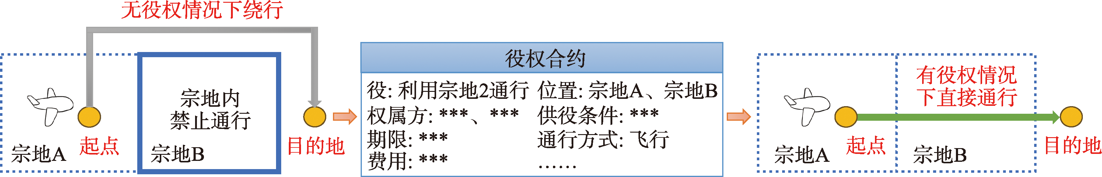
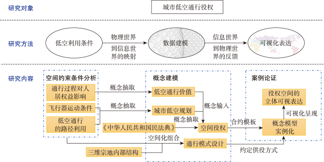
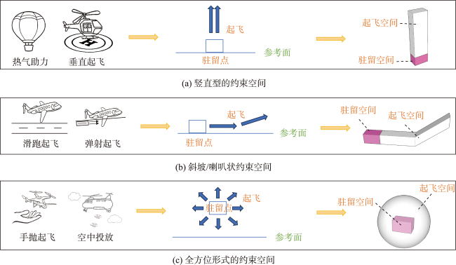
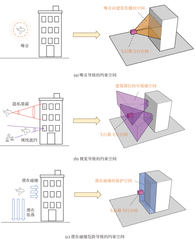
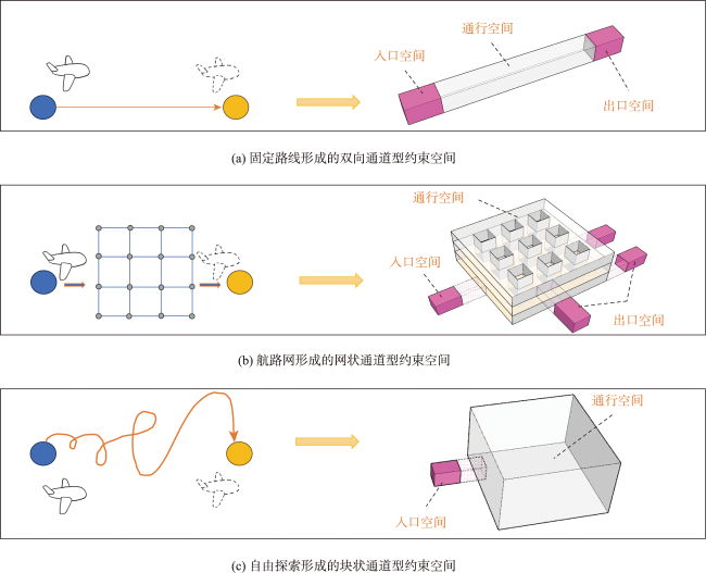
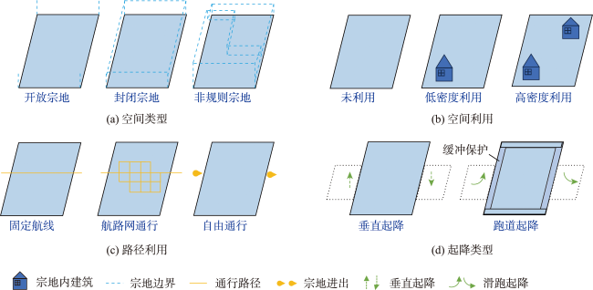
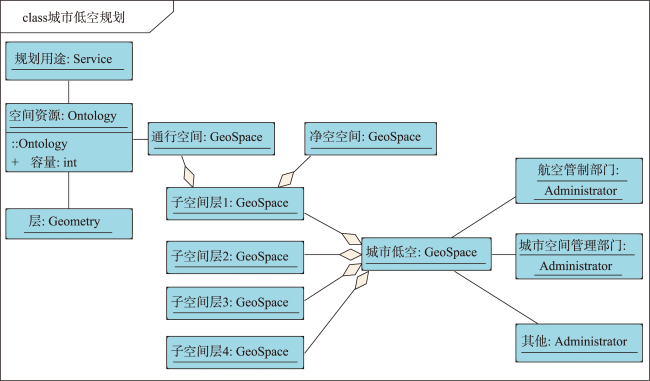
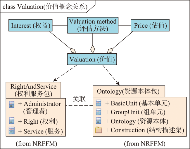
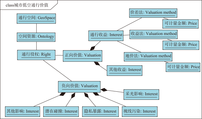
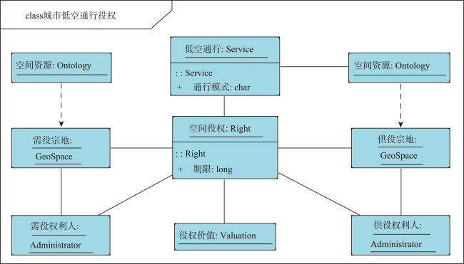
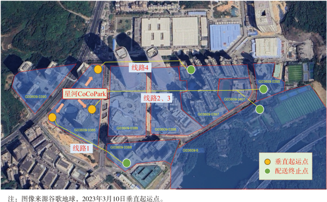
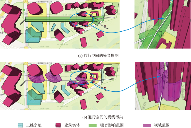
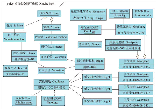
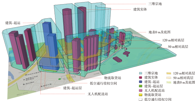
低空作为城市空间的重要组成,是精细化城市空间管理的目标对象,通过空间坐标进行位置刻画,具备显著地理基因。随着城市低空应用的日益增多,以低空通行为代表形成的复杂空间利用情况已经突破传统空域,介入城市贴地表空间,影响城市建筑和人居环境权益,突显三维土地空间的役使问题。在城市的土地管理方面,宗地被用作管理城市土地空间的基本单元,承载权属关系及空间权益信息,宗地之间构建地役权可以确保权属方对他属空间的合法利用。由于贴地表的低空飞行活动已经进入城市土地空间的管理范围,厘清低空通行过程对宗地空间的利用和影响,构建城市低空通行役权是保障低空权益的迫切需求。常规地役权概念受限于土地平面认知约束,忽视立体空间的建模与表达,城市低空作为立体空间因低空通行活动而形成地役权关系时难以被清晰描述,如何实现低空通行役权的建模与表达成为关键。采用GIS技术对城市空间进行建模,实现物理世界到数字世界的特征刻画与映射是城市空间管理的重要信息化手段。本文以概念建模为目标,提出城市低空通行役权概念建模方法:通过剖析城市低空通行中飞行器运动条件、低空通行的人居权益影响、路径利用,来实现低空通行役权的约束性空间建模,作为概念模型的几何描述;以三维宗地的空间类型为基础,结合宗地内空间利用情况、飞行器起降模式和路径利用情况探讨宗地的供役条件,形成面向通行需求的宗地供役模式;抽取现有研究和法规中关于低空通行的概念,建立低空规划、价值和役权3个方面的语义关系,形成概念模型;最后,采用深圳市的低空物流案例进行实验论证,完成模型实例化与三维视图呈现。结果表明,围绕概念模型实现的“空间利用条件-数据建模-可视化表达”一体化方案能够清晰刻画城市低空通行役权和表达城市土地空间在低空通行情景下的权益关系,为城市低空管理提供支持。
李程鹏 , 郭仁忠 , 赵志刚 , 贺彪 , 蒯希 , 王伟玺 , 陈学业 . 城市低空通行役权概念建模方法[J]. 地球信息科学学报, 2024 , 26(8) : 1811 -1826 . DOI: 10.12082/dqxxkx.2024.240207
Low-altitude space is an important component of urban space. Requisite measures for precise and meticulous management of urban low-altitude are indispensable. The urban low-altitude space should be characterized by spatial coordinates and possess significant geographic attributes. With the increasing adoption of low-altitude applications in urban areas, the intricate utilization of space, represented by low-altitude traffic, has transcended conventional airspace boundaries and encroached upon near-ground urban space, exerting an impact on urban architecture and human settlement environment. Emphasizing the 3D land space's utilization and service, the issue of the utilization and management of 3D land space has become increasingly conspicuous. The land parcel serves as the fundamental unit for urban land management, recording information of ownership relationships, spatial rights, and interests information. The establishment of easements between land parcels ensures the lawful utilization of relevant spaces. Given the inclusion of low-altitude flight activities within the purview of urban land management, there is an urgent imperative to elucidate the spatial utilization and impact of low-altitude passage processes on land space while establishing the service rights of urban low-altitude passage to safeguard parcel interests. However, the concept of easement is limited by the cognitive constraints imposed by a 2D land plane, neglecting the modeling and representation of 3D space. Precisely articulating the easement relationship formed by low-altitude passage activities in urban low-altitude space poses a significant challenge. Utilizing GIS technology for modeling urban spaces and facilitating the characterization and mapping from the physical to digital realms has consistently served as a crucial information tool in urban space management. Drawing upon the core principles of GIS modeling methodology and conceptual modeling, this paper presents a conceptual approach for describing low-altitude passage easement in urban areas. By analyzing the movement conditions of aircraft in urban low-altitude traffic, considering the impact on human settlement rights caused by overflight, and examining the path utilization of aircraft in three-dimensional space, we develop a constrained spatial modeling for low-altitude passage easement as a geometric description of the conceptual model. By integrating the spatial characteristics of 3D land parcels, we integrate the supply and service conditions of these parcels in terms of their space utilization, aircraft takeoff and landing modes, and path utilization. As a result, we propose a comprehensive supply and service model to address the demand for traffic within 3D parcels. The semantic relationship among low-altitude planning, space value, and space easement is established by extracting the concept of low-altitude access from existing research and regulations, thereby forming a conceptual model. Finally, we conduct an experimental demonstration using a logistics transportation case study in Shenzhen to instantiate the model and achieve 3D visualization. The findings demonstrate that the integrated approach of "space utilization conditions-data modeling-visual expression", implemented around the conceptual model, effectively describes urban low-altitude passage easement and conveys the equitable relationship of urban land space in low-altitude application scenarios, thereby providing valuable support for urban low-altitude management.
| [1] |
杜茎深, 陈箫, 于凤瑞. 土地立体利用的产权管理路径分析[J]. 中国土地科学, 2020, 34(2):1-8.
[
|
| [2] |
郭仁忠, 罗平, 罗婷文. 土地管理三维思维与土地空间资源认知[J]. 地理研究, 2018, 37(4):649-658.
[
|
| [3] |
廖小罕, 黄耀欢, 徐晨晨. 面向无人机应用的低空空域资源研究探讨[J]. 地理学报, 2021, 76(11):2607-2620.
[
|
| [4] |
中华人民共和国国务院, 中华人民共和国中央军事委员会. 无人驾驶航空器飞行管理暂行条例. 2023-06-28.
[ The State Council of the PRC, the Central Military Commission of the PRC. Interim Regulations on Flight Management of Unmanned Aircraft. 2023-06-28.]
|
| [5] |
世界高层建筑与都市人居学会. 城市[EB/OL]. 2023-12-31. https://www.skyscrapercenter.com/cities
[ Council on Tall Buildings and Urban Habitat. Cities[EB/OL]. 2023-12-31. https://www.skyscrapercenter.com/cities.]
|
| [6] |
深圳市人民代表大会常务委员会. 深圳经济特区低空经济产业促进条例. 2024-01-03.
[ The Standing Committee of Shenzhen Municipal People's Congress. Regulations of the Shenzhen on the Promotion of Low-altitude Economic Industries. 2024-01-03.]
|
| [7] |
深圳特区报. 深圳市支持低空经济高质量发展的若干措施[N]. 深圳特区报, 2023-12-28(A08).
[ Shenzhen Special Zone Daily. Several measures to support the high-quality development of the low-altitude economy in Shenzhen[N]. Shenzhen Special Zone Daily, 2023-12-28(A08) ]
|
| [8] |
张卫彬, 江昊. 空域的概念刍议[J]. 北京航空航天大学学报(社会科学版), 2021, 34(3):127-133.
[
|
| [9] |
王立志. 论空域权:以与空间权的比较为核心[J]. 法律科学(西北政法大学学报), 2017, 35(4):124-132.
[
|
| [10] |
江昊. 低空空域权与空间权的冲突调和路径[J]. 郑州航空工业管理学院学报(社会科学版), 2020, 39(3):23-31.
[
|
| [11] |
刘承承, 朱海红, 李霖. 融合建筑物所有权及其附属权利的LADM-BIM数据模型研究[J]. 地球信息科学学报, 2024, 26(5):1229-1242.
[
|
| [12] |
|
| [13] |
李晏良, 刘兰华, 李志强. 基于地理信息系统的高速铁路噪声地图绘制技术[J]. 中国铁道科学, 2022, 43(1):182-188.
[
|
| [14] |
|
| [15] |
|
| [16] |
|
| [17] |
|
| [18] |
廖小罕, 张捷, 黄耀欢. 浅析低空地理学的特征及其对地理学的 拓展[J]. 地理学报, 2024, 79(3):551-564.
[
|
| [19] |
应申, 孙寒蕊, 李程鹏, 等. 建筑三维产权体空间关系剖析[J]. 地理信息世界, 2021, 28(6):38-43.
[
|
| [20] |
应申, 郭仁忠, 李霖. 应用3DGIS实现三维地籍:实践与挑战[J]. 测绘地理信息, 2018, 43(2):1-6.
[
|
| [21] |
|
| [22] |
李程鹏. 土地立体化管理中的空间单元形式探讨[J]. 智能城市, 2022, 8(9):47-49.
[
|
| [23] |
李程鹏. 面向全周期土地立体化管理的流程建模[J]. 武汉大学学报(信息科学版), 2023, 48(12):2109.
[
|
| [24] |
林亨贵, 郭仁忠. 三维地籍概念模型的设计研究[J]. 武汉大学学报(信息科学版), 2006, 31(7):643-645.
[
|
| [25] |
应申, 李程鹏, 郭仁忠, 等. 自然资源全要素概念模型构建[J]. 中国土地科学, 2019, 33(3):50-58.
[
|
| [26] |
郭仁忠, 应申. 三维地籍形态分析与数据表达[J]. 中国土地科学, 2010, 24(12):45-51.
[
|
| [27] |
王晨, 陈乃镔. 基于标准融合的多层次三维地籍数据交换模型构建[J]. 地理与地理信息科学, 2018, 34(6):15-19.
[
|
| [28] |
史云飞, 张玲玲, 贺彪, 等. 四维宗地建模及其核心操作算法[J]. 武汉大学学报(信息科学版), 2019, 44(6):892-900.
[
|
| [29] |
周良辰, 王鹏翔, 陈奔, 等. 房地一体化不动产三维数据模型研究[J]. 地球信息科学学报, 2021, 23(1):143-154.
[
|
| [30] |
黄庆彬, 郭仁忠, 万小聪, 等. 三维地籍电子产权证的设计与实现[J]. 测绘工程, 2019, 28(5):63-67,72.
[
|
| [31] |
刘冰洁, 朱敏, 孙在宏, 等. 顾及人眼视觉感知特征的三维地籍产权体最优视点选择方法[J]. 地理与地理信息科学, 2023, 39(1):1-7,61.
[
|
| [32] |
郭仁忠, 陈业滨, 赵志刚, 等. ICT时代地图的科学概念及表达框架[J]. 武汉大学学报(信息科学版), 2022, 47(12):1978-1987.
[
|
| [33] |
郑济沅, 周亢. 基于动力源分类的无人机起飞方式综述[J]. 兵器装备工程学报, 2024, 45(1):148-158.
[
|
| [34] |
谢华, 韩斯特, 尹嘉男, 等. 复杂城市低空无人机安全风险评估与三维路径规划[J/OL]. 安全与环境学报, 2024.
[
|
| [35] |
徐晨晨, 叶虎平, 岳焕印, 等. 城镇化区域无人机低空航路网迭代构建的理论体系与技术路径[J]. 地理学报, 2020, 75(5):917-930.
[
|
| [36] |
应申, 王猛, 詹勇, 等. 我国典型城市三维地籍实践[J]. 时空信息学报, 2023, 30(4):660-666.
[
|
| [37] |
吴昭军, 孟鹏, 王玉. 公共役权视角下耕地管制的法权基础与制度完善[J]. 中国土地科学, 2023, 37(1):32-39.
[
|
| [38] |
|
| [39] |
|
| [40] |
|
| [41] |
廖小罕, 屈文秋, 徐晨晨, 等. 城市空中交通及其新型基础设施低空公共航路研究综述[J]. 航空学报, 2023, 44(24):1-29.
[
|
| [42] |
张翔. 论地役权的物权法律技术——兼论《民法典》上居住权、土地经营权的物权性质[J]. 西北大学学报(哲学社会科学版), 2021, 51(2):97-110.
[
|
| [43] |
辛巧巧, 李永军. 城市规划与不动产的役权性利用[J]. 国家行政学院学报, 2018(2):109-114,138.
[
|
| [44] |
张洪海, 夷珈, 李姗, 等. 低空空域容量评估研究综述[J]. 交通运输工程学报, 2023, 23(6):78-93.
[
|
| [45] |
柴强. 立体地价或高层建筑地价估算[J]. 城市规划, 1990, 14(5):25-27.
[
|
| [46] |
董贺轩, 卢济威. 城市三维空间利用的思考[J]. 城市规划, 2009, 33(1):31-40.
[
|
| [47] |
|
| [48] |
中华人民共和国全国人民代表大会. 中华人民共和国民法典. 2021-01-01.
[ National People's Congress of the PRC. Civil code of the PRC. 2021-01-01.]
|
| [49] |
|
/
| 〈 |
|
〉 |


