
顾及存量更新与增量发展不均速率的城市空间增长模拟研究
|
朱 杰(1989— ),男,江苏高邮人,博士,讲师,主要从事城市空间智能建模与国土空间优化。E-mail: chu_je@njfu.edu.cn |
Copy editor: 黄光玉
收稿日期: 2024-03-11
修回日期: 2024-05-20
网络出版日期: 2024-07-24
基金资助
自然资源部国土卫星遥感应用重点实验室开放基金项目(KLSMNR-K202210)
自然资源部国土卫星遥感应用重点实验室开放基金项目(KLSMNR-G202311)
国家自然科学基金项目(42371408)
国家自然科学基金项目(42101430)
江苏省海洋科技创新项目(JSZRHYKJ202302)
江苏省自然资源科技项目(2022029)
江苏省自然资源科技项目(2023005)
Study on Urban Spatial Growth Simulation Considering Uneven Rates of Stock Renewal and Incremental Development
Received date: 2024-03-11
Revised date: 2024-05-20
Online published: 2024-07-24
Supported by
Key Laboratory of Land satellite Remote sensing Application, Ministry of Natural Resources of the People's Republic of China(KLSMNR-K202210)
Key Laboratory of Land satellite Remote sensing Application, Ministry of Natural Resources of the People's Republic of China(KLSMNR-G202311)
National Natural Science Foundation of China(42371408)
National Natural Science Foundation of China(42101430)
Jiangsu Province Marine Science and Technology Innovation Project(JSZRHYKJ202302)
Natural Resources Department of Jiangsu Province(2022029)
Natural Resources Department of Jiangsu Province(2023005)
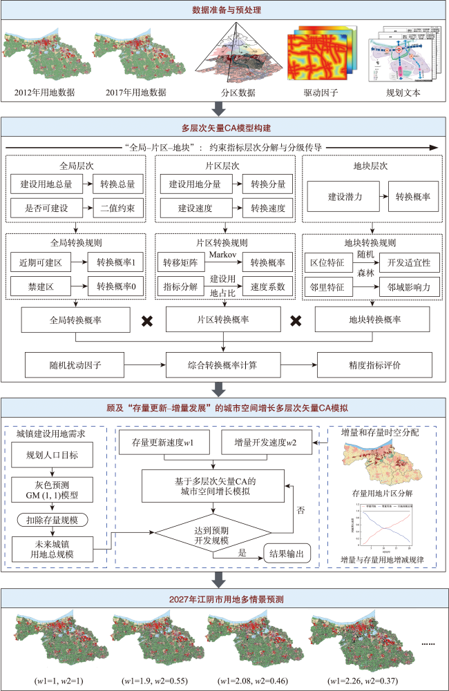
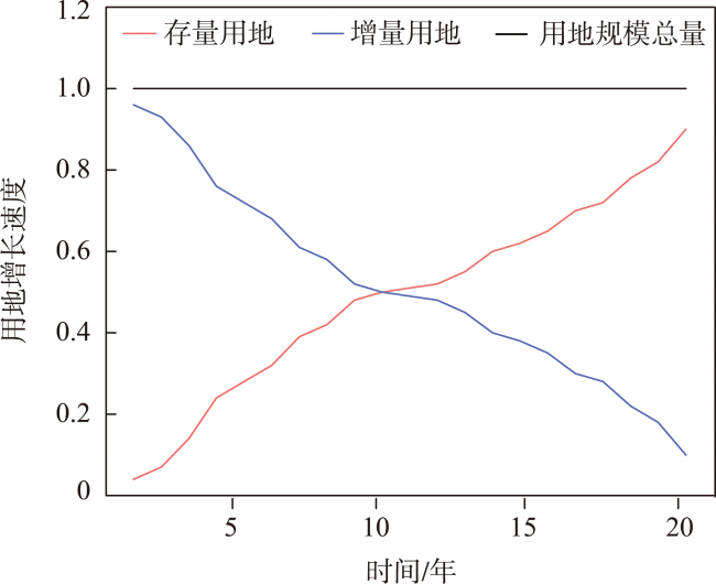
我国大多数城市正处于从增量规划向存量规划转型的过渡阶段,存量规划的实施仍需以增量规划为基础,二者之间相辅相成、协同发展。值此转型阶段,新的国土空间规划体系强调了规划的层级传导,从宏观到微观,渐近式地引导和约束着城市的发展方向。本文依据存量更新与增量发展的时空增减更替变化规律,分别进行参数控制以实现二者指标的调整和面积分配,将其纳入到多层次矢量元胞自动机(Vector Cellular Automata,VCA)模型中,以此实现顾及“存量更新-增量发展”的城市空间增长多层次矢量CA模拟,并将其应用于存量规划背景下的江阴市2027年多情景用地增长预测与分析。研究结论如下: ① 多层次VCA通过不同层次间驱动力自上而下差异性分解与自下而上协同性传递的方式,既完成了上层管控的指标落实,又实现了用地模拟的精细化控制; ② 多层次VCA给予不同片区差异化的速度参数,充分顾及到了驱动因子与用地分布的空间异质性,其整体FoM达到了24.6%,精度相比单层次VCA高2.5%;局部细节特征上,多层次VCA对不同用地类型的错分情况以及对水域等禁建区的侵占情况要比单层次的模拟结果少,且对条状地块的模拟效果更好; ③ 在“底线管控-分层管控-指标管控”层次约束下,随着存量更新速度的提高,不同情景下预测的新增建设用地的扩张情况均保持在规划控制的范围之内,且集中在澄西、澄南和澄东南3个片区,这与规划划定的增长边界和用地布局结构相吻合; ④ 不同情景下存量用地更新方向以工业用地为主导,乡村建设用地次之,情景二中(d)和(e)的模拟结果中,工业更新趋于饱和,整体实现均衡增长,可作为未来江阴市用地格局发展的主要参考。

朱杰 , 朱梦瑶 , 宋书颖 , 丁远 , 陈丽 , 朱学明 , 孙毅中 . 顾及存量更新与增量发展不均速率的城市空间增长模拟研究[J]. 地球信息科学学报, 2024 , 26(8) : 1858 -1879 . DOI: 10.12082/dqxxkx.2024.240135
In China, the majority of cities are currently transitioning from incremental planning to inventory planning. The implementation of inventory planning still relies on incremental planning as its foundation, with the two approaches complementing each other and developing in coordination. During this transition, the new national spatial planning system emphasizes the hierarchical transmission of planning, guiding and constraining urban development progressively from macro to micro levels. This study is based on a multi-level Vector Cellular Automata (VCA) model. We use land use data from Jiangyin City in 2012 as the foundation to simulate and analyze land use changes in 2017, and then verify the accuracy of the VCA model. Subsequently, adhering to the spatiotemporal patterns of stock renewal and incremental development, parameters are adjusted and area allocations are made separately to integrate these two indicators. They are then incorporated into the multi-level VCA model. This approach allows for a multi-level simulation of urban spatial growth, considering both stock renewal and incremental development. Then, this approach is applied to predict and analyze multiple scenarios of land use growth in Jiangyin City in 2027 within the context of stock planning. The conclusions of the study are as follows: ① The multi-level VCA decomposes differential driving forces from top to bottom and transmits them collaboratively from bottom to top, achieving both the implementation of upper-level control indicators and fine-grained control of land use simulation. ② The multi-level VCA assigns differentiated speed parameters to different regions, fully considering the spatial heterogeneity of driving factors and land distribution. The overall Figure of Merit (FoM) reaches 24.6%, which is 2.5% higher than that of the single-level VCA. At the local detail level, the multi-level VCA exhibits fewer misclassifications of different land use types and less encroachment on prohibited areas such as water bodies compared to single-level simulations, with better simulation results for linear land parcels. ③ Under the constraints of "baseline control-layered control-indicator control," with the increase in stock renewal speed, the expansion of newly predicted construction land in different scenarios remains within the range of planned control. The scale of expansion for newly predicted construction land is reduced, and it is concentrated in the West, South, and Southeast of Jiangyin city. This transition aligns with the growth boundaries and land layout structure designated in the master planning outline. In different scenarios, stock land renewal is dominated by industrial land, followed by rural construction land. ④ In scenarios (d) and (e), industrial renewal tends toward saturation, achieving overall balanced growth, serving as a key reference for future land use pattern development in Jiangyin City.
表1 “全局-片区-地块”层次传导内容Tab. 1 "Global-District-Parcel" Hierarchical Transmission |
| 层次 | 管控内容 | 管控形式 |
|---|---|---|
| 全局 | 建设指标总量、是否建设 | 转换总量+二值约束 |
| 片区 | 建设指标分量、建设速度 | 转换分量+转换速度 |
| 地块 | 建设潜力 | 转换概率 |
表2 数据来源与分类Tab. 2 Data sources and classifications |
| 分类 | 数据名称 | 时间/年 | 数据来源 |
|---|---|---|---|
| 用地数据 | 江阴市用地现状数据 | 2007、2012、2017 2012、2017 2015—2020 | 江阴市城乡规划设计院 |
| 江阴市道路现状数据 | |||
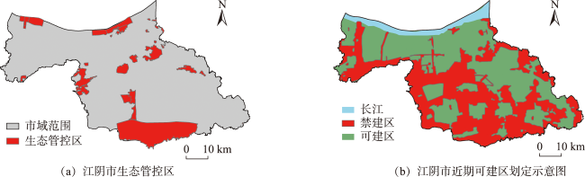
| 江阴市生态红线数据 | |||
| 江阴市待更新地块数据 | 2017 | ||
| 驱动因子 | 自然要素 (DEM高程、坡度) | 2012 | 地理空间数据云[34] (https://www.gscloud.cn/) |
| 交通因素 (距水体的距离、距高速公路距离、距快速路距离、距城市主干道距离、距城市次干道距离) | 2012 | 地理空间数据云[34] (https://www.gscloud.cn/) | |
| 城市格局 (距城市中心距离、距城镇中心距离) | 2012 | 资源环境科学与数据平台[35] (http://www.resdc.Cn) | |
| 社会经济 (夜间灯光) | 2012 | NOAA National Centers for Environmental Information (NCEI) [36] (https://www.ngdc.noaa.gov/eog/viirs/) | |
| 分区数据 | 江阴市建设分区数据 | 2015—2020 2015—2020 2015—2020 2012 | 江阴市城乡规划设计院 |
| 江阴市行政区划与规划分区数据 | |||
| 江阴市城镇增长边界与储备用地边界 | |||
| 《江阴市城市总体规划(2011-2030)》[37] | |||
| 规划文本 | 《江阴市国土空间总体规划(2021-2035)》[33] | 2022 | 江阴市人民政府,江阴市自然资源和规划局 |
| 《江阴市生态红线区域保护规划(征求意见稿)》[38] | 2014 |
表3 2012—2017建设用地的初始年增长速度Tab. 3 The initial annual growth rate of construction land from 2012 to 2017 |
| 精度指标 | 片区 | 市域范围 | ||||
|---|---|---|---|---|---|---|
| 中心 | 澄东 | 澄西 | 澄南 | 澄东南 | ||
| 规划人口/万人 | 40.71 | 24.13 | 28.06 | 18.64 | 13.73 | 125.27 |
| 2012年建设用地/km2 | 127.43 | 75.53 | 87.84 | 58.35 | 42.98 | 392.13 |
| 2017年建设用地指标/km2 | 136.34 | 80.81 | 93.98 | 62.43 | 45.98 | 419.54 |
| 建设用地增速/(km2/年) | 1.782 | 1.056 | 1.228 | 0.816 | 0.600 | 5.482 |
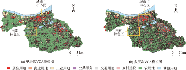
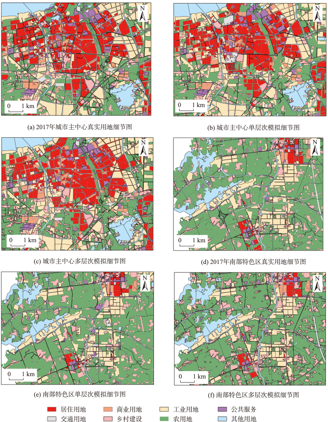
图7 基于多层次VCA和单层次VCA的江阴市2017年用地模拟结果对比Fig. 7 Comparisons of land use simulation results for Jiangyin City in 2017 based on Multilevel-VCA and Single-level VCA |
表4 基于多层次VCA和单层次VCA的江阴市2017年模拟结果精度对比Tab. 4 Comparisons of simulation accuracy for Jiangyin City in 2017 based on Multilevel-VCA and Single-level VCA |
| 精度指标 | 片区 | 市域范围 | ||||
|---|---|---|---|---|---|---|
| 中心 | 澄东 | 澄西 | 澄南 | 澄东南 | ||
| 单层次模拟结果Kappa | 0.829 | 0.813 | 0.862 | 0.837 | 0.797 | 0.831 |
| 多层次模拟结果Kappa | 0.771 | 0.801 | 0.835 | 0.794 | 0.789 | 0.856 |
| 单层次模拟结果FoM | 0.256 | 0.192 | 0.239 | 0.215 | 0.193 | 0.221 |
| 多层次模拟结果FoM | 0.226 | 0.240 | 0.236 | 0.215 | 0.221 | 0.246 |
| 单层次建设用地模拟面积/km2 | 106.390 | 88.100 | 78.620 | 66.240 | 60.760 | 400.110 |
| 多层次建设用地模拟面积/km2 | 110.220 | 91.770 | 81.420 | 69.840 | 57.260 | 410.510 |
| 2017年建设用地面积现状/km2 | 111.160 | 91.350 | 83.340 | 67.970 | 57.860 | 411.680 |
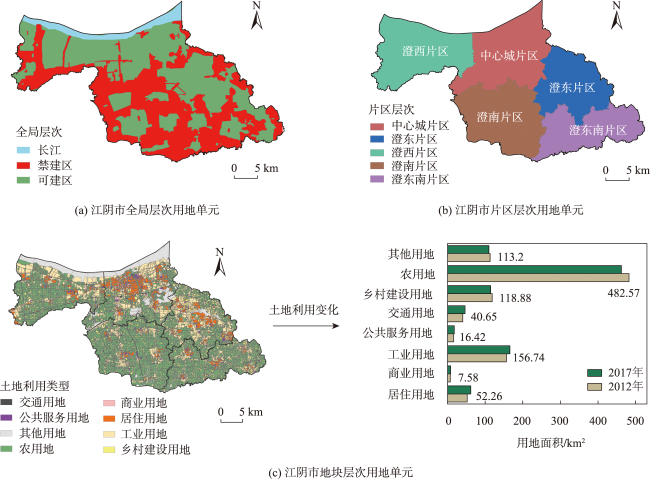
表5 江阴市2017年各片区用地置换结果Tab. 5 Land replacement results for each area in Jiangyin city in 2017 (km2) |
| 片区 | 建设用地 面积 | 待更新用地 面积 | 建设用地 面积更新 |
|---|---|---|---|
| 中心 | 135.09 | 20.82 | 114.27 |
| 澄东 | 80.07 | 9.30 | 70.77 |
| 澄西 | 93.11 | 6.33 | 86.78 |
| 澄南 | 61.85 | 0.00 | 61.85 |
| 澄东南 | 45.56 | 0.00 | 45.56 |
| 市域 | 415.68 | 36.45 | 379.23 |
表6 各片区2017年建设用地面积与2027年预测面积Tab. 6 The area of construction land in 2017 and the area predicted in 2027 in each area (km2) |
| 片区 | 2017年建设 用地面积/km2 | 2027年预测建设 用地面积/km2 | 建设用地增量 速率/(km2/年) |
|---|---|---|---|
| 中心城 | 114.270 | 141.000 | 2.673 |
| 澄东 | 86.780 | 97.190 | 1.041 |
| 澄西 | 70.770 | 83.580 | 1.281 |
| 澄南 | 61.850 | 64.560 | 0.271 |
| 澄东南 | 45.560 | 47.550 | 0.199 |
| 市域 | 379.230 | 433.880 | 5.465 |
表7 2027年各片区初始更新速度与初始新增用地速度Tab. 7 The initial renewal rate and the initial new land use rate of each area in 2027 (km2/年) |
| 片区 | 初始新增用地 速度 | 初始用地更新 速度 |
|---|---|---|
| 中心 | 0.591 | 2.082 |
| 澄西 | 0.111 | 0.930 |
| 澄东 | 0.648 | 0.633 |
| 澄南 | 0.271 | 0.000 |
| 澄东南 | 0.199 | 0.000 |
| 市域 | 1.820 | 3.645 |
表8 2027年2种存量更新-增量发展情景设置Tab. 8 Scenarios of stock renewal and incremental development set for 2027 |
| 情景 | 存量更新情景 | 增量发展情景 | 说明 |
|---|---|---|---|
| 一 | 匀速 (w1=1) | 匀速 (w2=1) | 建设用地增长规模确定的情况下,存量更新与增量扩张速度固定不变 |
| 二 | 加速 (w1>1) | 低速 (w2<1) | 建设用地增长规模确定的情况下,存量更新速度加快,增量扩张速度减缓,实现从“扩增量”到“优存量”的转变 |
表9 不同情景对应的控制参数Tab. 9 Control parameters for different scenarios |
| 情景 | 参数 | 2018年 | 2019年 | 2020年 | 2021年 | 2022年 | 2023年 | 2024年 | 2025年 | 2026年 | 2027年 |
|---|---|---|---|---|---|---|---|---|---|---|---|
| 一 | w1/w2 | 1/1 | 1/1 | 1/1 | 1/1 | 1/1 | 1/1 | 1/1 | 1/1 | 1/1 | 1/1 |
| 二(a) | w1/w2 | 1/1 | 1.1/0.95 | 1.2/0.9 | 1.3/0.85 | 1.4/0.8 | 1.5/0.75 | 1.6/0.7 | 1.7/0.65 | 1.8/0.6 | 1.9/0.55 |
| 二(b) | w1/w2 | 1/1 | 1.12/0.94 | 1.24/0.88 | 1.36/0.82 | 1.48/0.76 | 1.6/0.7 | 1.72/0.64 | 1.84/0.58 | 1.96/0.52 | 2.08/0.46 |
| 二(c) | w1/w2 | 1/1 | 1.14/0.93 | 1.28/0.86 | 1.42/0.79 | 1.56/0.72 | 1.7/0.65 | 1.84/0.58 | 1.98/0.51 | 2.12/0.44 | 2.26/0.37 |
| 二(d) | w1/w2 | 1/1 | 1.16/0.92 | 1.32/0.84 | 1.48/0.76 | 1.64/0.68 | 1.8/0.6 | 1.96/0.52 | 2.12/0.44 | 2.28/0.36 | 2.44/0.28 |
| 二(e) | w1/w2 | 1/1 | 1.18/0.91 | 1.36/0.82 | 1.54/0.73 | 1.72/0.64 | 1.9/0.55 | 2.08/0.46 | 2.26/0.37 | 2.44/0.28 | 2.62/0.19 |
表10 2027年江阴市存量用地变化Tab. 10 Changes in inventory land use in Jiangyin city in 2027 (km2,%) |
| 用地类型 | 2017年 | 情景一 | 情景二(a) | 情景二(b) | 情景二(c) | 情景二(d) | 情景二(e) | |||||||||||||
|---|---|---|---|---|---|---|---|---|---|---|---|---|---|---|---|---|---|---|---|---|
| 转移量 | 占比 | 转移量 | 占比 | 转移量 | 占比 | 转移量 | 占比 | 转移量 | 占比 | 转移量 | 占比 | 转移量 | 占比 | |||||||
| 居住用地 | 3.17 | 8.69 | 0.01 | 0.04 | 0.29 | 0.80 | 0.62 | 1.70 | 0.64 | 1.76 | 1.09 | 3.00 | 1.33 | 3.65 | ||||||
| 商业用地 | 0.07 | 0.19 | 0.00 | 0.00 | 0.00 | 0.00 | 0.00 | 0.00 | 0.00 | 0.00 | 0.22 | 0.60 | 0.53 | 1.45 | ||||||
| 工业用地 | 31.53 | 86.52 | 2.37 | 6.49 | 8.32 | 22.82 | 11.22 | 30.78 | 15.39 | 42.22 | 21.43 | 58.79 | 22.40 | 61.45 | ||||||
| 公共服务 | 0.26 | 0.71 | 0.001 | 0.004 | 0.19 | 0.52 | 0.29 | 0.80 | 0.18 | 0.49 | 0.07 | 0.19 | 0.70 | 1.92 | ||||||
| 交通用地 | 0.81 | 2.22 | 0.02 | 0.04 | 0.66 | 1.81 | 0.66 | 1.81 | 0.69 | 1.90 | 0.14 | 0.38 | 1.86 | 5.10 | ||||||
| 乡村建设 | 0.61 | 1.67 | 0.44 | 1.20 | 4.09 | 11.23 | 4.33 | 11.88 | 5.33 | 14.62 | 4.40 | 12.07 | 4.48 | 12.30 | ||||||
| 待更新 | - | - | 33.61 | 92.22 | 22.90 | 62.82 | 19.33 | 53.03 | 14.22 | 39.01 | 9.10 | 24.97 | 5.15 | 14.13 | ||||||
| [1] |
陆大道, 陈明星. 关于“国家新型城镇化规划(2014—2020)” 编制大背景的几点认识[J]. 地理学报, 2015, 70(2):179-185.
[
|
| [2] |
邹兵. 由“增量扩张”转向“存量优化”——深圳市城市总体规划转型的动因与路径[J]. 规划师, 2013, 29(5):5-10.
[
|
| [3] |
赵冠宁, 司马晓, 黄卫东, 等. 面向存量的城市规划体系改良:深圳的经验[J]. 城市规划学刊, 2019,(4):87-94.
[
|
| [4] |
邹兵. 增量规划向存量规划转型:理论解析与实践应对[J]. 城市规划学刊, 2015(5):12-19.
[
|
| [5] |
邹兵. 存量发展模式的实践、成效与挑战——深圳城市更新实施的评估及延伸思考[J]. 城市规划, 2017, 41(1):89-94.
[
|
| [6] |
李志强, 钱雨果, 周伟奇, 等. 从“增量扩张”到“存量优化”:深圳市景观格局内部动态与优化[J]. 生态学报, 2021, 41(5):1738-1746.
[
|
| [7] |
林坚, 叶子君, 杨红. 存量规划时代城镇低效用地再开发的思考[J]. 中国土地科学, 2019, 33(9):1-8.
[
|
| [8] |
吴志强, 伍江, 张佳丽, 等. “城镇老旧小区更新改造的实施机制”学术笔谈[J]. 城市规划学刊, 2021(3):1-10.
[
|
| [9] |
李震, 赵万民. 国土空间规划语境下的城市更新变革与适应性调整[J]. 城市问题, 2021(5):52-60.
[
|
| [10] |
冯长春, 程龙. 老城区存量土地集约利用潜力评价——以北京市东城区为例[J]. 城市发展研究, 2010, 17(7):86-92.
[
|
| [11] |
刘晶, 金晓斌, 张志飞, 等. 低效(闲置)铁路存量用地综合开发利用策略分析:方法与实证[J]. 自然资源学报, 2017, 32(3):377-390.
[
|
| [12] |
|
| [13] |
莫正玺, 叶强, 赵垚. 我国存量建设空间利用的政策、理论与实践演进脉络[J]. 经济地理, 2022, 42(6):156-167.
[
|
| [14] |
黄梦石. 存量规划视角下哈尔滨城市建设用地调控研究[D]. 哈尔滨: 哈尔滨工业大学, 2019.
[
|
| [15] |
黎夏, 刘小平. “三规合一”服务的空间信息技术:地理模拟与优化[J]. 遥感学报, 2016, 20(5):1308-1318.
[
|
| [16] |
杨俊, 解鹏, 席建超, 等. 基于元胞自动机模型的土地利用变化模拟——以大连经济技术开发区为例[J]. 地理学报, 2015, 70(3):461-475.
[
|
| [17] |
戴云哲, 杨建新, 龚健, 等. AutoPaCA:耦合过程-模式的城镇空间增长模拟模型[J]. 地球信息科学学报, 2022, 24(1):87-99.
[
|
| [18] |
蔡玉梅, 刘彦随, 宇振荣, 等. 土地利用变化空间模拟的进展——CLUE-S模型及其应用[J]. 地理科学进展, 2004, 23(4):63-71,115.
[
|
| [19] |
刘小平, 黎夏, 陈逸敏, 等. 基于多智能体的居住区位空间选择模型[J]. 地理学报, 2010, 65(6):695-707.
[
|
| [20] |
李岩, 林安琪, 吴浩, 等. 顾及空间尺度效应的城市土地利用变化精细化模拟[J]. 地理学报, 2022, 77(11):2738-2756.
[
|
| [21] |
方创琳, 李广东, 张蔷. 中国城市建设用地的动态变化态势与调控[J]. 自然资源学报, 2017, 32(3):363-376.
[
|
| [22] |
梁嘉洋. 存量规划视角下礼泉县中心城区城镇开发边界划定研究[D]. 西安: 长安大学, 2022.
[
|
| [23] |
周垠, 龙瀛. 存量、增量之辩下的城镇用地开发与模拟研究——以成都市为例[J]. 地理与地理信息科学, 2016, 32(5):45-51.
[
|
| [24] |
郭嵘, 黄梦石. 存量规划视角下城市开发边界的划定方法[J]. 规划师, 2016, 32(10):57-61.
[
|
| [25] |
|
| [26] |
|
| [27] |
孙毅中, 杨静, 宋书颖, 等. 多层次矢量元胞自动机建模及土地利用变化模拟[J]. 地理学报, 2020, 75(10):2164-2179.
[
|
| [28] |
|
| [29] |
|
| [30] |
|
| [31] |
|
| [32] |
|
| [33] |
江阴市自然资源和规划局. 江阴市国土空间总体规划(2021-2035)[EB/OL].(2022)[2022-12-17].
[Jiangyin municipal bureau of natural resources and planning. Jiangyin city land and space master plan(2021-2035)[EB/OL].(2022)[2022-12-17]. http://zrzy.jiangsu.gov.cn/wxjy/gtzx/tz/qtgg/202212/t20221217_1351085.htm.]
|
| [34] |
中国科学院计算机网络信息中心. 地理空间数据云[DB/OL].
[Computer Network Information Center of Chinese Academy of Sciences. Geospatial Data Cloud[DB/OL]. https://www.gscloud.cn/.]
|
| [35] |
中国科学院资源环境科学与数据中心. 资源环境科学与数据平台[DB/OL].
[ Resource and Environmental Science Data Center. Resource and Environmental Science Data Platform[DB/OL]. http://www.resdc.cn/.]
|
| [36] |
NOAA National Centers for Environmental Information (NCEI)[DB/OL]. https://www.ngdc.noaa.gov/eog/viirs/.
|
| [37] |
江苏省人民政府. 江阴市城市总体规划(2011-2030)[EB/OL].(2012)[2012-02-15].
[Jiangsu provincial people's government. Jiangyin city master plan (2011-2030)[EB/OL].(2012)[2012-02-15]. https://max.book118.com/html/2019/0510/8032011133002022.shtm.]
|
| [38] |
江阴市城乡规划设计院. 江阴市生态红线区域保护规划(征求意见稿)[EB/OL].(2011) [2014-10].
[Jiangyin urban and rural planning and design institute. Jiangyin ecological redline area protection plan (draft for solicitation of comments)[EB/OL].(2011) [2014-10]. https://max.book118.com/html/2016/0517/43137041.shtm.]
|
| [39] |
刘鹏华, 刘小平, 姚尧, 等. 耦合约束动态地块分裂和矢量元胞自动机的城市扩张模拟[J]. 地理与地理信息科学, 2018, 34(4):74-82.
[
|
| [40] |
|
| [41] |
钟珊, 赵小敏, 郭熙, 等. 基于空间适宜性评价和人口承载力的贵溪市中心城区城市开发边界的划定[J]. 自然资源学报, 2018, 33(5):801-812.
[
|
| [42] |
中华人民共和国住房和城乡建设部, 中华人民共和国国家质量监督检验检疫总局. 城市用地分类与规划建设用地标准[EB/OL].(2011)[2011-01-01]. https://www.planning.org.cn/law/uploads/2013/1383993139.pdf.
[Ministry of housing and urban-rural development of the people's republic of China, general administration of quality supervision, inspection and quarantine of the people's republic of China. Urban land classification and planning and construction land standards[EB/OL].(2011)[2011-01-01].]
|
/
| 〈 |
|
〉 |


