
基于云原生的地理空间知识库管理关键技术与服务方法研究
|
仲腾(1988— ),男,江苏盐城人,副教授,硕士生导师,主要研究方向为地理知识图谱与知识服务。E-mail: tzhong27@njnu.edu.cn |
Editor: 蒋树芳
收稿日期: 2024-04-02
修回日期: 2024-08-12
网络出版日期: 2024-09-10
基金资助
国家重点研发计划项目(2021YFB3900903)
Critical Technologies and Service Approaches for Cloud-Native Geospatial Knowledge Base Management
Received date: 2024-04-02
Revised date: 2024-08-12
Online published: 2024-09-10
Supported by
National Key Research and Development Program of China(2021YFB3900903)
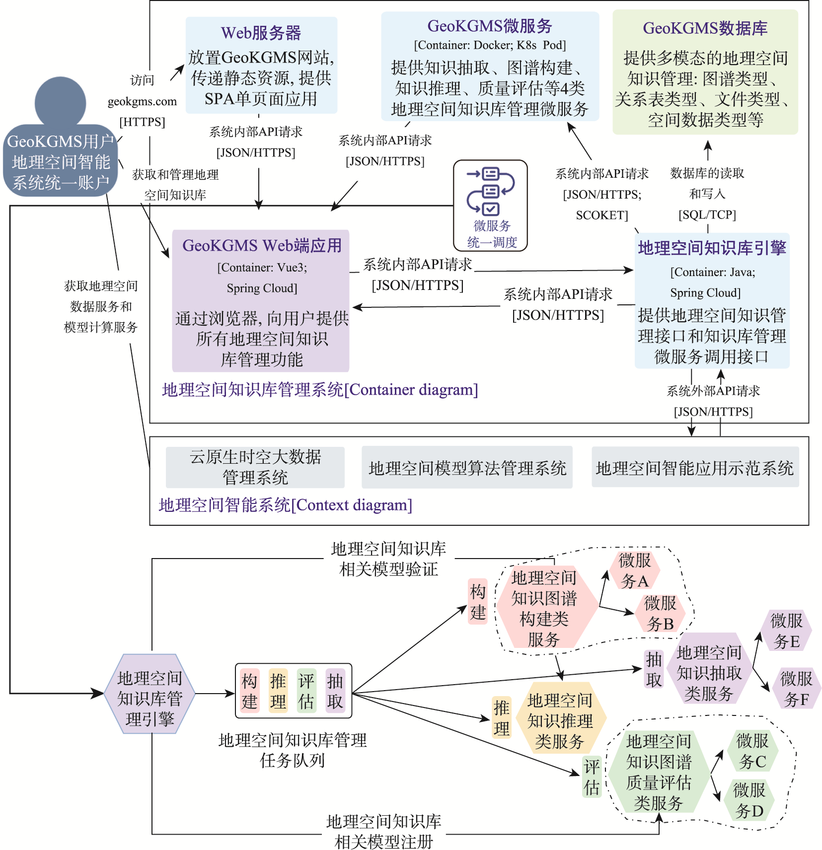
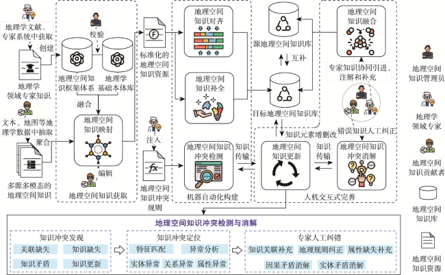
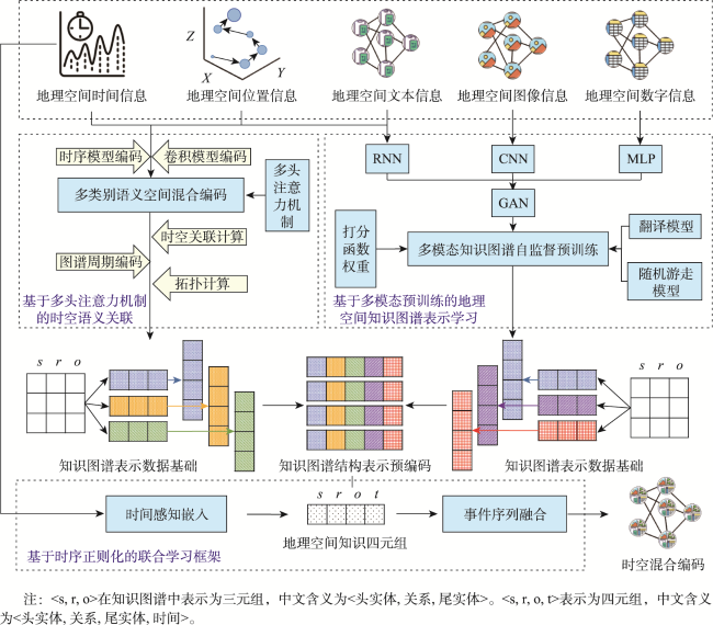
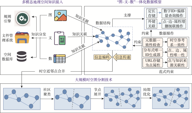
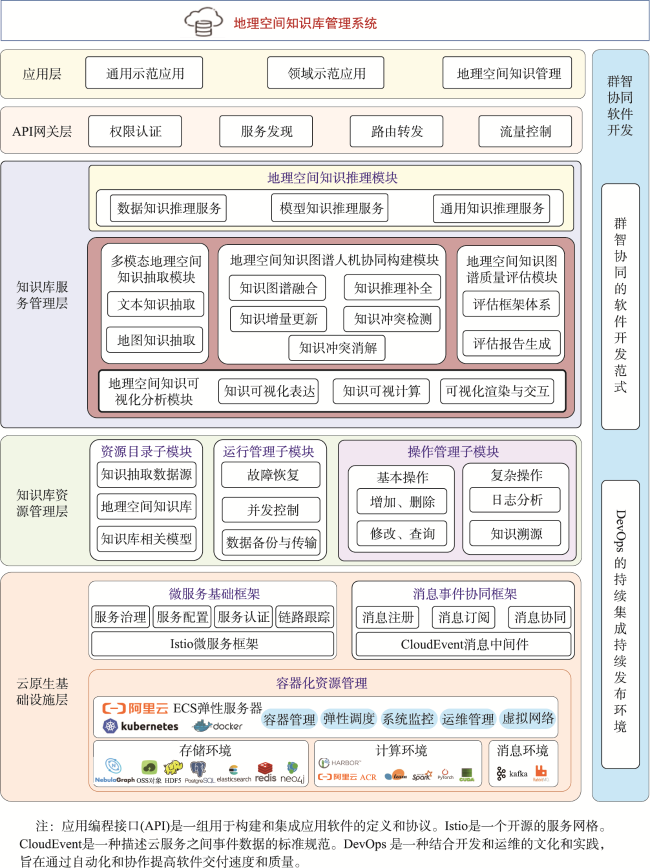
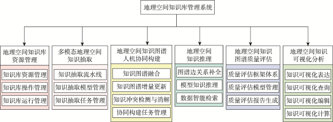
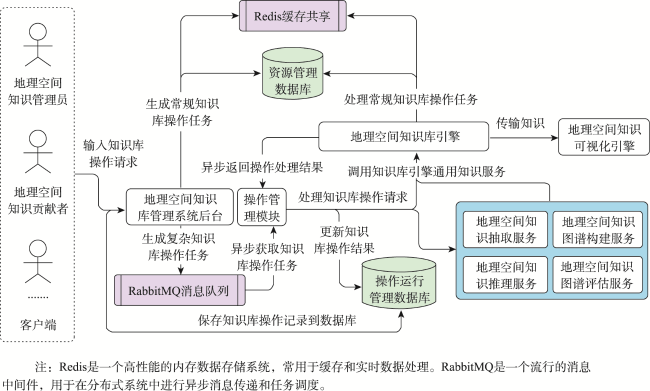
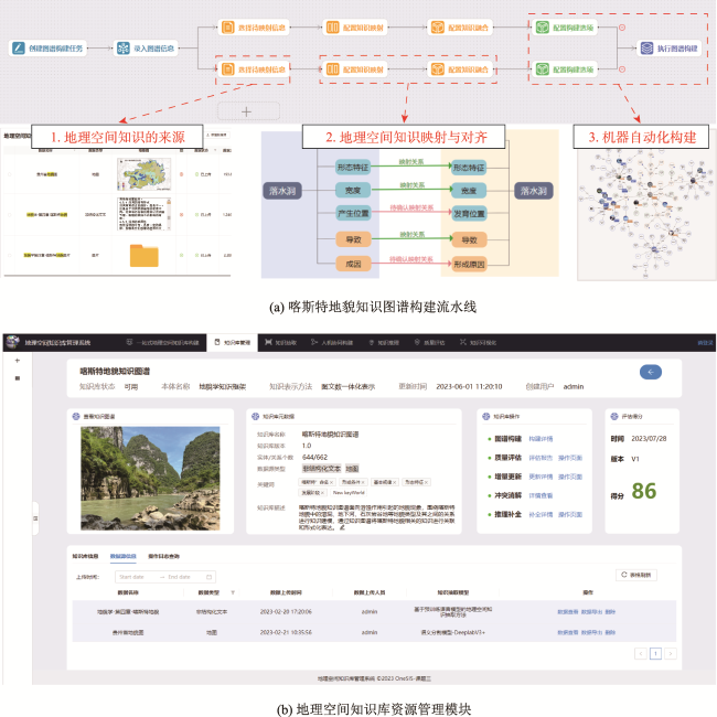
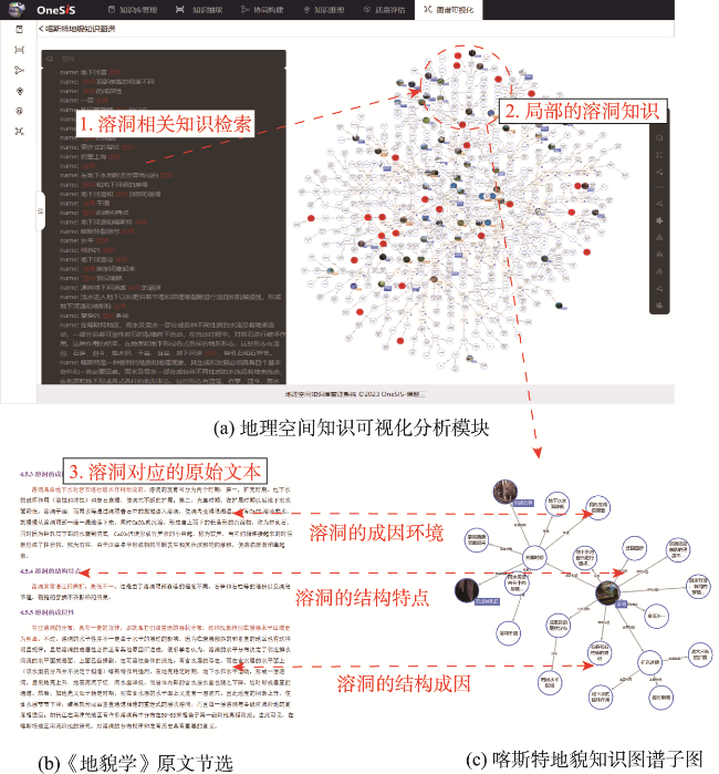
地理空间知识的本质在于揭示地理事物和现象的时空分布、时空变化过程及其相互作用规律。地理空间知识库管理系统(GeoKGMS)以“图-文-数”一体化的地理空间知识库引擎为核心,致力于支撑地理空间知识资源的高效汇聚、地理空间知识图谱的自动构建和一站式地理空间知识工程建设,旨在形成新一代地理信息系统(GIS)的重要基础平台。本文重点阐述了基于云原生的地理空间知识库管理关键技术,包括云原生的地理空间知识库微服务统一调度技术、人机协同的地理空间知识图谱构建技术、地理空间知识图谱时空混合编码技术、以及多模态地理空间知识存储技术。在此基础上,设计了GeoKGMS的服务框架,实现了地理空间知识库管理、多模态地理空间知识抽取、地理空间知识图谱人机协同构建、地理空间知识推理、地理空间知识图谱质量评估和地理空间知识可视化六大管理服务功能。以喀斯特地貌知识图谱为例,充分发挥机器挖掘和专家知识的优势,实现了可持续的地理空间知识图谱工程化协同共建。
仲腾 , 张雪英 , 许沛 , 曹敏 , 陈碧宇 , 刘启亮 , 王曙 , 杨宜舟 . 基于云原生的地理空间知识库管理关键技术与服务方法研究[J]. 地球信息科学学报, 2024 , 26(9) : 2013 -2025 . DOI: 10.12082/dqxxkx.2024.240184
The essence of geospatial knowledge lies in unveiling the spatiotemporal distribution, dynamics of change, and interaction patterns of geographical entities and phenomena. However, existing knowledge base management platforms often overlook the specific needs of geospatial knowledge representation and lack the capability to handle the unique attributes of geospatial data, making it challenging to meet the requirements for constructing and applying geospatial knowledge graphs. The Geospatial Knowledge Base Management System (GeoKGMS) is designed on the basis of an integrated geospatial knowledge base engine that efficiently aggregates geospatial knowledge resources across various modalities—'Image-Text-Number'—automates the construction of geospatial knowledge graphs, and facilitates a one-stop geospatial knowledge engineering process. This paper elucidates four key technologies for managing geospatial knowledge bases. First, the cloud-native geospatial knowledge base microservice unified scheduling technology decomposes the large geospatial knowledge base management system into fine-grained, independently operable, and deployable microservices. By comprehensively managing the lifecycle of the geospatial knowledge base, service classification and orchestration methods are determined to achieve unified scheduling of these microservices. Second, a human-computer collaborative geospatial knowledge graph construction method is proposed, supporting the sustainable, collaborative construction of geospatial knowledge graph engineering. Third, the spatiotemporal hybrid encoding technology of the geospatial knowledge graph achieves unified representation of geospatial knowledge by integrating multimodal geospatial data and spatiotemporal information. Fourth, a multimodal geospatial knowledge integrated storage and large-scale spatiotemporal graph partitioning technology is proposed to address the challenges of efficiently managing complex structured geospatial knowledge and retrieving large-scale spatiotemporal knowledge tuples. Based on these key technologies, an application service framework for GeoKGMS has been designed, featuring six functional modules: geospatial knowledge base management, multimodal geospatial knowledge extraction, human-computer collaborative construction of geospatial knowledge graphs, geospatial knowledge reasoning, geospatial knowledge graph quality assessment, and geospatial knowledge visualization. To demonstrate GeoKGMS's capabilities, the Karst landform knowledge graph is used as a case study. The Karst landform knowledge graph is an integrated 'Image-Text-Number' geospatial knowledge graph, constructed based on geospatial knowledge extracted from the texts, schematic diagrams, and related maps in geomorphology textbooks. Through a collaborative pipeline, geomorphology experts and computers jointly perform tasks such as mapping, alignment, supplementation, and conflict resolution of geospatial knowledge. This collaboration ultimately leads to the automated construction of the Karst landform knowledge graph by GeoKGMS. The resulting graph is highly consistent with expert knowledge models, ensuring the interpretability of knowledge-driven geocomputation and reasoning in practical applications.
| [1] |
|
| [2] |
|
| [3] |
|
| [4] |
李德仁. 论时空大数据的智能处理与服务[J]. 地球信息科学学报, 2019, 21(12):1825-1831.
[
|
| [5] |
陆锋, 诸云强, 张雪英. 时空知识图谱研究进展与展望[J]. 地球信息科学学报, 2023, 25(6):1091-1105.
[
|
| [6] |
张洪岩, 周成虎, 闾国年, 等. 试论地学信息图谱思想的内涵与传承[J]. 地球信息科学学报, 2020, 22(4):653-661.
[
|
| [7] |
诸云强, 孙凯, 胡修棉, 等. 大规模地球科学知识图谱构建与共享应用框架研究与实践[J]. 地球信息科学学报, 2023, 25(6):1215-1227.
[
|
| [8] |
黄恒琪, 于娟, 廖晓, 等. 知识图谱研究综述[J]. 计算机系统应用, 2019, 28(6):1-12.
[
|
| [9] |
|
| [10] |
|
| [11] |
|
| [12] |
陶坤旺, 赵阳阳, 朱鹏, 等. 面向一体化综合减灾的知识图谱构建方法[J]. 武汉大学学报(信息科学版), 2020, 45(8):1296-1302.
[
|
| [13] |
杜志强, 李钰, 张叶廷, 等. 自然灾害应急知识图谱构建方法研究[J]. 武汉大学学报(信息科学版), 2020, 45(9):1344-1355.
[
|
| [14] |
刘俊楠, 刘海砚, 陈晓慧, 等. 面向多源地理空间数据的知识图谱构建[J]. 地球信息科学学报, 2022, 22(7):1476-1486.
[
|
| [15] |
蒋秉川, 万刚, 许剑, 等. 多源异构数据的大规模地理知识图谱构建[J]. 测绘学报, 2018, 47(8):1051-1061.
[
|
| [16] |
林珲, 游兰, 胡传博, 等. 时空大数据时代的地理知识工程展望[J]. 武汉大学学报(信息科学版), 2018, 43(12):2205-2211.
[
|
| [17] |
王传庆, 李阳阳, 费超群, 等. 知识图谱平台综述[J]. 计算机应用研究, 2022, 39(11):3201-3210.
[
|
| [18] |
|
| [19] |
|
| [20] |
|
| [21] |
张斌, 魏扣, 郝琦. 国内外知识库研究现状述评与比较[J]. 图书情报知识, 2016, 33(3):15-25.
[
|
| [22] |
陆锋, 余丽, 仇培元. 论地理知识图谱[J]. 地球信息科学学报, 2017, 19(6):723-734.
[
|
| [23] |
张雪英, 张春菊, 吴明光, 等. 顾及时空特征的地理知识图谱构建方法[J]. 中国科学:信息科学, 2020, 50(7):1019-1032.
[
|
| [24] |
化立志. 基于知识图谱的领域知识库管理系统的设计与实现[D]. 北京: 北京邮电大学, 2018.
[
|
| [25] |
石顺中, 闾海荣, 董少春, 等. 地球科学知识体系编辑平台[J]. 高校地质学报, 2020, 26(4):384-394.
[
|
| [26] |
王鑫, 邹磊, 王朝坤, 等. 知识图谱数据管理研究综述[J]. 软件学报, 2019, 30(7):2139-2174.
[
|
| [27] |
|
| [28] |
南京大学地理系地貌教研组. 地貌学[M]. 北京: 人民教育出版社, 1961.
[Department of Geomorphology, Nanjing University. Geomorphology[M]. Beijing: People's Education Press, 1961.]
|
/
| 〈 |
|
〉 |
