
XGBoost和DSCGAN模型协同的SMAP土壤水分降尺度方法
|
王思超(1999— ),男,山东枣庄人,硕士生,主要从事水文遥感方面的研究。E-mail: wsc2585690362@163.com |
Editor: 蒋树芳
收稿日期: 2024-03-20
修回日期: 2024-07-03
网络出版日期: 2024-09-10
基金资助
国家重点研发计划子课题(2019YFE0126700)
山东省自然科学基金项目(ZR2022MD018)
Downscaling SMAP Soil Moisture Using a Combination of XGBoost and DSCGAN Algorithms
Received date: 2024-03-20
Revised date: 2024-07-03
Online published: 2024-09-10
Supported by
National Key Research and Development Program of China(2019YFE0126700)
National Key Research and Development Program of Shandong Province, China(ZR2022MD018)
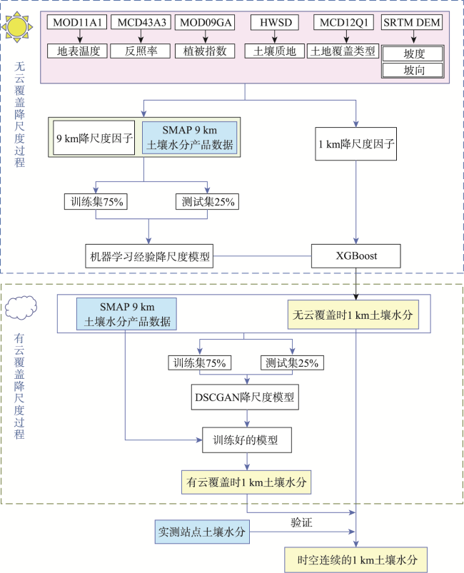
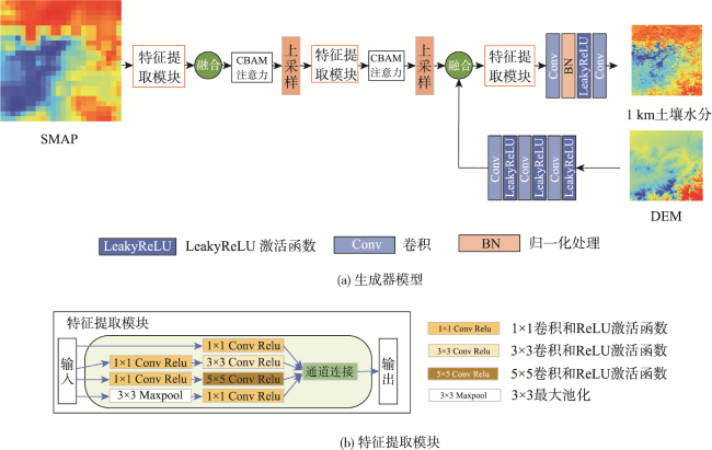
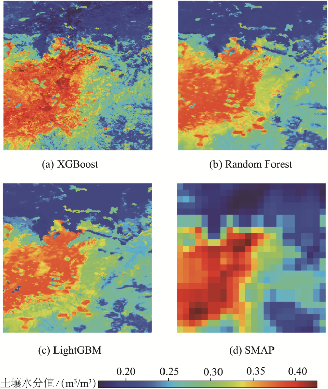
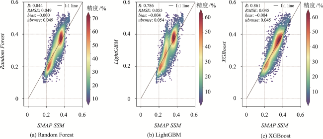
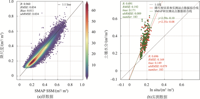
卫星微波遥感的SMAP土壤水分产品可以用于大陆和全球尺度,但因为空间分辨率低,难以满足中小尺度的应用。经验性降尺度方法是空间降尺度常用方法,但因为需要依赖于光学遥感获取降尺度因子,所以易受云雾影响导致无法获得时间连续的高空间分辨率土壤水分。为了解决这个问题,我们结合机器学习和深度学习方法进行了降尺度研究。首先,获取地表温度、植被指数、反照率、土地覆盖、地形数据、土壤质地等降尺度因子。然后,利用机器学习模型(Random Forest、LightGBM、XGBoost)建立SMAP土壤水分产品数据与降尺度因子的经验降尺度模型。选择其中精度较好的XGBoost模型将SMAP-L4土壤水分产品的空间分辨率由9 km降尺度至1 km。最后,基于9 km和1 km土壤水分数据对训练DSCGAN超分辨率模型,并利用该模型获取研究区域时空连续的土壤水分数据。结果表明,降尺度得到的土壤水分与SMAP 原数据之间的相关性系数R为0.96,均方根误差RMSE为0.034 m3/m3,偏置bias为0.011 m3/m3,无偏均方根误差ubRMSE为0.034 m3/m3。与实测站点之间的相关性系数R为0.696,均方根误差RMSE为0.192 m3/m3,偏置bias为-0.171 m3/m3,无偏均方根误差ubRMSE为0.089 m3/m3。本文方法为生产时空连续的更高空间分辨率的地表土壤水分提供了一个框架,可以满足区域水分调查和农业干旱监测等小尺度应用需求。

王思超 , 蔡玉林 , 朱子正 , 黄修东 , 赵相伟 . XGBoost和DSCGAN模型协同的SMAP土壤水分降尺度方法[J]. 地球信息科学学报, 2024 , 26(9) : 2213 -2225 . DOI: 10.12082/dqxxkx.2024.240152
Due to the coupling effects of climatic conditions, surface and subsurface conditions, and human activities, soil moisture is highly heterogeneous on spatial and temporal scales. The SMAP soil moisture products from satellite microwave remote sensing can be used from continental to global scales, but they are not suitable for small- and medium-scale applications due to low spatial resolution. To improve the spatial resolution of soil moisture products, various downscaling methods have been developed, with the empirical downscaling method being widely used due to its relatively simple calculation. These models require downscaling factors, which are mostly obtained based on optical remote sensing and are susceptible to cloud influence. Therefore, it is impossible to obtain high spatial resolution soil moisture continuously over time using this model for downscaling. To solve this problem, we proposed a downscaling framework based on multiple data sources using machine learning and deep learning methods. The main idea is to use traditional machine learning methods in the absence of clouds and super-resolution methods to downscale soil moisture in the presence of clouds. The combination of these two methods yields time-continuous, high-resolution soil moisture. First, multi-source data were used to obtain fifteen downscaling factors, including surface temperature, normalized vegetation index, albedo, elevation, slope, slope direction, soil cover type, soil texture, etc. Then, three machine learning models (Random Forest, LightGBM, and XGBoost) were used to establish empirical downscaling models of SMAP soil moisture product data with downscaling factors. The best performing XGBoost model was chosen to downscale the spatial resolution of SMAP soil moisture products from 9 km to 1 km. Finally, the DSCGAN super-resolution model was trained based on 9 km and 1 km soil moisture data pairs. The trained models were used to obtain spatio-temporally continuous soil moisture data for the study area. The results show that, by comparing the downscaled soil moisture and original SMAP data, the R is 0.96, the RMSE is 0.034 m3/m3, the bias is 0.011 m3/m3, and the ubRMSE is 0.034 m3/m3. The comparison between the downscaled soil moisture and the measured data shows that the R is 0.696, the RMSE is 0.192 m3/m, the bias is -0.171 m3/m3, and the ubRMSE is 0.089 m3/m3. The downscaling method proposed in this study provides a framework for generating higher resolution spatio-temporally continuous surface soil moisture that can meet the needs of small-scale applications such as regional moisture surveys and agricultural drought monitoring.
表1 研究数据Tab. 1 Research data |
| 类型 | 产品 | 变量 | 空间分辨率 | 时间分辨率 |
|---|---|---|---|---|
| 遥感数据 | MCD43A3 | 反照率 | 500 m | 16-day |
| MOD09GA | 地表反射率 | 500 m | daily | |
| MCD12Q1 | 土地覆盖类型 | 500 m | yearly | |
| MOD11A1 | 地表温度 | 1 km | daily | |
| 其他数据 | HWSD | 土壤质地 | 1 km | — |
| GMTED2010 | 高程 | 7.5″ | — | |
| 土壤水分数据 | SMAP L4 | 土壤水分 | 9 km | 3-hour |
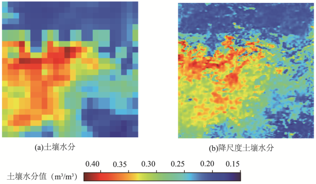
图9 降尺度土壤水分与SMAP 原数据及实测数据的比较Fig. 9 Comparison of downscaled soil moisture with SMAP L4 soil moisture and in situ measured data |
表2 降尺度结果比较Tab. 2 Comparison of downscaled soil moisture results |
| 指标 | R | RMSE/(m3/m3) | Bias/(m3/m3) | ubRMSE/(m3/m3) |
|---|---|---|---|---|
| 降尺度结果与SMAP 原数据对比 | 0.960 | 0.034 | 0.011 | 0.034 |
| 降尺度结果与实测数据对比 | 0.696 | 0.169 | 0.149 | 0.079 |
| SMAP 原数据与实测数据对比 | 0.691 | 0.192 | 0.171 | 0.089 |
| [1] |
|
| [2] |
|
| [3] |
|
| [4] |
|
| [5] |
|
| [6] |
|
| [7] |
|
| [8] |
|
| [9] |
|
| [10] |
|
| [11] |
|
| [12] |
|
| [13] |
|
| [14] |
|
| [15] |
|
| [16] |
|
| [17] |
|
| [18] |
|
| [19] |
|
| [20] |
|
| [21] |
|
| [22] |
赵伟, 文凤平, 蔡俊飞. 被动微波土壤水分遥感产品空间降尺度研究:方法、进展及挑战[J]. 遥感学报, 2022, 26(9):1699-1722.
[
|
| [23] |
|
| [24] |
|
| [25] |
|
| [26] |
|
| [27] |
|
| [28] |
杜晓婉, 陈曦, 郑宏伟, 等. 一种降水降尺度模型:地形约束下的条件生成对抗网络[J]. 地球信息科学学报, 2023, 25(8):1586-1600.
[
|
| [29] |
|
| [30] |
|
| [31] |
|
| [32] |
|
| [33] |
|
| [34] |
|
| [35] |
|
| [36] |
|
| [37] |
|
| [38] |
|
| [39] |
|
| [40] |
|
| [41] |
|
| [42] |
|
| [43] |
|
| [44] |
|
| [45] |
|
| [46] |
|
| [47] |
白瑜, 孟治国, 赵凯. 像元尺度土壤水分监测网络及其对L波段土壤水分产品的初步验证结果[J]. 遥感技术与应用, 2018, 33(1):78-87.
[
|
| [48] |
孟越, 王大刚, 林泳恩. SMOS和SMAP卫星土壤水分产品的对比评价与差异分析[J]. 中山大学学报(自然科学版)(中英文), 2022, 61(5):9-21.
[
|
| [49] |
|
| [50] |
文凤平, 赵伟, 胡路. 耦合MODIS数据的SMAP被动微波土壤水分空间降尺度研究—以闪电河流域为例[J]. 遥感学报, 2021, 25(4):962-973.
[
|
| [51] |
|
| [52] |
|
| [53] |
|
/
| 〈 |
|
〉 |