
顾及形变信息的青藏铁路工程走廊融沉风险评估
|
张正加(1989— ),男,湖北黄冈人,博士,副教授,研究方向为InSAR及其地质灾害、冻土监测应用。E-mail: zhangzj@cug.edu.cn |
Copy editor: 蒋树芳
收稿日期: 2024-07-09
修回日期: 2024-09-11
网络出版日期: 2024-11-07
基金资助
国家自然科学基金项目(41801348)
Risk Assessment of Permafrost Thawing along Qinghai-Tibet Engineering Corridor Integration Ground Deformation
Received date: 2024-07-09
Revised date: 2024-09-11
Online published: 2024-11-07
Supported by
National Natural Science Foundation of China(41801348)
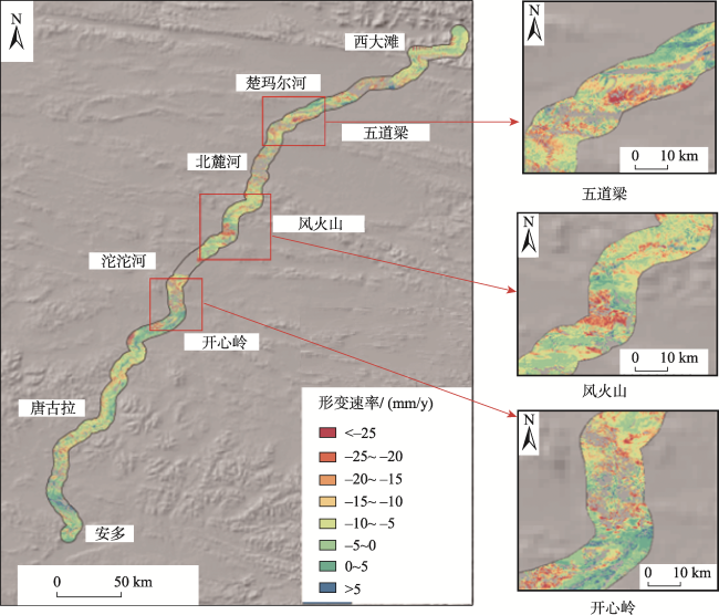
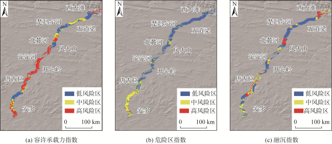
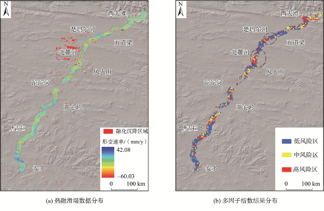
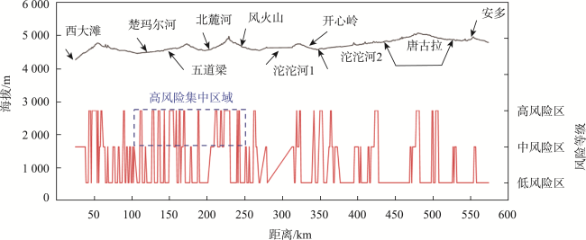
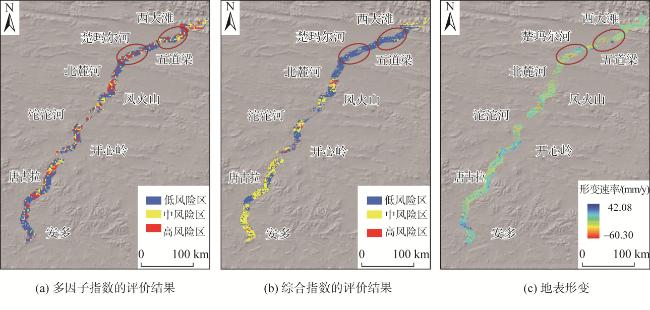
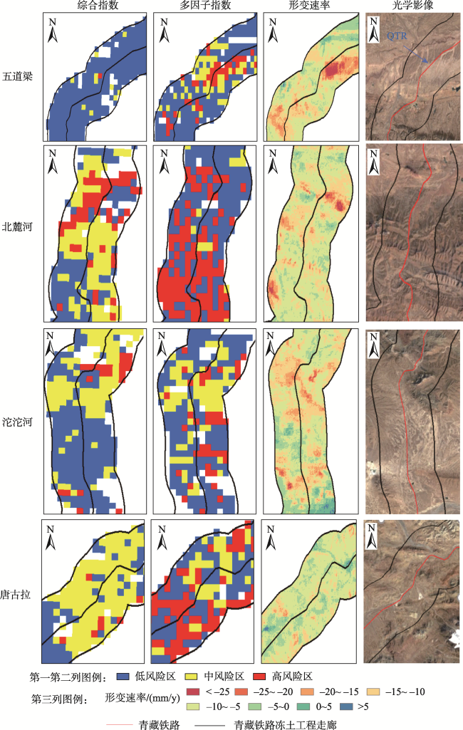
在全球气候变暖和人类活动的共同作用下,青藏铁路工程走廊内的多年冻土发生了严重退化,对人类安全、生态环境和多年冻土工程设施的安全构成了威胁。因此,对青藏铁路工程走廊沿线多年冻土融沉风险进行评估是当务之急。由于现有的冻土融沉风险评估指数大多是静态的,未考虑地表冻融循环过程中的动态性变化,为了准确评估青藏铁路工程走廊的多年冻土融沉风险,本文提出了一种基于层次分析法(Analytic Hierarchy Process, AHP)的多因子指数对青藏铁工程走廊沿线多年冻土融沉危险性进行评估。该指数融合了地面动态形变信息和静态地质灾害评估指数(容许承载力指数、危险区指数和融沉指数),地表形变速率通过小基线干涉测量技术(Small Baseline Subset Interferometric SAR, SBAS-InSAR)获取。实验结果表明,研究区的形变速率范围在-60~43 mm/y,均值为~7 mm/y;所提出的多因子指数评估结果显示青藏铁路工程走廊的多年冻土区以低危险地区为主,占比约60%,高危险地区的比例约为22%,且高危险最集中的地区是楚玛尔河至风火山,其中北麓河区域发生融沉灾害的可能性最大。与传统的地质灾害评估方法相比,所提出的多因子指数方法在形变较大的区域效果较好,如在唐古拉和楚玛尔河地区。研究结果可为其他多年冻土地区的多年冻土工程设计和施工提供有价值的指导。

张正加 , 林洪 , 陈富龙 , 冯晓帆 , 王猛猛 , 刘修国 . 顾及形变信息的青藏铁路工程走廊融沉风险评估[J]. 地球信息科学学报, 2024 , 26(11) : 2552 -2566 . DOI: 10.12082/dqxxkx.2024.240395
Under the combined influence of global climate warming and human activities, permafrost within the Qinghai-Tibet Engineering Corridor (QTEC) has significantly degraded, posing threats to human safety, the ecological environment, and the secure operation of permafrost engineering facilities. Consequently, it is urgent to assess the risks of permafrost thaw settlement along QTEC. Traditional permafrost settlement assessment indices are mostly static, neglecting dynamic factors. To address this, an Analytic Hierarchy Process (AHP)-based multi-factor assessment index (Im) was proposed in this paper, which integrates ground dynamic deformation data and three geo-hazard indices: the allowable bearing capacity index, the risk zone index, and the settlement index. The SBAS-InSAR technique can overcome atmospheric delay and spatiotemporal decorrelation issues. The allowable bearing capacity index considers MAGT (Mean Annual Ground Temperature) and soil type. The risk zone index incorporates factors such as bare rock, soil properties, ALT (Active Layer Thickness), and VIC (Volumetric Ice Content). The thaw settlement index is based on VIC and ∆ALT, with ∆ALT derived using the Stefan formula. The allowable bearing capacity index is calculated using a formula based on MAGT and soil type. The risk zone index is determined through hazard zone assessment. The VIC in the thaw settlement index is calculated using MAGT, soil type, NDVI, and slope, while the ∆ALT is obtained through the Stefan formula. The evaluation results of the three different geological hazard indices were calculated and analyzed individually, and then compared to the multi-factor analysis results to verify the reliability of the proposed method. The correlation between the geological hazard index and ground deformation was also explored. The ground deformation rate was derived using time-series interferometric SAR (InSAR), ranging from -60 mm/year to 43 mm/year, with an average surface deformation rate of -7 mm/year across the entire study area. The Im results show that the permafrost regions along QTEC are predominantly low-risk, accounting for nearly 60% of the area. High-risk areas make up roughly 22%, with the most concentrated high-risk regions located between Chumaerhe and Fenghuoshan. By combining static geological hazard indices with dynamic deformation information, this method provides a more accurate assessment of permafrost thaw settlement risk for the Qinghai-Tibet Railway project. A comparison with existing research validates the effectiveness of the proposed method, particularly in the Tanggula and Chumaerhe regions. These findings offer valuable guidelines for permafrost engineering design and construction in other permafrost regions.
表1 数据及来源介绍Tab. 1 Introduction to data and sources |
| 数据 | 类型 | 时间/年 | 来源 |
|---|---|---|---|
| Sentinel_1A | SAR数据 | 2017.03—2018.06 | https://search.asf.alaska.edu |
| DEM | 栅格数据 | 2017 | https://www.earthdata.nasa.gov |
| NDVI | 栅格数据 | 2017 | 中国科学院资源与环境科学与数据中心 (http://www.resdc.cn/) |
| 植被类型 | 栅格数据 | 2017 | 中国科学院资源与环境科学与数据中心 (http://www.resdc.cn/) |
| MAGT | 栅格数据 | 2000—2015 | http://data.tpdc.ac.cn/zh-hans/ |
| MOD11A2 | 栅格数据 | 2009、 2018 | https://modis.gsfc.nasa.gov |
| 土壤类型 | 栅格数据 | 2017 | 世界土壤数据库1.1版 |
表2 容许承载力模型计算Tab. 2 The method of allowable capacity index |
| 土壤类型 | 容许承载力 |
|---|---|
| Ⅰ: 卵石、碎砾石土 | |
| Ⅱ: 砾砂和粗砂 | |
| Ⅲ: 中砂、细砂、粉土 | |
| Ⅳ: 黏土、亚黏土和砂壤土 | |
| Ⅴ: 含土冰层 |
注: MAGT为年平均地温。 |
表3 A与VIC关系Tab. 3 The relationship between A and VIC (%) |
| 含冰类型 | 少冰冻土 | 多冰冻土 | 富冰冻土 | 饱冰冻土 | 含土冰层 |
|---|---|---|---|---|---|
| A | <1 | 1~5 | 5~10 | 10~25 | >25 |
表4 土壤类型参数对应表Tab. 4 The table of soil type parameters |
| 类型 | γ/(kg/m3) | W/% | Wu/% | λ/(W/m ℃) |
|---|---|---|---|---|
| 亚黏土 | 1 500 | 17 | 5 | 1.57 |
| 粉质亚黏土 | 1 300 | 15 | 5 | 1.58 |
| 黏土 | 900 | 15 | 5 | 0.53 |
| 砂土 | 1 800 | 6 | 5 | 1.42 |
表5 aij的标称尺度Tab. 5 The nominal scale of aij |
| 定义描述 | aij的数值 |
|---|---|
| 同等重要 | 1 |
| 稍微重要 | 3 |
| 明显重要 | 5 |
| 强烈重要 | 7 |
| 极端重要 | 9 |
| 两相邻判断值的中值 | 2、 4、 6、 8 |
表6 4种指数的比较矩阵Tab. 6 The comparison matrix of four indices |
| 形变 | 危险区指数 | 融沉指数 | 容许承载力指数 | |
|---|---|---|---|---|
| 形变 | 1 | 3 | 5 | 7 |
| 危险区指数 | 1/3 | 1 | 3 | 5 |
| 融沉指数 | 1/5 | 1/3 | 1 | 3 |
| 容许承载力指数 | 1/7 | 1/5 | 1/3 | 1 |
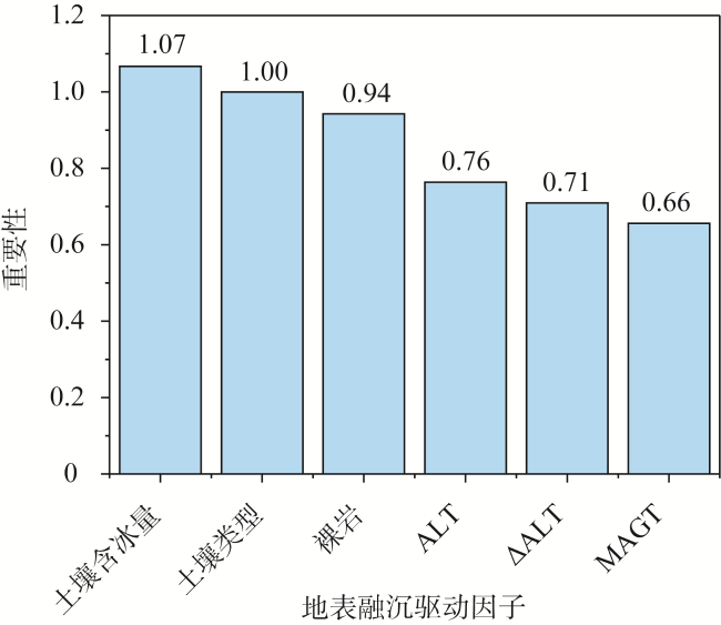
表7 各个指数的权重Tab. 7 The weight of different indices (%) |
| 形变 | 危险区指数 | 融沉指数 | 容许承载力指数 | |
|---|---|---|---|---|
| 权重 | 56 | 26 | 13 | 5 |
表9 3个地质灾害指数与形变之间的相关性Tab. 9 Correlations between three geo-hazard indices and deformation |
| 容许承载力指数 | 危险区划指数 | 融沉指数 | |
|---|---|---|---|
| R | -0.069 | 0.114 | 0.072 |
| P | 0.00 (<0.01) | 0.00 (<0.01) | 0.00 (<0.01) |
| [1] |
|
| [2] |
|
| [3] |
|
| [4] |
|
| [5] |
|
| [6] |
|
| [7] |
|
| [8] |
|
| [9] |
|
| [10] |
|
| [11] |
|
| [12] |
|
| [13] |
|
| [14] |
|
| [15] |
|
| [16] |
|
| [17] |
|
| [18] |
张中琼, 吴青柏, 周兆叶. 多年冻土区冻融灾害风险性评价[J]. 自然灾害学报, 2012, 21(2):142-149.
[
|
| [19] |
阮国锋, 张建明, 柴明堂. 气候变化情景下青藏工程走廊融沉灾害危险性区划研究[J]. 冰川冻土, 2014, 36(4):811-817.
[
|
| [20] |
|
| [21] |
|
| [22] |
|
| [23] |
|
| [24] |
|
| [25] |
|
| [26] |
|
| [27] |
|
| [28] |
|
| [29] |
|
| [30] |
马巍, 吴紫汪, 盛煜. 冻土的蠕变及蠕变强度[J]. 冰川冻土, 1994(2):113-8.
[
|
| [31] |
|
| [32] |
|
| [33] |
|
| [34] |
|
| [35] |
夏卓璇, 黄灵操, 刘琳. 青藏工程走廊沿线热融滑塌综合调查(2019). 时空三极环境大数据平台.
[
|
| [36] |
|
| [37] |
|
| [38] |
|
/
| 〈 |
|
〉 |