
联合InSAR与TPCA技术的兰州市地表形变信息提取及成因分析
|
闫莹莹(1999— ),女,河南周口人,硕士生,主要从事城市地表形变监测。E-mail: 444138848@qq.com |
Copy editor: 蒋树芳
收稿日期: 2024-06-03
修回日期: 2024-09-02
网络出版日期: 2024-11-07
基金资助
国家自然科学基金项目(42364003)
国家自然科学基金项目(41964008)
中央引导地方科技发展资金项目(23ZYQA0326)
Extraction and Genesis Analysis of Land Surface Deformation Information in Lanzhou City Using InSAR and TPCA Technology
Received date: 2024-06-03
Revised date: 2024-09-02
Online published: 2024-11-07
Supported by
National Natural Science Foundation of China(42364003)
National Natural Science Foundation of China(41964008)
Local Science and Technology Development Fund Projects under the Guidance of Central Government(23ZYQA0326)
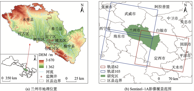
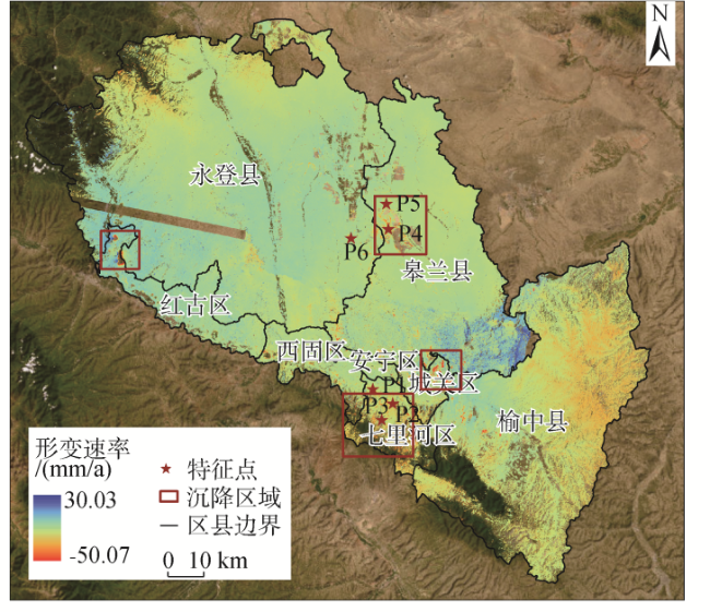
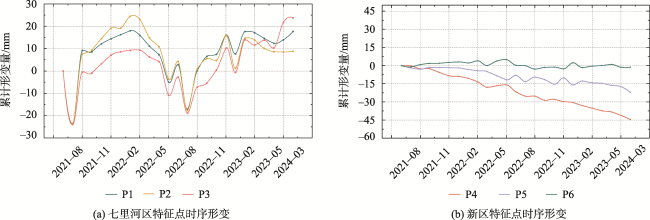
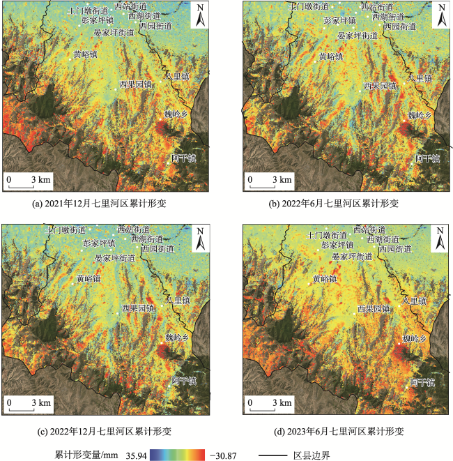
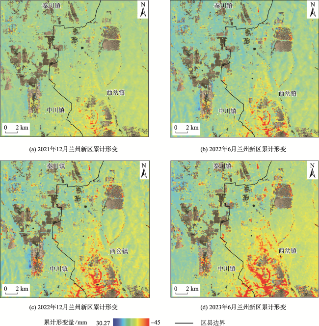
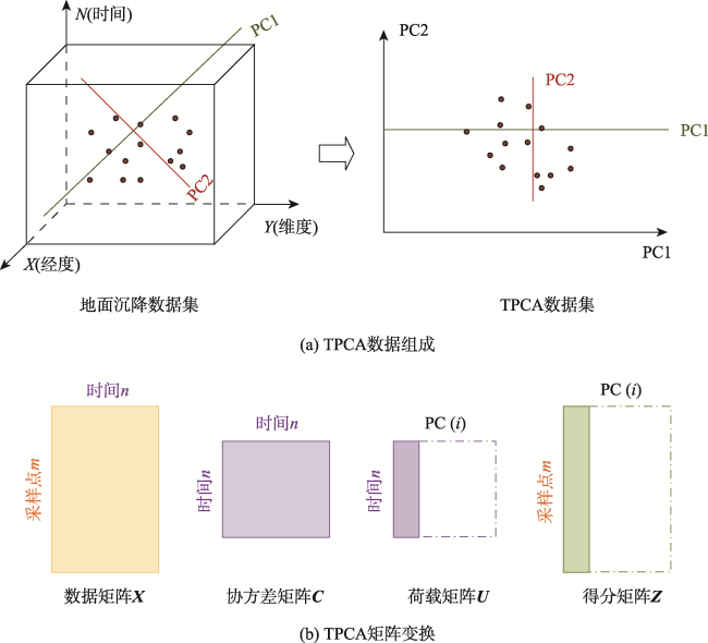
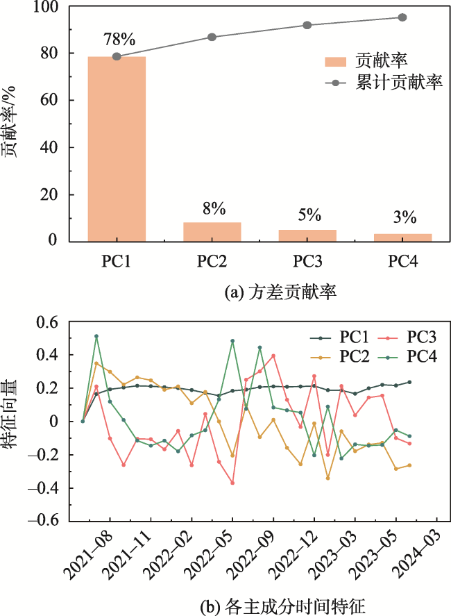
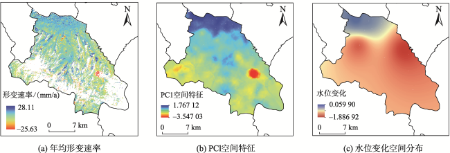
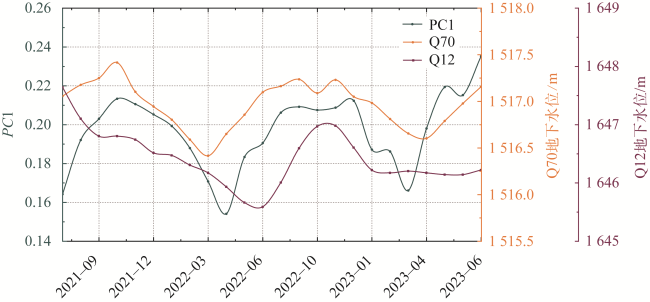
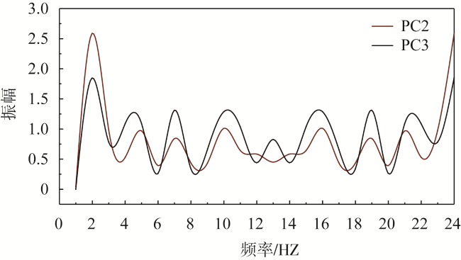
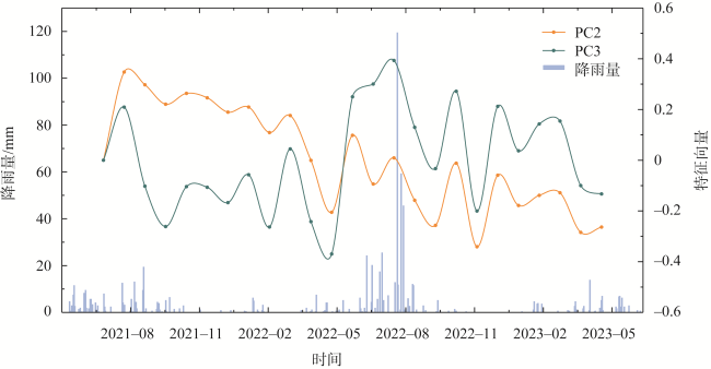
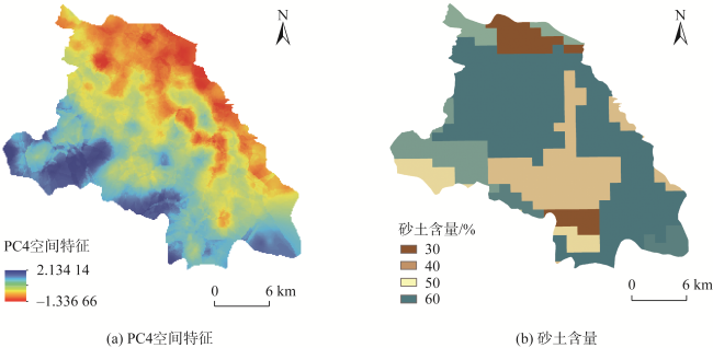
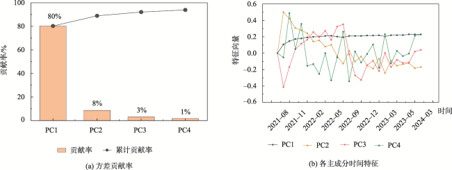
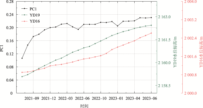
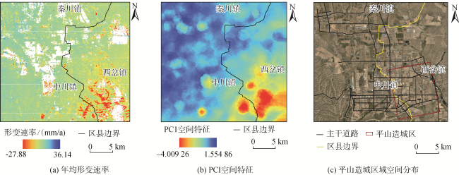
兰州作为西部大开发及丝绸之路的重要节点,在现代经济、文化和交通发展中具有关键战略地位。然而由于特殊的地理位置和黄土地质,地面沉降一直是威胁其生态环境和城市基础设施安全的重要问题。因此,准确识别沉降及评估驱动因子的影响,对防治黄土地区地面沉降至关重要。本文提出将SBAS-InSAR技术与时间主成分分析法(TPCA)相结合,深入分析兰州市地面沉降及其驱动因子,从时空角度挖掘沉降信息,定量分析各驱动因子的影响。首先利用SBAS-InSAR技术获取兰州市地表时序形变数据,在此基础上利用TPCA方法从时序形变数据中提取占比较大的主成分,最后结合各主成分信号对兰州市地面沉降驱动因子进行定量分析。结果表明:兰州市地面沉降主要集中在红古区西北部、七里河区南部、城关区北部和新区西岔镇,最大沉降速率达到45.87 mm/a。在沉降严重的七里河区和新区,前4个主成分可以解释90%以上的数据特征,其中第一主成分(PC1)包含原始数据75%以上的信息。特征区域PC1特征向量变化与不同监测井水位变化的相关系数均超过0.6,表明地下水变化是兰州市地面沉降的主要影响因素。本文方法在兰州市地面沉降分析中具有一定的应用价值,为黄土地区地面沉降的治理提供参考依据。

闫莹莹 , 魏冠军 , 何斌 . 联合InSAR与TPCA技术的兰州市地表形变信息提取及成因分析[J]. 地球信息科学学报, 2024 , 26(11) : 2583 -2596 . DOI: 10.12082/dqxxkx.2024.240310
Lanzhou is an important node in the development of the western region and the Silk Road, holding a key strategic position in the development of modern economy, culture, and transportation. However, due to its unique geographical location and distinctive loess topography, land subsidence has been a persistent issue that threatens the city's ecological environment and the safety of its urban infrastructure. Therefore, it is very important to accurately identify subsidence and evaluate the impact of driving factors to prevent and control land subsidence in loess areas. This paper proposes combining SBAS-InSAR technology with Time Series Principal Component Analysis (TPCA) to deeply analyze land subsidence and its driving factors in Lanzhou. By examining subsidence information from both temporal and spatial perspectives, the study quantitatively analyze the influence of various driving factors. Firstly, SBAS-InSAR technology is used to obtain time series deformation data of land surface in Lanzhou City. Then, TPCA is applied to extract the principal components that represent a significant proportion of the deformation data. Finally, the driving factors of land subsidence in Lanzhou city are quantitatively analyzed by combining the signals of each principal component. The results show that the land subsidence of Lanzhou city is concentrated in the northwestern part of Honggu District, the southern part of Qilihe District, the Northern part of Chengguan District,and the Xicha Town of the new district, with the maximum subsidence rate reaching 45.87 mm/year. In the Qilihe District and the new district, where the subsidence is severe, the first four principal components explain more than 90% of the data characteristics, with the first Principal Component(PC1)alone containing over 75% of the original data information. The correlation coefficient between the change in the PC1 characteristic vector in the characteristic area and the change in water levels in different monitoring wells is above 0.6, indicating that groundwater change is the main influencing factor of land subsidence in Lanzhou City. The method proposed in this paper has practical value in analyzing land subsidence in Lanzhou, providing a reference for managing land subsidence in loess areas.
表1 SAR影像具体参数Tab. 1 Specific parameters of SAR images |
| 卫星 | 轨道 编号 | 影像 数/景 | 时段 | 轨道 方向 | 极化 方式 |
|---|---|---|---|---|---|
| Sentinel-1A | 103 | 25 | 2021.6—2023.6 | ||
| 103 | 25 | 2021.6—2023.6 | 降轨 | VV | |
| 62 | 29 | 2021.6—2023.6 |
| [1] |
|
| [2] |
张可, 宫辉力, 李小娟, 等. 近场动力学理论在区域地面沉降建模中的应用研究[J]. 地球信息科学学报, 2023, 25(1):49-62.
[
|
| [3] |
|
| [4] |
|
| [5] |
|
| [6] |
|
| [7] |
朱建军, 李志伟, 胡俊. InSAR变形监测方法与研究进展[J]. 测绘学报, 2017, 46(10):1717-1733.
[
|
| [8] |
自然资源部. 《全国地质灾害防治“十四五”规划》[EB/OL].(2022-12-07)[2024-05-10]. https://www.gov.cn/zhengce/zhengceku/2023-01/04/content_5734957.htm.
[Ministry of Natural Resources. National 14th Five-Year Plan for Prevention and Control of Geologic Disasters[EB/OL].(2022-12-07)[2024-05-10]. https://www.gov.cn/zhengce/zhengceku/2023-01/04/content_5734957.htm.]
|
| [9] |
李蓉蓉, 杨维芳, 李得宴. SBAS-InSAR和SDE在兰州市城区地面沉降监测中的应用[J]. 兰州交通大学学报, 2021, 40(2):29-37.
[
|
| [10] |
张剑, 柯宝贵, 刘同木, 等. 利用时序InSAR监测兰州市中心城区地面沉降[J]. 测绘科学, 2021, 46(1):99-107,161.
[
|
| [11] |
|
| [12] |
焦美榕, 吴静, 李纯斌. 利用InSAR技术的兰州盆地地面沉降监测[J]. 国土与自然资源研究, 2023(4):59-64.
[
|
| [13] |
|
| [14] |
牛全福, 陆铭, 马亚娜, 等. PS-InSAR技术在兰州市地面形变中的监测应用[J]. 科学技术与工程, 2021, 21(19):7909-7915.
[
|
| [15] |
龚翔, 许强, 蒲川豪. 兰州新区平山造城竣工后地表形变InSAR时序监测与分析[J]. 武汉大学学报(信息科学版), 2024, 49(2):236-245.
[
|
| [16] |
|
| [17] |
刘晓祥, 高二涛, 罗益, 等. 利用主成分分析法分析GNSS坐标时间序列[J]. 大地测量与地球动力学, 2021, 41(1):43-48.
[
|
| [18] |
|
| [19] |
|
| [20] |
吴志春, 郭福生, 李华亮, 等. 主成分分析法在相山火山盆地蚀变分带解译中的应用[J]. 大地构造与成矿学, 2020, 44(3):385-403.
[
|
| [21] |
|
| [22] |
|
| [23] |
陈宇, 陈思, 李杰, 等. 融合主成分时空分析与时序InSAR的高精度地表形变信息提取—以徐州地区为例[J]. 地球信息科学学报, 2023, 25(12):2402-2417.
[
|
| [24] |
|
| [25] |
何旭, 何毅, 张立峰, 等. 联合InSAR与PCA的北京平原地面沉降时空分析[J]. 光谱学与光谱分析, 2022, 42(7):2315-2324.
[
|
| [26] |
赵亚丽, 王彦兵, 王新雨, 等. 利用TPCA分析北京平原区地面沉降的时空演化特征[J]. 武汉大学学报(信息科学版), 2022, 47(9):1498-1506.
[
|
| [27] |
朱亮, 刘景涛, 杨明楠, 等. 1998年以来兰州市地下水环境变化及驱动因素[J]. 中国地质, 2020, 47(6):1677-1687.
[
|
| [28] |
甘肃省水利厅. 《2022年甘肃省水资源公报》[EB/OL].(2023-09-25)[2024-05-10]. https://slt.gansu.gov.cn/slt/c106726/c106732/c106773/c106775/tld.shtml.
[Department of Water Resources of Gansu Province. Bulletin of Water Resources of Gansu Province in 2022[EB/OL](2023-09-25)[2024-05-10]. https://slt.gansu.gov.cn/slt/c106726/c106732/c106773/c106775/tld.shtml.]
|
| [29] |
甘肃省自然资源厅. 《甘肃省2023年地下水动态监测报告》[EB/OL].(2024-03-18)[2024-05-10]. https://zrzy.gansu.gov.cn/zrzy/c107676/202403/173876563.shtml.
[Department of Natural Resources of Gansu Province. Dynamic Monitoring Report of Groundwater in Gansu Province in 2023[EB/OL].(2024-03-18)[2024-05-10]. https://zrzy.gansu.gov.cn/zrzy/c107676/202403/173876563.shtml.]
|
| [30] |
中国地质调查局. 《地面沉降干涉雷达数据处理技术规程》[EB/OL].(2014-06-30)[2024-05-10]. https://std.cgs.gov.cn/content/26.
[China Geological Survey. Technical Sp-ecification for Ground Subsidence Interferometric Radar Data Processing[EB/OL].(2014-06-30)[2024-05-10]. https://std.cgs.gov.cn/content/26.]
|
| [31] |
周韩, 罗璟, 杨沛璋, 等. 基于土壤质地分类的土壤渗透性影响因素研究[J]. 人民长江, 2023, 54(8):153-159.
[
|
| [32] |
|
| [33] |
曹艳, 徐满. 中国近半大中型城市面临下沉危机[J]. 生态经济, 2024, 40(6):9-12.
[
|
/
| 〈 |
|
〉 |