
时序InSAR和LSTM结合的滑坡形变时空分析与预测方法
|
林娜(1981— ),女,湖北襄阳人,博士,副教授,主要从事遥感影像智能处理等方面的研究。E-mail: linnawb@126.com |
Office editor: 黄光玉
收稿日期: 2024-07-18
修回日期: 2024-09-10
网络出版日期: 2024-11-28
基金资助
重庆市自然科学基金面上项目(CSTB2023NSCQ-MSX0781)
教育部产学合作协同育人项目(220702313111054)
重庆交通大学研究生课程思政示范项目(KCSZ2023033)
重庆交通大学研究生科研创新项目(CYS240529)
重庆市研究生导师团队建设项目(JDDSTD2022002)
Spatiotemporal Analysis and Prediction of Landslide Deformation Combining Time-Series InSAR and LSTM
Received date: 2024-07-18
Revised date: 2024-09-10
Online published: 2024-11-28
Supported by
Chongqing Natural Science Foundation project(CSTB2023NSCQ-MSX0781)
Ministry of Education Industry-university Cooperative Education Project(220702313111054)
Chongqing Jiaotong University Graduate Course Ideological and Political Demonstration Project(KCSZ2023033)
Chongqing Jiaotong University Graduate Research Innovation Project(CYS240529)
Team Building Project for Graduate Tutors in Chongqing(JDDSTD2022002)
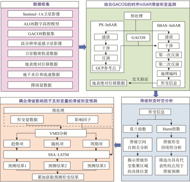
我国是受地质灾害影响最大的国家之一,研究高精度、高可靠性的滑坡形变监测与预测方法对于防灾减灾工作具有切实意义。以三峡库区藕塘特大滑坡为例,针对时序InSAR技术滑坡形变提取过程中面临大气干涉效应问题,在时序InSAR滑坡形变提取中引入GACOS进行大气校正,并通过GNSS观测数据进行验证对比;针对滑坡形变预测前较少考虑时空分析的问题,计算莫兰指数、Hurst指数分析滑坡形变时空特征;针对滑坡形变不仅受历史形变影响,还与多种影响因子密切相关的问题。本文提出将滑坡影响因子与形变量耦合用于滑坡形变预测,并采用结合变分模态分解(Variational Mode Decomposition, VMD)和麻雀搜索算法(Sparrow Search Algorithm, SSA)优化的长短期记忆网络(Long Short-Term Memory, LSTM)模型进行预测。通过VMD分解滑坡位移数据为趋势项、周期项和随机项,构建LSTM网络结构并使用SSA寻找LSTM模型最优的隐藏单元数目、最大训练周期和初始学习率,同时通过数据归一化、正则化和模型评估等方法提升LSTM模型的性能和稳定性,最后利用影响因子与分解后的位移数据训练LSTM模型并完成预测,得到滑坡形变的预测结果。结果表明: ① 2021年1月—2023年6月藕塘滑坡形变最高与最低速率分别为-72.75 mm/a、50.74 mm/a; ② 研究区形变具有正向空间自相关性、沉降区域滑坡形变具有持续趋势; ③ 结合VMD和SSA优化的LSTM模型滑坡形变预测误差仅为0.37 mm,较LSTM的精度提升了11.004%。本文基于时序InSAR技术,结合时空分析结果,构建了一种耦合多个影响因子与滑坡形变的高精度预测模型,为滑坡灾害的防治提供了重要的参考依据。

林娜 , 谭力兵 , 张迪 , 丁凯 , 李双桃 , 肖茂池 , 张精平 , 王小华 . 时序InSAR和LSTM结合的滑坡形变时空分析与预测方法[J]. 地球信息科学学报, 2024 , 26(12) : 2772 -2787 . DOI: 10.12082/dqxxkx.2024.240409
China is one of the countries most severely affected by geological disasters. Researching high-precision and highly reliable methods for monitoring and predicting landslide deformation holds practical significance for disaster prevention and mitigation efforts. Using the massive Outang landslide in the Three Gorges Reservoir Area as a case study, this paper addresses the issue of the atmospheric interference in extracting landslide deformation using time-series InSAR technology. To correct for atmospheric effects, the GACOS model is introduced and validated against GNSS observation data. To address the often-overlooked temporal-spatial analysis before landslide deformation prediction, the Moran index and Hurst index are calculated to analyze the spatiotemporal characteristics of landslide deformation. Recognizing that landslide deformation is influenced not only by historical deformation but also by various external factors, this paper proposes coupling landslide influencing factors with deformation data for prediction. A Long Short-Term Memory (LSTM) model, optimized by Variational Mode Decomposition (VMD) and the Sparrow Search Algorithm (SSA), is employed for the prediction. By decomposing landslide displacement data into trend, periodic, and random components using VMD, the LSTM network structure is constructed. SSA is used to determine the optimal number of hidden units, maximum training periods, and the initial learning rate of the LSTM model. Additionally, methods such as data normalization, regularization, and model evaluation are employed to enhance the performance and stability of the LSTM model. Finally, the model is trained using the influencing factors and decomposed displacement data to predict landslide deformation. The results indicate that: (1) From January 2021 to June 2023, the maximum and minimum deformation rates of the Outang landslide were -72.75 mm/a and 50.74 mm/a, respectively; (2) The deformation in the study area exhibits positive spatial autocorrelation, with the landslide in the settlement area showing a persistent trend; (3) The prediction error of the LSTM model optimized by VMD and SSA is only 0.37 mm, representing an 11.004% accuracy improvement compared to the standard LSTM model. Based on time-series InSAR technology and spatiotemporal analysis results, this paper constructs a high-precision prediction model for landslide deformation, incorporating multiple influencing factors. This model provides a valuable reference for the prevention and control of landslide disasters.
表1 数据来源与相关信息Tab. 1 Data sources and related information |
| 数据名称 | 时间跨度 | 分辨率 | 数据来源 |
|---|---|---|---|
| 卫星影像、卫星精密轨道数据 | 2021年1月—2023年6月 | 12 d | 美国阿拉斯加大学费尔班克斯校区的一个卫星数据处理中心(https://search.asf.alaska.edu/) |
| GACOS数据集 | 2021年1月—2023年6月 | 12 d | InSAR通用大气校正在线服务网站(http://www.gacos.net/) |
| ALOS数字高程模型 | 2010年9月—2010年11月 | 12.5 m | 重庆市基础地理信息数据库 |
| GF-1、GF-2以及ZY3-01高分辨率遥感 卫星影像数据 | 2018年5月—2023年4月 | 2~8 m | 国家高分辨率对地观测系统重庆数据与应用中心 |
| 8个GNSS监测站点的地表绝对位移数据 | 2022年5月—2023年7月 | 1 d | 重庆市地质灾害综合防治信息系统 |
| 1个雨量计观测站点降雨量数据 | 2022年5月—2023年7月 | 1 d | 重庆市地质灾害综合防治信息系统 |
| 9个水位测量仪观测站点的地下水位和 流速数据 | 2021年1月—2023年7月 | 1 d | 重庆市地质灾害综合防治信息系统 |
图3 2021年1月—2023年6月藕塘滑坡形变平均位移速率分布Fig. 3 Distribution map of mean displacement rate of landslide deformation from January 2021 to June 2023 |
表2 2022年5月—2023年7月藕塘滑坡各GNSS监测站点与InSAR形变点形变速率对比Tab. 2 Comparison of deformation rates between GNSS monitoring stations and InSAR deformation points in Youtang landslide from May 2022 to July 2023 |
| 设备编号 | 形变速率/(mm/month) | 评估指标/(mm/month) | ||||||
|---|---|---|---|---|---|---|---|---|
| GNSS | InSAR大气校正前 | InSAR大气校正后 | 改正前速率差 | 改正后速率差 | RMSE | MAE | ||
| GTA8 | -1.87 | -0.09 | -0.73 | -1.78 | -1.14 | 0.75 | 0.61 | |
| GTA9 | -0.58 | -0.22 | -0.55 | -0.36 | -0.03 | |||
| GTA0 | -1.80 | 0.26 | -0.35 | -2.06 | -1.45 | |||
| GTA1 | -0.56 | 0.10 | -0.85 | -0.66 | 0.29 | |||
| GTA2 | -0.83 | 0.34 | -0.36 | -1.17 | -0.47 | |||
| GTA3 | -0.47 | -0.15 | -0.96 | -0.32 | 0.49 | |||
| GTA4 | -0.52 | -0.51 | -0.94 | -0.01 | 0.42 | |||
| GTA5 | -0.69 | -0.78 | -1.28 | 0.09 | 0.59 | |||
| 均值 | -0.92 | -0.18 | -0.75 | -0.74 | -0.17 | |||
表3 SSA超参数寻优结果Tab. 3 Optimal hyperparameter tuning results for SSA |
| 超参数 | 初始参数 | SSA-LSTM | VMD-SSA-LSTM |
|---|---|---|---|
| 最优隐藏单元数目 | 100 | 51 | 300 |
| 最优最大训练周期 | 300 | 205 | 300 |
| 最优初始学习率 | 0.01 | 0.01 | 0.01 |
表4 4种模型训练结果评价指标对比Tab. 4 Comparison of four evaluation indexes of model training results |
| 评价指标 | 预测模型 | |||
|---|---|---|---|---|
| LSTM | SSA-LSTM | VMD-LSTM | VMD-SSA-LSTM | |
| RMSE/mm | 1.06 | 0.97 | 0.21 | 0.16 |
| MAE/mm | 0.87 | 0.78 | 0.16 | 0.12 |
| MAPE/% | 2.36 | 2.08 | 0.45 | 0.33 |
| R² | 0.885 | 0.903 | 0.991 | 0.995 |
表5 4种模型预测结果与评价指标对比Tab. 5 The prediction results of the four models were compared with the evaluation indexes |
| 评价指标 | 预测模型 | |||
|---|---|---|---|---|
| LSTM | SSA-LSTM | VMD-LSTM | VMD-SSA-LSTM | |
| 预测值/mm | -34.04 | -35.32 | -35.45 | -35.70 |
| RMSE/mm | 2.03 | 0.74 | 0.62 | 0.37 |
| MAPE/% | 5.63 | 2.06 | 1.70 | 1.02 |
| [1] |
魏冠军, 高茂宁. 结合TRIGRS模型的黄土滑坡危险性评价粒子滤波数据同化方法[J]. 地球信息科学学报, 2023, 25(10):2084-2092.
[
|
| [2] |
陈宇, 陈思, 李杰, 等. 融合主成分时空分析与时序InSAR的高精度地表形变信息提取——以徐州地区为例[J]. 地球信息科学学报, 2023, 25(12):2402-2417.
[
|
| [3] |
闫斌, 董建军, 梅媛. 高海拔石灰石排土场汛期潜在滑移区域的D-InSAR评价研究[J]. 安全与环境工程, 2023, 30(6):162-168.
[
|
| [4] |
|
| [5] |
|
| [6] |
杨书成, 黄国满, 程春泉. 基于DEM的SAR影像几何定位参数校正方法[J]. 地球信息科学学报, 2019, 21(4):580-587.
[
|
| [7] |
|
| [8] |
丁刘建, 陶秋香, 李涛, 等. 高分三号SAR影像广域范围联合几何检校技术[J]. 测绘学报, 2020, 49(5):598-610.
[
|
| [9] |
|
| [10] |
|
| [11] |
|
| [12] |
|
| [13] |
|
| [14] |
王震豪, 聂闻, 许汉华, 等. 基于EEMD-Prophet-LSTM的滑坡位移预测[J]. 中国科学院大学学报, 2023, 40(4):514-522.
[
|
| [15] |
|
| [16] |
|
| [17] |
|
| [18] |
史绪国, 徐金虎, 蒋厚军, 等. 时序InSAR技术三峡库区藕塘滑坡稳定性监测与状态更新[J]. 地球科学, 2019, 44(12):4284-4292.
[
|
| [19] |
白泽朝, 王彦平, 王振海, 等. 地基大视场SAR形变监测的非均匀大气相位校正方法[J]. 雷达学报, 2023, 12(1):53-63.
[
|
| [20] |
江南, 苏爱军. 基于诱发因素响应与DE-SVM模型的滑坡位移预测[J]. 安全与环境工程, 2018, 25(5):44-49,54.
[
|
| [21] |
|
| [22] |
|
| [23] |
|
| [24] |
|
| [25] |
|
| [26] |
杨文韬, 刘国林, 牛冲, 等. GACOS的SBAS-InSAR小尺度大气延迟改正及沉降监测[J]. 测绘科学, 2023, 48(6):73-81.
[
|
| [27] |
白希选, 张兵强, 徐昊, 等. 基于DEM与GACOS的InSAR同震形变场大气误差校正[J]. 大地测量与地球动力学, 2023, 43(2):191-197.
[
|
| [28] |
|
| [29] |
|
| [30] |
|
| [31] |
|
| [32] |
茹少峰, 马茹慧. 黄河流域生态环境脆弱性评价、空间分析及预测[J]. 自然资源学报, 2022, 37(7):1722-1734.
|
| [33] |
孙一可, 宫辉力, 陈蓓蓓, 等. 综合莫兰指数和交叉小波的不均匀沉降量化分析[J]. 国土资源遥感, 2020, 32(2):186-195.
[
|
| [34] |
|
| [35] |
|
| [36] |
|
| [37] |
刘航源, 陈伟涛, 李远耀, 等. 基于EEMD-CNN-LSTM的新型综合模型在滑坡位移预测中的应用[J/OL]. 地质力学学报, 2024:1-14.
[
|
| [38] |
林宇, 苏爱军. 重庆藕塘滑坡地下水位时间序列混沌性判别与预测[J]. 人民长江, 2020, 51(S1):102-105,131.
|
| [39] |
|
| [40] |
|
| [41] |
|
| [42] |
游淳淋, 黄明清, 丘浩禹. 基于多元数据归一化处理的破碎岩体质量分级[J]. 中国矿业, 2022, 31(8):158-164.
|
| [43] |
|
| [44] |
|
| [45] |
李兰茹, 孟涵, 姚成. 基于SSA-LSTM模型的增江流域洪水模拟[J]. 水利技术监督, 2023, 31(12):152-157.
[
|
| [46] |
姜文文, 夏英. 改进U-Net的多尺度特征融合遥感图像语义分割网络[J/OL]. 计算机科学, 2024:1-10.
[
|
| [47] |
|
| [48] |
|
| [49] |
|
| [50] |
代贞伟, 殷跃平, 魏云杰. 三峡库区藕塘滑坡特征、成因及形成机制研究[J]. 水文地质工程地质, 2015, 42(6):145-153.
[
|
| [51] |
黄达, 匡希彬, 罗世林. 三峡库区藕塘滑坡变形特点及复活机制研究[J]. 水文地质工程地质, 2019, 46(5):127-135.
[
|
| [52] |
阿拉斯加卫星设施数据搜索平台[EB/OL]. https://search.asf.alaska.edu/.
[ASF Search.[EB/OL]. https://search.asf.alaska.edu/.]
|
| [53] |
InSAR通用大气校正在线服务网[EB/OL]. http://www.gacos.net/.
[Generic Atmospheric Correction Online Service for InSAR (GACOS)[EB/OL]. http://www.gacos.net/.]
|
| [54] |
黄发明, 殷坤龙, 张桂荣, 等. 多变量PSO-SVM模型预测滑坡地下水位[J]. 浙江大学学报(工学版), 2015, 49(6):1193-1200.
[
|
| [55] |
黄发明, 殷坤龙, 杨背背, 等. 基于时间序列分解和多变量混沌模型的滑坡阶跃式位移预测[J]. 地球科学, 2018, 43(3):887-898.
[
|
/
| 〈 |
|
〉 |


