
基于街景与高分遥感影像的超大城市绿地高精度识别与空间特征解析
|
陈虹(1989— ),女,浙江台州人,博士生,研究方向为地理空间分析与城市遥感。E-mail: chenplan@126.com |
Office editor: 黄光玉
收稿日期: 2023-08-29
修回日期: 2024-10-09
网络出版日期: 2024-11-28
基金资助
国家重点研发计划项目(2023YFF0805904)
中国科学院百人计划青年项目(E43302020D)
中国科学院百人计划青年项目(E2Z105010F)
甘肃省自然科学基金项目(24JRRA250)
High-Precision Identification and Spatial Feature Analysis of Green Space in a Mega-City Based on Street View and High-Resolution Remote Sensing Images
Received date: 2023-08-29
Revised date: 2024-10-09
Online published: 2024-11-28
Supported by
National Key Research and Development Program of China(2023YFF0805904)
Talent introduction Program Youth Project of the Chinese Academy of Sciences(E43302020D)
Talent introduction Program Youth Project of the Chinese Academy of Sciences(E2Z105010F)
Natural Science Foundation of Gansu Province(24JRRA250)
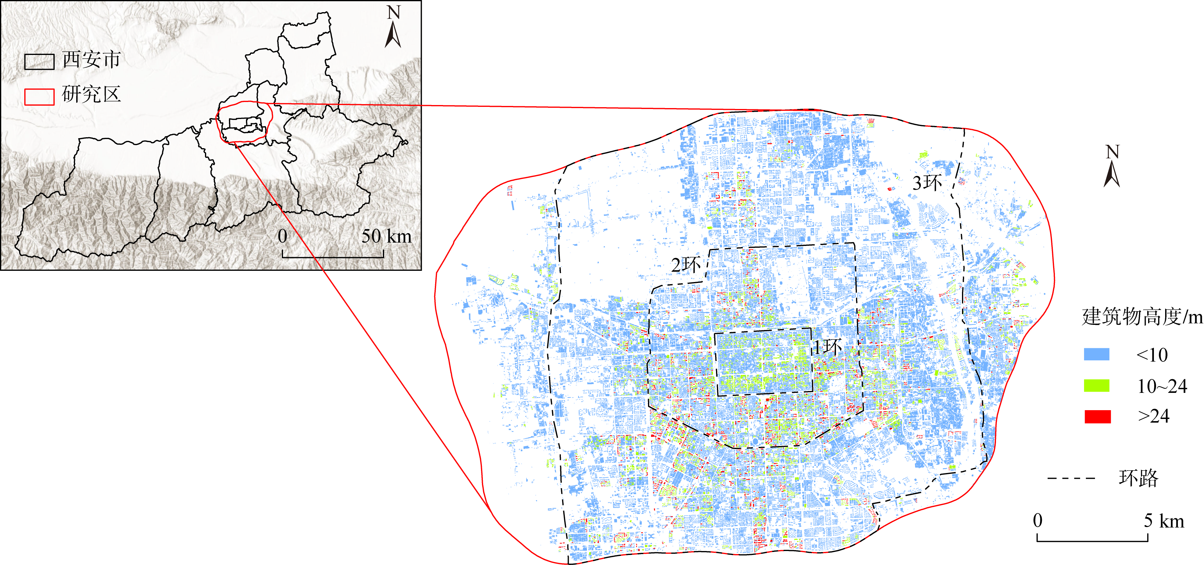
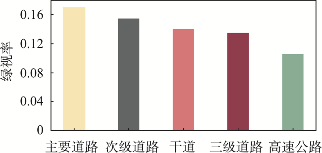
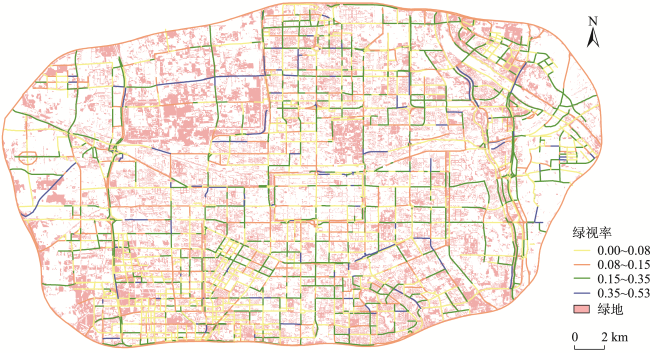
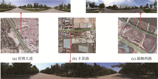
城市绿地是城市生态系统的关键组成部分,对改善生态环境和提高人居质量具有无法替代的作用。高精度的城市绿地识别是城市更新及绿色基础设施优化的基础,目前针对超大城市绿地的识别与空间异质性研究相对较少。本研究以西安市为例,结合城市街景图像与高分二号(GF-2)遥感影像,采用ISODATA分类、K-Means分类及卷积神经网络模型等方法,对绿地进行多维度、降尺度、高精度的识别与分析。结果表明: ① K-Means分类方法的识别精度(84.5%)显著高于ISODATA分类方法(62.4%),且更能准确映射绿地的空间特征与异质性规律, K-Means方法识别的绿地覆盖率为0.277 0,低于ISODATA的0.360 7; ② 西安主城区内街道平均绿视率为0.156 0,表明整体绿化水平良好,但不同道路存在明显的两极分化,其中30%的采样点的绿视率低于0.080 0;主城区整体呈现出高等级道路平均绿视率高于低等级道路的趋势,即主要道路>次要道路>干道>三级道路; ③ 西安主城区内街道绿视率与片区植被覆盖率整体呈现正相关,但在部分路段关联性较小,反映了街道地面纵剖面与天空俯视图的差异,二者结合可以更准确地评估和量化城市绿地。本研究可为西安市绿地规划、绿色基础设施建设和智慧管理提供一定借鉴,同时可为其他城市绿地的高精度识别与空间解析提供技术参考。
陈虹 , 汤军 , 龚阳春 , 陈志杰 , 王文达 , 王少华 . 基于街景与高分遥感影像的超大城市绿地高精度识别与空间特征解析[J]. 地球信息科学学报, 2024 , 26(12) : 2818 -2830 . DOI: 10.12082/dqxxkx.2024.230504
Urban green spaces are critical components of urban ecosystems, playing an irreplaceable role in improving the ecological environment and enhancing quality of life. High-precision identification of urban green spaces is fundamental for urban renewal and optimizing green infrastructure. However, research on the identification and spatial heterogeneity of green spaces in megacities remains relatively limited. This study, taking Xi'an as an example, integrates urban street view images and GF-2 (Gaofen-2) satellite imagery, employing methods such as ISODATA classification, K-Means classification, and convolutional neural networks to achieve multi-dimensional, downscaled, and high-precision identification and analysis of green spaces. The results indicate the following: (1) The K-Means classification method demonstrates significantly higher accuracy (84.5%) compared to the ISODATA classification method (62.4%) and more accurately maps the spatial characteristics and heterogeneity patterns of green spaces. The green space coverage identified by the K-Means method is 0.277 0, which is lower than the 0.360 7 identified by ISODATA. (2) The average Green View Index (GVI) of streets in Xi'an's main urban area is 0.156 0, indicating a generally good level of street greening. However, there is notable polarization across different roads, with 30% of sampling points having a GVI below 0.080 0. Overall, the GVI of higher-grade roads is greater than that of lower-grade roads, following the trend: primary roads > secondary roads > trunk roads > tertiary roads. (3) There is a positive correlation between the GVI of streets and the vegetation coverage in their surrounding areas in Xi'an's main urban area. However, this correlation weakens in certain road sections, reflecting differences between vertical cross-sections and overhead views of the streets. Combining these perspectives provides a more accurate assessment and quantification of urban green spaces. This study provides a reference for green space planning, green infrastructure construction, and smart management in Xi'an, as well as technical guidance for high-precision identification and spatial analysis of urban green spaces in other cities.
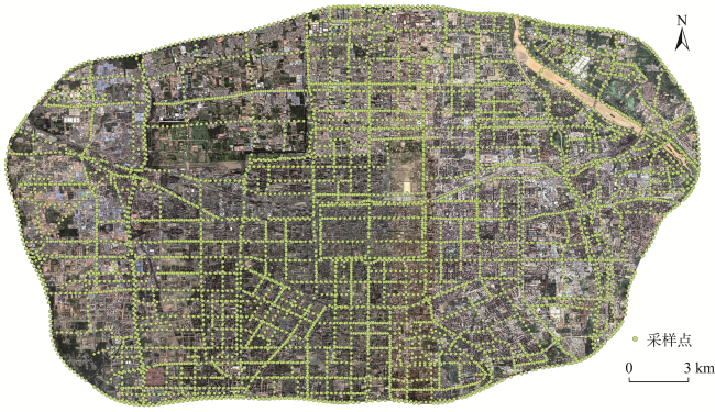
表1 数据源及特征Tab. 1 Data sources and features |
| 类别 | 数据 | 时间/年 | 分辨率 | 数据来源 |
|---|---|---|---|---|
| 遥感影像数据 | GF-2遥感影像 | 2018 | 4 m | 国家住房和城乡建设部 |
| 基础地理信息数据 | 行政边界 | 2017 2018 | - | 中国2017年1:100万全国基础地理数据库 Open Street Map矢量数据 |
| 路网 | - | |||
| 河流 | - | |||
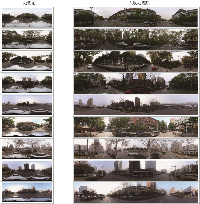
| 城市街景数据 | 街景图像 | 2021 | 1 024像素×512像素 | 百度地图 |
表2 样本可分离性分析结果Tab. 2 Analysis results of sample separability |
| 感兴趣区 | 绿地 | 建筑 | 水体 | 其他用地 |
|---|---|---|---|---|
| 绿地 | 1.965 3 | 1.990 7 | 1.805 5 | 1.945 5 |
| 建筑 | 1.864 8 | 1.846 8 | 1.857 5 | 1.984 7 |
| 水体 | 1.857 2 | 1.954 6 | 1.835 5 | 1.842 4 |
| 其他用地 | 1.963 5 | 1.945 8 | 1.246 8 | 1.845 4 |
表3 K-Means与ISODATA分类对比Tab. 3 Comparison between K-Means and ISODATA classification |
| 地区 | 高分影像 | K-Means分类结果 | ISODATA分类结果 |
|---|---|---|---|
| 大明宫遗址 | 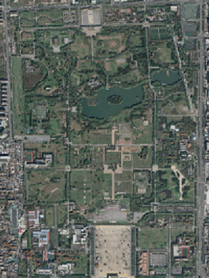 | 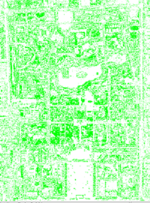 |  |
| 大唐芙蓉园 | 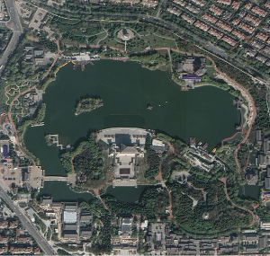 | 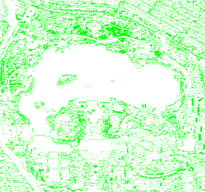 |  |
| 钟楼 |  | 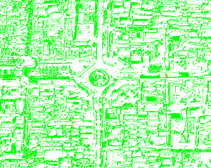 | 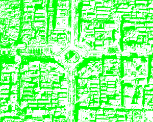 |
表4 绿视率计算结果Tab. 4 Calculation results of green view index |
| 类别 | 面积占比 | 绿视率 | |||
|---|---|---|---|---|---|
| 5(树) | 10(草) | 18(植物) | 67(花) | ||
| 0 | 0.011 2 | 0 | 0 | 0 | 0.011 2 |
| 1 | 0.029 2 | 0 | 0 | 0 | 0.029 2 |
| 2 | 0.213 1 | 0.006 0 | 0.000 3 | 0 | 0.219 4 |
| 3 | 0.172 0 | 0.019 8 | 0.005 9 | 0 | 0.197 7 |
| 4 | 0.319 0 | 0.030 1 | 0 | 0 | 0.349 1 |
| 5 | 0.179 0 | 0.036 3 | 0 | 0 | 0.215 3 |
| … | … | … | … | … | … |
| 7976 | 0.023 7 | 0 | 0.006 9 | 0 | 0.030 6 |
| 7977 | 0.161 7 | 0.003 9 | 0 | 0 | 0.165 6 |
| 7978 | 0.133 3 | 0.000 7 | 0.000 6 | 0 | 0.134 6 |
| 7979 | 0.182 0 | 0.002 8 | 0.014 7 | 0 | 0.199 4 |
| 7980 | 0.225 2 | 0.000 7 | 0.009 7 | 0 | 0.235 7 |
| [1] |
|
| [2] |
周亮, 车磊, 周成虎. 中国城市绿色发展效率时空演变特征及影响因素[J]. 地理学报, 2019, 74(10):2027-2044.
[
|
| [3] |
|
| [4] |
欧阳晓, 贺清云, 朱翔. 多情景下模拟城市群土地利用变化对生态系统服务价值的影响——以长株潭城市群为例[J]. 经济地理, 2020, 40(1):93-102.
[
|
| [5] |
|
| [6] |
韩晔, 周忠学. 西安市绿地景观吸收雾霾生态系统服务测算及空间格局[J]. 地理研究, 2015, 34(7):1247-1258.
[
|
| [7] |
|
| [8] |
|
| [9] |
|
| [10] |
|
| [11] |
|
| [12] |
万江琴, 费腾. 基于街景图像的“三生空间”识别方法研究[J]. 地球信息科学学报, 2023, 25(4): 838-851.
[
|
| [13] |
BADAWI(巴达卫) R. 基于高分辨率遥感影像的南京典型城区绿地信息提取[D]. 南京: 南京大学, 2012.
[
|
| [14] |
余东行, 张保明, 赵传, 等. 联合卷积神经网络与集成学习的遥感影像场景分类[J]. 遥感学报, 2020, 24(6):717-727.
[
|
| [15] |
|
| [16] |
|
| [17] |
|
| [18] |
张友水, 冯学智, 都金康, 等. IKONOS影像在城市绿地提取中的应用[J]. 地理研究, 2004, 23(2):274-280,284.
[
|
| [19] |
聂敏莉. 基于Quickbird卫星影像的城市绿地提取与分类研究[D]. 北京: 北京林业大学, 2010.
[
|
| [20] |
陈亚萍, 郑伯红, 曾祥平. 基于街景和遥感影像的城市绿地多维度量化研究——以郴州市为例[J]. 经济地理, 2019, 39(12):80-87.
[
|
| [21] |
田晓磊. 基于多源遥感数据的城市绿量测算[D]. 兰州: 兰州大学, 2022.
[
|
| [22] |
王旻烨, 费鲜芸, 谢宏全, 等. 城市绿地信息提取中高分辨率卫星影像融合方法研究[J]. 测绘通报, 2017(8):36-40.
[
|
| [23] |
张金营. 基于高分辨率遥感影像提取城市绿地信息的方法研究[D]. 东营: 中国石油大学(华东), 2012.
[
|
| [24] |
汪雪淼, 孟庆岩, 赵少华, 等. GF-2在城市绿地分类及景观格局度量中的应用[J]. 地球信息科学学报, 2020, 22(10):1971-1982.
[
|
| [25] |
刘良云, 王纪华, 赵春江, 等. 基于地物空间信息的浮动先验概率最大似然分类研究[J]. 遥感学报, 2006, 10(2):227-235.
[
|
| [26] |
刘丽雅. 基于国产GF-1的高寒山区土地利用/覆盖分类研究[D]. 杭州: 浙江大学, 2016.
[
|
| [27] |
吕杰. 基于Hyperion高光谱遥感数据的城市绿地信息提取方法的研究[D]. 北京: 中国地质大学(北京), 2009.
[
|
| [28] |
黄慧萍, 吴炳方, 李苗苗, 等. 高分辨率影像城市绿地快速提取技术与应用[J]. 遥感学报, 2004, 8(1):68-74.
[
|
| [29] |
刘智谦, 吕建军, 姚尧, 等. 基于街景图像的可解释性城市感知模型研究方法[J]. 地球信息科学学报, 2022, 24(10):2045-2057.
[
|
| [30] |
|
| [31] |
|
| [32] |
肖希, 韦怡凯, 李敏. 日本城市绿视率计量方法与评价应用[J]. 国际城市规划, 2018, 33(2):98-103.
[
|
| [33] |
|
| [34] |
邵振峰, 孙悦鸣, 席江波, 等. 智能优化学习的高空间分辨率遥感影像语义分割[J]. 武汉大学学报(信息科学版), 2022, 47(2):234-241.
[
|
| [35] |
吴立蕾. 基于绿视率的城市道路绿地设计研究[D]. 上海: 上海交通大学, 2008.
[
|
| [36] |
陈晋, 陈云浩, 何春阳, 等. 基于土地覆盖分类的植被覆盖率估算亚像元模型与应用[J]. 遥感学报, 2001, 5(6):416-422.
[
|
| [37] |
袁德宝, 王子林, 李雪莹, 等. 基于改进U-Net的遥感影像城镇绿地提取[J]. 遥感信息, 2023, 38(1):33-39.
[
|
| [38] |
陈周, 费鲜芸, 高祥伟, 等. 高分辨率遥感影像分割的城市绿地提取研究[J]. 测绘通报, 2020(12):17-20.
[
|
| [39] |
徐智邦, 焦利民, 贾琦琪, 等. 标度律视角的城市效能测度及中国城市多维要素效能分析[J]. 地理研究, 2021, 40(6):1596-1609.
[
|
| [40] |
|
/
| 〈 |
|
〉 |
